Streamwise Vorticity Current (SVC) & Low-Level Mesocyclogenesis: How Forward-Flank Baroclinic Vorticity Ingestion Supercharges Tornadic Updrafts
1. Opening Scene: The Breath Before the Whirlwind
The afternoon heat over the high plains of eastern Colorado has an oppressive, metallic weight. At four o’clock, the prairie stands motionless under a relentless sun, the scent of parched buffalo grass giving way to a sudden, inexplicable fragrance—the sharp, mineral tang of petrichor and ozone drifting from thirty miles away. You feel the storm before you see it: a subtle, popping pressure sensation deep in the middle ear as the local barometric field dips by several millibars in a matter of minutes.
Looking northeastward across the amber horizon, the sky curdles into an impenetrable blue-black anvil that spreads across the upper troposphere. Beneath this vast atmospheric canopy sits an ominous, rain-free cloud base, carved sharp and smooth against the distant plains. As the ambient wind shifts, the air abruptly cools by several degrees Celsius, yet it does not feel stagnant. Instead, a persistent, laminar draught begins rushing across the ground from the southeast, accelerating directly toward the dark underbelly of the storm.
       [ Updraft Core / Mesocyclone Base ]
                    / \
                   /   \  <-- Rapid Vertical Tilt & Ascent
                  /     \
    ============================================= Ground Level (AGY-OBS)
           <--- [ Inflow Stream ] --- [ SVC Roll Cloud ] <---
           Cold Pool Boundary (FFD) ===> Baroclinic Generation
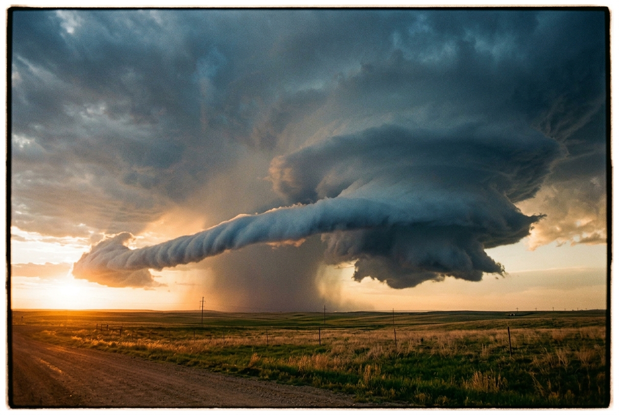
Then, emerging from the rain-drenched northern curtain of the storm, something remarkable materialises. A low-hanging, smooth, cylindrical cloud—resembling an elongated tail or a horizontal roll—stretches out from the precipitation core and snakes directly into the storm’s violent updraft. It does not tumble chaotically. Rather, it appears to corkscrew along its own axis of travel with hypnotic, laminar grace, gliding barely two hundred metres above the wheat fields. The local wind whips into a sustained gale, cold on the left cheek, warm and muggy on the right. This smooth inflow channel is not merely a passive cloud; it is the visual signature of an immense atmospheric dynamo known as the Streamwise Vorticity Current.
2. What’s Actually Happening — Plain English First
To understand why this sleek cloud feature matters, we must first examine how air moves when it spins. Imagine rolling a cardboard poster tube across a flat table. The tube rotates around an axis that is perpendicular to the direction it rolls across the wood. If you were running alongside the tube, you would see it tumbling end-over-end. In meteorology, this is known as crosswise spin (or crosswise vorticity).
Now, imagine an expertly thrown rugby ball or American football slicing through the evening air. The ball does not tumble end-over-end; instead, it spins tightly around the exact axis along which it flies. Its rotation is aligned parallel to its direction of motion. In fluid mechanics, this is called streamwise spin (or streamwise vorticity).
   CROSSWISE SPIN (Tumbling Log)        STREAMWISE SPIN (Spiral Football)

        Rotation Axis                         Velocity Vector (Direction of Flight)
            |                                 ==================================>
            v                                      /---------------------\
      [============]  --> Motion                  (       @ @ @ @ @       ) =====>
      [============]                               \---------------------/
                                                    Rotation Axis Aligned with Path
Why does this distinction decide the fate of a thunderstorm?
Think of the atmosphere as a layered cake—each vertical slice having a slightly different temperature, moisture content, and horizontal wind speed. As warm air near the ground rushes into a developing thunderstorm, it encounters differences in speed and direction at higher altitudes. This vertical wind shear naturally creates invisible, horizontal rolls of spinning air near the earth's surface—much like the tumbling cardboard tube.
When a storm’s ferocious central updraft—a column of warm, buoyant air rising at sixty miles per hour—inhales these horizontal tubes of spin, it has to lift them into the vertical. If the tube is tumbling crosswise, the updraft bends the tube into a horseshoe shape. This creates two competing, oppositely spinning vortices that tear at the updraft’s flanks, causing turbulent drag and choking off the storm's core.
However, if the incoming horizontal spin is purely streamwise—corkscrewing forward like a well-thrown football—the updraft can ingest it without any lateral resistance. The horizontal corkscrew simply turns upward ninety degrees into the vertical, instantly transferring all of its intense, pre-packaged rotation directly into the heart of the storm.
For decades, meteorologists wondered where a supercell could acquire such perfectly aligned, high-energy streamwise spin close to the ground, especially on days when the broader environment lacked strong ambient rotation. The answer lies within the storm itself: along the boundary where cold, rain-cooled air meets warm, ambient inflow, the storm constructs its own internal vorticity factory.
3. The Science: Fluid Dynamics and the Supercell Engine
Atmospheric rotation is formally quantified through the vorticity vector $\boldsymbol{\omega}$, defined as the curl of the three-dimensional velocity field $\mathbf{u} = (u, v, w)$:
$$\boldsymbol{\omega} = \nabla \times \mathbf{u} = \left( \frac{\partial w}{\partial y} - \frac{\partial v}{\partial z}, \, \frac{\partial u}{\partial z} - \frac{\partial w}{\partial x}, \, \frac{\partial v}{\partial u} - \frac{\partial u}{\partial y} \right)$$
In the lower boundary layer beneath a convective storm, horizontal wind variations are dominated by vertical shear ($\frac{\partial u}{\partial z}, \frac{\partial v}{\partial z}$). Consequently, the horizontal vorticity vector is approximated as:
$$\boldsymbol{\omega}_h \approx \left( -\frac{\partial v}{\partial z}, \, \frac{\partial u}{\partial z}, \, 0 \right)$$
Helicity Density and Streamwise Partitioning
To assess whether this horizontal vorticity aids or resists convective updraft rotation, fluid dynamicists evaluate the storm-relative wind vector $\mathbf{v}_{rel} = \mathbf{v} - \mathbf{c}$, where $\mathbf{c}$ is the translation velocity of the supercell. The relative helicity density $h$ represents the scalar projection of vorticity onto the storm-relative wind:
$$h = \mathbf{v}_{rel} \cdot \boldsymbol{\omega}$$
The degree to which the total horizontal vorticity is aligned with the inflow trajectory is governed by the normalized streamwise vorticity fraction ($\xi_{s}$):
$$\xi_{s} = \frac{|\mathbf{v}{rel} \cdot \boldsymbol{\omega}_h|}{|\mathbf{v}{rel}| |\boldsymbol{\omega}_h|} = \cos \theta$$
where $\theta$ is the angle between the relative inflow velocity vector and the horizontal vorticity vector. When $\xi_s = 1$, the vorticity is purely streamwise; when $\xi_s = 0$, it is purely crosswise.
       ================================================================
       HELICITY DENSITY FORMULA
       ================================================================
       h = v_rel · ω = ||v_rel|| ||ω|| cos(θ)

       Where:
         v_rel : Storm-relative wind velocity vector (m/s)
         ω     : Three-dimensional vorticity vector (s⁻¹)
         θ     : Angle between inflow trajectory and vorticity vector
       ================================================================
Baroclinic Generation along the Forward-Flank Downdraft (FFD)
While environmental wind shear provides background vorticity, the intense rotation within the lowest 500 metres above ground level (AGL) is generated primarily via baroclinic torque. Inside a supercell, hydrometeors (rain and hail) evaporate and melt within the Forward-Flank Downdraft (FFD), establishing an expansive cold pool beneath the precipitation core.
The interface between this dense, negatively buoyant cold pool and the warm ambient inflow creates a sharp horizontal gradient in virtual potential temperature ($\nabla_h \theta_v$). The baroclinic vorticity generation rate is given by the curl of the buoyancy acceleration:
$$\left( \frac{\partial \boldsymbol{\omega}h}{\partial t} \right){baro} = \nabla \times (B \mathbf{k}) = \nabla_h B \times \mathbf{k} \approx \frac{g}{\theta_{v0}} \left( \frac{\partial \theta_v}{\partial y} \mathbf{i} - \frac{\partial \theta_v}{\partial x} \mathbf{j} \right)$$
Here, $g$ is gravitational acceleration ($9.81\text{ m s}^{-2}$), $\theta_{v0}$ is the reference virtual potential temperature (typically $\approx 300\text{ K}$), and $B \approx g \frac{\theta_v'}{\theta_{v0}}$ represents thermal buoyancy.
Because air parcels flowing toward the updraft travel parallel along the northern flank of this thermal boundary before entering the low-pressure core, the baroclinic torque continuously generates horizontal vorticity whose vector is oriented parallel to the inflow streamlines. Thus, the FFD cold pool acts as an in-situ factory producing horizontal vorticity with $\xi_s \to 1.0$.
Kinematic Updraft Tilting
As this ribbon of air accelerates into the storm's low-level mesocyclone, the horizontal vorticity is converted into vertical vorticity ($\zeta = \omega_z$) through kinematic updraft tilting. The governing prognostic equation for vertical vorticity in an inviscid Boussinesq fluid is:
$$\frac{d\zeta}{dt} = \underbrace{\left( \boldsymbol{\omega}h \cdot \nabla_h \right) w}{\text{Tilting}} + \underbrace{\zeta \frac{\partial w}{\partial z}}{\text{Stretching}} + \underbrace{\left( \frac{\partial B}{\partial x}\frac{\partial z}{\partial y} - \frac{\partial B}{\partial y}\frac{\partial z}{\partial x} \right)}{\text{Solenoidal / Baroclinic}}$$
When horizontal vorticity is strictly streamwise ($\boldsymbol{\omega}_h = \omega_s \hat{\mathbf{s}}$, where $\hat{\mathbf{s}}$ is the unit vector along the horizontal streamline $s$), the tilting term reduces directly to:
$$\left( \boldsymbol{\omega}_h \cdot \nabla_h \right) w = \omega_s \frac{\partial w}{\partial s}$$
       ================================================================
       EQUATION: STREAMWISE VORTICITY TILTING RATE
       ================================================================
       (dζ / dt)_tilt = ω_s · (∂w / ∂s)

       Plain English Prediction:
       The rate at which vertical rotation forms equals the intensity of
       the corkscrew spin multiplied by the rapid acceleration of upward
       draft speed along the path of the incoming air.
       ================================================================
Because the vertical velocity $w$ increases monotonically as an inflow parcel approaches and enters the updraft core ($\frac{\partial w}{\partial s} > 0$), streamwise vorticity converts cleanly into a single, concentrated cyclonic vertical vortex coincident with the updraft maximum. Crosswise vorticity, by contrast, relies on transverse gradients ($\omega_c \frac{\partial w}{\partial n}$), which splits the circulation into an asymmetric dipole and induces turbulent shear stresses that degrade the updraft's structural integrity.
Quantitative Demonstration: Calculating Ingestion and Tilting
To observe these fluid mechanics in action, consider a realistic observational scenario from a Great Plains supercell sampled by research radar:
1. Environmental and Boundary Conditions
- Reference virtual potential temperature: $\theta_{v0} = 300\text{ K}$
- Horizontal temperature deficit across the FFD boundary: $\Delta \theta_v = -4.0\text{ K}$ over a transition distance of $\Delta n = 2,000\text{ m}$
- Magnitude of thermal gradient: $$|\nabla_h \theta_v| = \frac{4.0\text{ K}}{2,000\text{ m}} = 2.0 \times 10^{-3}\text{ K m}^{-1}$$
- Storm-relative inflow speed: $|\mathbf{v}_{rel}| = 22.0\text{ m s}^{-1}$
- Residence time of parcel along thermal boundary: $\Delta t = 250\text{ s}$
- Updraft vertical velocity gradient: $w$ rises from $0\text{ m s}^{-1}$ at the cloud base entrance to $25.0\text{ m s}^{-1}$ over a horizontal streamline distance of $\Delta s = 1,000\text{ m}$ ($\frac{\partial w}{\partial s} = 0.025\text{ s}^{-1}$).
2. Calculation of Generated Streamwise Vorticity
The baroclinic generation rate of horizontal vorticity along the path is:
$$\dot{\omega}s = \frac{g}{\theta{v0}} |\nabla_h \theta_v| = \left( \frac{9.81\text{ m s}^{-2}}{300\text{ K}} \right) \left( 2.0 \times 10^{-3}\text{ K m}^{-1} \right) = 6.54 \times 10^{-5}\text{ s}^{-2}$$
Integrating over the 250-second transit yields:
$$\omega_s = \dot{\omega}_s \cdot \Delta t = (6.54 \times 10^{-5}\text{ s}^{-2}) \times (250\text{ s}) \approx 0.01635\text{ s}^{-1}$$
3. Calculation of Vertical Vorticity Generation via Tilting
As this parcel enters the updraft gradient, the instantaneous production rate of vertical vorticity $\zeta$ via tilting is:
$$\left(\frac{d\zeta}{dt}\right)_{tilt} = \omega_s \left( \frac{\partial w}{\partial s} \right) = (0.01635\text{ s}^{-1}) \times (0.025\text{ s}^{-1}) = 4.0875 \times 10^{-4}\text{ s}^{-2}$$
Over a 40-second passage through the primary updraft gradient zone, the tilted vertical vorticity acquired is:
$$\zeta_{tilted} = \left(\frac{d\zeta}{dt}\right){tilt} \cdot \Delta t{tilt} = (4.0875 \times 10^{-4}\text{ s}^{-2}) \times (40\text{ s}) \approx 0.01635\text{ s}^{-1}$$
       ================================================================
       WORKED RESULT SUMMARY: LOW-LEVEL MESOCYCLOGENESIS
       ================================================================
       Baroclinic Generation Rate (ω_s)  : 6.54 × 10⁻⁵ s⁻²
       Accumulated Streamwise Vorticity   : 1.64 × 10⁻² s⁻¹
       Updraft Tilting Efficiency         : 100% (Pure Streamwise Mode)
       Resulting Vertical Vorticity (ζ)   : 1.64 × 10⁻² s⁻¹
       Context: Values of ζ > 10⁻² s⁻¹ within the lowest 500 m AGL
       exceed ambient synoptic vorticity by three orders of magnitude,
       providing the critical seed for rapid vortex stretching.
       ================================================================
High-Resolution Numerical Modeling: The Orf et al. Paradigm
For decades, classic tornadogenesis theory assumed that tornadoes formed primarily when mid-level mesocyclones dynamically descended to the surface, or through the rear-flank downdraft (RFD) dragging mid-level spin downward. However, pioneering ultra-high-resolution simulations conducted on the Blue Waters supercomputer by Leigh Orf et al. (resolving convective grids down to sub-30-metre spacing) revealed a radically different mechanism: the Streamwise Vorticity Current (SVC).
These simulations demonstrated that the SVC is an autonomous, ground-hugging helical river of air that forms entirely within the storm's sub-cloud boundary layer (below 500 metres AGL). Rather than descending from above, the SVC forms along the northern periphery of the forward-flank cold pool, drawing in vorticity created by baroclinic temperature gradients. The current then rolls dynamically into a coherent horizontal tube that is ingested directly into the low-level updraft.
                  ======================================
                  THE STREAMWISE VORTICITY CURRENT (SVC)
                  ======================================

                         [ MAIN UPDRAFT VAULT ]
                                  ^  ^  ^
                                 /  /  /  <-- Tilting Zone (0-500m AGL)
                                /  /  /
        [ FFD Precipitation ]  /  /  /
        ===================|  /  /  /
        Dense Rain / Hail  | (@@@@@)  <-- Helical SVC Tube (100-300m AGL)
        Cold Pool (θ_v - 4K)|  ^  ^
        -------------------|  |  |   <-- Continuous Baroclinic Torque
                           |  |  |
             Ambient Inflow Vector (θ_v + 0K) ===>
The Orf et al. findings fundamentally resolved a long-standing meteorological paradox: why violent tornadoes frequently develop in environments where ambient low-level storm-relative helicity (SRH) appears marginal on standard weather balloon soundings. The supercell does not merely consume environmental rotation; it builds an internal fluid accelerator that magnifies ambient vorticity by orders of magnitude right at the ground, driving tornadogenesis from the bottom up.
To explore further technical classifications of convective dynamics and severe local storms, consult resources provided by the NOAA National Severe Storms Laboratory (NSSL), the Met Office Weather Learning Guide, the World Meteorological Organization Cloud Atlas, the American Meteorological Society Glossary, and the UCAR COMET Atmospheric Training Program.
4. Practical Outdoor Guidance: Field Observation and Measurement
Recognising the signatures of streamwise vorticity current ingestion is vital for field researchers, storm spotters, and outdoor enthusiasts navigating severe convective environments.
       ================================================================
       FIELD OBSERVER'S INSTRUMENT & VISUAL MATRIX
       ================================================================
       PARAMETER          OBSERVED VALUE / SIGNATURE      PHYSICAL MEANING
       ----------------------------------------------------------------
       Barometer          Rapid drop (2 to 6 hPa / 10m)  Proximity to core updraft
       Thermometer        Sharp 2°C to 5°C thermal drop   Crossing FFD cold pool boundary
       Anemometer         Sustained backing (SE to ENE)   Inflow acceleration into SVC
       Visual Cloud       Smooth "beaver-tail" roll       Laminar streamwise condensation
       ================================================================
What to Look for in the Sky
- The Inflow Band / "Beaver Tail": Look toward the precipitation core on the northeast flank of a storm. A smooth, laminar cloud band extending horizontally out from the rain curtain toward the updraft base indicates active ingestion of an SVC. If this roll cloud displays visible corkscrew rotation along its axis, high streamwise helicity is present.
- Laminar Cloud Textures: Rough, bubbly, or cauliflower-like textures indicate turbulent, crosswise shear. In contrast, smooth, striated, or "brushed" cloud textures beneath the rain-free base signal pure streamwise flow, where turbulence is suppressed by intense directional alignment.
- Rapid Horizontal Acceleration: Observe cloud tags (scud) near the ground. Scud racing horizontally at high speed toward a central convergence point without rising immediately indicates a strong boundary-layer inflow jet feeding an SVC.
Instrumental Signatures
- Barometric Pressure: A high-precision digital barometer will register a steep downward trend—often dropping 1.5 to 4.0 hPa within 15 minutes—as the local observation point enters the mesolow induced by the developing low-level mesocyclone.
- Surface Temperature & Moisture: A sudden drop of 2°C to 4°C in dry-bulb temperature accompanied by a rise in relative humidity indicates that your position has sampled the baroclinic gradient along the FFD boundary.
- Wind Vane Backing: In the Northern Hemisphere, surface winds backing rapidly (shifting counter-clockwise from south-southwest to east-southeast) accompanied by an increase in sustained velocity to 15–25 m/s confirms that ambient shear is becoming dynamically aligned into the storm’s relative inflow vector.
Practical Rules of Thumb
- For Hikers and Campers: If a dark storm approaches and the surface wind suddenly turns cold while blowing directly toward the rain rather than away from it, you are standing in an active inflow boundary. Seek sturdy shelter immediately; this indicates an intensifying supercell capable of rapid tornadogenesis.
- For Mariners and Aviators: Never attempt to transit the gap between a rain curtain and an adjacent low-hanging horizontal roll cloud. This zone harbours intense low-level wind shear, extreme horizontal vorticity, and severe localized vertical accelerations ($\frac{\partial w}{\partial z} > 0.05\text{ s}^{-1}$).
5. Today’s Meteorological Rule of Thumb
"When cold outflow runs parallel to warm inflow, the boundary rolls; when the storm inhales that roll along its length, a vortex is born."
Whenever you observe smooth, striated cloud ribbons corkscrewing horizontally into a dark storm base rather than tumbling chaotically across the sky, you are witnessing the atmosphere's most efficient engine—the Streamwise Vorticity Current—converting horizontal thermodynamics into vertical fury.
Authoritative References & Scientific Resources
- Detailed supercell dynamics and radar analysis: NOAA National Severe Storms Laboratory (NSSL)
- Atmospheric thermodynamics and storm structures: Met Office Weather Guide
- Cloud classification and roll structures: World Meteorological Organization (WMO) Cloud Atlas
- Meteorological definitions and fluid dynamics terminology: American Meteorological Society (AMS) Glossary
- Convective storm training modules: UCAR COMET Program (MetEd)