Forward-Flank Downdraft (FFD) & Hydrometeor Size-Sorting: How Differential Drag, Evaporative Cooling, and Anvil Trajectories Anchor Classic Supercells
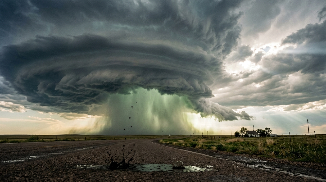
1. Opening Scene: The Prelude to the Deluge
The late-afternoon air across the open plains settles into a stifling, breathless stagnation. The mercury hovers near thirty-four degrees Celsius, and the relative humidity coats the skin in a persistent sheen of perspiration. Insects that buzzed frantically in the roadside grasses fall abruptly silent. Overhead, the sun is swallowed not by a uniform gray overcast, but by a towering, striated anvil of cirrus and dense cumulonimbus that spreads across the sky like an expanding volcanic plume, casting an eerie, bruised-ochre twilight across the landscape.
You feel the change before you see the precipitation. The ambient atmospheric pressure begins a subtle, rhythmic flutter—an internal ear-popping sensation familiar to anyone who has rapidly descended in an elevator. Then comes the scent: an intense, earthy wave of petrichor, the release of geosmin and plant oils aerosolized as distant raindrops hit sun-baked loam miles upwind. The horizon to the northwest turns a deep, bruised cyan—a spectral signature known to seasoned storm spotters as the "green vault," where sunlight is scattered through billions of suspended ice particles and dense water droplets.
       STORM-RELATIVE UPPER TROPOSPHERIC FLOW (Westerly, 35 m/s)
  ===================================================================>
                      ___________________________
                     (   EXPANDING ANVIL CANOPY  )
                    (                             )
                   (   [Mesocyclone Core]          )
                  (     / / / /       | | | |       \ \ \ \
                 (     / Hail /       | Rain|        \ Fine \
                (     / Core /        |Curtn|         \Drops \
               (     /_/_/_/          |_|_|_|          \_\_\_ \
  [Inflow] ===> \       ||              ||                ||
  Warm, Moist    \      ||              ||                ||
  Surface Air     \_____||______________||________________||________
                       (A)             (B)               (C)
                    Severe Hail    Torrential Rain   Scattered Monster
                    & Microburst      Curtain            Raindrops
Suddenly, without the herald of a gentle drizzle, a single drop strikes the dry bonnet of your vehicle with a resounding thwack. It is not an ordinary raindrop; it spreads to the diameter of a silver coin, pooling instantly against the warm metal. Several seconds pass in total stillness before another monstrous drop impacts five meters away, then another, striking the dusty soil with the kinetic energy of a falling pebble.
Within ninety seconds, the calm is violently shattered. The wind abruptly veers ninety degrees and roars out of the dark precipitation curtain, plunging the ambient temperature by fifteen degrees Celsius in less than two minutes. The stifling tropical heat is instantly replaced by a glacial, ozone-scented gale. Behind this advancing shelf of cold air, the sky dissolves into a blinding white wall of torrential rain, quickly interspersed with the deafening, machine-gun rattle of golf-ball-sized hail bouncing violently across the tarmac. You have just crossed the thermodynamic and aerodynamic threshold of a supercell’s forward-flank downdraft.
2. What’s Actually Happening: Plain English First
To understand why a severe storm delivers its contents in such an orderly, dramatic sequence—first giant isolated drops, then sudden cold, then blinding rain, and finally hail—we must view the thunderstorm not as a static cloud, but as a colossal, self-organizing thermodynamic engine.
The Great Sorting Machine
Think of a severe supercell thunderstorm as a combination of an industrial smokestack and an agricultural winnowing machine. At the center of the storm lies a powerful, rotating updraft—the mesocyclone. This updraft acts like a vacuum pipe several miles wide, inhaling warm, humid surface air and rocketing it upward into the freezing upper troposphere at speeds often exceeding one hundred miles per hour.
+-------------------------------------------------------------------------+
|                  THE ATMOSPHERIC WINNOWING PROCESS                      |
|                                                                         |
|  Updraft Ejection Point (10–12 km altitude)                             |
|          |                                                              |
|          +---> Giant Hail (Massive, Low Drag)   ==> Plummets Vertically |
|          |                                                              |
|          +---> Monster Drops (Heavy, Fast Fall) ==> Drops Near Core     |
|          |                                                              |
|          +---> Medium Drops (Moderate Drift)    ==> Carried Miles Away  |
|          |                                                              |
|          +---> Fine Mist / Ice (High Drag)      ==> Carried Tens of     |
|                                                     Miles Downwind      |
+-------------------------------------------------------------------------+
As this moist air ascends, it cools, condenses, and freezes, generating a vast spectrum of water droplets, graupel (soft hail), and solid ice stones. In an ordinary, non-rotating garden-variety storm, this heavy accumulation of water simply falls straight back down through the updraft that created it, choking the storm's engine and causing it to dissipate within forty minutes.
A supercell, however, exists in an environment of strong vertical wind shear—meaning winds at higher altitudes blow much faster and from a different direction than winds at the ground. As the updraft reaches the top of the troposphere, these powerful upper-level jet stream winds catch the manufactured precipitation and blow it horizontally downwind into the anvil.
Here is where natural sorting takes place. Imagine standing on a high bridge on a windy day with a bucket containing bowling balls, glass marbles, ping-pong balls, and feathers, and dumping them over the railing simultaneously:
- The bowling balls (analogous to large hailstones) possess tremendous mass relative to their surface area. Gravity dominates them instantly; they fall almost straight down, barely deflected by the crosswind.
- The marbles (large raindrops) fall rapidly but drift slightly downwind before hitting the surface.
- The ping-pong balls (standard raindrops) are carried hundreds of yards downstream before reaching the ground.
- The feathers (fine mist and ice crystals) drift for miles, eventually forming the wispy outer edges of the anvil canopy.
Because the storm is moving across the landscape, an observer standing in its path encounters the outer perimeter of this dispersion pattern first: the widely spaced monster raindrops that managed to fall out of the anvil’s leading edge, followed progressively by the main rain curtain, and finally the dense core of hail and heavy rain closest to the updraft.
The Atmospheric Refrigerator
Why does the temperature plummet so violently right before the heavy rain hits? The answer lies in the physics of evaporation.
Think of how your skin feels when you step out of a swimming pool on a breezy day: even in warm air, the evaporation of water droplets absorbs heat directly from your body, making you shiver. Beneath the anvil of a supercell, the air is initially warm and unsaturated. As rain and melting ice plunge from the storm’s upper levels into this drier air below the cloud base, a fraction of the liquid instantly evaporates into vapor.
Evaporation requires a immense amount of energy—known as the latent heat of vaporization. The falling rain literally robs heat from the surrounding air pocket, cooling it dramatically within seconds. Cold air is significantly denser and heavier than warm air. Chilled by evaporation and physically dragged downward by billions of falling drops (a mechanism called precipitation loading), this refrigerated air mass plummets to the ground at terminal speeds, creating the Forward-Flank Downdraft (FFD). When this dense plume strikes the solid Earth, it cannot penetrate the soil; instead, it spreads out laterally in all directions, surging forward as an aggressive, icy gust front that plows beneath the warm ambient air.
3. The Science: Aerodynamics, Buoyancy, and Vorticity
For those seeking mathematical rigor, the internal dynamics of the forward-flank downdraft can be formulated through two fundamental physical processes: the aerodynamic equilibrium of differential sedimentation and the thermodynamic forcing of negative buoyancy.
Mathematical Derivation 1: Terminal Velocity and Hydrometeor Sorting
When a hydrometeor (a raindrop or hailstone) falls through the atmosphere, it experiences two opposing forces: the downward force of gravity ($F_g$) and the upward aerodynamic drag force ($F_d$).
The gravitational force acting on a spherical hydrometeor of diameter $D$ and liquid water density $\rho_w$ is given by:
$$F_g = m g = \left( \frac{1}{6} \pi D^3 \rho_w \right) g$$
The aerodynamic drag force exerted by the ambient air of density $\rho_a$ on the particle's cross-sectional area $A = \frac{1}{4} \pi D^2$ is governed by the classical Rayleigh drag equation:
$$F_d = \frac{1}{2} \rho_a v^2 C_d A = \frac{1}{8} \pi \rho_a v^2 C_d D^2$$
where $C_d$ is the dimensionless drag coefficient (approximately $0.45$ to $0.60$ for turbulent flow around turbulent spheres or distorted oblate drops), and $v$ is the vertical fall speed. Terminal velocity ($v_t$) occurs when the net vertical force is zero ($F_g = F_d$):
$$\frac{1}{6} \pi D^3 \rho_w g = \frac{1}{8} \pi \rho_a v_t^2 C_d D^2$$
Solving directly for the terminal velocity $v_t$ yields:
$$v_t(D) = \sqrt{\frac{4 \rho_w g D}{3 \rho_a C_d}}$$
================================================================================
CRITICAL DERIVATION RESULT: THE SEDIMENTATION SCALING LAW
$$v_t \propto \sqrt{D}$$
Terminal fall velocity scales strictly with the square root of particle diameter.
Larger diameters yield dramatically faster descent rates, dictating spatial sorting
under cross-flow advection.
================================================================================
Worked Example: The Size-Sorting Trajectory
Consider a supercell where hydrometeors are exhausted horizontally from the mesocyclone anvil at an altitude $z = 9{,}000\text{ m}$ ($9\text{ km}$) above ground level. Suppose the upper-tropospheric storm-relative wind speed is $u_{sr} = 30\text{ m/s}$ (directed eastward). We evaluate two distinct hydrometeors:
- Particle A (Standard Raindrop): $D_A = 1.0\text{ mm} = 1.0 \times 10^{-3}\text{ m}$
- Particle B (Monster Raindrop / Small Hail): $D_B = 6.4\text{ mm} = 6.4 \times 10^{-3}\text{ m}$
Taking standard mean air density $\rho_a \approx 0.85\text{ kg/m}^3$ over the fall column, water density $\rho_w = 1{,}000\text{ kg/m}^3$, gravitational acceleration $g = 9.81\text{ m/s}^2$, and an average drag coefficient $C_d \approx 0.50$:
For Particle A ($1.0\text{ mm}$): $$v_{t,A} = \sqrt{\frac{4 \cdot (1000) \cdot (9.81) \cdot (0.001)}{3 \cdot (0.85) \cdot (0.50)}} = \sqrt{\frac{39.24}{1.275}} = \sqrt{30.78} \approx 5.55\text{ m/s}$$
For Particle B ($6.4\text{ mm}$): $$v_{t,B} = \sqrt{\frac{4 \cdot (1000) \cdot (9.81) \cdot (0.0064)}{3 \cdot (0.85) \cdot (0.50)}} = \sqrt{\frac{251.14}{1.275}} = \sqrt{196.97} \approx 14.03\text{ m/s}$$
The total time of flight $t_{fall}$ from release altitude $z$ to the ground is $t_{fall} = \frac{z}{v_t}$. The horizontal downwind displacement $\Delta x$ along the anvil vector is:
$$\Delta x = u_{sr} \cdot t_{fall} = u_{sr} \cdot \left( \frac{z}{v_t} \right)$$
-
Displacement for Particle B (Monster Drop): $$t_{fall,B} = \frac{9{,}000\text{ m}}{14.03\text{ m/s}} \approx 641.5\text{ s} \quad (10.7\text{ min})$$ $$\Delta x_B = 30\text{ m/s} \times 641.5\text{ s} = 19{,}245\text{ m} \approx 19.2\text{ km}$$
-
Displacement for Particle A (Standard Drop): $$t_{fall,A} = \frac{9{,}000\text{ m}}{5.55\text{ m/s}} \approx 1{,}621.6\text{ s} \quad (27.0\text{ min})$$ $$\Delta x_A = 30\text{ m/s} \times 1{,}621.6\text{ s} = 48{,}648\text{ m} \approx 48.6\text{ km}$$
The physical outcome is absolute: the standard raindrop is swept nearly thirty kilometers further downwind than the monster drop. As the storm translates across the terrain, an observer stationed along the track inevitably encounters the rapidly sedimenting large drops and hail stones close to the main updraft core, while the smaller drops are dispersed over an expansive forward anvil shield.
Mathematical Derivation 2: Thermodynamic Driving Forces of the Downdraft
The descent of the Forward-Flank Downdraft is driven by the vertical momentum equation for convective parcels. The vertical acceleration $\frac{dw}{dt}$ is governed by thermal buoyancy perturbations and hydrometeor mass loading:
$$\frac{dw}{dt} = g \left( \frac{\theta_v - \bar{\theta}_v}{\bar{\theta}_v} \right) - g q_L$$
where: * $\theta_v$ is the virtual potential temperature of the descending air parcel. * $\bar{\theta}_v$ is the virtual potential temperature of the ambient environmental air at the same pressure level. * $q_L$ is the liquid/solid hydrometeor mixing ratio (mass of condensate per unit mass of dry air, in $\text{kg/kg}$).
================================================================================
THE DOWNDRAFT MOMENTUM EQUATION
$$\frac{dw}{dt} = \underbrace{g \left( \frac{\theta_v - \bar{\theta}_v}{\bar{\theta}_v} \right)}_{\text{Evaporative Cooling Buoyancy Term}} - \underbrace{g q_L}_{\text{Condensate Mass Loading}}$$
================================================================================
The thermal deficit $(\theta_v - \bar{\theta}v)$ is primarily generated by the sub-cloud evaporative cooling rate, which is coupled to the saturation vapor deficit $(q{vs} - q_v)$ and the latent heat of vaporization $L_v \approx 2.5 \times 10^6\text{ J/kg}$:
$$\frac{dT}{dt} \approx -\frac{L_v}{c_p} \left( \frac{dq_v}{dt} \right)_{evap}$$
where $c_p \approx 1005\text{ J/(kg}\cdot\text{K)}$ is the specific heat of dry air at constant pressure.
Worked Example: Downdraft Parcel Acceleration
Consider a sub-cloud parcel at an altitude of $2{,}000\text{ m}$ encountering the dense precipitation curtain: 1. Intense evaporation cools the parcel such that its virtual temperature drops by $\Delta \theta_v = (\theta_v - \bar{\theta}_v) = -6.0\text{ K}$, where the ambient environmental temperature is $\bar{\theta}_v = 300.0\text{ K}$. 2. The local precipitation core sustains a heavy liquid water mixing ratio $q_L = 0.008\text{ kg/kg}$ ($8\text{ grams of water per kilogram of air}$).
We compute the immediate downward acceleration $\frac{dw}{dt}$:
$$\text{Thermal Buoyancy Acceleration} = 9.81 \times \left( \frac{-6.0}{300.0} \right) = 9.81 \times (-0.020) = -0.1962\text{ m/s}^2$$
$$\text{Precipitation Loading Acceleration} = -9.81 \times 0.008 = -0.0785\text{ m/s}^2$$
$$\text{Total Downward Acceleration } \frac{dw}{dt} = -0.1962 - 0.0785 = -0.2747\text{ m/s}^2$$
If this net negative acceleration acts continuously over a vertical descent distance of $\Delta z = 1{,}500\text{ m}$ (assuming an initial downward velocity $w_0 = -2.0\text{ m/s}$ at cloud base), we integrate kinematic velocity:
$$w_f^2 = w_0^2 + 2 \left| \frac{dw}{dt} \right| \Delta z$$ $$w_f^2 = (-2.0)^2 + 2 \cdot (0.2747) \cdot (1500) = 4.0 + 824.1 = 828.1\text{ m}^2/\text{s}^2$$ $$w_f = -\sqrt{828.1} \approx -28.78\text{ m/s} \quad (\approx -103.6\text{ km/h} \text{ or } -64.4\text{ mph})$$
This demonstrates how modest thermal deficits and water loading convert potential energy into an extreme, ground-crashing downdraft that diverges violently upon surface impact.
       BAROCLINIC VORTICITY GENERATION ALONG THE GUST FRONT

                     Warmer Inflow Air (\theta_{v, warm})
                               ^
                               |  Updraft Ingestion
              =================|===================>
             /                 |                    \
            /    ( + \omega_h )|                     \
           /       Roll Axis   |                      \
  <-------+--------------------+-----------------------+------ [Surface]
          |<-- Dense, Cold Outflow (\theta_{v, cold})  |
          |                                            |
     [Gust Front]                        [Precipitation Core]
     \nabla \theta_v Points Right --->
     Horizontal Baroclinic Torque (\nabla \theta_v \times \vec{k}) Generates
     Horizontal Vorticity Vectors (\omega_h) Tilted Upright by Mesocyclone!
Baroclinic Vorticity Generation
This cold outflow does not merely cool the ground; it acts as a critical dynamical catalyst for the supercell itself. Across the leading edge of the forward-flank downdraft, there exists an intense horizontal temperature gradient:
$$\nabla \theta_v = \frac{\partial \theta_v}{\partial x} \hat{i}$$
According to the Boussinesq vorticity equation, a horizontal gradient in buoyancy generates horizontal vorticity through baroclinic generation (the torque produced when density surfaces cross pressure surfaces):
$$\frac{\partial \vec{\omega}_h}{\partial t} = \nabla \times (B \hat{k}) = \left( \frac{g}{\bar{\theta}_v} \frac{\partial \theta_v}{\partial x} \right) \hat{j}$$
This creates a rolling horizontal vortex tube along the leading edge of the cold pool. As the storm's central mesocyclone draws this modified boundary-layer air into its powerful updraft, the vertical wind shear and upward velocity gradient tilt this horizontal vorticity tube into the vertical dimension ($\frac{\partial w}{\partial x} \frac{\partial v}{\partial z}$). This dynamic tilting provides the low-level vertical rotation essential for tornadogenesis, linking microscale raindrop evaporation directly to the birth of violent tornadoes according to National Severe Storms Laboratory observational field research.
4. Practical Outdoor Guidance: Field Observation and Safety
Meteorological literacy transforms an ominous sky into an open blueprint of physical forces. When severe convective storms are active in your region, monitoring sensory cues and portable barometric instruments allows you to accurately pinpoint your position relative to the storm’s hazardous architecture.
1. Visual Sky Signatures: What to Watch For
- The Striated Cloud Base & Green Vault: If the clouds above you exhibit smooth, terraced striations like an amphitheater, you are viewing the base of a rotating mesocyclone. If the precipitation curtain behind the gust front turns an emerald-green or turquoise hue, deep internal scattering indicates a substantial core of severe hail (typically $>2.5\text{ cm}$ diameter) suspended aloft.
- Precipitation Curtain Sharpness: A fuzzy, diffuse rain curtain indicates uniform, small-drop sedimentation. A hard, razor-sharp, opaque boundary resembling a solid gray cliff signifies an extreme concentration of massive drops and hail descending within an intense downburst core.
- The Arcus / Shelf Cloud: A low, horizontal, wedge-shaped cloud line that appears to roll forward indicates the leading edge of the cold pool gust front. If the cloud exhibits rapid upward scudding motions along its leading lip, the downdraft outflow is vigorously displacing warm, buoyant ambient air.
2. Instrumental Indicators: The Surface Micro-Network
If you carry an altimeter watch, outdoor barometer, or mobile weather station, observe the following classic signature:
| Instrument | Phase 1: Inflow Sector | Phase 2: Gust Front Passage | Phase 3: FFD Core Impact |
|---|---|---|---|
| Barometer | Steady, rapid drop (Mesolow) | Sudden sharp spike upwards of $2\text{--}4\text{ hPa}$ (Thunderstorm Wake "Mesohigh") | Erratic fluctuations with high-frequency pressure noise |
| Thermometer | Warm, elevated wet-bulb ($28\text{--}35^\circ\text{C}$) | Plunge of $8\text{--}15^\circ\text{C}$ within $120\text{ seconds}$ | Stable cold pool baseline ($16\text{--}20^\circ\text{C}$) |
| Anemometer | Gentle, sustained inflow toward the storm ($5\text{--}10\text{ m/s}$) | Sudden violent reversal/veer away from precipitation ($15\text{--}30+\text{ m/s}$) | Sustained extreme gusts with turbulent microburst spikes |
TYPICAL BAROMETRIC & THERMAL TRACE DURING FFD PASSAGE
Pressure (hPa)                                         Temp (°C)
1012 |                                                 | 34°
1010 |                 /---\  <-- Gust Surge Mesohigh  | 30°
1008 |                /     \                          | 26°  \
1006 | \             /       \                         | 22°   \ <-- Thermal
1004 |  \___________/         \                        | 18°    \____ Plunge
     +-----------------------------------------> Time  +------------------->
3. Clear Field Rules for Hikers, Sailors, and Gardeners
- The "Five-Drop" Aerodynamic Rule: If you are outdoors under an encroaching severe storm and experience widely scattered, massive, coin-sized raindrops on dry ground, you are standing directly downwind of the hail core. You have between three and seven minutes before the gust front and blinding precipitation envelop your position. Seek substantial shelter immediately; do not wait for the onset of continuous rain.
- The Sailor's Wind-Shift Vector: For mariners on open water, an approaching FFD presents catastrophic squall hazards. If the ambient surface breeze suddenly dies while the sky ahead darkens, the storm is choking your inflow. When the gust front arrives, the wind will not gradually build; it will impact with gale-to-storm force from the direction of the rain curtain. Drop canvas or motor toward safe harbor perpendicular to the advancing shelf cloud.
- The Gardener's Evaporative Check: If the ambient dew point is low (dry air at the surface) while storms are building aloft, the potential for destructive downbursts is magnified. Greater saturation deficits drive higher evaporative cooling rates, transforming an ordinary rain shower into a high-momentum microburst.
For comprehensive real-time convective alerts and severe storm forecasting protocols, consult the World Meteorological Organization (WMO) or national services such as the National Oceanic and Atmospheric Administration (NOAA).
5. Today's Meteorological Rule of Thumb
"Monster drops on dry soil warn of the frozen core behind: when big raindrops fall far apart, the sky's heavy artillery is less than five minutes away."
Whenever you encounter widely spaced, thumb-sized drops that shatter against the pavement during warm weather, remember the sedimentation equation: those heavy hydrometeors fell first because their terminal velocity outran the storm's exhaust winds. The cold, evaporatively driven plunge of the forward-flank downdraft is already on your doorstep.