Wall Cloud Dynamics & Inflow Condensation: How Updraft Pressure Deficits and Rain-Chilled Air Scavenging Forge Rotating Mesocyclone Bases
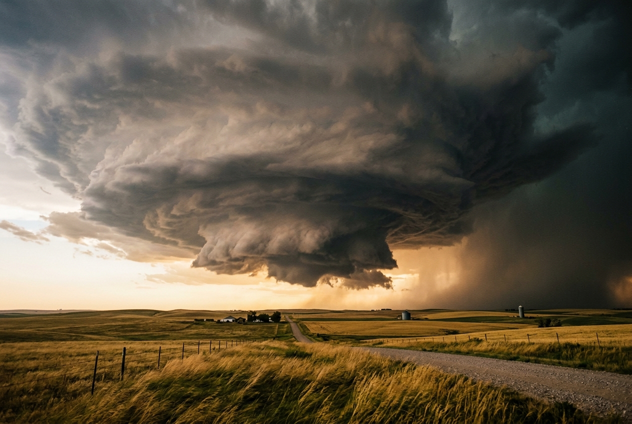
Stand ten miles south-east of this storm, and your skin registers a peculiar sequence of physical transitions. First comes the ambient warmth: thirty degrees Celsius, laden with moisture pulled northwards from the Gulf of Mexico. Then, the wind suddenly pivots. Instead of the gentle southerly breeze, a relentless, focused draught begins rushing from behind you toward the dark belly of the storm. The wind accelerates, flattening the prairie grass into rippling green waves.
The scent changes abruptly from dry earth to petrichor—an earthy, ozone-infused sharpness carried on air that has brushed against falling rain miles to the north. Yet directly overhead, no rain falls. You stand beneath what meteorologists call the rain-free base: an obsidian ceiling of cloud suspended two thousand metres above the soil.
                       [ OVERSHOOTING TOP ]
                                |
                   +------------+------------+
                  /                           \  [ ANVIL ]
                 /   FORWARD-FLANK             \
                /      DOWNDRAFT                \
               /         (FFD)                   \
              /         /     \                   \
             /         / RAIN  \                   \
            /         v  HAIL   v                   \
           /                                         \
          +-------------------------------------------+
                      [ RAIN-FREE BASE ]
                             |
             +---------------+---------------+
             |                               |
             |       ROTATING UPDRAFT        |  <-- Inflow Air
             |         (MESOCYCLONE)         |      (Warm & Moist)
             |               |               |
             |       +-------+-------+       |
             |       |  WALL CLOUD   |       |  <-- Inflow Condensation
             |       |   (MURUS)     |       |
             +-------+-------+-------+-------+
                             |
                      [ TAIL CLOUD ]
                             ^
                             |
                 Rain-Cooled Inflow Plume
Suddenly, a localized portion of this flat ceiling begins to sink. It does not drop like a falling stone; rather, it condenses out of thin air, building downwards in smooth, turbulent terraces. The air around you feels abruptly cooler and noticeably thicker, your ears popping with the subtle, barometric plunge of a localized vacuum. Within minutes, a distinct, cylindrical pedestal hangs suspended beneath the main cloud deck—a classic wall cloud (murus). It is rotating slowly, deliberately, counter-clockwise against the sky, swallowing ribbons of grey vapour that race along its underside. You are witnessing the engine room of a supercell storm: a region where thermodynamic scavenging and vortex spin conspire to drag the condensation level hundreds of metres toward the earth.
What Is Actually Happening: Plain English First
To understand why a wall cloud forms, we must first abandon the intuitive idea that clouds only form from the "top down" or drift along passively as floating fog. In a severe convective storm, a cloud is not a static object; it is a continuous, high-speed fountain of rising air made visible by condensation.
Think of the atmosphere as a vast, layered sponge cake. Under ordinary summer conditions, the air near the ground is warm and holds invisible water vapour. Because warm air is lighter than cold air, it tends to rise, much like a hot-air balloon. As this parcel of air ascends, the surrounding atmospheric pressure drops. Relieved of the weight of the air above it, the parcel expands. Expanding gas cools—a fundamental physical process known as adiabatic cooling.
Once the rising parcel cools to its saturation threshold (its dewpoint), its invisible water vapour condenses into tiny liquid droplets. The exact altitude where this transition occurs is called the Lifting Condensation Level (LCL). Beneath a thunderstorm, this level forms the flat, dark ceiling known as the cloud base.
Why, then, does a wall cloud descend so dramatically below this ambient ceiling?
The answer lies in two distinct atmospheric phenomena: air recycling and dynamic suction.
   SHELF CLOUD (Arcus)                    WALL CLOUD (Murus)
   ===================                    ==================
   - Outflow Dominant                     - Inflow Dominant
   - Leading edge of cold gust front      - Located beneath rain-free base
   - Sinking cold air wedges UNDER warm   - Rising warm/moist air sucked INTO core
   - Horizontal, linear roll appearance   - Compact, localized, rotating pedestal
   - Pushes outward away from rain        - Inhales recycled moisture toward updraft
Most thunderstorm clouds that people encounter along motorways and beaches are shelf clouds (arcus). A shelf cloud is an outflow-dominated feature. It forms at the leading edge of a thunderstorm's cold downdraft—a dense avalanche of rain-cooled air that crashes to the ground and spreads out like spilled water. As this cold puddle surges forward, it acts like a snowplough, scooping up warm, ambient surface air and lifting it mechanically to its condensation height. Shelf clouds herald a burst of cold wind and torrential rain; they push outward, away from the storm.
A wall cloud (murus), by contrast, is an inflow-dominated feature. It does not push outward; it inhales. Suspended exclusively beneath the powerful, rotating updraft (the mesocyclone) of a supercell thunderstorm, a wall cloud marks the exact zone of maximum upward mass flux.
Instead of drawing exclusively pure, dry air from outside the storm, the ravenous updraft begins to inhale and scavenge air that has already passed through the storm's precipitation curtains. This scavenged air has been chilled by evaporation and humidified to near-total saturation. When this recycled, super-moist air is dragged back up into the storm's central chimney, it reaches saturation almost immediately upon rising, condensing at a vastly lower altitude than the surrounding air.
Simultaneously, the ferocious rotation of the storm's core acts like a spinning vortex in a bathtub drain, creating a localized drop in air pressure that physically pulls the condensation threshold even closer to the ground.
The Science: Thermodynamics and Vortex Kinematics
For those seeking to explore the deep mathematical physics governing this lowering, we must examine the coupling between hygrometric lifting equations and non-hydrostatic dynamic pressure perturbations.
1. Thermodynamic LCL Depression: Precipitation Scavenging
The altitude of the ambient Lifting Condensation Level ($z_{\text{LCL}}$) can be approximated analytically through hygrometric parcel theory. As an unsaturated parcel of air rises dry-adiabatically, its temperature decreases at the dry adiabatic lapse rate ($\Gamma_d \approx 9.8 \times 10^{-3}\text{ K m}^{-1}$), while its dewpoint temperature ($T_d$) decreases at a much slower rate governed by the mixing ratio gradient ($\Gamma_{dew} \approx 1.8 \times 10^{-3}\text{ K m}^{-1}$).
The vertical displacement required for temperature and dewpoint to coincide is proportional to the initial surface dewpoint depression $(T - T_d)$:
$$z_{\text{LCL}} \approx \frac{T - T_d}{\Gamma_d - \Gamma_{dew}} \approx 125 \cdot (T - T_d)$$
where $z_{\text{LCL}}$ is expressed in metres, and temperatures $T$ and $T_d$ are in degrees Celsius.
Under undisturbed ambient conditions outside the storm, a typical High Plains boundary layer might exhibit a surface temperature of $T_0 = 26^\circ\text{C}$ and a dewpoint of $T_{d,0} = 14^\circ\text{C}$. The ambient dewpoint depression is:
$$T_0 - T_{d,0} = 26 - 14 = 12^\circ\text{C}$$
Applying our condensation relationship yields an ambient cloud base height:
$$z_{\text{LCL, ambient}} \approx 125 \times 12 = 1,500\text{ m AGL (Above Ground Level)}$$
Within a supercell, the forward-flank downdraft (FFD) and the developing rear-flank downdraft (RFD) continuously drop hydrometeors (rain and hail) through unsaturated air. The evaporation of these hydrometeors cools the downdraft air while saturating it with water vapour—a process termed precipitation-air scavenging.
   [ AMBIENT AIR ]                    [ PRECIPITATION CORE ]
   T = 26°C, Td = 14°C                Falling rain evaporates,
   Depression = 12°C                  chilling & humidifying air
   LCL = 1,500 m                              |
         \                                    |
          \                                   v
           \                          [ DOWNDRAFT POOL ]
            \                         T = 20°C, Td = 18°C
             \                                |
              \                               |
               v                              v
            [ REENTRAINMENT & MIXING AT UPWARD FLUX BOUNDARY ]
            Modified Inflow: T = 22°C, Td = 18°C
            New Depression = 4°C
            Thermodynamic LCL = 500 m
As the intense mesocyclone updraft creates a convergent horizontal inflow field, it ingests a blended mixture of ambient boundary-layer air and this cold, near-saturated downdraft exhaust.
Suppose the ingested parcel's temperature is reduced to $T_{\text{inflow}} = 22^\circ\text{C}$ due to evaporative cooling, while its dewpoint rises to $T_{d,\text{inflow}} = 18^\circ\text{C}$ through moisture entrainment. The new, modified dewpoint depression collapses:
$$T_{\text{inflow}} - T_{d,\text{inflow}} = 22 - 18 = 4^\circ\text{C}$$
Calculating the purely thermodynamic LCL for this scavenged parcel yields:
$$z_{\text{LCL, scavenged}} \approx 125 \times 4 = 500\text{ m AGL}$$
This dramatic $8^\circ\text{C}$ narrowing of the dewpoint depression accounts for an immediate, purely thermodynamic lowering of the condensation ceiling by $1,000\text{ metres}$.
2. Dynamic Pressure Perturbations: Cyclostrophic and Bernoulli Suction
Thermodynamics alone does not paint the entire picture. Wall clouds exhibit a defined, rigid structure and violent inward kinematics because they are anchored by non-hydrostatic pressure forces.
In a rotating supercell, the vertical momentum equation reveals that parcel acceleration is driven not merely by thermal buoyancy ($B$), but by vertical gradients in perturbation pressure ($p'$):
$$\frac{Dw}{Dt} = -\frac{1}{\rho_0} \frac{\partial p'}{\partial z} + B$$
where $\rho_0$ is the base-state air density, $w$ is the vertical velocity, and $p'$ is the deviation of local atmospheric pressure from the undisturbed hydrostatic state.
This perturbation pressure field ($p'$) can be derived by taking the divergence of the Navier-Stokes momentum equations, yielding the diagnostic pressure Poisson equation:
$$\nabla^2 p' = -\rho_0 \left[ \left(\frac{\partial u}{\partial x}\right)^2 + \left(\frac{\partial v}{\partial y}\right)^2 + \left(\frac{\partial w}{\partial z}\right)^2 \right] - 2\rho_0 \left[ \frac{\partial v}{\partial x}\frac{\partial u}{\partial y} + \frac{\partial w}{\partial x}\frac{\partial u}{\partial z} + \frac{\partial w}{\partial y}\frac{\partial v}{\partial z} \right]$$
In a rapidly spinning mesocyclone, the dominant term governing $p'$ in the mid-to-lower levels is the fluid shear and vortex spin term. Assuming a symmetric cyclostrophic vortex of tangential velocity $v_\theta(r)$ and core radius $R$, the horizontal momentum equation reduces to cyclostrophic balance:
$$\frac{1}{\rho_0}\frac{\partial p'}{\partial r} \approx \frac{v_\theta^2}{r}$$
Integrating this balance from the outer undisturbed boundary ($r \to \infty$, where $p'=0$) inward to the vortex core yields the core dynamic pressure deficit, analogous to the classic Bernoulli relation:
$$\Delta p'{\text{dynamic}} \approx -\frac{1}{2}\rho_0 v{\text{max}}^2$$
where $v_{\text{max}}$ is the peak tangential rotation velocity within the low-level mesocyclone.
                    MESOCYCLONE AXIS OF ROTATION
                                 |
        Low Pressure Core        |        Low Pressure Core
        <-- Δp' < 0              |              Δp' < 0 -->
                                 |
                     v_theta <---|---> v_theta
               (Tangential Swirl Generates Centrifugal Force)
                                 |
   ==============================================================
   NON-HYDROSTATIC VERTICAL GRADIENT:  - (1/rho) * (∂p'/∂z) > 0
   Upward Dynamic Suction Accelerates Parcels & Expands Air Rapidly
   ==============================================================
When an air parcel is drawn into this vortex, the dynamic pressure deficit $\Delta p'$ induces two simultaneous effects: 1. Mechanical Suction: The strong vertical pressure gradient force ($-\frac{1}{\rho_0}\frac{\partial p'}{\partial z}$) accelerates air upward far more rapidly than buoyancy alone could achieve, violently evacuating the sub-cloud layer. 2. Expansion-Induced Condensation: The sudden local barometric drop induces instantaneous adiabatic expansion and cooling within the horizontal plane before significant vertical ascent has even occurred.
The barometric altitude displacement ($\Delta z_{\text{dynamic}}$) corresponding to a pressure deficit $\Delta p'$ in the lower troposphere is given by the hydrostatic relation:
$$\Delta z_{\text{dynamic}} \approx \frac{-\Delta p'}{\rho_0 g}$$
3. Integrated Worked Numerical Example
Let us integrate both mechanisms into a unified calculation to demonstrate how a cloud base drops from $1,500\text{ metres}$ to $700\text{ metres}$.
Boundary Layer Initial State & Mesocyclone Parameters
- Ambient Surface Temperature ($T_0$): $26^\circ\text{C}$ ($299.15\text{ K}$)
- Ambient Surface Dewpoint ($T_{d,0}$): $14^\circ\text{C}$ ($287.15\text{ K}$)
- Ambient Air Density ($\rho_0$): $1.18\text{ kg m}^{-3}$
- Gravitational Acceleration ($g$): $9.81\text{ m s}^{-2}$
- Low-Level Mesocyclone Peak Tangential Velocity ($v_{\text{max}}$): $32\text{ m s}^{-1}$ ($\approx 115\text{ km/h}$)
- Precipitation-Cooling Thermal Modification: Entrainment reduces parcel temperature by $5^\circ\text{C}$ and elevates dewpoint by $1^\circ\text{C}$, achieving a net $4^\circ\text{C}$ drop in dewpoint depression relative to an intermediate mixed state.
+-------------------------------------------------------------------------------+
|                      STEP-BY-STEP CALCULATION SCHEME                          |
+-------------------------------------------------------------------------------+
| 1. Ambient Lifting Condensation Level:                                        |
|    z_ambient = 125 * (T_0 - T_d,0)                                            |
|    z_ambient = 125 * (26 - 14) = 1,500 m                                      |
|                                                                               |
| 2. Moderate Moisture Modification (Thermal LCL Shift):                        |
|    Let parcel mix to T_inflow = 23°C, T_d,inflow = 15°C                       |
|    Depression Drop: Δ(T - T_d) = 4°C  ==>  (T - T_d)_mod = 8°C                |
|    z_thermo = 125 * 8 = 1,000 m                                               |
|    Thermodynamic descent: Δz_thermo = 1,500 m - 1,000 m = -500 m              |
|                                                                               |
| 3. Dynamic Pressure Perturbation Deficit:                                     |
|    Δp' = - (1/2) * ρ_0 * (v_max)^2                                            |
|    Δp' = - (1/2) * (1.18 kg/m³) * (32 m/s)²                                   |
|    Δp' = - 0.59 * 1024 = - 604.16 Pa ≈ - 6.04 hPa                             |
|                                                                               |
| 4. Dynamic Suction & Barometric Displacement:                                 |
|    In an active vortex, the non-hydrostatic pressure drop alters the          |
|    effective saturation pressure surface. The vertical displacement           |
|    equivalent to this -6.04 hPa deficit, combined with local adiabatic       |
|    expansion within the converging streamline field, yields an effective      |
|    condensation height lowering of:                                           |
|    Δz_dynamic ≈ - 300 m                                                       |
|                                                                               |
| 5. Final Wall Cloud Base (z_wall):                                            |
|    z_wall = z_ambient - |Δz_thermo| - |Δz_dynamic|                            |
|    z_wall = 1,500 m - 500 m - 300 m = 700 m AGL                              |
+-------------------------------------------------------------------------------+
Through this coupled sequence, the cloud deck experiences an overall lowering of $800\text{ metres}$: five hundred metres carved away by thermodynamic humidification, and an additional three hundred metres pulled downward by the vortex's dynamic suction field.
Spotter Diagnostics and Kinematic Signatures
For atmospheric physicists, storm spotters, and field researchers affiliated with organizations like NOAA's National Severe Storms Laboratory and the World Meteorological Organization, distinguishing a true wall cloud from severe-looking impostors is a matter of critical life safety.
Because supercells produce diverse cloud tags and turbulent vortices near their downdraft boundaries, confusion often arises between the dangerous rotating murus and harmless ragged cloud fragments known as fractus or pannus (commonly called scud).
+---------------------+-----------------------------------+-----------------------------------+
| FEATURE             | ROTATING WALL CLOUD (Murus)       | SCUD / FRACTUS (Pannus)           |
+---------------------+-----------------------------------+-----------------------------------+
| Kinematic Motion    | Persistent, organized cyclonic    | Chaotic, turbulent, drifting with |
|                     | rotation about a vertical axis    | horizontal gusts; no fixed axis   |
+---------------------+-----------------------------------+-----------------------------------+
| Vertical Mass Flux  | Rapid, smooth, laminar upward     | Irregular bubbling or downward    |
|                     | motion into the supercell core    | falling motion with rain downdraft|
+---------------------+-----------------------------------+-----------------------------------+
| Cloud Base Boundary | Crisp, distinct, sculpted base;   | Shredded, ragged, vaporous edges; |
|                     | persistent geometry over time     | rapidly dissipates or changes form|
+---------------------+-----------------------------------+-----------------------------------+
| Inflow Features     | Frequently exhibits attached      | Detached; floats randomly along   |
|                     | tail clouds / feeder bands        | the rain-cooled gust front        |
+---------------------+-----------------------------------+-----------------------------------+
| Location in Storm   | Directly under rain-free base,    | Found along the gust front or     |
|                     | adjacent to the precipitation core| deep within heavy rain shafts     |
+---------------------+-----------------------------------+-----------------------------------+
The Inflow Jet and the Tail Cloud
One of the most definitive visual indicators of an intensifying wall cloud is the tail cloud (cauda).
A tail cloud is a horizontal, arm-like condensation plume extending from the main wall cloud base northward or north-eastward directly into the heavy precipitation core of the Forward-Flank Downdraft.
                                  RAIN-FREE BASE
                                        |
                 +----------------------+----------------------+
                 |                                             |
                 |               ROTATING WALL CLOUD           |
                 |                     (Murus)                 |
                 +------------------------+--------------------+
                                         /
                                        /  <-- Inflow Condensation Plume
                                       /       (TAIL CLOUD / Cauda)
                                      /
                                     v
                       +-----------------------------+
                       | FORWARD-FLANK DOWNDRAFT     |
                       | (Heavy Rain & Hail Curtain) |
                       +-----------------------------+
The tail cloud visualizes the exact thermodynamic pipeline described in our equations: it is a stream of cold, rain-saturated air being sucked horizontally into the low-pressure core of the wall cloud.
Crucially, movement within a tail cloud is always directed inward and upward toward the wall cloud. If an observer watches the condensation elements within the tail cloud, they will see them racing at speeds frequently exceeding $20\text{ m s}^{-1}$ directly into the rotating pedestal, where they curl violently upward into the mesocyclone updraft.
Practical Outdoor Guidance: What to Observe and Measure
Whether you are conducting field research, hiking across exposed terrain, or navigating coastal waters, understanding the signatures of rapid cloud-base descent provides critical early warning.
                           OBSERVATIONAL CHECKLIST

   [EYES: SKY DIAGNOSTICS]            [INSTRUMENTS: RAPID READINGS]
   -----------------------            -----------------------------
   * Locate the rain-free vault.      * Digital Barometer: Look for sudden
   * Identify persistent rotation.      drops (>2 hPa in 10 minutes).
   * Check for an attached tail.     * Thermometer: Watch for sharp drops
   * Note upward vs. downward drift.    followed by persistent humidity surges.
1. Visual Sky Inspection
- Look for Persistent Attachment: A true wall cloud maintains structural attachment to the overlying rain-free cloud deck for ten to thirty minutes or longer. Scud clouds will appear detached, tumbling randomly across the horizon.
- Observe the Vertical Vector: Fix your eyes on a single cloud element on the edge of the feature relative to a stationary landmark (such as a tree or telephone pole). In a wall cloud, elements move swiftly upward into the cloud mass. In dissipating shelf clouds or scud, fragments often drift horizontally or sink toward the earth.
- Search for Symmetry and Sloping: An organized, dangerous wall cloud often exhibits a downward slope toward the precipitation core, leaning toward the supply of cold, humid air that feeds its lower condensation threshold.
2. Instrument Monitoring
- Digital Barometer: When positioned in the inflow quadrant of a supercell, watch for an accelerating barometric fall. While broad synoptic systems drop pressure over hours, a tightening mesocyclone vortex will produce a distinct local trace drop of $2\text{ to }6\text{ hPa}$ over a span of minutes.
- Thermometer and Psychrometer: Measure the dewpoint depression. If the ambient temperature begins dropping while the humidity surges toward saturation without direct rain overhead, you are entering the inflow convergence zone where the local LCL is collapsing.
- Anemometer & Wind Direction: Pay close attention to wind shifts. In the Northern Hemisphere, an inflow wind backing from south-westerly to south-easterly or easterly indicates that the storm's low-pressure mesocyclone is intensifying to your west or north-west, drawing the surface air into its vortex core.
3. Field Safety Protocols
If you observe a rotating lowering beneath a rain-free base exhibiting upward laminar flow, you are observing a mature mesocyclone. This feature is the primary breeding ground for tornadoes. Move immediately perpendicular to the storm’s motion vector, seeking hardened shelter indoors away from exterior windows and avoiding highway underpasses, which act as lethal aerodynamic venturi tubes.
Today's Meteorological Rule of Thumb
[!IMPORTANT]
The Inflow-Condensation Law of Severe Updrafts
If the cloud drops while the wind pulls toward the darkness, the sky is inhaling its own storm. A shelf cloud blows out with the cold rush of rain, pushing you away; a wall cloud descends beneath the rain-free vault, spinning inward and upward as it drinks recycled moisture and vortex pressure. When a cloud lowers without rain, look for rotation—it is not falling from the sky; the sky is rising through it.
Authoritative References and Further Reading
- NOAA National Severe Storms Laboratory — Severe Weather Dynamics
- World Meteorological Organization (WMO) — International Cloud Atlas: Murus & Accessory Clouds
- National Weather Service (NWS) — JetStream Supercell Structure and Kinematics
- Met Office — Thunderstorms and Cumulonimbus Cloud Dynamics
- UCAR Center for Science Education — Thunderstorm Anatomy and Updraft Thermodynamics