Updraft Helicity (UH) & Severe Storm Swath Dynamics: How Vertical Vorticity Integration Pinpoints Mesocyclone Tracks and Tornadic Corridors
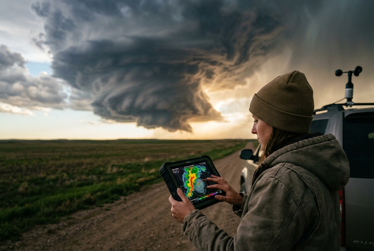
1. Opening Scene: The Living Column
On an early June late afternoon across the high plains of western Kansas, the atmosphere ceases to be an invisible medium and becomes a tangible, predatory architecture. The ambient air at ground level is uncomfortably warm and soupy, laden with moisture hauled north from the Gulf of Mexico. Stand on the gravel verge of an empty county road, and you feel the wind tugging persistently at your back—a stiff, warm southeasterly gale blowing directly toward the western horizon. The scent of sun-baked wheat and dry prairie topsoil is abruptly sliced by the sharp, metallic tang of ozone and chilled rainwater evaporating high above.
       [ ANVIL STRATIFORM CANOPY ]
                  \
                   \   (Overshooting Top)
                    \      _.-''''-._
                     \   .'          `.
                      \ /   UPDRAFT    \
                       :    HELICITY    :  <--- 2 to 5 km AGL
     MID-LEVEL SPIN    |   ROTATING     |       (Mid-Level Mesocyclone)
       ( ζ_z > 0 )     :    COLUMN     ;
                        \  ( w >> 0 )  /
     ====================`._        _.'==========================
     WARM INFLOW JET =====>  `'----'`  <===== RFD CLEAR-SLOT
     (Backing surface winds)  / Wall \        (Descending downdraft)
                             / Cloud  \
                            /__________\
Above you, what began an hour ago as innocent, cauliflower-like cumulus towers has merged and violently erupted into a monolithic supercell. The western sky is swallowed by a towering anvil of cirrus that blots out the sun, casting the landscape into a bruised, twilight hue of turquoise and slate. Your eardrums pop—a subtle, physical reaction to the steepening local barometric gradient as the storm’s mesolow deepens.
As you look up into the heart of the storm’s base, there is no chaotic churn; instead, there is terrifying order. The cloud base is sculpted into a smooth, inverted bell—a tiered, striated pedestal that resembles a colossal barbershop pole suspended from the stratosphere. Striations carved into the cloud flanks corkscrew upward in a relentless counter-clockwise spiral. Low-hanging cloud fragments, ragged and dark, race along an invisible highway from the east, feeding smoothly into the base before twisting vertically at dizzying speeds. To the southwest edge of this rotating cylinder, a dramatic notch of crystal-clear air bites into the rain curtain—the rear-flank downdraft carving a pristine slot through the gloom. There is no thunderclap yet, only a continuous, low-frequency rumble vibrating through the soles of your boots: the acoustic roar of millions of tons of air being accelerated upward and set into violent, coherent rotation.
2. What's Actually Happening — Plain English First
To understand why a supercell storm can organize itself into such a self-sustaining atmospheric engine, imagine the atmosphere not as an empty void, but as a vast, layered cake. Each slice of this cake, from the ground up to cruising altitude, possess different temperatures, moisture contents, and wind velocities.
Ordinary summer thunderstorms are relatively simple thermal engines. On a hot day, the sun bakes the earth, which heats the air right above it. Because warm air is lighter and less dense than cold air, it bubbles upward like a hot-air balloon. As this rising bubble ascends, moisture condenses into cloud droplets, releasing latent heat and powering the cloud higher. Eventually, the weight of the condensed rain and hail becomes too heavy for the rising air to support. The precipitation cascades downward, creating a cold, rain-cooled downdraft. In an ordinary thunderstorm, this cold downdraft crashes directly down into the warm updraft, choking off its fuel supply. The storm rains itself out, collapsing within forty-five minutes.
ORDINARY THUNDERSTORM                 ROTATING SUPERCELL (TILTED & SEPARATED)
---------------------                 ----------------------------------------
       [ Updraft ]                                    [ Overshooting Top ]
            |                                                 /
   +--------+--------+                                       / (Anvil)
   |                 |                         Updraft     /
   v                 v                         (Ascent)   /    Downdraft (Precip)
[Rain]             [Rain]                        /       v         |
(Downdraft chokes Updraft)                      /                 v
                                              (Separated: Sustained Engine)
A rotating supercell overcomes this self-destructive flaw through the intervention of vertical wind shear—the change in wind speed and direction as you climb higher in the atmosphere.
Imagine placing a pencil flat on a table between your palms. If you move your top palm forward while keeping your bottom palm stationary, the pencil rolls along the table. In the lower atmosphere, when slow winds at the surface blow from the southeast while fast jetstream winds aloft blow from the southwest, the intervening air is forced to roll into horizontal, invisible tubes of rotating air.
On its own, a horizontal tube of rolling air does not produce a tornado or a rotating storm. But when a powerful, buoyant updraft punches upward through this rolling tube, it snags the middle of the tube and bends it upright. What was once horizontal rolling motion is tilted into two vertical spinning columns. The storm’s internal pressure dynamics amplify the cyclonically spinning half of this column while suppressing the other, transforming the updraft itself into a giant, vertically oriented, spinning vortex known as a mesocyclone.
Because the updraft is now tilted and continuously rotating, the rain and hail are slung outward by centrifugal and steering winds, falling well away from the rising air column. The updraft and downdraft no longer collide; they operate side-by-side in symbiotic balance. The storm is no longer a transient burst of convection, but a quasi-steady-state thermodynamic engine capable of persisting across hundreds of kilometers.
3. The Science: Updraft Helicity and Numerical Swath Dynamics
Mathematical Derivation of Updraft Helicity
In modern dynamic meteorology, quantifying the sheer rotational vigour of a convective updraft requires a kinematic metric that simultaneously measures vertical lift and vertical rotation. This parameter is Updraft Helicity ($UH$).
In classical fluid mechanics, helicity ($H$) measures the alignment between the velocity vector ($\vec{u}$) of a fluid parcel and its vorticity vector ($\vec{\omega} = \nabla \times \vec{u}$), defined as:
$$H = \vec{u} \cdot (\nabla \times \vec{u}) = \vec{u} \cdot \vec{\omega}$$
Helicity is a pseudo-scalar that quantifies the corkscrewing nature of a flow. When applied to convective atmospheric modeling, meteorologists focus on the vertical component of this scalar product within the mid-tropospheric layer of a storm.
Updraft Helicity ($UH$) is defined mathematically as the vertical integral of the product of vertical velocity ($w$) and the vertical component of relative vorticity ($\zeta_z$) between two prescribed vertical boundaries, $z_0$ and $z_1$:
$$UH = \int_{z_0}^{z_1} w \, \zeta_z \, dz$$
Where: * $w = \frac{dz}{dt}$ is the vertical velocity component ($\text{m}\cdot\text{s}^{-1}$). * $\zeta_z = \left(\frac{\partial v}{\partial x} - \frac{\partial u}{\partial y}\right)$ is the vertical component of relative vorticity ($\text{s}^{-1}$), representing local counter-clockwise (cyclonic) or clockwise (anticyclonic) shear and curvature rotation. * $z_0$ and $z_1$ represent the lower and upper integration heights above ground level (AGL). By international meteorological convention established across NOAA Storm Prediction Center diagnostic frameworks, the standard integration depth is set from $z_0 = 2,000\text{ m}$ to $z_1 = 5,000\text{ m}$ (2–5 km AGL). * $dz$ is the incremental vertical distance ($\text{m}$).
=============================================================================
                      DIMENSIONAL ANALYSIS OF UPDRAFT HELICITY
=============================================================================
Variable               Symbol       SI Base Units
-----------------------------------------------------------------------------
Vertical Velocity        w          m · s⁻¹
Vertical Vorticity      ζ_z         s⁻¹
Vertical Increment      dz          m
-----------------------------------------------------------------------------
Integrated Product:     UH = ∫ (w · ζ_z) dz
Units:                  [m · s⁻¹] · [s⁻¹] · [m] = m² · s⁻² (or Joules/kg)
=============================================================================
The resulting dimensional units of Updraft Helicity are $\text{m}^2\cdot\text{s}^{-2}$ (square meters per second squared). Energetically, this is equivalent to specific energy ($\text{J}\cdot\text{kg}^{-1}$), underscoring that $UH$ represents the kinematic concentration of kinetic energy dedicated to helical, rotating ascent.
The Mathematical Filter: Isolating Rotating Cores
The brilliance of the $UH$ integral lies in its multiplicative formulation. It acts as an exclusive mathematical bandpass filter for mesocyclones:
- Pure Buoyancy Without Shear (Pulse Thunderstorms): A tropical pulse storm may feature violent updraft speeds ($w = 40\text{ m}\cdot\text{s}^{-1}$), but in the absence of ambient vertical wind shear, its vertical vorticity is negligible ($\zeta_z \approx 0\text{ s}^{-1}$). The product $w \cdot \zeta_z$ vanishes, yielding $UH \approx 0\text{ m}^2\cdot\text{s}^{-2}$.
- Pure Shear Without Buoyancy (Frontal Shear Zones / Drylines): A tight baroclinic boundary or dryline wave may exhibit fierce horizontal shear and high vertical vorticity ($\zeta_z = 0.015\text{ s}^{-1}$), but if the capping inversion prevents convection ($w \approx 0\text{ m}\cdot\text{s}^{-1}$), the product remains zero.
- Supercell Mesocyclones: Only when intense upward acceleration coincides spatially with rapid vertical rotation does the integral yield large, positive values.
       VERTICAL VELOCITY (w)               VERTICAL VORTICITY (ζ_z)
      [ Upward Blast: m/s ]                [ Cyclonic Spin: 1/s ]
                \                                    /
                 \                                  /
                  \======> [ w · ζ_z ] <===========/
                                 |
                                 v
                       INTEGRATION LAYER
                         (2 to 5 km AGL)
                                 |
                                 v
                     UPDRAFT HELICITY (m²/s²)
          Isolates Supercells from Ordinary Thunderstorms
Worked Numerical Example
To see how this works in practice, let us evaluate the $UH$ integral for two distinct atmospheric columns observed over a 3,000-meter integration depth ($z = 2,000\text{ m}$ to $5,000\text{ m}$ AGL, so $\Delta z = 3,000\text{ m}$). For simplicity in this discrete calculation, we assume mean layer-averaged values:
Case A: Vigorous Non-Rotating Multicell Updraft
- Mean vertical velocity: $\bar{w} = 30\text{ m}\cdot\text{s}^{-1}$
- Mean mid-level vertical vorticity: $\bar{\zeta}_z = 0.0008\text{ s}^{-1}$
- Integration depth: $\Delta z = 3,000\text{ m}$
$$UH_{\text{multicell}} \approx \bar{w} \cdot \bar{\zeta}_z \cdot \Delta z = (30\text{ m}\cdot\text{s}^{-1}) \times (0.0008\text{ s}^{-1}) \times (3,000\text{ m}) = 72\text{ m}^2\cdot\text{s}^{-2}$$
Case B: Violent Great Plains Supercell Mesocyclone
- Mean vertical velocity: $\bar{w} = 45\text{ m}\cdot\text{s}^{-1}$
- Mean mid-level vertical vorticity: $\bar{\zeta}_z = 0.012\text{ s}^{-1}$ (an intense, tightly wound mesocyclone)
- Integration depth: $\Delta z = 3,000\text{ m}$
$$UH_{\text{supercell}} \approx \bar{w} \cdot \bar{\zeta}_z \cdot \Delta z = (45\text{ m}\cdot\text{s}^{-1}) \times (0.012\text{ s}^{-1}) \times (3,000\text{ m}) = 1,620\text{ m}^2\cdot\text{s}^{-2}$$
Case B produces a $UH$ value over twenty times larger than Case A, reflecting the extreme helical concentration of kinetic energy within a tornadic supercell.
Operational Diagnostic Thresholds for 2–5 km Updraft Helicity
- $25 - 50\text{ m}^2\cdot\text{s}^{-2}$ (Marginal / Weak Rotation): Weakly organized multicell clusters or transient, short-lived supercellular structures in marginal shear environments.
- $50 - 100\text{ m}^2\cdot\text{s}^{-2}$ (Moderate Mesocyclone): Well-defined rotating supercell capable of producing severe hail ($\ge 2.5\text{ cm}$) and damaging convective wind gusts.
- $100 - 250\text{ m}^2\cdot\text{s}^{-2}$ (Strong Supercell): Classic supercell with a sustained, intense mesocyclone; elevated risk of significant hail ($\ge 5\text{ cm}$) and tornadoes.
- $> 250\text{ m}^2\cdot\text{s}^{-2}$ (Violent / Tornadic Supercell): High-end, long-track supercellular engine. Extreme likelihood of destructive hail, severe wind damage, and significant or violent tornadogenesis ($EF2 - EF5$).
Convection-Allowing Models (CAMs) and Cumulative UH Swaths
The operational revolution in convective forecasting over the past decade is rooted in Convection-Allowing Models (CAMs). Unlike legacy hydrostatic models that parameterized thunderstorms over 12-to-40 km grids, modern high-resolution models—such as NOAA’s High-Resolution Rapid Refresh (HRRR) and the experimental Warn-on-Forecast System (WoFS) developed by the National Severe Storms Laboratory (NSSL)—operate at grid spacings of 3 km down to sub-kilometer scales.
At these resolutions, CAMs explicitly resolve Navier-Stokes fluid dynamics and non-hydrostatic vertical motions without convective parameterization. Because a simulated supercell traverses multiple grid cells during each model integration timestep, forecasters do not rely solely on instantaneous snapshots of $UH$. Instead, CAMs track the hourly maximum $UH$ realized at each horizontal grid point $(x, y)$:
$$UH_{\text{max}}(x, y) = \max_{t \in [t_0, t_1]} \left[ \int_{2000}^{5000} w(x, y, z, t) \, \zeta_z(x, y, z, t) \, dz \right]$$
TIME STEP 1 (t = 00 min)      TIME STEP 2 (t = 30 min)      TIME STEP 3 (t = 60 min)
   [ (UH = 320) ]                   .                             .
         .                    [ (UH = 410) ]                      .
         .                          .                       [ (UH = 380) ]
-----------------------------------------------------------------------------
HOURLY CUMULATIVE UH SWATH:
   ===================================================================>
   [ Continuous High-Risk Corridor of Sustained Helical Track: 300+ m²/s² ]
When these maximum values are plotted continuously over forecast intervals of 1 to 24 hours, they trace out continuous, elongated "tracks" or UH swaths.
A continuous, straight or gently right-deviating swath of $UH > 150\text{ m}^2\cdot\text{s}^{-2}$ stretching for 200 kilometers indicates a long-lived, steady-state supercell that maintains structural coherence over hours. Conversely, disjointed, short-lived blips signify disorganized, pulse-type convection.
DETERMINISTIC SWATH vs. ENSEMBLE STAMPEDE
-----------------------------------------------------------------------------
Deterministic Track (HRRR Single Run):
[--- Strong Core Path ---------------------------->] (High spatial precision,
                                                      sensitive to initial error)

Ensemble UH Paintball / Stampede (WoFS 18 Members):
      \ \ \  ===   / /
   === \ \ ======= / / ===   (Spatial clustering defines highest conditional
      ======= X =======       probability of mesocyclone tracking through X)
   === / / ======= \ \ ===
To quantify forecast uncertainty, meteorologists employ ensemble UH stampedes and paintball plots. By running an ensemble of 10 to 30 CAM members with slightly perturbed initial thermodynamic conditions (as seen in the Met Office and World Meteorological Organization convective forecasting frameworks), forecasters plot the cumulative $UH$ tracks of all members simultaneously.
Where the individual tracks diverge randomly, forecast confidence in exact storm placement is low. But when dozens of independent ensemble members converge into a dense, tight corridor of overlapping swaths—a "stampede"—forecasters can identify high-risk severe weather and tornado corridors hours before the first convective cloud even forms.
4. Connecting Numerical Tracks to Radar and Ground Truth
The mathematical signature of Updraft Helicity directly mirrors what field observers witness on the ground and what Doppler radars detect in real-time.
=============================================================================
                  TRIPARTITE CONVECTIVE CONVERGENCE
=============================================================================
CAM Forecast Metric      Doppler Radar Signature        Visual Ground Feature
-----------------------------------------------------------------------------
UH: 25–50 m²/s²          Broad, transient shear         Ragged, disorganized
                         (vorticity < 0.004 s⁻¹)        updraft base; tilted shelf
-----------------------------------------------------------------------------
UH: 100–250 m²/s²        Coherent Velocity Couplet      Striated "Barber-Pole"
                         Gate-to-gate shear > 25 m/s    barrel; beaver-tail inflow
-----------------------------------------------------------------------------
UH: > 250 m²/s²          TVS (Tornado Vortex Sig.)      Sculpted bell pedestal;
                         TDS (Tornado Debris Sig.)      RFD clear-slot carving;
                         Deep BWER & Hook Echo          Rapidly rotating wall cloud
=============================================================================
DOPPLER RADAR MESOCYCLONE COUPLET (STORM-RELATIVE VELOCITY)
-----------------------------------------------------------
               RADAR BEAM DIRECTION ===>
                  [  + + + +  ]  <--- Red: Outbound Velocity (Moving Away)
                  [  + + + +  ]
               ( Velocity Couplet )
                  [  - - - -  ]  <--- Green: Inbound Velocity (Moving Toward)
                  [  - - - -  ]
       Tightly packed inbound/outbound gates indicate rotating core.
- The Radar Signature (Doppler Velocity Couplets): When an operational WSR-88D radar scans a region highlighted by high $UH$ swaths, the mesocyclone appears as an adjacent pair of inbound (green) and outbound (red) velocity pixels—a velocity couplet. As the storm ingests horizontal vorticity and tilts it upright, the gate-to-gate azimuthal wind shear intensifies. If the mesocyclone contracts further, a Bounded Weak Echo Region (BWER) and a prominent hook echo wrap around the rotating updraft, culminating in a Tornado Vortex Signature (TVS) and, upon ground contact, a Dual-Polarization Tornado Debris Signature (TDS).
- The Visual Anatomy (Ground Truth):
- Striated Updraft (Barber-Pole Barrel): The corkscrewing motion captured by the $\zeta_z$ term creates distinct, helical laminar bands circling the perimeter of the updraft chimney.
- Inflow Feeder Bands ("Beaver Tails"): Smooth, low-altitude cloud bands streaming into the storm from the east-southeast delineate the ingestion of high equivalent potential temperature ($\theta_e$) boundary-layer air.
- The RFD Clear-Slot: The rear-flank downdraft, accelerated by precipitation loading and evaporative cooling, descends along the back of the mesocyclone. It acts like a giant atmospheric cookie-cutter, carving a crescent of clear blue sky around the rotating wall cloud and focusing vertical vorticity near the ground.
5. Practical Outdoor Guidance
Whether you are an atmospheric scientist in the field, a hiker, a sailor navigating coastal waters, or a gardener monitoring afternoon storm buildups, understanding convective rotation is a critical safety skill.
=============================================================================
                     FIELD OBSERVATION & SAFETY MATRIX
=============================================================================
Observable Element   Indicator of Severe Rotation     Action Required
-----------------------------------------------------------------------------
Visual Cloud Motion  Sustained horizontal movement    Seek immediate sturdy
                     of cloud tags along base;        shelter; do not stay
                     rapid vertical corkscrewing.     in tents or vehicles.
-----------------------------------------------------------------------------
Barometer            Rapid drop (> 2 hPa in 15 min)   Storm mesolow approaching;
                     followed by violent surge.       prepare for severe gusts.
-----------------------------------------------------------------------------
Surface Wind Shift   Wind "backs" from SW to SE/E;    Inflow jet strengthening;
                     abrupt temperature increase.     storm is anchoring/rotating.
-----------------------------------------------------------------------------
Sky Color            Deep turquoise/emerald green     Massive hail core suspended
                     adjacent to dark vault.          aloft; imminent severe hail.
=============================================================================
What to Look for in the Sky
- Persistent Rotation at Cloud Base: Do not just look for funnels. Look at the broader cloud base. If cloud tags (scud) are moving rapidly from left to right on one side and right to left on the other, or if the entire base is visibly turning like a carousel over a 3-to-5 minute window, a mesocyclone is overhead.
- The "Green Vault": A deep, bruised emerald or turquoise coloration within the cloud core is caused by sunlight scattering through massive concentrations of suspended water droplets and large hail within an extraordinarily powerful updraft ($w > 30\text{ m}\cdot\text{s}^{-1}$).
- The Clear-Air Notch: If you see a bright, clear slot opening immediately adjacent to a dark, rain-wrapped wall cloud, the rear-flank downdraft is actively wrapping around the circulation, signaling imminent tornadogenesis.
Instrument Readings to Watch
- Digital Barometer: A slow decline in pressure is normal ahead of a weather front. However, a rapid, steep plunge of $2\text{ to }5\text{ hPa}$ within 15 to 30 minutes, followed by an abrupt pressure jump, marks the passage of a mesolow and gust front.
- Wind Direction (Wind Vane / Anemometer): Watch for "backing" winds. If the wind shifts from westerly or southwesterly to briskly easterly or southeasterly as a storm approaches from the west, the storm is actively drawing surface air into its mesocyclonic vacuum.
The Back-to-the-Wind Rule for Storm Observers
Stand safely with your back to the surface wind. In the Northern Hemisphere, by Buys Ballot’s Law, the lowest atmospheric pressure lies to your left. If you are facing a severe thunderstorm and the warm surface wind is blowing directly into the storm from behind you, you are standing directly in the storm’s primary inflow corridor—the most dangerous sector for large hail and tornadogenesis.
6. Today's Meteorological Rule of Thumb
The Helicity Maxim
"Buoyancy builds the tower, but shear gives it life."
A thunderstorm with extreme heat and moisture alone will quickly drown in its own rain. But when rising air twists through changing winds aloft, the updraft corkscrews into a self-sustaining vortex—turning a fleeting downpour into a long-track supercell.