Significant Tornado Parameter (STP) & Supercell Composite Dynamics: How Kinematic-Thermodynamic Product Scaling Isolates Violent Tornadic Outbreaks
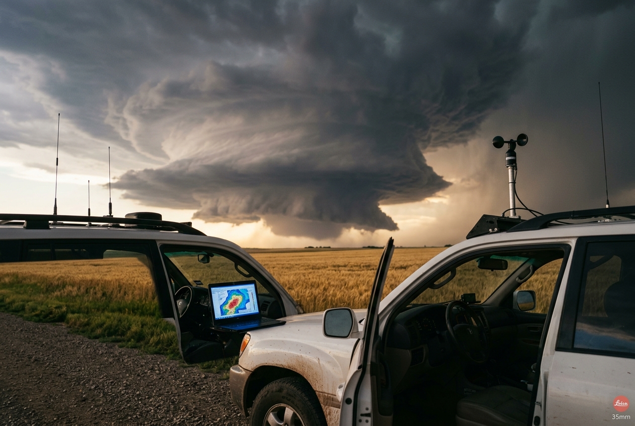
As the sun is obscured by an encroaching anvil canopy that stretches dozens of miles downwind, the temperature undergoes a sharp, contradictory transition. The ambient warmth gives way to a cool, ozone-rich downdraft, carrying the crisp scent of petrichor—the smell of rain striking parched topsoil. Above the horizon, the base of the cloud deck hangs remarkably low, dark as bruised iron. A laminar, striated cloud band known to storm observers as a "beaver tail" extends gracefully into the storm’s core, smoothly drawing warm, moisture-laden inflow into a rotating updraft. To the untrained eye, this is merely a dramatic summer storm. To an atmospheric scientist, it represents a finely tuned thermodynamic engine where vast reservoirs of potential energy are being converted into violent mechanical rotation.
       MID-TO-UPPER TROPOSPHERE (Strong Westerly Flow, 500-250 hPa)
                 =========================================>
                                /                   ^
                               /   UPDRAFT CORE     | (Tilting of
                              /    (Buoyancy /      |  Horizontal
                             /      Dynamic PGF)    |  Vorticity)
                            /                       |
   SURFACE LAYER (Backing SE Winds, 0-1 km High Streamwise Vorticity)
   -----> -----> -----> ------>
1. What Is Actually Happening: Plain English First
To understand why only a tiny fraction of severe thunderstorms produce catastrophic tornadoes, one must discard the common assumption that atmospheric violence is purely a function of raw heat or explosive cloud growth.
Think of the atmosphere as a complex, multi-tiered layer cake. The bottom layer, directly adjacent to the earth's surface, contains the moisture and warmth absorbed from solar heating. If you release a parcel of this warm, moist air, it acts like a hot-air balloon: because it is less dense than the cooler air surrounding it, it accelerates rapidly upward. Meteorologists call this buoyant energy Convective Available Potential Energy (CAPE), catalogued by the National Oceanic and Atmospheric Administration (NOAA).
However, raw buoyant energy alone is insufficient. If a buoyant bubble of air rises in a calm atmosphere with no wind change with height, it goes straight up, condenses into rain, and that heavy rain falls directly back down through the rising air, suffocating the updraft within thirty to forty-five minutes. This is the life cycle of an ordinary "pulse" thunderstorm.
+-------------------------------------------------------------------------+
|                  THE FOUR-INGREDIENT CONVECTIVE MATRIX                  |
+-----------------------------------+-------------------------------------+
| 1. Instability (CAPE)             | Thermal engine powering updraft     |
| 2. Deep-Layer Shear (0-6 km EBWD) | Organizes storm; tilts & sustains   |
| 3. Low-Level Helicity (0-1 km SRH)| Supplies streamwise spin to ingest  |
| 4. Boundary Moisture (Low LCL)    | Keeps downdrafts warm & buoyant     |
+-----------------------------------+-------------------------------------+
To transform an ordinary storm into a persistent, self-sustaining supercell—a storm with a continuously rotating updraft—the atmosphere requires wind shear, which is the change in wind speed and direction with height.
Imagine rolling a pencil along a tabletop under your flat palm. Friction creates horizontal rotation along the table surface. In the atmosphere, slow winds at the ground overlaid by roaring jet stream winds at six kilometres altitude create invisible, horizontally rolling tubes of spinning air.
When a powerful updraft punches through these horizontal tubes, it catches the roll, bends it upward into a vertical orientation, and splits it into rotating columns. If the wind also veers (turns clockwise) with height, the storm ingests pure streamwise vorticity—much like a perfectly spiralled American football cutting through the air—creating a single, intensely rotating convective vortex known as a mesocyclone.
Yet even a violently rotating supercell does not guarantee a tornado at ground level. The true physical bottleneck in severe storm meteorology is tornadogenesis: transferring that mid-level rotation all the way down to the immediate ground surface. If the cloud base is too high, dry ambient air evaporates falling precipitation, chilling the storm's downdraft into an icy, dense outflow pool that rushes outward like a miniature cold front, sweeping away the delicate low-level rotation. Only when the air near the ground is nearly saturated (producing a low cloud base) and low-level wind shear is extraordinarily strong can the storm stretch, concentrate, and anchor that vortex to the earth.
2. The Science: Why Single Parameters Fail
For decades, operational meteorologists attempted to forecast tornadic events using single, isolated indices. Forecasters would evaluate bulk CAPE, or examine the total 0–6 km bulk wind difference. Time and again, these univariate approaches failed in field operations:
- High-CAPE, Low-Shear Failures: On hot Midwestern summer afternoons, CAPE values can exceed an astronomical $4,500\,\text{J}\cdot\text{kg}^{-1}$. Yet in the absence of wind shear, this massive energy produces chaotic "popcorn" multicells that quickly choke on their own outflow.
- High-Shear, Low-CAPE (HSLC) Outbreaks: Conversely, cool-season severe weather setups across the southeastern United States often present with modest CAPE ($500\text{ to }1,000\,\text{J}\cdot\text{kg}^{-1}$), yet produce devastating, long-track violent tornadoes because the low-level wind shear and boundary-layer moisture are off the charts.
Because atmospheric ingredients are multiplicative rather than additive, modern convective forecasting relies on non-dimensional multi-parameter composite scaling, developed extensively by researchers at the NOAA Storm Prediction Center (SPC). These indices scale distinct physical processes against empirically derived climatological baselines, producing unified parameters that capture the non-linear interaction of thermodynamic and kinematic fields.
3. The Supercell Composite Parameter (SCP)
Before evaluating whether a storm will produce a tornado, forecasters must first evaluate whether an environment can support and sustain a rotating, discrete supercell. The Supercell Composite Parameter (SCP) isolates this baseline convective mode viability.
Mathematical Formulation of SCP
$$\text{SCP} = \left(\frac{\text{muCAPE}}{1000\,\text{J}\cdot\text{kg}^{-1}}\right) \times \left(\frac{\text{ESRH}}{50\,\text{m}^2\cdot\text{s}^{-2}}\right) \times \left(\frac{\text{EBWD}}{20\,\text{m}\cdot\text{s}^{-1}}\right)$$
Where: * $\text{muCAPE}$ (Most Unstable CAPE): Measures the maximum buoyant potential energy available to the most unstable parcel found within the lowest $300\,\text{hPa}$ of the atmosphere, normalized by a baseline supercell threshold of $1000\,\text{J}\cdot\text{kg}^{-1}$. * $\text{ESRH}$ (Effective Storm-Relative Helicity): Quantifies the streamwise vorticity available within the effective inflow layer of the storm, normalized to $50\,\text{m}^2\cdot\text{s}^{-2}$. * $\text{EBWD}$ (Effective Bulk Wind Difference): The vector shear between the effective surface inflow base and $50\%$ of the equilibrium level height, normalized to $20\,\text{m}\cdot\text{s}^{-1}$ ($\approx 40\,\text{knots}$).
+-------------------------------------------------------------------------+
|                    SCP COMPONENT OPERATIONAL BOUNDS                     |
+-------------------+-----------------------------------------------------+
| muCAPE            | If muCAPE < 0 J/kg, term is set to 0                |
| EBWD Scaling      | If EBWD < 10 m/s, term = 0; if EBWD > 20 m/s, term=1|
| Physical Objective| Discriminate non-supercell multicellular storms     |
|                   | from long-lived, rotating supercells                |
+-------------------+-----------------------------------------------------+
When $\text{SCP} \ge 1.0$, the environment possesses the co-located buoyancy and deep-layer shear necessary to support persistent mesocyclones. In environments where $\text{SCP} > 4.0$, discrete supercellular morphology is highly favored over disorganized convective clusters.
4. The Significant Tornado Parameter (STP)
While the SCP confirms that a storm will rotate, the Significant Tornado Parameter (STP) was engineered to answer a much more specific, life-critical question: Will that rotating supercell produce a significant, damaging tornado ($\text{EF2}$ to $\text{EF5}$ on the Enhanced Fujita Scale)?
Formulated by Thompson et al. and refined through statistical analysis of thousands of proximity soundings at the NOAA Storm Prediction Center, the fixed-layer and effective-layer versions of STP integrate thermodynamic buoyancy, cloud-base height, low-level wind shear, deep-layer shear, and convective inhibition into a single dimensionless index.
The Full Mathematical Formulation of Effective-Layer STP
$$\text{STP} = \left(\frac{\text{MLCAPE}}{1500\,\text{J}\cdot\text{kg}^{-1}}\right) \times \left(\frac{2000 - \text{MLLCL}}{1000\,\text{m}}\right) \times \left(\frac{\text{ESRH}}{150\,\text{m}^2\cdot\text{s}^{-2}}\right) \times \left(\frac{\text{EBWD}}{20\,\text{m}\cdot\text{s}^{-1}}\right) \times \left(\frac{200 + \text{MLCIN}}{150\,\text{J}\cdot\text{kg}^{-1}}\right)$$
+-------------------------------------------------------------------------+
|                  STP TERM-BY-TERM PHYSICAL DECONSTRUCTION               |
+-------------------+-----------------------------------------------------+
| MLCAPE / 1500     | Updraft vertical acceleration & parcel buoyancy     |
| (2000-MLLCL)/1000 | Boundary-layer RH & sub-cloud evaporation regulator |
| ESRH / 150        | Streamwise vorticity ingestion in lowest kilometre  |
| EBWD / 20         | Deep tilt, core separation & dynamic vertical PGF   |
| (200+MLCIN)/150   | Surface parcel viability & capping gatekeeper       |
+-------------------+-----------------------------------------------------+
Physical Deconstruction of the Normalized Components
1. Mixed-Layer CAPE ($\text{MLCAPE} / 1500\,\text{J}\cdot\text{kg}^{-1}$)
Rather than using Surface-Based CAPE (which can be distorted by an unrepresentative shallow surface layer), STP utilizes the Mixed-Layer CAPE, which averages temperature and moisture over the lowest $100\,\text{hPa}$. This represents the true buoyant acceleration of the storm updraft: $$w_{\text{max}} = \sqrt{2 \cdot \text{MLCAPE}}$$ Buoyancy provides the upward suction necessary to stretch low-level vertical vorticity tubes via conservation of angular momentum: $$\frac{\partial \zeta_z}{\partial t} \propto \zeta_z \frac{\partial w}{\partial z}$$
2. Mixed-Layer Lifted Condensation Level ($\frac{2000 - \text{MLLCL}}{1000\,\text{m}}$)
The $\text{MLLCL}$ denotes the altitude at which an air parcel lifted from the boundary layer reaches $100\%$ relative humidity (the cloud base). This is arguably the most decisive parameter separating tornadic from non-tornadic supercells. * A high $\text{LCL}$ ($>1500\,\text{m}$) indicates dry sub-cloud air. Falling rain evaporates rapidly, creating an intensely cold, dense Rear-Flank Downdraft ($\text{RFD}$) that races ahead of the storm, severing the inflow and sweeping the surface circulation away before it can intensify. * A low $\text{LCL}$ ($<1000\,\text{m}$) keeps the $\text{RFD}$ warm, buoyant, and dynamic, allowing the downdraft air to wrap gently around the mesocyclone without undercutting it.
3. Effective Storm-Relative Helicity ($\text{ESRH} / 150\,\text{m}^2\cdot\text{s}^{-2}$)
Helicity measures the tendency of a moving air parcel to rotate along its direction of motion. $\text{ESRH}$ integrates the storm-relative horizontal wind vector ($\vec{v} - \vec{c}$) and the horizontal environmental vorticity vector ($\vec{\omega}h = \nabla \times \vec{v}$) across the depth of the inflow layer: $$\text{ESRH} = \int{0}^{z_{\text{top}}} \left[ (\vec{v} - \vec{c}) \cdot (\nabla \times \vec{v}) \right] dz$$ Higher low-level helicity means that incoming boundary-layer air contains abundant streamwise vorticity that is immediately tilted upward into intense vertical rotation within the lowest several hundred metres above the ground.
4. Effective Bulk Wind Difference ($\text{EBWD} / 20\,\text{m}\cdot\text{s}^{-1}$)
Deep-layer shear tilts the updraft downshear, ensuring that the precipitation core falls downstream of the main updraft rather than collapsing directly back into the inflow. Furthermore, deep shear induces non-hydrostatic vertical dynamic pressure perturbations ($\nabla p_{NL}^{\prime}$), which create an upward-directed suction force that enhances low-level updraft intensity independent of pure thermal buoyancy.
5. Mixed-Layer Convective Inhibition ($\frac{200 + \text{MLCIN}}{150\,\text{J}\cdot\text{kg}^{-1}}$)
$\text{MLCIN}$ represents the negative area on a thermodynamic diagram—the energetic barrier or "cap" preventing boundary-layer parcels from freely rising. If the cap is too strong ($\text{MLCIN} < -200\,\text{J}\cdot\text{kg}^{-1}$), storms cannot remain rooted in the boundary layer and become "elevated," making surface tornadogenesis physically impossible.
Operational Clipping Thresholds and Boundary Conditions
In operational numerical forecasting models, each term of the STP equation is strictly bounded to prevent nonsensical mathematical artifacts (such as negative indices or disproportionate skew from extreme outliers):
- $\text{MLLCL}$ Term Bounds: $$\text{LCL Term} = \begin{cases} 1.0 & \text{if } \text{MLLCL} \le 1000\,\text{m} \ \frac{2000 - \text{MLLCL}}{1000} & \text{if } 1000\,\text{m} < \text{MLLCL} \le 2000\,\text{m} \ 0.0 & \text{if } \text{MLLCL} > 2000\,\text{m} \end{cases}$$
- $\text{MLCIN}$ Term Bounds: $$\text{CIN Term} = \begin{cases} 1.0 & \text{if } \text{MLCIN} \ge -50\,\text{J}\cdot\text{kg}^{-1} \ \frac{200 + \text{MLCIN}}{150} & \text{if } -200\,\text{J}\cdot\text{kg}^{-1} \le \text{MLCIN} < -50\,\text{J}\cdot\text{kg}^{-1} \ 0.0 & \text{if } \text{MLCIN} < -200\,\text{J}\cdot\text{kg}^{-1} \end{cases}$$
- $\text{EBWD}$ Term Bounds: $$\text{EBWD Term} = \begin{cases} 0.0 & \text{if } \text{EBWD} < 12.5\,\text{m}\cdot\text{s}^{-1} \ \frac{\text{EBWD}}{20} & \text{if } 12.5\,\text{m}\cdot\text{s}^{-1} \le \text{EBWD} \le 30\,\text{m}\cdot\text{s}^{-1} \ 1.5 & \text{if } \text{EBWD} > 30\,\text{m}\cdot\text{s}^{-1} \end{cases}$$
- General Floor: If $\text{MLCAPE} \le 0$ or $\text{ESRH} \le 0$, $\text{STP} \equiv 0.0$.
5. Worked Mathematical Examples
To witness the discriminating power of the Significant Tornado Parameter, consider two contrasting meteorological soundings evaluated in real-time forecasting.
================================================================================
                    SOUNDING COMPARISON MATRIX: STP IN ACTION
================================================================================
Parameter                  Case A: April Outbreak        Case B: High-Plains Pulse
--------------------------------------------------------------------------------
Mixed-Layer CAPE (MLCAPE)  3,000 J/kg                    4,200 J/kg
Mixed-Layer LCL (MLLCL)    750 m                         2,250 m
Effective SRH (ESRH)       360 m^2/s^2                   45 m^2/s^2
Effective Bulk Shear (EBWD)27 m/s                        11 m/s
Mixed-Layer CIN (MLCIN)    -20 J/kg                      -10 J/kg
--------------------------------------------------------------------------------
Calculated STP Value       6.48 (Extreme Outbreak)       0.00 (Zero Tornado Risk)
Convective Outcome         Long-track EF4/EF5 Tornadoes  Short-lived Hail/Outflow
================================================================================
Case A: Historic Violent Outbreak Environment (e.g., 27 April 2011)
- $\text{MLCAPE} = 3000\,\text{J}\cdot\text{kg}^{-1}$
- $\text{MLLCL} = 750\,\text{m}$ (Subject to clipping: since $750 < 1000$, term $= 1.0$)
- $\text{ESRH} = 360\,\text{m}^2\cdot\text{s}^{-2}$
- $\text{EBWD} = 27\,\text{m}\cdot\text{s}^{-1}$
- $\text{MLCIN} = -20\,\text{J}\cdot\text{kg}^{-1}$ (Subject to clipping: since $-20 > -50$, term $= 1.0$)
Let us calculate each normalized term: 1. $\text{CAPE Term} = \frac{3000}{1500} = 2.0$ 2. $\text{LCL Term} = 1.0$ (clipped) 3. $\text{ESRH Term} = \frac{360}{150} = 2.4$ 4. $\text{EBWD Term} = \frac{27}{20} = 1.35$ 5. $\text{CIN Term} = 1.0$ (clipped)
$$\text{STP} = 2.0 \times 1.0 \times 2.4 \times 1.35 \times 1.0 = 6.48$$
Result: An STP of $6.48$ indicates an extremely dangerous atmospheric environment capable of producing multiple violent, long-track $\text{EF4}$ and $\text{EF5}$ tornadoes.
Case B: High-Plains Summer Pulse Thunderstorm Environment
- $\text{MLCAPE} = 4200\,\text{J}\cdot\text{kg}^{-1}$ (Extreme instability)
- $\text{MLLCL} = 2250\,\text{m}$ (High, dry cloud base)
- $\text{ESRH} = 45\,\text{m}^2\cdot\text{s}^{-2}$ (Negligible low-level spin)
- $\text{EBWD} = 11\,\text{m}\cdot\text{s}^{-1}$ (Weak deep-layer shear)
- $\text{MLCIN} = -10\,\text{J}\cdot\text{kg}^{-1}$
Let us calculate each normalized term: 1. $\text{CAPE Term} = \frac{4200}{1500} = 2.8$ 2. $\text{LCL Term} = \text{MLLCL} > 2000\,\text{m} \implies 0.0$ (clipped to zero) 3. $\text{ESRH Term} = \frac{45}{150} = 0.30$ 4. $\text{EBWD Term} = \text{EBWD} < 12.5\,\text{m}\cdot\text{s}^{-1} \implies 0.0$ (clipped to zero) 5. $\text{CIN Term} = 1.0$ (clipped)
$$\text{STP} = 2.8 \times 0.0 \times 0.30 \times 0.0 \times 1.0 = 0.00$$
Result: Despite massive CAPE ($4200\,\text{J}\cdot\text{kg}^{-1}$), the high cloud base and weak shear result in an STP of $0.00$. The storm will produce torrential downpours and severe downburst winds, but zero threat of significant tornadogenesis.
6. Operational Interpretation and Climatological Thresholds
According to climatological verification studies published by the World Meteorological Organization (WMO) and the UK Met Office, the Significant Tornado Parameter exhibits remarkable statistical skill in segregating non-tornadic supercells from violent tornadic events:
+-------------------------------------------------------------------------+
|                  CLIMATOLOGICAL STP RISK SPECTRUM                       |
+-------------------+-----------------------------------------------------+
| STP < 1.0         | Non-tornadic to marginal; weak short-lived EF0/EF1  |
| 1.0 <= STP < 2.0  | Elevated risk; isolated significant (EF2+) possible |
| 2.0 <= STP < 4.0  | High risk; multiple significant tornadoes likely    |
| STP >= 4.0 to 10+ | Outbreak magnitude; violent (EF4/EF5) long-track    |
+-------------------+-----------------------------------------------------+
In the historic outbreaks of 3 May 1999 (Bridge Creek-Moore, Oklahoma) and 27 April 2011 (Tuscaloosa-Birmingham and Hackleburg-Phil Campbell, Alabama), localized mesoanalysis soundings registered STP values exceeding $8.0$ to $12.0$. In these environments, nearly every persistent supercell that maintained discrete storm mode produced an intense, long-track tornado.
7. Practical Outdoor Guidance: Reconciling Sky and Mesoanalysis
For the field meteorologist, storm spotter, or outdoor observer, mathematical indices must be continuously reconciled with visual signatures in the sky and real-time physical instrument readings.
       ANATOMY OF A TORNADIC SUPERCELL INFLOW BASE

                 [ DENSE RAIN/HAIL CORE ]
                           |
                           |   [ RFD CLEAR SLOT ]
                           |   (Punching dry slot)
                           |         |
                           v         v      [ UPDRAFT BASE ]
                     +-------------+  \    /
                     | FORWARD-    |   \  /  <--- INFLOW STRIAE
                     | FLANK DOWNDRAFT |  \/       (Warm/Moist Air)
                     +-------------+  [ WALL CLOUD ]
                                         ||
                                    [ TORNADO ]
Visual Sky Signatures
- The Inflow Feeder Band ("Beaver Tail"): Look to the eastern and southern flank of the cloud base. A broad, flat, laminar cloud band feeding directly into the main updraft indicates rapid ingestion of high-equivalent-potential-temperature ($\theta_e$) boundary-layer air.
- The Laminar Wall Cloud: A distinct, localized lowering beneath the rain-free updraft base. If the wall cloud exhibits rapid, sustained vertical motion and visible rotation, it confirms that low-level helicity ($\text{ESRH}$) is actively being tilted into the vertical. A low, ragged, dragging base visually confirms a low $\text{LCL}$ height ($<1000\,\text{m}$).
- The RFD "Clear Slot": A visible notch of clearing sky wrapping around the back (southwest) side of the wall cloud. This occurs when mid-level dry air is dragged downward, evaporating cloud droplets. As this clear slot cuts through the wall cloud base, tornadogenesis is often imminent.
Instrument Readings to Monitor
- Barometer: Watch for the sharp minimum of a mesolow. A sudden pressure plunge of $2\text{ to }4\,\text{hPa}$ within thirty minutes indicates a tightening localized circulation.
- Psychrometer / Thermometer: Calculate the surface dew point depression ($T - T_d$). A depression under $4^\circ\text{C}$ ($7^\circ\text{F}$) guarantees a low, favorable $\text{LCL}$ height ($<800\text{--}1000\,\text{m}$). If $T - T_d > 10^\circ\text{C}$, the storm base is too high for significant tornadogenesis.
- Wind Vane & Anemometer: Check for strong directional wind backing. If surface winds are backed to $140^\circ\text{--}160^\circ$ (south-southeast) while upper clouds are racing from $250^\circ\text{--}270^\circ$ (west-southwest) at over $40\,\text{knots}$, low-level shear and $\text{ESRH}$ are primed.
8. Today’s Meteorological Rule of Thumb
Instability (CAPE) builds the engine and deep shear steers the vehicle, but it is low cloud bases and intense low-level helicity that turn the key to tornadogenesis.
When evaluating the sky or an atmospheric sounding, never be seduced by raw CAPE alone. Look first to the lowest one kilometre: if the cloud base scrapes the tree line and the surface winds back strongly into the oncoming storm, the thermodynamic and kinematic switches are fully engaged.