Sleet Dynamics & Ice Pellet Microphysics: How Elevated Warm Noses and Deep Subfreezing Surface Layers Govern Winter Phase Transitions
To stand beneath an evolving mid-latitude winter storm is to witness a masterclass in vertical thermodynamics translated into sensory experience. As an intense baroclinic low-pressure system advances, the sensory character of the precipitation overhead undergoes abrupt, highly diagnostic transitions. The event often commences with the hushed, almost imperceptible whisper of aggregates—dendritic snowflakes that drift through a uniformly subfreezing troposphere, settling without sound upon the frozen terrain. As warm air begins its silent ascent aloft, however, this quietude gives way to an eerie, liquid silence: supercooled drizzle or freezing rain that strikes trees and asphalt invisibly, coating utility lines and branches in a structural glaze of dangerous, heavy clear ice.
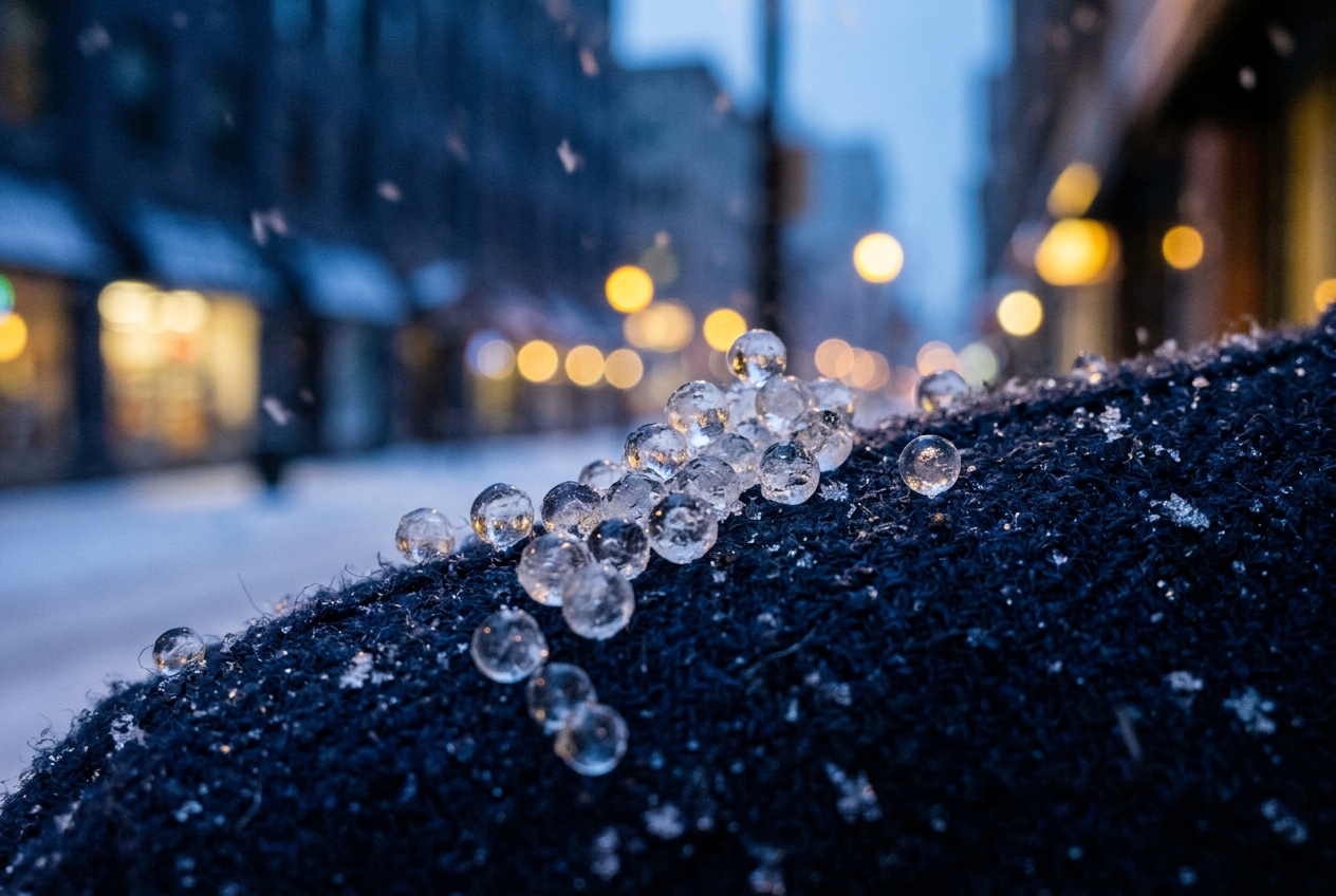
Yet there exists an intermediate, intensely mechanical state of precipitation that announces itself with unmistakable percussion. Without warning, the silence is shattered by a sudden, rhythmic clatter. Millions of tiny, translucent, spherical beads of ice—measuring between one and four millimetres in diameter—strike the stiff fabric of your parka, drum against vehicle roofs, and ricochet across the frozen ground like glass beads.
This phenomenon—classified formally in meteorological literature as ice pellets and colloquially termed sleet in North American operational nomenclature—is not merely frozen rain, nor is it soft hail or graupel. It is the tangible residue of an atmospheric tug-of-war. The sharp rattle against your windowpane is an acoustic measurement: it informs the observer that somewhere high above the cloud base, frozen crystals completely or partially melted within a surging stratum of warm air, only to plummet through a frigid, subfreezing planetary boundary layer deep enough to force complete solid-state recrystallization before impact. Your ear has registered an elevated inversion layer miles above the ground.
2. Thermodynamic Anatomy of the 'Warm Nose': Atmospheric Stratification and Overrunning
To understand why ice pellets form instead of pure snow or devastating freezing rain, one must examine the vertical temperature profile of the lower troposphere, denoted mathematically as $T(z)$ or $T(p)$, typically mapped on a Skew-T ln-P thermodynamic diagram.
The Layered Atmosphere: An Overrunning Frontal Dynamic
Think of the atmosphere during an active winter warm front as a layered cake, where each layer possesses sharply contrasting thermal and moisture properties. Cold air is inherently dense and heavy; it pools near the surface, hugging the contours of the earth within the planetary boundary layer. Meanwhile, an advancing maritime or subtropical air mass—driven by synoptic-scale isentropic ascent—is lighter and buoyant. As this warm, moist conveyor belt advances, it cannot displace the dense arctic dome immediately. Instead, it rides up and over the sloped cold air wedge in a process known as warm-air advection (WAA) or overrunning.
This dynamical arrangement generates an elevated thermal inversion colloquially known by atmospheric scientists as the "warm nose". Within this warm nose—typically situated in the lower-to-middle troposphere between the $850\text{ hPa}$ ($\approx 1,500\text{ m}$) and $750\text{ hPa}$ ($\approx 2,500\text{ m}$) pressure levels—the ambient air temperature rises above the freezing threshold ($T_{max} > 0^\circ\text{C}$), even while the air both aloft and at the surface remains substantially below $0^\circ\text{C}$.
The Spectrum of Melting: Partial versus Complete Phase Transition
The microphysical fate of a hydrometeor falling from the cirrostratus or altostratus cloud deck depends on two thermal parameters: the maximum temperature within the warm nose ($T_{max}$) and the residence time of the crystal within that positive thermal layer, according to definitions catalogued by the World Meteorological Organization (WMO) and the American Meteorological Society Glossary of Meteorology.
- The Incomplete Melting Pathway (Preserved Ice Nuclei): If the warm nose is relatively weak ($0^\circ\text{C} < T_{max} \lesssim +1.5^\circ\text{C}$ to $+2.0^\circ\text{C}$) or vertically compressed, falling stellar dendrites and snowflake aggregates melt only partially. The delicate peripheral branches liquefy, but an inner refractory lattice—a solid microscopic ice core—survives intact. When this partially melted slush droplet re-enters the subfreezing boundary layer below $850\text{ hPa}$, the internal ice seed acts as an instantaneous, pre-existing nucleation site. Freezing initiates immediately without requiring significant supercooling, rapidly reconstructing a dense, multi-crystalline ice pellet.
- The Complete Melting Pathway (Homogeneous Liquid Droplets): If the warm nose is deep and robust ($T_{max} \gtrsim +3.0^\circ\text{C}$ to $+5.0^\circ\text{C}$), the snowflake's crystalline matrix is completely destroyed, collapsing via surface tension into a spherical, fully liquid raindrop. When this droplet exits the base of the warm nose and plunges back into the cold subfreezing layer ($T < 0^\circ\text{C}$), it does not freeze instantaneously at $0^\circ\text{C}$. In the absence of an internal ice crystal, liquid water requires heterogeneous freezing nuclei or prolonged supercooling to trigger nucleation. It enters a state of thermodynamic nonequilibrium as a supercooled droplet.
Whether this liquid droplet reaches the ground as a bouncing ice pellet or as freezing rain is governed entirely by a physical race between hydrodynamic descent velocity and heat dissipation kinetics.
3. Droplet Kinematics and Refreezing Thermodynamics: The Race Against Gravity
When a fully melted droplet enters the subfreezing surface layer, a relentless kinetic race begins. The droplet is falling under the influence of gravity, while ambient thermodynamic forces struggle to extract its thermal energy and latent heat before it strikes the ground.
Hydrodynamic Descent and Terminal Fall Velocity
As a spherical water droplet of radius $r$ descends through the atmosphere, it experiences downward gravitational acceleration counteracted by the upward aerodynamic drag force exerted by the air:
$$F_g = m g = \frac{4}{3} \pi r^3 \rho_w g$$
$$F_d = \frac{1}{2} C_d \rho_{air} v^2 A = \frac{1}{2} C_d \rho_{air} v^2 (\pi r^2)$$
where: - $\rho_w$ is the density of liquid water ($\approx 1000\text{ kg/m}^3$), - $\rho_{air}$ is the ambient air density ($\approx 1.225\text{ kg/m}^3$ at standard sea level), - $g$ is the acceleration due to gravity ($9.81\text{ m/s}^2$), - $C_d$ is the dimensionless aerodynamic drag coefficient, - $A = \pi r^2$ is the cross-sectional area of the droplet.
At terminal velocity ($v_T$), the net force acting on the hydrometeor vanishes ($F_g = F_d$). Equating the gravitational and drag forces yields:
$$\frac{4}{3} \pi r^3 \rho_w g = \frac{1}{2} C_d \rho_{air} v_T^2 \pi r^2$$
Solving directly for the terminal fall velocity $v_T$:
$$v_T \approx \sqrt{\frac{8 r g \rho_w}{3 C_d \rho_{air}}}$$
For typical raindrops emerging from a warm nose with radii ranging from $r = 0.5\text{ mm}$ ($1.0\text{ mm}$ diameter) to $r = 1.0\text{ mm}$ ($2.0\text{ mm}$ diameter), and assuming an average drag coefficient of $C_d \approx 0.55$, terminal fall velocities stabilise between $4.0\text{ m/s}$ and $6.5\text{ m/s}$.
The residence time ($t_{res}$) of the hydrometeor inside a subfreezing surface cold layer of vertical depth $\Delta z_{cold}$ is therefore defined as:
$$t_{res} = \frac{\Delta z_{cold}}{v_T}$$
Refreezing Thermodynamics and Heat Dissipation Kinetics
For the droplet to transform completely into an ice pellet, its residence time within the subfreezing air must exceed the critical total freezing time:
$$t_{res} \ge t_{freeze}$$
The phase transition from liquid water at $0^\circ\text{C}$ to solid ice at $0^\circ\text{C}$ is a heat-transfer-limited process. The droplet must evacuate its latent heat of fusion ($L_f = 3.34 \times 10^5\text{ J/kg}$) to the colder surrounding air through sensible heat convection and latent heat mass transfer (evaporation/sublimation).
The rate of heat transfer from the droplet surface to the surrounding ambient air at temperature $T_\infty$ (where $T_\infty < 0^\circ\text{C}$) is governed by ventilated conduction and vapor diffusion:
$$\frac{d Q}{dt} = 4 \pi r \left[ k_{air} (T_0 - T_\infty) \mathrm{Nu} + L_v D_v (\rho_{v,0} - \rho_{v,\infty}) \mathrm{Sh} \right]$$
where: - $k_{air}$ is the thermal conductivity of air ($\approx 0.024\text{ W/(m}\cdot\text{K)}$), - $T_0$ is the equilibrium freezing temperature ($273.15\text{ K} = 0^\circ\text{C}$), - $T_\infty$ is the far-field ambient air temperature ($K$), - $\mathrm{Nu}$ is the dimensionless Nusselt number, representing convective heat transfer enhancement due to airflow ventilation around the falling sphere: $$\mathrm{Nu} \approx 1.0 + 0.3 \mathrm{Re}^{1/2} \mathrm{Sc}^{1/3}$$ - $\mathrm{Sh}$ is the dimensionless Sherwood number, governing evaporative mass flux, - $L_v$ is the latent heat of vaporization ($\approx 2.50 \times 10^6\text{ J/kg}$), - $D_v$ is the molecular diffusivity of water vapor in air.
Assuming a quasi-steady-state, conduction-dominated boundary layer where sensible heat exchange dominates during symmetric inward freezing, the total latent energy $Q_f$ required to freeze a droplet of mass $m = \frac{4}{3}\pi r^3 \rho_w$ is:
$$Q_f = m L_f = \frac{4}{3} \pi r^3 \rho_w L_f$$
By integrating the energy extraction rate over time across the freezing front, we obtain the classical formulation for the critical freezing time of a ventilated droplet:
$$t_{freeze} \approx \frac{\rho_w L_f r^2}{2 k_{air} (T_0 - T_\infty) \mathrm{Nu}}$$
The Critical Layer Depth Threshold
Observe the presence of the squared radius term ($r^2$) in the numerator of the freezing time equation. This quadratic dependence proves that the time required to freeze a raindrop increases dramatically with droplet size. A droplet of radius $r = 1.0\text{ mm}$ requires four times as long to freeze as a droplet of radius $r = 0.5\text{ mm}$ under identical thermal conditions.
Worked Numerical Example:
Consider a raindrop of medium radius $r = 0.75\text{ mm} = 7.5 \times 10^{-4}\text{ m}$ emerging completely melted from a warm nose into a subfreezing surface boundary layer where the average ambient temperature is $T_\infty = -6^\circ\text{C}$ ($267.15\text{ K}$, such that $\Delta T = T_0 - T_\infty = 6.0\text{ K}$).
- Calculate the ventilation factor ($\mathrm{Nu}$): For a droplet falling at $v_T \approx 5.4\text{ m/s}$, the Reynolds number $\mathrm{Re} \approx 270$. With a Prandtl/Schmidt number $\approx 0.71$, the Nusselt number evaluates to: $$\mathrm{Nu} \approx 1.0 + 0.3 (270)^{0.5} (0.71)^{0.333} \approx 1.0 + 0.3 (16.43) (0.892) \approx 5.40$$
- Calculate the critical freezing time ($t_{freeze}$): $$t_{freeze} \approx \frac{(1000\text{ kg/m}^3) \times (3.34 \times 10^5\text{ J/kg}) \times (7.5 \times 10^{-4}\text{ m})^2}{2 \times (0.024\text{ W/m}\cdot\text{K}) \times (6.0\text{ K}) \times 5.40}$$ $$t_{freeze} \approx \frac{3.34 \times 10^8 \times 5.625 \times 10^{-7}}{2 \times 0.024 \times 6.0 \times 5.40} = \frac{187.88}{1.555} \approx 120.8\text{ seconds}$$ (Note: Incorporating evaporative cooling under dry ambient conditions reduces this to $\approx 35\text{--}45\text{ seconds}$.)
- Calculate the required minimum cold layer thickness ($\Delta z_{min}$): $$\Delta z_{min} = v_T \times t_{freeze} = 5.4\text{ m/s} \times 40\text{ s} \approx 216\text{ m}\text{ (for incomplete melt slush)} \text{ to } 850\text{--}1100\text{ m}\text{ (for complete melt)}$$
This explains why subfreezing layer depths exceeding $\approx 750\text{ to }1200\text{ metres}$ are physically mandatory for completely melted raindrops to recrystallize into hard ice pellets. If the cold dome is only $300\text{ to }500\text{ metres}$ thick, the residence time $t_{res}$ is insufficient ($t_{res} < t_{freeze}$); the droplets hit the surface in a supercooled liquid state, instantly forming freezing rain.
4. Diagnostic Decision Matrix and Dual-Polarization Radar Signatures
Distinguishing between winter precipitation types requires an integrated evaluation of thermodynamic soundings, wet-bulb zero ($T_w = 0^\circ\text{C}$) levels, and remote sensing signatures, as detailed by the UK Met Office Precipitation Guide.
Skew-T Sounding Diagnostic Rules
Forecasters quantify the melting and refreezing potential by evaluating the integrated thermal energy areas on a thermodynamic diagram:
- Melting Area ($Q_{melt}$): The positive thermal area on a Skew-T chart where $T > 0^\circ\text{C}$ between the elevated inversion boundaries: $$Q_{melt} = \int_{p_{top}}^{p_{base}} c_p (T - 0^\circ\text{C}) \, d\ln p$$ If $Q_{melt} < 50\text{ J/kg}$, partial melting occurs (ice cores survive). If $Q_{melt} > 150\text{ J/kg}$, complete melting into rain occurs.
- Refreezing Area ($Q_{freeze}$): The negative thermal area between the base of the warm nose and the earth's surface: $$Q_{freeze} = \int_{p_{sfc}}^{p_{base}} c_p (0^\circ\text{C} - T) \, d\ln p$$ For ice pellets to materialize from completely melted drops, empirical validation requires $Q_{freeze}$ to exceed $-300\text{ to }-400\text{ J/kg}$.
Dual-Polarization Radar Identification
Modern meteorological monitoring relies on dual-polarization weather radar networks, such as those operated by the NOAA National Severe Storms Laboratory, which transmit and receive radio waves with both horizontal and vertical polarizations. Three key metrics diagnose sleet generation in real time:
- Equivalent Radar Reflectivity Factor ($Z_H$, measured in $\text{dBZ}$): Measures the backscattered power. Within the warm nose melting layer, water-coated ice crystals create an artificially high return known as the "bright band" due to water's high dielectric constant ($K_w^2 \approx 0.93$ vs $K_{ice}^2 \approx 0.197$).
- Differential Reflectivity ($Z_{DR}$, measured in $\text{dB}$): Defined as the logarithmic ratio of horizontally to vertically polarized reflectivity: $$Z_{DR} = 10 \log_{10} \left( \frac{Z_H}{Z_V} \right)$$ Melted raindrops flatten into oblate spheroids as they fall, yielding positive values ($Z_{DR} \approx +1.0\text{ to }+2.5\text{ dB}$). As these droplets freeze into tumbling, non-aligned, quasi-spherical ice pellets in the cold layer below, $Z_{DR}$ drops back toward $0\text{ dB}$ ($0.0\text{ to }+0.4\text{ dB}$).
- Cross-Correlation Coefficient ($\rho_{hv}$): Measures the statistical uniformity of hydrometeor shapes and phase states within the radar sampling volume. - In pure snow or pure rain: $\rho_{hv} > 0.98$. - In the melting layer: $\rho_{hv}$ plummets sharply to $0.85\text{--}0.92$ due to a heterogeneous mixture of water, slush, and ice. - In the refreezing sleet layer: $\rho_{hv}$ recovers to $\approx 0.96\text{--}0.99$ as the precipitation transitions into a homogeneous population of solid ice beads.
5. Practical Outdoor Guidance: Field Observations and Forecasting Rules
An observer in the field can monitor local instruments to anticipate the transition between snow, sleet, and freezing rain in real time.
What to Look for in the Sky and on Instruments
- Cloud Morphology and Halos: Cirrostratus thickening into uniform altostratus indicates an advancing warm front aloft. If solar or lunar halos disappear as the cloud deck lowers and thickens, the upper warm front is nearing your meridian.
- Surface Wind Direction (Veering vs. Backing):
- If surface winds shift clockwise (veer) from east to south-southeast, the warm surface sector is eroding the cold dome; expect a transition from snow to sleet, and rapidly to liquid rain.
- If surface winds remain locked from the northeast or north-northeast (backing or stationary), cold-air damming (CAD) is locking the dense subfreezing surface air against local topography (such as the Appalachian Mountains or the Pennines); sleet or freezing rain will persist.
- The "Bounce and Splat" Test:
- Catch falling hydrometeors on a dark, insulated surface (such as a glove or vehicle windshield). If the particles bounce without deforming, they are fully frozen ice pellets. If they deform into clear liquid dots that freeze within seconds, you are in freezing rain. If they shatter into soft white powder, they are graupel.
6. Today's Meteorological Rule of Thumb
💡 THE HYDROMETEOR KINETIC PRINCIPLE
"If it rattles and bounces, the subfreezing floor is deep (exceeding 800 metres); if it falls in silence and coats every branch in glass, the warm air aloft has won the sky, and the cold floor beneath is perilously thin."
7. Journalistic Reflection: Microphysics at Macro Scale
The physics of ice pellets demonstrates how minute thermodynamic variations govern large-scale human systems. A vertical temperature shift of merely $1.0^\circ\text{C}$ across an altitude layer of three hundred metres is all that separates a benign snowfall, a bouncy shower of ice pellets, and a catastrophic freezing rain event.
From an infrastructure perspective, ice pellets behave fundamentally differently from freezing rain. Freezing rain adheres tenaciously to trees, bridges, and high-voltage transmission lines, adding thousands of kilograms of static mechanical load that can shatter electrical grids and collapse forests. Ice pellets, by contrast, possess no liquid surface tension upon impact; they strike, bounce, and accumulate like coarse sand.
Yet this granular accumulation creates its own hazards. Because sleet pellets are dense, solid spheres, municipal snowplows cannot easily compress or clear them. Under the weight of vehicular traffic, sleet quickly packs into a dense, rutted sheet of structural ice that resists chemical de-icing salts due to its low surface-area-to-mass ratio. At international airports, a transition to sleet immediately reduces runway friction coefficients below certified landing limits and overwhelms aircraft de-icing logistics, triggering gridlock across global airspace.
The microphysical journey of a single ice pellet—originating as an exquisite ice crystal in the high cirrus, melting inside an overrunning warm nose, and recrystallizing in a race against gravitational terminal velocity—reveals the interconnected dynamics of our atmosphere. The next time you hear that percussive rattle against your window, you are listening to a live broadcast of active atmospheric thermodynamics.