Shelf Cloud Dynamics & Arcus Wedge Kinematics: How Cold Density Current Undercutting and Forced Updraft Condensation Sculpt Tiered Storm Collars
1. Opening Scene: The Gathering Horizon
The afternoon air across the open grassland hangs with suffocating, motionless density. At 15:30 local time, the ambient temperature registers an oppressive 33°C (91.4°F), and the air feels saturated, thick with humidity that clings to the skin. The wind has fallen entirely dead. In this eerie, pre-convective calm, the atmosphere feels suspended under an invisible weight. The only sound is the rhythmic, dry cadence of cicadas vibrating in the parched roadside brush.
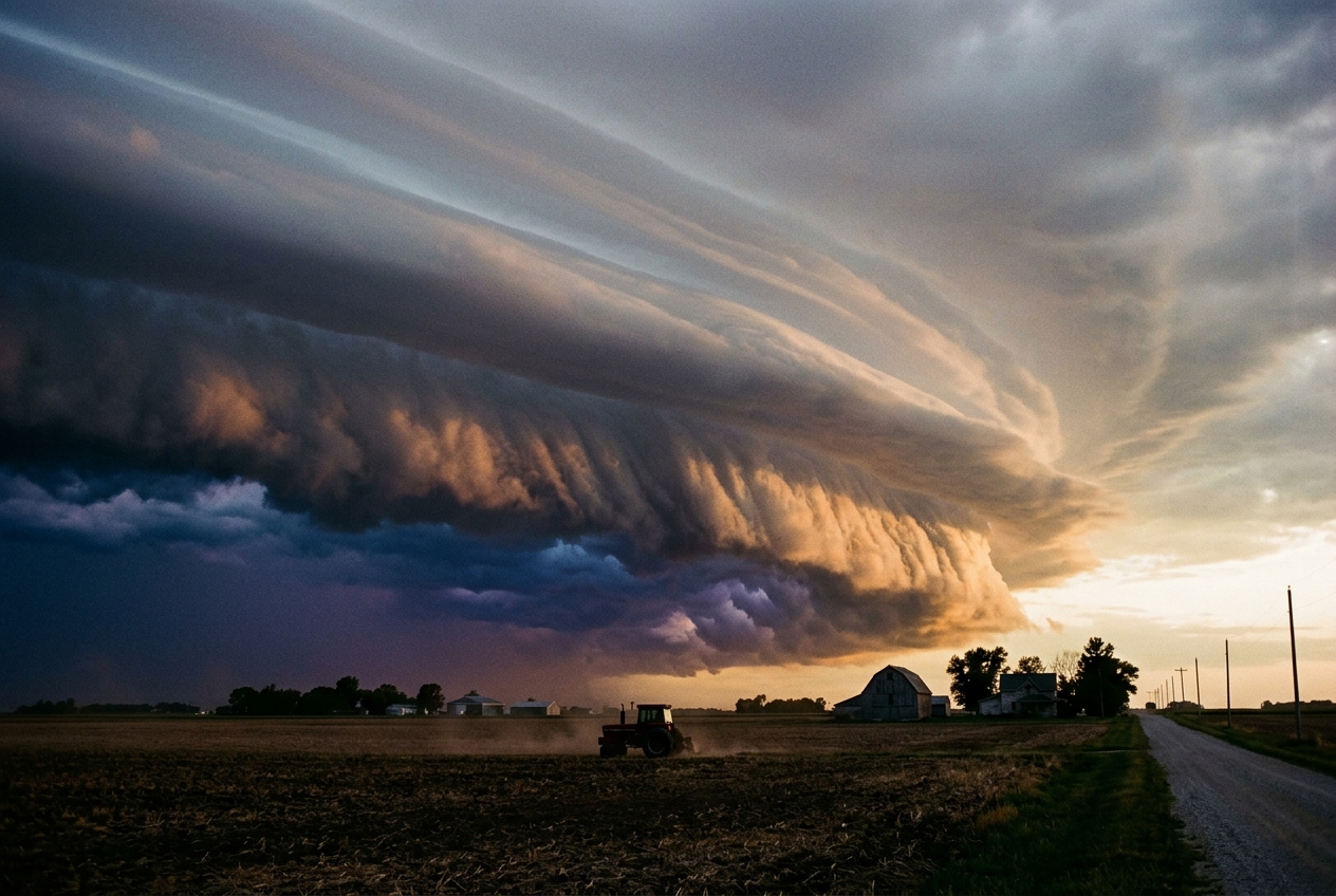
Then, along the western horizon, the sky curdles. What began an hour ago as distant, towering cauliflowers of cumulus congestus has consolidated into a singular, bruised, slate-blue monolith that spans fifty miles of the horizon. As the upper anvil of the cumulonimbus creeps overhead, it blotted out the sun, plunging the landscape into a premature, bronze-tinted twilight.
Two miles ahead of the rain sheet, a horizontal architecture begins to sculpt itself out of the low cloud base. It is not merely a dark cloud; it is a sculpted, terraced flying buttress—an arcus wedge—jutting outward from the storm’s lower skirt like the chiseled prow of an ocean liner. Its underside is ragged, boiling with chaotic, shredded gray fragments of scud that writhe and roll as if ground beneath an unseen millstone. Above this violent underbelly, the cloud rises in smooth, striated, porcelain-like terraces that sweep upward and backward into the belly of the parent storm.
Suddenly, before a single drop of rain has fallen, the physical world shifts. The air pressure against your inner ear flexes inward with a distinct, popping sensation. A sudden, sharp scent fills the nostrils—not merely the fresh, earthy geosmin of petrichor, but a clean, metallic tang of ozone forged by lightning channels miles away.
The leaves of the willow and poplar trees suddenly invert, exposing their pale, silver underbellies to the sky as a faint, cool draft whispers across the dry soil. Within thirty seconds, this gentle whisper sharpens into a deafening roar. The temperature plunges twelve degrees Celsius in under two minutes. The wind shifts one hundred and eighty degrees, hammering forward in violent, straight-line horizontal blasts that kick up a wall of choking dust. You are standing at the leading edge of an atmospheric gravity current: the gust front has arrived.
2. What Is Actually Happening: The Mechanics in Plain English
To understand the architecture of the shelf cloud, we must abandon the notion that air is empty space. At the scale of the planetary boundary layer, the atmosphere behaves like a vast, compressible fluid governed by the laws of thermodynamics and hydrodynamics.
The Atmospheric Layer Cake and the Sinking Sledgehammer
Think of the atmosphere on a hot summer afternoon as a delicate, multi-tiered cake. The lowest tier, resting against the baked earth, consists of warm, buoyant, water-vapor-saturated air. Because warm air is less dense than the cooler air sitting high in the troposphere, it is inherently unstable; it wants to rise, much like an inflated ball held under water.
Inside the core of the thunderstorm, high-altitude air encounters heavy falling rain and hail. As precipitation falls through dry air beneath the storm base, water droplets rapidly evaporate. Evaporation is an endothermic phase change—it extracts tremendous latent heat from the surrounding air. The air chills dramatically, becoming far colder and heavier than the environmental air surrounding it.
This refrigerated, dense pocket of air cannot remain suspended. It collapses toward the ground as a violent, rain-cooled downdraft. When this plummeting column of dense fluid strikes the flat surface of the Earth, it cannot penetrate the soil; instead, it behaves precisely like a bucket of ice water hurled onto a linoleum kitchen floor. It splashes downward and surges outward in all directions, creating an advancing pool of cold, dense air known to meteorologists as a cold pool.
The Bulldozer Wedge and the Lifting Condensation Level
Because the cold downdraft air is significantly denser than the warm ambient air sitting ahead of the storm, it hugs the ground, acting as a massive aerodynamic wedge—an atmospheric bulldozer. As this cold pool charges forward across the terrain, its blunt, elevated front (the "nose" of the density current) scoops up the stagnant, warm, humid boundary-layer air and forces it violently upward.
As this warm surface air is forced to ascend along the sloping roof of the cold wedge, it encounters lower atmospheric pressure aloft. The rising air expands, and under the laws of adiabatic thermodynamics, expansion causes the air parcel to cool.
Once the ascending warm air cools to its dew point, it reaches its Lifting Condensation Level (LCL). At this precise altitude, invisible water vapor abruptly condenses into billions of microscopic liquid cloud droplets.
Because the air is being lifted uniformly along a continuous, linear boundary spanning dozens of kilometers, a crisp, horizontal cloud formation materializes right at the boundary between the cold outflow beneath and the warm inflow above. This is the shelf cloud—formally classified by the World Meteorological Organization (WMO) International Cloud Atlas as the supplementary cloud feature arcus.
Why Is the Shelf Cloud Terraced and Striated?
A close observer will notice that a mature shelf cloud rarely looks like a single smooth blanket; it displays sculpted, horizontal tiers or terraces that resemble a monumental set of stadium bleachers.
This terracing is the visual fingerprint of dynamic fluid shear and pulsating outflow: 1. Fluid Shear (Kelvin-Helmholtz Waves): The warm inflow is rushing toward the storm above, while the cold outflow is rushing away from the storm below. Where these two opposing streams rub against one another, friction and density differences generate curling, rolling wave instabilities. 2. Pulsating Downdraft Surges: Convective storms do not breathe out a steady stream; they pulse in discrete surges. Each microburst or precipitation core injects a fresh wave of cold air into the cold pool, pushing the wedge forward in distinct steps and carving tiered laminations into the condensing cloud deck.
3. The Science: Fluid Dynamics and Density Current Kinematics
For atmospheric scientists and advanced field observers, the propagation of a gust front is modeled not as a vague weather boundary, but as a classic hydrodynamic gravity current (or density current). The motion is driven by the horizontal pressure gradient created by the density difference between the cold outflow pool and the warm environmental air.
The Benjamin-von Kármán Density Current Velocity Formula
In fundamental fluid mechanics, the propagation speed of a semi-infinite gravity current head advancing through a less dense ambient fluid over a flat, non-rotating boundary is determined by balancing the horizontal hydrostatic pressure gradient force against the inertial resistance of the ambient fluid.
Applying the classical Benjamin-von Kármán formulation modified for atmospheric thermodynamics with virtual potential temperature ($\theta_v$), the forward propagation velocity $v$ of the gust front nose is given by:
$$v = k \sqrt{g \left( \frac{\Delta \theta_v}{\theta_{v,\text{ambient}}} \right) H}$$
Where: * $v$ = Horizontal propagation velocity of the advancing gust front ($\text{m/s}$). * $k$ = Internal Froude number (a dimensionless internal shape factor, typically observed between $k \approx 0.75$ and $k \approx 1.10$ in the atmospheric boundary layer; standard theoretical value for a frictionless wedge is $k = \sqrt{2} \approx 1.414$, but surface drag reduces it in field environments to roughly $0.80 - 0.90$). * $g$ = Acceleration due to gravity ($9.81\text{ m/s}^2$). * $\theta_{v,\text{ambient}}$ = Virtual potential temperature of the warm environmental inflow air ($\text{K}$). Virtual potential temperature accounts for both temperature and the buoyancy effect of moisture. * $\Delta \theta_v$ = Virtual potential temperature deficit between the warm inflow and the cold outflow pool ($\theta_{v,\text{ambient}} - \theta_{v,\text{pool}}$ in $\text{K}$). * $H$ = Total vertical depth (height) of the advancing cold pool head ($\text{m}$).
Worked Example: Calculating Gust Front Velocity
Consider an intense summer severe thunderstorm bearing down on a plains observatory. A surface weather station and atmospheric profiler measure the following boundary-layer parameters: * Ambient warm air virtual potential temperature: $\theta_{v,\text{ambient}} = 305.15\text{ K}$ ($32.0^\circ\text{C}$ with high moisture). * Cold pool virtual potential temperature: $\theta_{v,\text{pool}} = 293.15\text{ K}$ ($20.0^\circ\text{C}$ rain-cooled air). * Virtual potential temperature deficit: $\Delta \theta_v = 305.15 - 293.15 = 12.0\text{ K}$. * Doppler SODAR/radar measured cold pool head depth: $H = 1,800\text{ m}$. * Empirical internal Froude factor for surface roughness: $k = 0.85$.
Let us calculate the theoretical propagation speed of the shelf cloud's leading edge:
Step 1: Compute the fractional buoyancy deficit: $$\frac{\Delta \theta_v}{\theta_{v,\text{ambient}}} = \frac{12.0}{305.15} \approx 0.039325$$
Step 2: Multiply by gravitational acceleration and cold pool depth: $$g \left( \frac{\Delta \theta_v}{\theta_{v,\text{ambient}}} \right) H = 9.81 \times 0.039325 \times 1800 \approx 694.40\text{ m}^2/\text{s}^2$$
Step 3: Extract the square root to determine the characteristic gravity wave speed: $$c = \sqrt{694.40} \approx 26.35\text{ m/s}$$
Step 4: Scale by the internal Froude factor $k$: $$v = 0.85 \times 26.35 \approx 22.40\text{ m/s}$$
Converting this velocity into standard terrestrial units: $$v = 22.40\text{ m/s} \times 3.6 = \mathbf{80.64\text{ km/h}} \quad (\approx \mathbf{50.1\text{ mph}} \text{ or } \mathbf{43.5\text{ knots}})$$
The Barometric Pressure Jump ($\Delta P$)
As the cold pool overtakes a stationary surface barometer, the instrument registers an abrupt, step-like increase in atmospheric pressure known as the "thunderstorm nose" or barometric jump.
This total pressure perturbation ($\Delta P_{\text{total}}$) consists of two distinct physical components: 1. The Hydrostatic Component ($\Delta P_{\text{hydro}}$): The added weight of the denser, cold air column replacing the lighter, warm air column above the barometer. 2. The Dynamic Stagnation Component ($\Delta P_{\text{dyn}}$): The kinetic energy of the rushing horizontal density current converting into static pressure as it decelerates against surface obstacles and stagnation points, governed by Bernoulli's theorem:
$$\Delta P_{\text{dyn}} = \frac{1}{2} \rho v_{\text{rel}}^2$$
Where: * $\rho$ = Mean air density of the boundary layer ($\approx 1.20\text{ kg/m}^3$). * $v_{\text{rel}}$ = Velocity of the advancing outflow relative to the stationary surface ($\text{m/s}$).
Worked Example: Calculating the Dynamic Pressure Surge
Using the gust front velocity calculated above ($v = 22.40\text{ m/s}$) and an ambient air density of $\rho = 1.18\text{ kg/m}^3$:
$$\Delta P_{\text{dyn}} = \frac{1}{2} \times 1.18 \times (22.40)^2 = 0.59 \times 501.76 = \mathbf{296.04\text{ Pa}} \approx \mathbf{2.96\text{ hPa (mbar)}}$$
When added to the hydrostatic accumulation of the 1,800-meter-deep cold pool ($\approx 1.5 - 2.5\text{ hPa}$), the observer's digital barometer will jump by 4.5 to 5.5 hectopascals (hPa) in under three minutes. This rapid spike is what causes human eardrums to pop as a shelf cloud passes overhead.
4. Practical Outdoor Guidance: Identifying and Surviving the Wedge
Advanced observers, mariners, aviators, and outdoor professionals must rapidly distinguish between different low-altitude cloud formations. Confusing an outflow-driven shelf cloud with an inflow-driven wall cloud or an undular roll cloud can lead to disastrous miscalculations of wind hazards and tornadic potential.
Visual Field Diagnostics: What to Look For
When an ominous, low-hanging cloud structure looms on the horizon, systematically evaluate these three diagnostic layers:
- The Upper Brow (Laminar Striations): Look at the leading, upper edge of the cloud. If you see crisp, smooth, terraced bands resembling smooth carved marble, this indicates high dynamic lift where laminar ambient air is being forced smoothly upward over a stable cold pool interface. The sharper and more stratified these bands are, the more powerful the vertical displacement rate.
- The Underbelly (Ragged Pannus / Scud): Examine the turbulent cloud fragments beneath the main shelf. In a shelf cloud, this scud (pannus) is tumbling chaotically forward and downward in the turbulent shear zone behind the gust front nose. In a rotating wall cloud, by contrast, scud is being sucked rapidly upward into the central vortex.
- The Precipitation Interface: A shelf cloud is backed immediately by a curtain of heavy rain or hail (often showing green or turquoise refraction due to dense water/ice scatter). If the lowering cloud is completely surrounded by bright, dry air with rain falling far to the northeast, you may be looking at a supercell updraft base rather than a shelf cloud.
For detailed identification flowcharts, consult the NOAA National Severe Storms Laboratory (NSSL) Thunderstorm Guide and the American Meteorological Society Glossary on Gust Fronts.
Instrument Monitoring and Warning Thresholds
If you are equipped with an outdoor weather station, barometric altimeter, or marine instrument cluster, monitor these three immediate parameters:
- Microbarograph / Barometer: Watch for the pre-frontal pressure dip (a subtle drop of 0.5–1.0 hPa caused by warm inflow evacuation) followed instantly by a knife-like, vertical pressure rise ($\ge 3.0\text{ hPa}$ within 5 minutes). This is the unmistakable hydrostatic and dynamic fingerprint of the gust front nose.
- Anemometer and Wind Vane: A sudden backing or veering of the wind direction by $90^\circ\text{ to }180^\circ$, accompanied by a total collapse of wind speed for 30 seconds, followed by violent, turbulent gusts.
- Rapid-Response Thermometer: A temperature drop rate exceeding $\ge 1.0^\circ\text{C}$ per 30 seconds.
Lead-Time Calculation Heuristic for Field Personnel
If you observe a shelf cloud approaching in open terrain, use this straightforward mathematical heuristic to determine your remaining evacuation lead time ($t_{\text{lead}}$):
$$t_{\text{lead}} \approx \frac{D_{\text{est}}}{v_{\text{est}}}$$
Where: * $D_{\text{est}}$ = Estimated distance to the cloud base (km). (Use angular height: when a shelf cloud spans $45^\circ$ above the horizon, its leading edge is approximately at a distance equal to its base altitude, typically $1.0\text{ to }1.5\text{ km}$). * $v_{\text{est}}$ = Estimated propagation speed (assume a baseline severe density current velocity of $1.0\text{ km/min} \approx 60\text{ km/h}$).
To expand your cloud identification skills across non-severe regimes, reference the Met Office Cloud Spotting Guide.
5. Today's Meteorological Rule of Thumb
"If the dark cloud shelf is stacked in smooth, outward-descending terraces with cold wind rushing out of its base, you are facing straight-line outflow, not a tornado: the wind will hit before the rain, and it will strike with the full kinetic weight of a collapsing sky."
Whenever you witness an arcus wedge rolling across the plains, remember that you are not observing a static painting on the sky, but the visible surface of a colossal, high-speed fluid engine—a gravity current where the refrigerated heights of the troposphere sweep down to claim the earth below.