Rossby Wave Breaking & Potential Vorticity Streamers: How Irreversible Wave Overturning and Stratospheric Intrusions Steer Extreme Weather Deluges
1. Opening Scene: The Breath Before the Deluge
Stand upon an open hillside in early autumn—perhaps overlooking the wind-ruffled waters of the Ligurian Sea or along the rolling escarpments of the southern English Downs—and attend closely to the atmosphere’s subtle physical choreography.
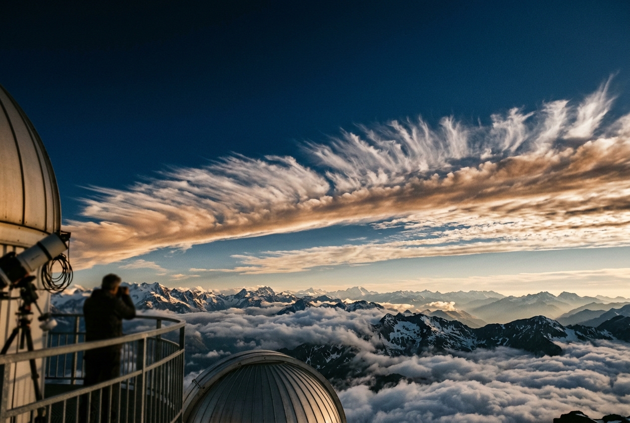
The morning begins with a peculiar, electric stillness. The air at ground level feels deceptively mild, almost uncomfortably humid, carrying the damp, sweet scent of warm earth, crushed pine, and distant maritime brine. Yet, looking upward toward the zenith, the sky tells an entirely different story. High above, the pale blue vault is being scored by razor-thin, ice-white filaments of cirrus uncinus—the classic “mare’s tails”—racing from the south-southwest at breathtaking speed. These cirrus bands do not drift lazily; they stretch, twist, and sheer out into violent, fibrous plumes across the upper troposphere, betraying the presence of a ferocious jet stream screaming at over two hundred kilometres per hour twelve kilometres above your head.
Within an hour, the physical sensations intensify. The mercury in your pocket barometer begins an unmistakable, steepening downward slide, dropping two, three, four hectopascals in rapid succession. Your skin senses a sudden drop in ambient air density, accompanied by a sharp change in the wind: the gentle onshore breeze veers abruptly to the south-southeast, picking up gusts that rattle the canopy with a dry, hissing urgency. To the southwest, the horizon vanishes. A colossal, dark baroclinic wall of cloud advances, not as a gentle curtain of grey, but as a sharply delineated, bruised purple shelf.
                       UPPER-LEVEL JET STREAM (250 hPa)
        ===================> STRATOSPHERIC AIR INTRUSION ===================>
                    \
                     \  Dry Stratospheric Air (High PV) Descends
                      \
                       v
         ~ ~ ~ ~ ~ ~ ~ ~ ~ ~ ~ ~ ~ ~ ~ ~ ~ ~ ~ ~ ~ ~ ~ ~ ~ ~ ~ ~ ~ ~ ~ ~ ~ ~
         WARM CONVEYOR BELT (ASCENT)   |   DRY INTRUSION SLOT (SUBSIDENCE)
         Bright Cirrus / Deep Cumulus  |   Cloudless, Razor-Sharp Blue/Black
         Heavy Rain & Flash Deluge     |   Ozone Scent & Plunging Dewpoint
         -------------------------------------------------------------------
                        SURFACE CYCLONE & PRESSURE FALLS
As the leading edge passes overhead, the temperature drops several degrees in seconds. The air smells briefly of lightning ozone and sharp cold, followed instantly by the heavy, metallic odour of geosmin as the first massive raindrops strike the baking soil. You are not merely watching a rainstorm arrive; you are standing in the direct crosshairs of a planetary-scale wave that has crested, steepened, and broken in the stratosphere, plunging a razor-sharp blade of dry, rotating stratospheric air straight into the unstable maritime troposphere below.
2. What's Actually Happening — Plain English First
To understand why a clear autumn morning can erupt into an explosive cyclone, we must zoom out ten thousand kilometres into space and view Earth's atmosphere as a vast, continuous fluid machine.
The Atmosphere as a Tiered Fluid
Think of the atmosphere as a tiered, multi-layered cake rotating on a giant turntable. The lower layer—the troposphere—is warm, moist, thick, and dense near the equator, but shallow, frigid, and dry over the poles. Separating the troposphere from the stratosphere above is an invisible aerodynamic boundary called the tropopause. In the subtropics, this boundary sits high in the sky, roughly sixteen kilometres up. Over the Arctic, it dips down to barely eight kilometres.
Along the boundary where polar cold collides with subtropical heat, the atmosphere establishes a colossal thermal contrast. This temperature gradient creates a permanent, high-altitude river of wind: the polar-front jet stream. Guided by Earth's rotation, this jet does not blow in a straight line; it meanders in massive, planet-girdling waves known as Rossby waves, discovered by the pioneering meteorologist Carl-Gustaf Rossby.
When Giant Atmospheric Waves Break
We are all familiar with how water waves break upon an ocean beach. In deep water, a swell glides smoothly forward without losing its shape. But as it enters shallow water, the bottom of the wave slows down while its crest surges ahead. The wave steepens, becomes top-heavy, curls forward into a tubular lip, and crashes irreversibly into foam and spray, mixing sea and air together.
Rossby waves do exactly the same thing, but horizontally across continents and oceans:
- Linear Meandering: Initially, the jet stream meanders gently north and south in smooth, symmetrical sine waves.
- Non-Linear Steepening: As the amplitude of the wave grows, horizontal wind shears grab the crests and troughs. The wave stretches, distorts, and begins to tilt.
- Irreversible Overturning (Rossby Wave Breaking): The wave curls so violently that high-altitude polar air is flung equatorward, while tropical air is shoved poleward. The wave "breaks" sideways across the weather map.
When an atmospheric wave breaks, it draws down an elongated, razor-thin tongue of pure stratospheric air deep into the mid-latitudes. Meteorologists call this structure a potential vorticity streamer (or PV streamer).
Because stratospheric air is exceptionally dry, stable, and spinning rapidly with Earth's planetary rotation, dropping this heavy, spinning filament into the warm, moisture-laden lower troposphere acts like plunging a spinning immersion blender into a vat of warm water. The stratospheric streamer creates a powerful vacuum effect: it vigorously sucks warm, moist surface air upward ahead of its path, spinning it into a furious vortex, while carving a bone-dry, cloud-free slot immediately behind it.
3. The Science: Potential Vorticity and Dynamic Wave Breaking
For atmospheric dynamicists and synoptic forecasters, potential vorticity is the foundational currency of large-scale meteorology. It unifies thermodynamics and fluid rotation into a single conserved tracer.
The Dynamic Tropopause and the Ertel Potential Vorticity
In 1942, the German meteorologist Hans Ertel formulated the complete, three-dimensional invariant for an inviscid, adiabatic fluid: Ertel Potential Vorticity.
Mathematically, Ertel Potential Vorticity $q$ is defined as:
$$q = \frac{1}{\rho} \vec{\omega}_a \cdot \nabla \theta$$
Where: * $\rho$ is the atmospheric density ($\text{kg}\cdot\text{m}^{-3}$). * $\vec{\omega}_a = (\vec{\nabla} \times \vec{u} + 2\vec{\Omega})$ is the three-dimensional absolute vorticity vector, comprising relative vorticity and planetary spin ($2\vec{\Omega}$). * $\nabla \theta$ is the three-dimensional gradient of potential temperature ($\theta = T (p_0/p)^{R/c_p}$).
Under the hydrostatic approximation in isentropic coordinates (where potential temperature $\theta$ serves as the vertical coordinate), Ertel PV simplifies elegantly to:
$$P = -g \left( \zeta_\theta + f \right) \frac{\partial \theta}{\partial p}$$
Where: * $g$ is the gravitational acceleration ($9.81\text{ m}\cdot\text{s}^{-2}$). * $\zeta_\theta = \left( \frac{\partial v}{\partial x} - \frac{\partial u}{\partial y} \right)_\theta$ is the relative vorticity evaluated on a constant isentropic ($\theta$) surface. * $f = 2\Omega \sin\phi$ is the Coriolis parameter at latitude $\phi$. * $-\frac{\partial \theta}{\partial p}$ is the static stability parameter.
Potential vorticity is measured in Potential Vorticity Units (PVU), where:
$$1\text{ PVU} = 1.0 \times 10^{-6}\text{ m}^2\text{ s}^{-1}\text{ K}\cdot\text{kg}^{-1}$$
In the troposphere, where air is well-mixed and vertical stability is modest, typical values of $P$ hover between $0.2$ and $0.8\text{ PVU}$. In the stratosphere, strong ozone heating creates steep vertical potential temperature gradients ($-\partial\theta/\partial p \gg 0$), causing $P$ to jump abruptly to values exceeding $4.0\text{ to }10.0\text{ PVU}$.
Atmospheric scientists at the European Centre for Medium-Range Weather Forecasts (ECMWF) and NOAA Physical Sciences Laboratory define the dynamic tropopause as the continuous, undulating isosurface of $2.0\text{ PVU}$ (or $1.5\text{ PVU}$ in subtropical studies).
=============================================================================
                      DYNAMIC TROPOPAUSE (2.0 PVU)
 STRATOSPHERE  (High PV: P > 4.0 PVU, Extreme Static Stability -dθ/dp >> 0)
-----------------------------------------------------------------------------
 ~ ~ ~ ~ ~ ~ ~ ~ ~ ~ ~ ~ ~ ~ 2.0 PVU DYNAMIC TROPOPAUSE ~ ~ ~ ~ ~ ~ ~ ~ ~ ~ ~
-----------------------------------------------------------------------------
 TROPOSPHERE   (Low PV: P < 1.0 PVU, Low Static Stability -dθ/dp > 0)
=============================================================================
Worked Physical Proof 1: PV Conservation and Tropospheric Vortex Spin-Up
Let us trace a parcel of stratospheric air with an initial potential vorticity of $P = 4.0\text{ PVU}$ residing near the dynamic tropopause at $300\text{ hPa}$, where $f = 1.0 \times 10^{-4}\text{ s}^{-1}$ (latitude $\approx 43^\circ\text{ N}$) and initial relative vorticity $\zeta_\theta = 0\text{ s}^{-1}$.
Suppose Rossby wave breaking forces this parcel along an isentropic surface downward into the mid-troposphere at $600\text{ hPa}$. In this more weakly stratified tropospheric environment, the static stability $-\frac{\partial \theta}{\partial p}$ drops by a factor of 4 from its stratospheric baseline of $0.08\text{ K}\cdot\text{hPa}^{-1}$ ($8.0 \times 10^{-4}\text{ K}\cdot\text{Pa}^{-1}$) to $0.02\text{ K}\cdot\text{hPa}^{-1}$ ($2.0 \times 10^{-4}\text{ K}\cdot\text{Pa}^{-1}$).
Using our isentropic PV formulation:
$$P = g (\zeta_\theta + f) \left( -\frac{\partial \theta}{\partial p} \right) = \text{constant} = 4.0 \times 10^{-6}\text{ m}^2\text{ s}^{-1}\text{ K}\cdot\text{kg}^{-1}$$
Rearranging for the induced relative vorticity $\zeta_\theta$ in the troposphere:
$$\zeta_\theta + f = \frac{P}{g \left( -\frac{\partial \theta}{\partial p} \right)}$$
$$\zeta_\theta = \frac{4.0 \times 10^{-6}\text{ m}^2\text{ s}^{-1}\text{ K}\cdot\text{kg}^{-1}}{\left(9.81\text{ m}\cdot\text{s}^{-2}\right) \left(2.0 \times 10^{-4}\text{ K}\cdot\text{kg}^{-1}\cdot\text{m}\cdot\text{s}^2\right)} - 1.0 \times 10^{-4}\text{ s}^{-1}$$
$$\zeta_\theta = \frac{4.0 \times 10^{-6}}{1.962 \times 10^{-3}} - 1.0 \times 10^{-4} = 2.038 \times 10^{-3} - 1.0 \times 10^{-4} \approx +1.94 \times 10^{-3}\text{ s}^{-1}$$
The Two Paradigms: Anticyclonic (LC1) vs Cyclonic (LC2) Wave Breaking
As established in the seminal work of Thorncroft, Hoskins, and McIntyre (1993), the morphology of Rossby wave breaking on the dynamic tropopause bifurcates into two distinct dynamical regimes depending on the background zonal wind shear:
ANTICYCLONIC WAVE BREAKING (LC1)           CYCLONIC WAVE BREAKING (LC2)
Equatorward / Anticyclonically Sheared     Poleward / Cyclonically Sheared
SW-to-NE Tilted Narrow Streamer            Broad, Persistent Cut-off Low

High PV (Stratosphere)                    High PV (Stratosphere)
                 \                                      /       \
                  \  Thin Filament                     /         \
                   \  (Streamer)                      |  Cut-Off  |
                    v                                  \   Low   /
          Low PV (Subtropics)                           \_______/
1. Anticyclonic Wave Breaking (AWB / LC1 Regime)
- Kinematics: Occurs on the anticyclonic (equatorward) flank of the jet stream, where background horizontal shear $\partial u/\partial y > 0$.
- Geometry: The Rossby wave crests overturn equatorward and westward. The high-PV stratospheric intrusion is stretched into an elongated, narrow streamer tilting from Southwest to Northeast in the Northern Hemisphere.
- Synoptic Consequence: Extreme filamentation. The PV streamer thins until numerical diffusion and radiative diabatic processes destroy its coherence. These streamers drive intense, localized cold surges into the subtropics and trigger intense moisture taps, known as atmospheric rivers.
2. Cyclonic Wave Breaking (CWB / LC2 Regime)
- Kinematics: Occurs on the cyclonic (poleward) flank of the jet stream, where background horizontal shear $\partial u/\partial y < 0$.
- Geometry: The wave crests wrap cyclonically poleward and eastward. Rather than stretching into thin threads, the high-PV intrusion rolls up into a massive, broad cyclonic vortex, tilting from Northwest to Southeast.
- Synoptic Consequence: The streamer pinches off from the main stratospheric reservoir, forming a long-lived, isolated upper-level cold vortex—a synoptic cut-off low (or Gota Fría / DANA). These systems remain stationary for days, triggering catastrophic flash floods.
Hoskins' PV Inversion and Isentropic Ascent
The true predictive power of potential vorticity lies in the Principle of PV Inversion, formalised by Hoskins, McIntyre, and Robertson (1985). If we know the distribution of PV throughout the atmosphere, along with potential temperature boundary conditions at the Earth's surface and the top of the atmosphere, we can invert the elliptical partial differential equations to solve simultaneously for the geopotential height ($\Phi$), wind fields ($u, v$), and temperature ($T$) at every point in three-dimensional space.
       ================ UPPER-LEVEL POSITIVE PV ANOMALY ================
                       (Dynamic Tropopause Depressed)
                                     v
                 Induced Cyclonic Circulation (Streamfunction ψ' < 0)
                                     |
             Isentropes Pulled UP   / \   Isentropes Pushed DOWN
             Above Anomaly         /   \  Beneath Anomaly (Cool Core)
                                  /     \
                                 /       \
                                v         v
        ----------------- ADVECTIVE CROSS-SECTION -----------------
        WEST (Behind Streamer):             EAST (Ahead of Streamer):
        Cold Advection (-v·∇θ < 0)          Warm Advection (-v·∇θ > 0)
        Intense Forced SUBSIDENCE           Violent ISENTROPIC ASCENT (ω < 0)
        Dry Stratospheric Intrusion         Severe Convection & Bomb Cyclogenesis
When a positive upper-level PV anomaly (a PV streamer) hangs above the lower troposphere: 1. Streamfunction Response: It induces a localized negative geopotential anomaly ($\nabla^2 \Phi' > 0$), spinning up an expansive cyclonic circulation through the entire depth of the troposphere. 2. Thermal Deformation: It displaces isentropic surfaces downward beneath the anomaly (creating a localized cold core in the mid-troposphere) and upward above it. 3. Forced Vertical Motion: Ahead (east) of the advancing PV streamer, strong upper-level cyclonic vorticity advection ($\vec{v}_g \cdot \nabla q > 0$) combines with warm thermal advection to force massive, deep-tropospheric isentropic ascent (negative pressure velocity, $\omega = dp/dt < 0$).
Worked Physical Proof 2: Quasi-Geostrophic Omega Vertical Motion Ahead of a PV Streamer
Let us quantify the vertical ascent forced ahead of an incoming PV streamer using the compact form of the Quasi-Geostrophic (QG) Omega Equation:
$$\left( \nabla^2 + \frac{f_0^2}{\sigma} \frac{\partial^2}{\partial p^2} \right) \omega = \frac{f_0}{\sigma} \frac{\partial}{\partial p} \left[ \vec{v}_g \cdot \nabla (\zeta_g + f) \right] + \frac{R}{\sigma p} \nabla^2 \left[ \vec{v}_g \cdot \nabla T \right]$$
Where: * $\sigma = -\frac{\alpha}{\theta}\frac{\partial \theta}{\partial p} = 2.0 \times 10^{-6}\text{ m}^2\text{ Pa}^{-2}\text{ s}^{-2}$ is the static stability parameter. * $f_0 = 1.0 \times 10^{-4}\text{ s}^{-1}$. * Let the differential cyclonic vorticity advection term $\frac{\partial}{\partial p} [\vec{v}_g \cdot \nabla \eta]$ evaluate to a realistic synoptic value of $+1.5 \times 10^{-12}\text{ s}^{-2}\cdot\text{Pa}^{-1}$ at $500\text{ hPa}$. * Approximate the horizontal laplacian operator $\nabla^2 \approx -k^2 - l^2 = -\frac{2\pi^2}{L^2}$ for a synoptic wave of wavelength $L = 1.5 \times 10^6\text{ m}$ ($1,500\text{ km}$).
Thus, the 3D elliptic Laplacian operator scales as:
$$\mathcal{L} \approx -\left( \frac{2\pi^2}{(1.5 \times 10^6)^2} + \frac{(1.0 \times 10^{-4})^2}{(2.0 \times 10^{-6}) (300 \times 10^2\text{ Pa})^2} \right)$$
$$\mathcal{L} \approx -(8.77 \times 10^{-12} + 5.56 \times 10^{-12}) = -1.433 \times 10^{-11}\text{ m}^{-2}$$
Solving for the vertical velocity in pressure coordinates ($\omega$):
$$\mathcal{L} \cdot \omega \approx \frac{f_0}{\sigma} \frac{\partial}{\partial p} \left[ \vec{v}_g \cdot \nabla \eta \right]$$
$$\omega = \frac{\frac{1.0 \times 10^{-4}\text{ s}^{-1}}{2.0 \times 10^{-6}\text{ m}^2\text{ Pa}^{-2}\text{ s}^{-2}} \left( 1.5 \times 10^{-12}\text{ s}^{-2}\cdot\text{Pa}^{-1} \right)}{-1.433 \times 10^{-11}\text{ m}^{-2}}$$
$$\omega = \frac{50.0 \times 1.5 \times 10^{-12}}{-1.433 \times 10^{-11}} = \frac{7.5 \times 10^{-11}}{-1.433 \times 10^{-11}} \approx -5.23\text{ Pa}\cdot\text{s}^{-1} \approx -52.3\text{ \mu bar}\cdot\text{s}^{-1}$$
Converting pressure vertical velocity $\omega$ to physical geometric vertical velocity $w \approx -\frac{\omega}{\rho g}$ (with air density $\rho \approx 0.7\text{ kg}\cdot\text{m}^{-3}$ at $500\text{ hPa}$):
$$w \approx \frac{5.23\text{ Pa}\cdot\text{s}^{-1}}{\left(0.7\text{ kg}\cdot\text{m}^{-3}\right) \left(9.81\text{ m}\cdot\text{s}^{-2}\right)} = \frac{5.23}{6.867} \approx +0.76\text{ m}\cdot\text{s}^{-1} \approx +76\text{ cm}\cdot\text{s}^{-1}$$
Satellite Water Vapor Imagery: Reading the Stratospheric Signature
Modern forecasters at the World Meteorological Organization identify Rossby wave breaking and PV streamers through geostationary water vapor satellite channels ($6.2\,\mu\text{m}\text{ and }7.3\,\mu\text{m}$).
- The Dark Dry Slot: Because the stratospheric air inside a PV streamer originated above the tropopause, it contains negligible water vapor (mixing ratios $< 0.01\text{ g/kg}$). On infrared water vapor imagery, radiation from the warm lower troposphere passes unattenuated through this dry air, rendering the streamer as an intensely dark, pitch-black slot carving southwards across the hemisphere.
- The Bright Baroclinic Head: Immediately adjacent to the dry slot, the forced isentropic ascent produces a dazzling, brilliant white cloud shield—the Warm Conveyor Belt (WCB)—where tropical moisture is condensed into torrential rain and hail.
       WATER VAPOR SATELLITE INTERPRETATION (6.2 µm Channel)

       [ Bright White Shield ] <=======> [ Jet Axis ] <=======> [ Pitch-Black Filament ]
       Deep Tropospheric Ascent          Maximum Wind           Stratospheric Intrusion
       Warm Conveyor Belt (Moist)        Core (>60 m/s)         Dry PV Streamer (O3 rich)
       Heavy Deluge Zone                 Turbulence Risk        Sinking Dry Air Slot
4. Synoptic Anatomy of Extreme Events: Mediterranean Deluges and Explosive Bombs
When a PV streamer extends into warm maritime basins, it acts as the primary ignition mechanism for some of the planet's most dangerous meteorological hazards.
The Genoa Cyclogenesis & Mediterranean "V-Shaped" Deluges
Nowhere is this dynamic more dramatically realized than in the Mediterranean basin. When an Atlantic Rossby wave undergoes Anticyclonic Wave Breaking (LC1) over Western Europe, its trailing PV streamer drapes southward across France and over the barrier of the Alps into the Gulf of Genoa.
- Alpine Orographic Stripping: The low-level cold air is temporarily dammed north of the Alps, but the high-PV streamer in the upper troposphere crosses the mountain barrier unhindered.
- Moisture Destabilization: As the streamer emerges over the warm waters of the Mediterranean, the induced cyclonic circulation taps into the enormous heat and moisture reservoir of the sea surface.
- Coupled Instability: The depressed dynamic tropopause brings cold stratospheric air directly over buoyant, high equivalent potential temperature ($\theta_e$) maritime boundary layer air, sending environmental lapse rates soaring past $8.5^\circ\text{C/km}$.
- Catastrophic Precipitation: The result is explosive Genoa cyclogenesis or the formation of quasi-stationary V-shaped mesoscale convective systems, responsible for notorious floods such as the 1992 Vaison-la-Romaine disaster, the 2020 Storm Alex inundation in the Maritime Alps, and Mediterranean tropical-like cyclones (Medicanes).
                  THE MEDITERRANEAN PV STREAMER TRAP

     NORTH                                                      SOUTH
   High-PV Streamer (Stratosphere) ------------------------>
                   \                                        |
      ALPS BARRIER  \  (Upper-level dynamic forcing crosses)  |
      [/\/\/\/\/\/\  v                                      v
       Cold air dammed]       WARM MEDITERRANEAN SEA (Ligurian / Balearic)
                              High SST + Enormous θe Moisture Flux
                              ===========================================
                              EXPLOSIVE UPDRAFTS & FLASH FLOOD DELUGE
5. Practical Outdoor Guidance: Spotting Upper-Level Overturning in the Sky
You do not need a supercomputer or a numerical weather prediction model to detect the passage of a high-altitude Rossby wave break and an approaching PV streamer. By coupling keen visual observation of the sky with three simple pocket instruments, any mountaineer, sailor, or outdoor naturalist can diagnose this dynamic aloft.
1. Visual Signatures in the Cloudscape
- Transverse Banding Across Jet Cirrus: Look for high, thin cirrus sheets oriented perpendicular to the primary cloud flow, resembling the ribs of a giant skeleton or corrugated iron. These are transverse waves generated by extreme horizontal and vertical wind shear along the sharp boundaries of the PV streamer.
- The "Baroclinic Leaf" and Knife-Edge Clearing: Watch the trailing edge of an advancing overcast sky. If the sky transitions abruptly from a towering wall of grey nimbostratus to a razor-sharp, cobalt-blue expanse without intermediate altocumulus, you are viewing the physical boundary where the dry stratospheric intrusion is suppressing tropospheric moisture.
- Lenticular & Rotor Formations at Non-Mountain Sites: If you see lens-shaped clouds forming in the middle troposphere over relatively flat terrain, intense vertical wind shear driven by the induced circulation of an overhead PV streamer is modulating the stable layers below.
       SKY OBSERVATION CROSS-SECTION: APPROACHING PV INTRUSION

       WEST (Behind Streamer Edge)            EAST (Ahead of Streamer Edge)
       ---------------------------------------------------------------------
       Cobalt-Blue, Cloudless Air   | |        Fibrous Cirrus Uncinus
       Plunging Dew Point           | |        Transverse Jet Banding ("Ribs")
       Dry, Gusty Descending Wind   | |        Bruised Purple Baroclinic Wall
                                    | |        Plunging Barometer (-4 hPa/hr)
                                  SHARP
                                BOUNDARY
2. Instrument Signatures to Monitor
To confirm the overhead dynamics, track your instruments for this characteristic triad:
| Instrument | Reading Behavior During Approaching PV Streamer | Physical Meaning |
|---|---|---|
| Barometer | Rapid, accelerating fall (>3.0 hPa per 3 hours), followed by a violent "V-shaped" pressure jump (the pressure tendency notch). | Passage of the induced tropospheric trough and arrival of dense stratospheric air aloft. |
| Hygrometer / Dew Point | Sudden, dramatic collapse in surface dew point (often falling 8–15°C within minutes after rain ceases). | Downward mixing of ultra-dry stratospheric air reaching the ground behind the dry slot. |
| Wind Vane | Sharp, rapid backing (counter-clockwise shift: e.g., SW to SE) during warm conveyor ascent, followed by an explosive veering (to NW) upon streamer passage. | Transition through the core of the induced cyclonic circulation vortex. |
6. Today's Meteorological Rule of Thumb
Further Scientific Reading & Authoritative Meteorological Resources
- European Centre for Medium-Range Weather Forecasts (ECMWF): Diagnostics of Potential Vorticity and Rossby Wave Breaking
- National Oceanic and Atmospheric Administration (NOAA) PSL: Rossby Waves and Teleconnection Dynamics
- World Meteorological Organization (WMO): Understanding Upper-Level Troughs and Synoptic Cyclogenesis
- UK Met Office: The Polar Front Jet Stream and Atmospheric Conveyor Belts
- American Meteorological Society (AMS): Glossary of Meteorology: Potential Vorticity Inversion & Wave Breaking