Rear-Flank Downdraft (RFD) & Hook Echo Dynamics: How Descending Negative Buoyancy and Dynamic Downward Pressure Forge Tornadic Mesocyclones
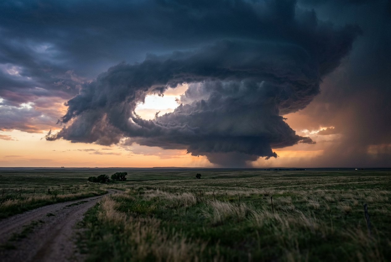
1. Opening Scene: The Breath of the Mesocyclone
To stand on the open expanse of the Great Plains in late spring when a severe supercell matures is to witness the atmosphere transform from a passive medium into a violent thermodynamic machine. The afternoon begins in heavy, breathless suspension. The air feels thick and oily against the skin, saturated with moisture surging northward from the Gulf of Mexico. The heat is oppressive, but the true signal of instability is invisible: an immense reservoir of convective available potential energy waiting for a trigger.
       [ MID-LEVEL DRY AIR INTRUSION ]
                    \
                     \   (Dynamic Suction & Evaporative Chilling)
                      v
  [ UPWARD ROTATING MESOCYCLONE ] <=== (Low-Level Inflow)
              |         \
 (Updraft)    |          \===> [ REAR-FLANK DOWNDRAFT (RFD) ]
     ^        |                      |
     |   [ WALL CLOUD ]              v
     |        |              [ CLEAR SLOT CARVED ]
     |   (Inflow Jet)                |
====(Surface)===================[ GUST FRONT / TORNADOGENESIS ]===
By late afternoon, the horizon curdles. A solitary convective tower breaches the capping inversion, its anvil erupting into the lower stratosphere like a volcanic plume. As you position yourself a few miles southeast of the storm core, the ambient sensations shift with unsettling speed. The barometric pressure on your digital altimeter drops steadily, then begins to stutter. The ambient wind blows warmly into your face from the southeast—a persistent, feeding inflow rushing toward the base of the updraft. The smell of ozone mingles with petrichor, the earthy scent of dry soil dampened by distant raindrops.
Then, the character of the storm fundamentally changes.
Beneath the rain-free base of the storm, a low-hanging pedestal of cloud—the wall cloud—begins to tilt and rotate with perceptible angular velocity. But the most dramatic transformation occurs not in the ascending air, but behind it. Just to the rear of the rotating cloud base, a brilliant crescent of sunlight slices through the murk. The cloud deck appears to be mechanically excavated, carved out from above by an invisible hand. This bright horseshoe notch—known to meteorologists as the clear slot—widens as descending air violently clears the cloud droplets.
Simultaneously, the sensory environment turns hostile. The warm, humid inflow at your back is abruptly replaced by an icy, turbulent blast surging from the west-northwest. The temperature plunges ten degrees Celsius in under thirty seconds. Rain and hail, wrapped into a sweeping spiral around the back of the updraft, begin to lash the ground. Above you, along the boundary where this cold descending blast grinds against the roaring upward suction, a tight, horizontal cylinder of turbulent cloud begins to roll, tilt, and stretch into the vertical. The descent has commenced: the rear-flank downdraft has engaged the surface, dragging the mid-level rotation of the storm down to the earth.
2. What Is Actually Happening: Plain English First
To understand the rear-flank downdraft (RFD), one must dismantle the common misconception that severe thunderstorms are merely towering chimneys of rising warm air. A mature supercell thunderstorm is a coupled system consisting of a persistent, rotating updraft—the mesocyclone—and two primary downdrafts: the forward-flank downdraft (FFD), which carries the bulk of the storm’s heavy rain and hail ahead of the path, and the rear-flank downdraft (RFD), which wraps around the backside of the rotating updraft core.
              NORTH / FORWARD FLANK
        +---------------------------------+
        |  Heavy Rain & Hail Core (FFD)   |
        +---------------------------------+
                        ^
                        |  Precipitation Outflow
                        |
   WEST / REAR          |          EAST / INFLOW
+-----------------+     |     +---------------------+
| Rear-Flank      |  (MESO)   | Warm, Moist Inflow  |
| Downdraft (RFD) | =========>| Low-Level Jet (LLJ) |
| & Clear Slot    |  Updraft  +---------------------+
+-----------------+     |
        \               |
         \---> [ HOOK ECHO ] <--- Dynamic Vortex Wraps
The Sinking Plume: A Tale of Two Forces
Why does air plunge downward out of the sky behind the updraft? Think of the atmosphere as a layered cake, where each layer has a distinct temperature, humidity, and speed. Near the ground, the air is warm, buoyant, and moist. Several miles aloft, in the mid-troposphere, the air is dry, frigid, and racing rapidly eastward.
The supercell’s updraft acts like a massive pillar obstruction in this mid-level atmospheric river. As dry mid-level air collides with the western flank of the storm, two distinct physical mechanisms force it to plunge toward the ground:
- The Chilling Waterfall (Thermal and Hydrometeor Loading): When rain and hail from the storm core are slung into this dry mid-level air, the water droplets instantly begin to evaporate and the hailstones begin to melt and sublimate. Evaporation requires heat energy, which is extracted directly from the surrounding air. As the air chills, it contracts, becomes significantly denser than its environment, and begins to fall. Simultaneously, the physical weight of millions of tons of suspended hail and raindrops drags the air downward like a descending freight elevator.
- The Bathtub Drain Effect (Dynamic Cyclostrophic Suction): Sinking is not just caused by gravity pulling dense air down; it is also driven by pressure sucking it down. At mid-levels, the storm’s mesocyclone is spinning with fierce intensity. Just as water swirling rapidly down a bathtub drain creates a depression in the center of the whirlpool, intense rotation in the atmosphere generates a powerful localized drop in pressure. This dynamic low pressure aloft creates a vertical suction force that draws mid-tropospheric air down into the lower levels of the storm.
The Radar Hook Echo and the Visual Clear Slot
As the RFD plummets toward the earth, it encounters the rotating wind field of the mesocyclone. The downdraft does not simply drop straight down; it is caught in the storm's cyclonic circulation and swept in a sweeping arc around the southern and eastern flanks of the updraft.
On a meteorological radar screen (such as those operated by the National Severe Storms Laboratory (NSSL)), this curtain of descending precipitation, wrapped around the rain-free updraft, produces the iconic hook echo. The hook is the radar's photographic signature of the RFD physically wrapping rain and hail around the storm's rotating core.
Visually, as this dry mid-level air descends, it compresses under increasing atmospheric pressure and warms adiabatically. This warming causes any suspended cloud droplets within the descending column to evaporate almost instantly. To an observer on the ground, this creates the clear slot—a dramatic, horseshoe-shaped notch of bright sky that eats into the back of the wall cloud.
The Paradox of Tornadogenesis: Cold vs. Warm RFDs
For decades, atmospheric scientists asked a fundamental question: if tornadoes form beneath roaring updrafts, why is a downdraft necessary to produce a tornado?
The answer lies in the physics of rotation. An updraft is excellent at stretching existing spin vertically, but because air is moving away from the ground, an updraft alone cannot transport vertical rotation down to the surface. It requires a downdraft to carry mid-level angular momentum downward to ground level.
However, this presents a delicate thermodynamic balance, formalized by atmospheric scientist Paul Markowski and documented in the AMS Glossary of Meteorology:
- The Cold, Choked RFD: If the descending air is too cold and negatively buoyant (due to excessive evaporation in an overly dry environment), the air hits the ground like a block of lead and spreads out aggressively as a cold outflow dome. This cold air undercuts the updraft, acts like cold syrup spreading across a table, and snuffs out the storm's low-level suction before a tornado can form.
- The Warm, Buoyant RFD: Conversely, if the downdraft is only mildly cooler (or even dynamically warmed) relative to the ambient air, it reaches the ground while maintaining low-density buoyancy. The co-located low-level updraft can immediately ingest this newly arrived surface rotation, stretching it upward like a figure skater pulling in their arms, collapsing the radius of spin from hundreds of meters down to tens of meters, and unleashing a violent tornado.
3. The Science: Mathematical Formulations and Proofs
For meteorologists and dynamicists, the behavior of the rear-flank downdraft is governed by precise kinematic and thermodynamic equations. We examine the two governing frameworks: vertical acceleration forcing and baroclinic vorticity generation.
Part A: The Dual Forcing Equation of the RFD
The vertical acceleration of an air parcel ($\frac{dw}{dt}$) within the rear-flank downdraft is governed by the vertical momentum equation in perturbation form:
$$\frac{dw}{dt} = -\frac{1}{\rho}\frac{\partial p'}{\partial z} + B$$
Where $\rho$ is ambient air density, $p'$ is the dynamic perturbation pressure, $z$ is the vertical coordinate, and $B$ is the total buoyancy force per unit mass.
Expanding the buoyancy term $B$ into its thermodynamic and hydrometeor loading components:
$$B = g \left( \frac{\theta_v'}{\theta_{v0}} \right) - g q_h$$
Here, $g$ is the acceleration due to gravity ($9.81\text{ m/s}^2$), $\theta_v'$ is the perturbation virtual potential temperature (accounting for temperature deficits and water vapor), $\theta_{v0}$ is the base-state virtual potential temperature, and $q_h$ is the hydrometeor mixing ratio (mass of liquid and solid water per unit mass of dry air, in $\text{kg/kg}$).
[ TOTAL DOWNWARD ACCELERATION: dw/dt ]
  = [ DYNAMIC PRESSURE GRADIENT: -(1/rho)*(dp'/dz) ]  <-- Cyclostrophic Suction
  + [ THERMAL BUOYANCY: g * (theta_v' / theta_v0) ]    <-- Evaporative Chilling
  - [ HYDROMETEOR LOADING: g * q_h ]                   <-- Weight of Precipitation
The dynamic perturbation pressure $p'$ arises from the three-dimensional wind field via the diagnostic pressure perturbation Poisson equation:
$$\nabla^2 p' = -\rho \left[ \left( \frac{\partial u}{\partial x} \right)^2 + \left( \frac{\partial v}{\partial y} \right)^2 + \left( \frac{\partial w}{\partial z} \right)^2 + 2\frac{\partial u}{\partial y}\frac{\partial v}{\partial x} + 2\frac{\partial u}{\partial z}\frac{\partial w}{\partial x} + 2\frac{\partial v}{\partial z}\frac{\partial w}{\partial y} \right]$$
In a rapidly rotating mesocyclone, the nonlinear cross-term $2\rho\left(\frac{\partial u}{\partial y}\frac{\partial v}{\partial x}\right)$ dominates, reducing locally to the cyclostrophic balance:
$$p'(r) \approx -\int_r^\infty \rho \frac{v_\theta^2(r')}{r'} dr'$$
Where $v_\theta$ is the tangential rotational velocity. Because $v_\theta$ peaks in the mid-troposphere ($z \approx 3\text{--}5\text{ km}$), an intense negative pressure perturbation ($p' < 0$) develops aloft. At the ground ($z = 0$), rotation is initially weak, so $p' \approx 0$. This sets up a downward-directed vertical dynamic pressure gradient force ($-\frac{1}{\rho}\frac{\partial p'}{\partial z} < 0$), actively sucking mid-level air toward the surface regardless of its thermal buoyancy.
Worked Numerical Example 1: Calculating Parcel Acceleration in the RFD
Let us evaluate the instantaneous downward acceleration ($\frac{dw}{dt}$) of a parcel at an altitude of $z = 2{,}500\text{ m}$ descending within the rear-flank downdraft core of a high-end supercell.
- Ambient reference temperature: $\theta_{v0} = 300.0\text{ K}$
- Evaporatively chilled perturbation: $\theta_v' = -3.5\text{ K}$
- Precipitation loading (heavy rain/hail mixture): $q_h = 0.006\text{ kg/kg}$ ($6.0\text{ g/kg}$)
- Dynamic perturbation pressure gradient: $-\frac{1}{\rho}\frac{\partial p'}{\partial z} = -0.045\text{ m/s}^2$
- Gravitational acceleration: $g = 9.81\text{ m/s}^2$
Step 1: Compute the Thermal Buoyancy Force ($B_{\text{thermal}}$)
$$B_{\text{thermal}} = g \left( \frac{\theta_v'}{\theta_{v0}} \right) = 9.81 \times \left( \frac{-3.5}{300.0} \right) = 9.81 \times (-0.011667) = -0.1145\text{ m/s}^2$$
Step 2: Compute the Hydrometeor Loading Force ($B_{\text{loading}}$)
$$B_{\text{loading}} = -g \times q_h = -9.81 \times 0.006 = -0.0589\text{ m/s}^2$$
Step 3: Sum the Total Buoyancy ($B_{\text{total}}$)
$$B_{\text{total}} = B_{\text{thermal}} + B_{\text{loading}} = -0.1145 - 0.0589 = -0.1734\text{ m/s}^2$$
Step 4: Combine with the Dynamic Pressure Gradient Force
$$\frac{dw}{dt} = \left( -\frac{1}{\rho}\frac{\partial p'}{\partial z} \right) + B_{\text{total}} = -0.045 + (-0.1734) = -0.2184\text{ m/s}^2$$
Part B: Baroclinic Vorticity Generation, Tilting, and Stretching
Vertical spin cannot spontaneously generate out of nothing on flat ground without horizontal shear or temperature gradients. Along the leading edge of the RFD (the RFD gust front), a sharp horizontal temperature gradient exists between the cool descending outflow and the warm ambient inflow.
       WARM INFLOW AIR (High Buoyancy: B+)
                      ^
                      |  Density Discontinuity creates Baroclinic Torque
                      v
       COOL RFD OUTFLOW (Low Buoyancy: B-)
       ----------------------------------------------------
       ==> Horizontal Vortex Line Generated: w_h = curl(B)
       ==> Updraft Tilts Vortex Line into Vertical (zeta)
       ==> Vertical Convergence Stretches zeta into Tornado
According to Bjerknes' circulation theorem and the curl of the momentum equation, a horizontal gradient in buoyancy generates horizontal vorticity ($\boldsymbol{\omega}_h = \omega_x \mathbf{i} + \omega_y \mathbf{j}$):
$$\frac{d\boldsymbol{\omega}_h}{dt} = \nabla \times \mathbf{B} = \left( -\frac{\partial B}{\partial y} \right) \mathbf{i} + \left( \frac{\partial B}{\partial x} \right) \mathbf{j}$$
As this baroclinically generated horizontal vortex tube is swept along the ground toward the storm's low-level updraft, it is acted upon by the three-dimensional vertical vorticity equation:
$$\frac{\partial \zeta}{\partial t} = -\underbrace{\mathbf{v} \cdot \nabla(\zeta + f)}{\text{Advection}} + \underbrace{\left( \boldsymbol{\omega}_h \cdot \nabla \right) w}{\text{Tilting}} + \underbrace{(\zeta + f)\frac{\partial w}{\partial z}}_{\text{Stretching}}$$
Where: * $\zeta = \frac{\partial v}{\partial x} - \frac{\partial u}{\partial y}$ is the vertical component of relative vorticity. * $f = 2\Omega \sin\phi$ is the Coriolis parameter. * $\left(\boldsymbol{\omega}_h \cdot \nabla\right) w = \omega_x \frac{\partial w}{\partial x} + \omega_y \frac{\partial w}{\partial y}$ represents the tilting of horizontal vortex lines into the vertical by horizontal gradients of the updraft velocity. * $(\zeta + f)\frac{\partial w}{\partial z}$ represents the stretching of vertical vortex columns by vertical velocity convergence ($\frac{\partial w}{\partial z} > 0$).
Worked Numerical Example 2: The Kinematic Spin-Up of a Low-Level Vortex
Consider a parcel of air entering the low-level mesocyclone along the RFD gust front:
- Initial horizontal baroclinic vorticity: $\omega_x = 0.025\text{ s}^{-1}$ (aligned perpendicular to the updraft gradient)
- Horizontal updraft gradient: $\frac{\partial w}{\partial x} = 0.012\text{ s}^{-1}$
- Initial background vertical vorticity: $\zeta_0 = 0.008\text{ s}^{-1}$
- Low-level vertical velocity stretch rate (updraft acceleration): $\frac{\partial w}{\partial z} = 0.025\text{ s}^{-1}$
- Coriolis parameter: $f \approx 1.0 \times 10^{-4}\text{ s}^{-1}$ (negligible on storm scales relative to $\zeta$)
Step 1: Calculate the Tilting Production Rate ($\text{Rate}_{\text{tilt}}$)
$$\text{Rate}_{\text{tilt}} = \omega_x \frac{\partial w}{\partial x} = 0.025 \times 0.012 = 3.00 \times 10^{-4}\text{ s}^{-2}$$
Step 2: Calculate the Stretching Production Rate ($\text{Rate}_{\text{stretch}}$)
$$\text{Rate}_{\text{stretch}} = (\zeta_0 + f)\frac{\partial w}{\partial z} \approx (0.008 + 0.0001) \times 0.025 = 0.0081 \times 0.025 = 2.025 \times 10^{-4}\text{ s}^{-2}$$
Step 3: Total Instantaneous Local Vorticity Tendency ($\frac{\partial \zeta}{\partial t}$)
$$\frac{\partial \zeta}{\partial t} \approx \text{Rate}{\text{tilt}} + \text{Rate}{\text{stretch}} = 3.00 \times 10^{-4} + 2.025 \times 10^{-4} = 5.025 \times 10^{-4}\text{ s}^{-2}$$
4. Practical Outdoor Guidance: Field Observations and Radar Warning Operations
Whether analyzing storms from the cockpit of a Doppler radar truck or monitoring conditions on a farm, identifying the lifecycle of the rear-flank downdraft is critical for severe weather safety and real-time operations.
+-------------------------------------------------------------------------+
|                    RADAR AND VISUAL DIAGNOSTIC MATRIX                   |
+--------------------------+-----------------------+----------------------+
| Diagnostic Feature       | Visual Appearance     | Radar Signature      |
+--------------------------+-----------------------+----------------------+
| Mesocyclone Updraft      | Rotating Wall Cloud   | BWER / Inflow Notch  |
| RFD Initiation           | Clear Slot Excavation | Rear Inflow Jet      |
| Mature RFD Wrapping      | Horseshoe Cloud Base  | Hook Echo Wrapping   |
| Tornadogenesis Imminent  | Rapid Ground Rotation | Velocity Couplet/TDS |
+--------------------------+-----------------------+----------------------+
Visual Signatures for the Ground Observer
- The Horseshoe Carve: Watch the rear quadrant of the wall cloud. If you see cloud base material thinning, shredding, and dissolving to reveal blue sky or bright sunlit cloud behind the rotation, the RFD has reached low levels. This is the visual manifestation of adiabatic warming evaporating the condensed moisture.
- Scud Ingestion Vectors: Observe the movement of low-hanging, ragged clouds (scud). If scud fragments near ground level are moving rapidly away from the clear slot and into the center of the rotating wall cloud, the RFD gust front is successfully converging with the updraft.
- The RFD Gust Front Dust Roll: Look at the ground beneath the clear slot. A vigorous RFD will kick up a curved arc of dust or spray before any condensation funnel reaches the ground. This indicates the vortex has already coupled with the surface.
                    [ MESOCYCLONE UPDRAFT ]
                             /   |
                            /    | (Updraft Core)
                           /     v
 [ CLEAR SLOT ]           /  [ WALL CLOUD ]
   (Sunlit Blue Sky)     /       |
          \             /        |
           v           v         v
==================[ DUST RING / SURFACE TORNADO ]==================
Instrument Signatures to Monitor
- The Barometric Signature: An initial steady fall in pressure (the storm's meso-low) is followed by a sudden, jagged upward spike of $1\text{--}3\text{ hPa}$ as the dense RFD cold pool arrives (the "meso-high" or "wake depression").
- Thermal Deficit: Monitor the wet-bulb temperature. If the temperature drops more than $6^\circ\text{C}$ below the ambient inflow temperature during the RFD surge, the downdraft is excessively cold and likely to produce severe straight-line winds rather than a long-track tornado (Markowski criterion). A temperature drop of only $1\text{--}3^\circ\text{C}$ indicates high tornadic potential.
- Surface Wind Shift: Ambient inflow typically blows from the south or southeast ($130^\circ\text{--}170^\circ$). When the RFD surges, wind abruptly veers to the west-southwest or northwest ($240^\circ\text{--}310^\circ$) with sudden extreme gusts exceeding $25\text{ m/s}$ ($55\text{ mph}$).
SURFACE WIND VECTORS:
Ambient Inflow:     <=== (Warm / Moist from SE at 15 m/s)
RFD Outflow Blast:  ===> (Cool / Veering from WNW at 30 m/s)
Operational Radar Analysis: Decoding the Hook and Couplet
In modern warning meteorology, as practiced by the Met Office and the National Weather Service (documented in the NOAA Radar Operations Center), radar analysts cross-reference three primary dual-polarization radar products:
+-------------------------------------------------------------------------+
|                  WSR-88D DUAL-POLARIZATION RADAR PANEL                  |
+------------------------------------+------------------------------------+
| REFLECTIVITY (Z):                  | STORM-RELATIVE VELOCITY (SRM):     |
| High dBZ pendant wrapping in hook  | Inbound (green) / Outbound (red)   |
| around Bounded Weak Echo Region    | tight cyclonic velocity couplet    |
+------------------------------------+------------------------------------+
| CORRELATION COEFFICIENT (CC / rho):| DIFFERENTIAL REFLECTIVITY (ZDR):   |
| Sharp drop (< 0.80) at hook tip    | Low/negative values indicating     |
| confirming Tornadic Debris (TDS)   | tumbling non-meteorological debris |
+------------------------------------+------------------------------------+
- Base Reflectivity ($Z$): Identify the hook echo in the right-rear quadrant of the storm. The hook is formed as the RFD draws rain and hail around the Bounded Weak Echo Region (BWER)—the echo-free vault where the updraft is so ferocious that water droplets do not have time to grow to radar-detectable size before being lofted aloft.
- Storm-Relative Velocity (SRM): Look for a tight velocity couplet (adjacent bins of bright green inbound velocities and bright red outbound velocities). The interface between these opposing velocity maxima defines the mesocyclone center. When the RFD reaches the surface, this couplet contracts in diameter and increases in gate-to-gate shear, often exceeding $\Delta V > 40\text{ m/s}$ ($80\text{ knots}$) over distances under $1\text{ nautical mile}$.
- Correlation Coefficient ($\rho_{hv}$): A localized drop in correlation coefficient below $0.80$, exactly co-located with the tip of the hook echo and the velocity couplet, confirms a Tornadic Debris Signature (TDS). This indicates that the RFD-induced vortex has made ground contact and is lofting non-meteorological debris (foliage, structural material, soil) into the circulation.
5. Today's Meteorological Rule of Thumb
When the sky carves a bright crescent of blue behind a rotating cloud base, never mistake the arriving sunlight for safety: the storm is breathing downward, using dynamic suction and thermal torque to pull its spinning core directly to the earth.