Overshooting Tops & Above-Anvil Cirrus Plumes: How Stratospheric Penetration and Gravity Wave Breaking Unmask Severe Storm Cores
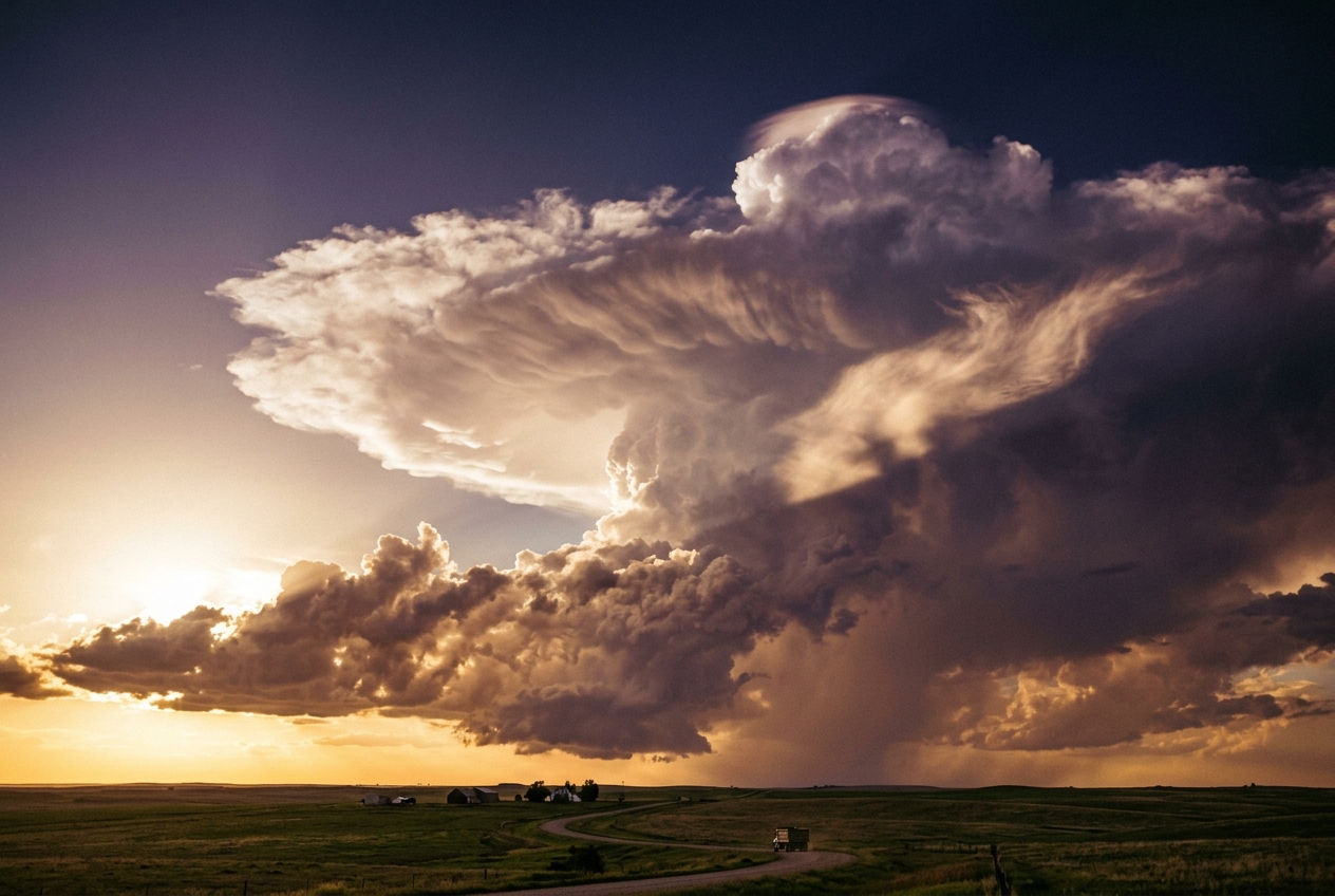
On a stifling July afternoon across the open plains, the atmosphere feels taut, primed, and heavy with unspoken intent. The grass is dry, ticking faintly in the dead heat, but the air carries a humid, mineral tang—the scent of ozone and parched soil anticipating water. To the west, the horizon has long ceased to be blue. A towering cumulonimbus cloud has grown over the last hour from a loose cluster of innocent cumulus congestus into a monolithic white fortress, its summit expanding laterally until it strikes an invisible ceiling ten miles above the earth.
To an observer watching from thirty miles away, the storm’s upper periphery spreads into a vast, radial anvil of brilliant, fibrous ice crystals. The cloud flattens with mathematical precision against the tropopause—the thermodynamic boundary separating the turbulent troposphere below from the tranquil stratosphere above. Yet, at the center of this frozen tableland, the calm is violently shattered. A furious, cauliflower-textured dome erupts from the flat anvil shield. It does not spread; it punches directly upward, boiling into the deep azure of the lower stratosphere like an underwater volcanic detonation.
For four or five minutes, this overshooting top climbs miles beyond the cloud’s natural ceiling, its crisp, hard-edged convolutions catching the stark sunlight. Then, as its vertical momentum exhausts itself against the stable stratospheric air, the dome collapses back into the anvil with catastrophic speed, sending concentric gravity waves rippling outward across the icy deck. Downstream of the collapsing core, a shredded, plume-like wake of high-altitude cirrus drifts across the top of the anvil—an Above-Anvil Cirrus Plume (AACP). Below this celestial spectacle, hidden within the rain-cooled gloom of the storm's core, golf-ball-sized hail and tornadic vortices are churning toward the surface.
What Is Actually Happening? The Physics in Plain English
To understand why a thunderstorm can punch through the roof of our weather layer, think of the atmosphere not as empty space, but as a vast, layered fluid—like warm oil resting atop cold water in a glass, or a dense stack of blankets.
In the lowest layer of the atmosphere, the troposphere, the air generally grows colder the higher you climb. When the summer sun bakes the earth, it warms parcels of moist air near the surface. Because warm air is less dense than the cooler air surrounding it, it rises, exactly like a hot-air balloon or a cork released from the bottom of a swimming pool. As this moist parcel ascends, it expands under decreasing atmospheric pressure and cools. The water vapor inside condenses into liquid droplets, releasing an immense quantity of latent heat. This released heat keeps the interior of the cloud warmer than the surrounding environmental air, sustaining its upward buoyancy.
                                  [Lower Stratosphere]
                                   Air warms with height
                                   (Strongly Stable Layer)
              - - - - - - - - - - - - - - - - - - - - - - - - - - - - - - -
              ==================== TROPOPAUSE / EL ========================
              - - - - - - - - - - - - - - - - - - - - - - - - - - - - - - -
                                  [Upper Troposphere]
                                   Air cools with height
                                   (Unstable / Buoyant Ascent)
Eventually, this rising fountain of air reaches the Equilibrium Level (EL), situated right at the tropopause. Here, the temperature of the rising air parcel matches the temperature of the surrounding atmosphere. Just above this boundary lies the stratosphere, where the temperature trend reverses: ozone absorbs ultraviolet radiation, causing the stratosphere to become warmer with increasing height.
Because the stratosphere is warmer than the troposphere beneath it, it acts as a rigid thermodynamic lid. When ordinary clouds hit this boundary, their upward buoyancy drops to zero; unable to rise further, they spread out sideways, forming the familiar flat anvil shield recognized by meteorologists at the World Meteorological Organization.
However, a severe supercell thunderstorm is no ordinary cloud. By the time the air inside the storm’s central updraft reaches the equilibrium level, it is not merely floating upward—it is traveling vertically at speeds exceeding 100 miles per hour (45 to 60 meters per second). Like a speeding freight train hitting a level track, or a high-speed submarine breaching the ocean surface into the open air, the updraft possesses enormous kinetic momentum. It cannot simply stop at the boundary line.
Instead, the updraft overshoots, violently penetrating miles into the stable stratosphere. The moment it enters this warmer layer, the parcel becomes drastically colder and heavier than the stratospheric air around it. Negative buoyancy acts like a powerful hydraulic brake, dragging the vertical velocity down to zero. Once its momentum is spent, the dense, frozen turret plunges back down, smashing into the anvil top like a boulder dropped into a pond.
When the horizontal winds in the lower stratosphere shear across this protruding obstacle, they strip ice and water vapor from the summit. This high-altitude moisture is injected directly into the stratosphere, forming an elongated, wispy cloud known as an Above-Anvil Cirrus Plume (AACP), documented extensively by researchers at the NASA Earth Observatory.
The Science: Thermodynamics, Momentum, and Stratospheric Dynamics
For meteorologists and atmospheric physicists, the overshooting top is not merely a visual oddity; it is a direct kinematic probe of the storm’s convective engine. By analyzing the thermodynamics of the updraft and the fluid mechanics of the lower stratosphere, we can quantitatively predict how high a storm will penetrate into the stratosphere and what that penetration reveals about the storm's severity.
+-----------------------------------------------------------------------------+
|                          THERMODYNAMIC SUMMARY BOX                          |
|                                                                             |
|  1. Updraft Kinetic Energy:  w_max = sqrt( 2 * CAPE )                       |
|  2. Negative Buoyancy:       B = g * [ (theta_parcel - theta_env)           |
|                                        / theta_env ] < 0                    |
|  3. Stratospheric Stability: N = sqrt[ (g / theta_env)                      |
|                                        * (d(theta_env) / dz) ]              |
|  4. Overshoot Height:        Δz ≈ w_EL / N                                  |
+-----------------------------------------------------------------------------+
1. Parcel Acceleration and Updraft Velocity
The fundamental energy source driving deep moist convection is Convective Available Potential Energy (CAPE), defined as the vertically integrated positive buoyant energy of an air parcel ascending from its Level of Free Convection (LFC) to its Equilibrium Level (EL).
In plain language: CAPE represents the total amount of buoyant energy available to accelerate an air parcel upward through the troposphere.
Mathematically, CAPE is expressed via the integral of buoyancy $B$:
$$\text{CAPE} = \int_{z_{\text{LFC}}}^{z_{\text{EL}}} B \, dz = g \int_{z_{\text{LFC}}}^{z_{\text{EL}}} \left( \frac{T_{v,\text{parcel}} - T_{v,\text{env}}}{T_{v,\text{env}}} \right) dz$$
where: - $g$ is the acceleration due to gravity ($9.81\text{ m/s}^2$), - $T_{v,\text{parcel}}$ is the virtual temperature of the rising parcel (which accounts for the buoyant effect of water vapor), - $T_{v,\text{env}}$ is the virtual temperature of the ambient environment.
By invoking the conservation of mechanical energy—neglecting aerodynamic drag, water vapor loading, and turbulent entrainment of dry environmental air—the potential energy represented by CAPE is completely converted into kinetic energy ($\frac{1}{2} w^2$). This yields the classical equation for maximum theoretical updraft velocity ($w_{\max}$):
$$w_{\max} = \sqrt{2 \cdot \text{CAPE}}$$
Worked Example: Estimating Updraft Speed
Consider an intensely unstable spring atmosphere over the Great Plains, where thermodynamic soundings measured by the NOAA National Severe Storms Laboratory record a CAPE value of $3,200\text{ J/kg}$.
Substituting this value into our velocity equation:
$$w_{\max} = \sqrt{2 \cdot 3200\text{ J/kg}} = \sqrt{6400} = 80\text{ m/s} \quad (\approx 288\text{ km/h}\text{ or }179\text{ mph})$$
In real-world storms, hydrometeor water loading (the weight of suspended rain and hail) and turbulent mixing with ambient air reduce this maximum speed by approximately 30% to 50%. Even with these frictional dampening effects, actual core vertical velocities at the Equilibrium Level ($w_{\text{EL}}$) frequently reach $40\text{ to }55\text{ m/s}$.
2. The Stratospheric Deceleration and Penetration Height
When the updraft reaches the Equilibrium Level ($z_{\text{EL}}$), its buoyancy vanishes ($B = 0$). However, because the parcel possesses a massive vertical velocity $w_{\text{EL}}$, it crosses the tropopause into the lower stratosphere.
Inside the stratosphere, the environmental potential temperature $\theta_{\text{env}}$ increases sharply with height ($d\theta_{\text{env}} / dz > 0$), creating a strongly stratified, stable thermodynamic profile. As our cloudy air parcel continues to ascend, it expands and cools dry-adiabatically (or moist-adiabatically if condensation continues), causing its potential temperature $\theta_{\text{parcel}}$ to remain virtually constant while the surrounding air grows hotter.
Consequently, the parcel experiences strong negative buoyancy:
$$B = g \left( \frac{\theta_{\text{parcel}} - \theta_{\text{env}}}{\theta_{\text{env}}} \right) < 0$$
This negative buoyancy acts as a restoring force. The vertical equation of motion for the parcel within the stratosphere can be modeled as a classical harmonic oscillator:
$$\frac{d^2 z}{dt^2} = - N^2 (z - z_{\text{EL}})$$
where $N$ is the Brunt–Väisälä Frequency (the natural buoyancy oscillation frequency of the stratified fluid), defined as:
$$N = \sqrt{\frac{g}{\theta_{\text{env}}} \frac{d\theta_{\text{env}}}{dz}}$$
Integrating this differential equation from the equilibrium level ($z = z_{\text{EL}}$, where $w = w_{\text{EL}}$) to the maximum apex of the dome ($w = 0$) yields the theoretical maximum penetration height $\Delta z$:
$$\Delta z = z_{\text{top}} - z_{\text{EL}} \approx \frac{w_{\text{EL}}}{N}$$
This elegant relationship demonstrates that the penetration height of an overshooting top is directly proportional to the vertical velocity of the updraft entering the stratosphere, and inversely proportional to the static stability of the stratospheric layer.
Worked Numerical Walkthrough: Calculating Overshoot Height
Let us calculate the physical height to which an overshooting top will punch above its anvil: - Updraft Velocity at EL ($w_{\text{EL}}$): $45\text{ m/s}$ (a robust supercell updraft) - Stratospheric Stability ($N$): $0.020\text{ s}^{-1}$ (typical for the lower stratosphere, corresponding to a buoyancy oscillation period $\tau = \frac{2\pi}{N} \approx 314\text{ seconds}$, or roughly 5 minutes)
Applying the penetration height formula:
$$\Delta z = \frac{45\text{ m/s}}{0.020\text{ s}^{-1}} = 2,250\text{ meters} \quad (\approx 2.25\text{ km}\text{ or }7,380\text{ feet})$$
Key Result: A storm updraft surging at $45\text{ m/s}$ will penetrate more than 2.2 kilometers (7,380 feet) straight into the stratosphere above the anvil deck before gravity halts its ascent.
3. Thermal Anomalies and Infrared Satellite Signatures
The thermodynamic consequence of this stratospheric penetration is dramatic. As the overshooting parcel is forced upward against its negative buoyancy, it undergoes intense adiabatic expansion, cooling at roughly $9.8^\circ\text{C}$ per kilometer.
If the ambient tropopause temperature is $-60^\circ\text{C}$ ($213\text{ K}$), an air parcel that overshoots by $2.25\text{ km}$ cools adiabatically to an astonishing $-82^\circ\text{C}$ ($191\text{ K}$).
On infrared satellite imagery from geostationary platforms like NOAA's GOES-R series, this creates a distinct thermal footprint:
- The Cold "U" or "Enhanced-V" Signature: The overshooting top appears as a localized island of extreme thermal coldness (bright white or purple on enhanced color tables) embedded within the warmer anvil cloud. The stratospheric winds deflect around this rigid dome, channeling downstream in a divergent "V" shape.
- The Warm Wake and Above-Anvil Cirrus Plumes (AACPs): As high-velocity stratospheric winds shear across the top of the cold dome, they generate intense Kelvin-Helmholtz instability and breaking gravity waves (similar to ocean waves crashing over a shallow reef). This wave breaking mixes warm stratospheric air downward into the wake of the dome while stripping ice crystals and water vapor from the updraft.
- Stratospheric Moistening: This process injects water vapor directly into the arid stratosphere. The resulting cirrus plume drifts downstream atop the anvil, appearing significantly warmer (by $5^\circ\text{C}$ to $15^\circ\text{C}$) on infrared satellite channels than the anvil below it, because it resides within the warmer stratospheric inversion layer.
Infrared Satellite View (Plan View):
               __________________________________
              /        Warm Anvil Shield        /
             /   \                          /  /
            /     \   Cold "U/V" Ring      /  /
           /       \  [-75°C to -85°C]    /  /
          /         \     .-----.        /  /
         /           \   (  OT   )      /  /
        /             '---\     /------'  /
       /                   '---'         /
      /             === Warm AACP ===>  /
     /             [-55°C to -60°C]    /
    /_________________________________/
4. Correlation with Severe Ground Phenomena
The physical characteristics of overshooting tops serve as an unmistakable diagnostic tool for severe weather on the ground. Research documented by the American Meteorological Society and the Met Office demonstrates clear correlations:
+-----------------------------------------------------------------------------+
|               OVERSHOOTING TOP DYNAMICS & SURFACE HAZARDS                   |
+------------------------------------+----------------------------------------+
| Morphological Feature              | Ground Hazard Correlation              |
+------------------------------------+----------------------------------------+
| Sustained Dome Duration > 15 min   | Long-track Supercell / Giant Hail (>5cm)|
| Rapid Pulsation (Period < 3 min)   | Cyclic Tornado Touchdown Potential     |
| Deep Penetration (Δz > 2.0 km)     | Extreme Wet/Dry Microbursts (>70 kts)  |
| Presence of Persistent AACP        | Enhanced EF2+ Tornadogenesis Risk      |
+------------------------------------+----------------------------------------+
- Giant Hail Production: Sustaining an overshooting top requires an updraft velocity of $40\text{ to }60\text{ m/s}$. This immense upward aerodynamic drag is the exact velocity required to suspend large ice stones in the supercooled liquid growth zone ($-10^\circ\text{C}$ to $-25^\circ\text{C}$), allowing them to accrete multiple layers of rime ice until they exceed golf-ball or baseball size.
- Severe Microbursts and Downbursts: The overshooting dome is drastically colder and denser than the stratospheric air around it. When the core updraft pulses or weakens, this massive column of suspended ice and cold air collapses downward under gravity. Enhanced by evaporative cooling as it falls through the dry mid-levels, this collapsing mass strikes the ground as a violent, destructive downburst.
- Tornadogenesis: A persistent, steadily rotating overshooting top indicates a dynamic balance between buoyant updraft acceleration and storm-scale vorticity tilting, a hallmark of mature, long-lived supercell mesocyclones.
Practical Outdoor Guidance: Reading the Sky
While meteorologists rely on dual-polarization radar and geostationary satellites, an observant person on the ground can glean profound insights into atmospheric instability simply by watching the sky and monitoring local instruments.
       ================= FIELD OBSERVER'S SCAN =================

       [ VISUAL ]      Is the summit crisp and bubbling (high kinetic energy),
                       or fuzzy and glaciated (decaying updraft)?

       [ BAROMETER ]   Rapid pressure drop followed by a sharp "thunderstorm
                       nose" (pressure spike) signals an approaching gust front.

       [ THERMOMETER ] Plunging surface temperatures indicate cold downdraft
                       air displacing the warm inflow boundary.
1. Visual Signatures in the Field
- Cauliflower Crispness vs. Glaciation: Look closely at the summit of the convective tower. If the bubbling dome has sharp, hard, cauliflower-like boundaries, the updraft is actively pumping liquid droplets and kinetic energy into the upper troposphere faster than the droplets can freeze into amorphous ice crystals. If the dome becomes fuzzy, fibrous, and silky, the updraft has choked, and the cloud is glaciating (turning entirely to ice crystals) and dissipating.
- Pulsing Behavior: Time the appearance and collapse of overshooting domes using a wristwatch. A new dome surging upward every 5 to 8 minutes indicates a healthy, cyclic multi-cell or supercell storm. A dome that remains continuously elevated for 15 to 30 minutes signifies an exceptionally violent, steady-state supercell updraft.
- Flanking Towers and Back-Sheared Anvils: If the anvil spreads backward against the prevailing high-altitude wind—creating a sharp, acute wedge pointing upwind—the storm possesses extreme upper-level divergence driven by a massive core updraft.
2. Monitoring Local Instruments
- Aneroid or Digital Barometer: Watch the barometric trend. As a storm approaches, atmospheric pressure will drop steadily. However, minutes before the storm's precipitation arrives, watch for the thunderstorm pressure nose—a sudden, sharp jump in pressure (often 2 to 4 hPa in under 10 minutes) caused by the massive, cold, dense downdraft slamming into the ground and spreading outward.
- Thermometer and Hygrometer: A sultry, stagnant afternoon where the dew point exceeds $18^\circ\text{C}\text{ to }22^\circ\text{C}$ ($65^\circ\text{F}\text{ to }72^\circ\text{F}$) provides the boundary-layer moisture fuel required for high CAPE values. A sudden, sharp drop in temperature of $10^\circ\text{C}$ ($18^\circ\text{F}$) or more accompanied by gusty winds indicates that the rain-cooled outflow boundary has arrived.
- Wind Direction (Anemometer / Wind Vane): In the Northern Hemisphere, if the surface wind is blowing from the southeast while mid-level clouds are moving from the southwest, the atmosphere exhibits strong directional wind shear—the critical ingredient for supercell rotation.
Today's Meteorological Rule of Thumb
The Rule of the Anvil Dome:
"If the anvil flattens, the storm has hit its ceiling; but if the center boils like a caulking kettle miles into the blue, seek shelter immediately—the engine room below is manufacturing giant hail, damaging winds, and tornadic shear."
Further Scientific Reading & Authoritative Meteorological Resources
- NOAA National Severe Storms Laboratory: Severe Weather Elements
- NASA Earth Observatory: Anatomy of an Overshooting Top
- World Meteorological Organization: International Cloud Atlas
- Met Office UK: Deep Convection and Thunderstorm Mechanics
- American Meteorological Society: Glossary of Meteorology - Overshooting Tops