Outflow Boundary Collisions & Arc Cloud Dynamics: How Intersecting Density Currents and Mechanical Lift Trigger Explosive Convective Storms
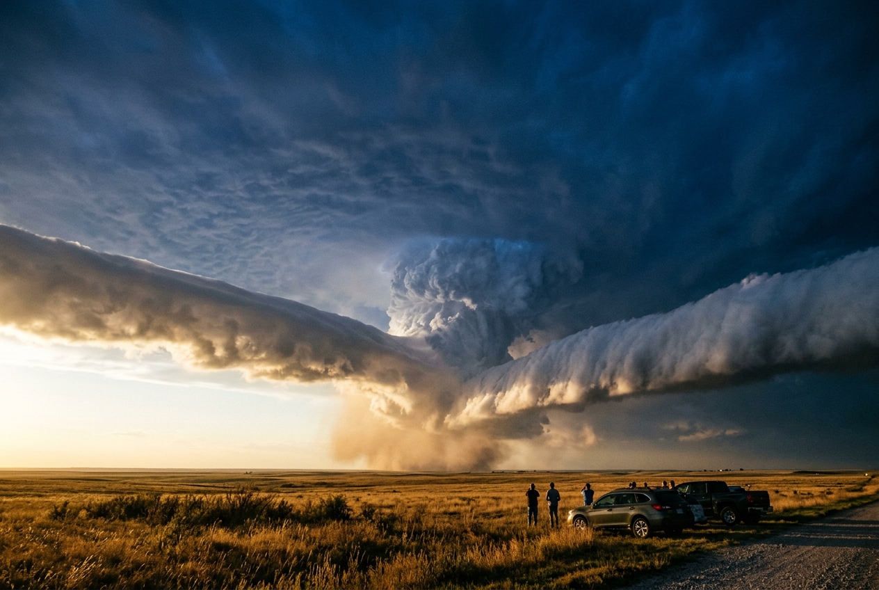
1. The Gathering Line: An Anatomy of Afternoon Silence
On a sweltering midsummer afternoon across the open plains, the atmosphere often presents an illusion of absolute tranquility. The sun hangs unimpeded in a pale azure sky; the air is thick, aromatic with the dry dust of cured wheat and baked topsoil. To the distant northwest and south, two decaying thunderstorm complexes, which had raged hours earlier over distant counties, have collapsed into broad, nebulous canopies of fibrous cirrus. Their anvil crowns have grown fuzzy, starved of the vigorous updrafts that birthed them. Underneath, no thunder rumbles, and no lightning branches toward the horizon. By all ordinary metrics of sensory perception, the severe weather threat appears to have dissolved into the humid afternoon calm.
Yet, if you stand quietly in the open field, look closely along the lower horizon.
Across the sun-drenched sky, two razor-thin, white, silken ribbons—known to atmospheric scientists as "rope clouds" or arcus filaments—are silently etching their way across the blue. One advances from the northwest; the other creeps steadily from the south-southwest. They appear almost delicate, like cigarette smoke drawn slowly across a sheet of blue glass. There is no precipitation falling from them, no dark, towering bellies of cumulonimbus, only these solitary, low-slung chalk lines hovering a mere thousand metres above the ground.
       [ Distant Decaying Storm A ]             [ Distant Decaying Storm B ]
                   \                                        /
     Cold Density   \  Rope Cloud A          Rope Cloud B  /  Cold Density
       Current       =====>                      <=====       Current
    =========================================================================
                          WARM, UNSTABLE BOUNDARY LAYER
As the two lines draw near, the ambient world begins to exhibit subtle, unsettling perturbations. The heavy, languid breeze suddenly dies, leaving the air eerily still. Then, without warning, the skin on the back of your neck prickles. A sudden cool draft, smelling acutely of ozone and damp loam—the classic scent of petrichor—cuts sharply through the oppressive heat, dropping the local temperature by four degrees Celsius in a handful of seconds. The grass, previously bent southward, flutters erratically, pauses, and abruptly snaps ninety degrees toward the northeast.
Directly overhead, where the two pale cloud ribbons are about to intersect, the sky ceases to be passive. The point of intersection begins to boil. The thin, wispy rope cloud thickens into a dense, turbulent roll; ragged cumulus humilis turrets suddenly vault upward with alarming velocity, erupting into a towering chimney of blinding white cauliflower-textured cloud. Within fifteen minutes, the silent, sunlit pasture is swallowed by the dark underbelly of a rapidly exploding secondary supercell.
What invisible engine orchestrated this violent, spontaneous resurrection of atmospheric convection from two dying storms? To understand this phenomenon, one must enter the domain of geophysical fluid dynamics, where the physics of density currents, vector kinematics, and mechanical buoyancy force the sky into explosive motion.
2. What Is Actually Happening: The Spilled Milk of the Sky
To understand how two dying storms can ignite a violent new one, we must strip away the atmospheric complexity and examine the fundamental behavior of fluids of differing densities.
Think of the lower atmosphere on a hot day as a vast, calm swimming pool filled with warm water. As a thunderstorm matures, rain falls through dry air beneath the cloud base. Some of this rain evaporates before reaching the ground. Evaporation is a cooling process—it consumes latent heat from the surrounding air, chilling it rapidly. Furthermore, the falling raindrops exert an aerodynamic drag, dragging this chilled air downward.
When this dense, refrigerated downdraft hits the flat ground, it cannot penetrate the earth. Instead, it behaves precisely like cold, heavy whole milk spilled onto the bottom of a shallow basin of warm water. It spreads out radially across the landscape as a shallow, fast-moving pool of high-density air, known formally as an outflow boundary or gust front.
              THUNDERSTORM CORE (Evaporative Chilling)
                             |
                             V  (Downdraft)
                  ___________|___________
                 /                       \
  (Cold Pool) <-- [h] Density Current [h] --> (Cold Pool)
 ==========================================================
Because cold air is denser than warm air, this advancing cold pool acts as a dynamic mechanical snowplow. It hugs the terrain, maintaining a sharp, wedge-like leading edge. As it bulldozes into the surrounding stagnant, warm, and humid air mass (the "warm sector"), it forces the lighter warm air up and over its sloping frontal head.
If this warm air contains sufficient moisture, the air cools as it is shoved upward, its water vapor condensing into a continuous, narrow, rolling line of condensation: the rope cloud or arcus line.
A single outflow boundary moving across a landscape often resembles a gentle hydraulic wave. It displaces air upward, but if the warm air is capped by a stable layer of warm, dry air aloft—what meteorologists refer to as an atmospheric "inversion" or "cap"—the lifted air cannot overcome this barrier. The displaced air simply spills back down behind the front, and the rope cloud remains an innocuous, transient smear in the sky.
However, when two distinct cold pools from separate storms advance toward one another, the physics undergoes a non-linear transformation. Where they collide, the ambient warm air caught between them has nowhere to escape horizontally. It is trapped in a vise. Squeezed from both sides by the converging wedges of dense air, the warm air is violently propelled straight upward in a concentrated, vertical jet. If that vertical thrust is sufficiently energetic, it smashes through the atmospheric cap like a hydraulic ram, unleashing the dormant convective energy stored in the atmosphere.
3. The Science: Density Currents, Vector Kinematics, and the Energy Deficit
To precisely model and predict these atmospheric collisions, we turn to the foundational equations of fluid dynamics and thermodynamic parcel theory.
3.1 The Hydraulic Speed of the Cold Pool Front
An atmospheric outflow boundary is governed by the physics of shallow gravity currents, first comprehensively modeled by T. B. Benjamin in 1968 and adapted for atmospheric thermodynamics by Wallace and Hobbs. The forward propagation velocity $c$ of the density current front relative to the ground is determined by the balance between the horizontal hydrostatic pressure gradient created by the cold pool and the ambient inertial resistance.
The frontal propagation speed is expressed as:
$$c = k \sqrt{g \, \frac{\Delta \theta_v}{\bar{\theta}_v} \, h}$$
Where: * $k$ is the internal Froude number (a non-dimensional parameter representing the ratio of inertial to gravitational forces, typically ranging between $0.7$ and $1.1$ for atmospheric gust fronts subject to surface friction and turbulent drag). * $g$ is the acceleration due to gravity ($9.81 \, \text{m s}^{-2}$). * $h$ is the physical vertical depth of the cold pool head (typically $500$ to $2,000 \, \text{m}$). * $\bar{\theta}v$ is the mean virtual potential temperature of the undisturbed ambient environment (measured in Kelvin, $\text{K}$). * $\Delta \theta_v = \bar{\theta}{v,\text{ambient}} - \theta_{v,\text{pool}}$ is the virtual potential temperature deficit of the evaporatively chilled cold pool.
Virtual Potential Temperature ($\theta_v$): The theoretical potential temperature dry air would have to possess to have the same density as the actual moist air parcel. Because water vapor has a lower molecular weight ($18.02 \, \text{g/mol}$) than dry air ($\approx 28.97 \, \text{g/mol}$), moist air is less dense than dry air at the same temperature and pressure. Virtual temperature accounts for both thermal and moisture effects on density in a single scalar value.
Worked Calculation: Estimating Boundary Speed
Suppose a dying multicell cluster over the southern plains produces an evaporatively cooled downdraft with the following measured boundary layer characteristics: * Ambient virtual potential temperature: $\bar{\theta}v = 305.0 \, \text{K}$ ($31.8^\circ\text{C}$) * Cold pool virtual potential temperature: $\theta{v,\text{pool}} = 299.0 \, \text{K}$ ($\Delta \theta_v = 6.0 \, \text{K}$) * Outflow boundary depth: $h = 1,200 \, \text{m}$ * Froude number calibrated for terrain roughness: $k = 0.85$
We evaluate the theoretical frontal speed:
$$c = 0.85 \times \sqrt{9.81 \times \left(\frac{6.0}{305.0}\right) \times 1,200}$$
$$c = 0.85 \times \sqrt{9.81 \times 0.01967 \times 1,200} = 0.85 \times \sqrt{231.57} = 0.85 \times 15.22 \, \text{m s}^{-1} \approx 12.94 \, \text{m s}^{-1}$$
Converting to kilometers per hour:
$$c \approx 12.94 \times 3.6 \approx 46.6 \, \text{km h}^{-1} \; (28.9 \, \text{mph})$$
This demonstrates that even a modest thermal deficit of $6 \, \text{K}$ drives a boundary propagating across the countryside at nearly $50 \, \text{km/h}$, retaining its cohesive structure for hours after the parent storm has dissipated.
3.2 Kinematics of Colliding Vector Fields and Explosive Uplift
When a single boundary propagates into quiescent air, it produces horizontal convergence along its leading edge. However, when two distinct density currents—propagating with velocity vectors $\mathbf{V}_1$ and $\mathbf{V}_2$—collide, the horizontal velocity field contracts abruptly over an extremely narrow spatial domain $\Delta x$.
Under the Boussinesq approximation for shallow atmospheric flows, the atmosphere behaves essentially as an incompressible fluid. The continuity equation in Cartesian coordinates dictates that mass must be conserved:
$$\frac{\partial u}{\partial x} + \frac{\partial v}{\partial y} + \frac{\partial w}{\partial z} = 0$$
Where $\mathbf{V}_h = (u, v)$ represents the horizontal velocity vector field, and $w$ represents the vertical velocity. Defining two-dimensional horizontal divergence as $\nabla_h \cdot \mathbf{V}_h = \frac{\partial u}{\partial x} + \frac{\partial v}{\partial y}$, we can solve directly for the vertical velocity gradient:
$$\frac{\partial w}{\partial z} = - \nabla_h \cdot \mathbf{V}_h$$
Integrating vertically from the earth's surface ($z = 0$, where surface boundary conditions require $w(0) = 0$) up to the top of the colliding cold pool depth $h$:
$$w(h) = \int_{0}^{h} \left( -\nabla_h \cdot \mathbf{V}_h \right) dz$$
Assuming the horizontal convergence $-\nabla_h \cdot \mathbf{V}_h$ is uniformly distributed throughout the shallow boundary layer depth $h$:
$$w(h) \approx \left( -\nabla_h \cdot \mathbf{V}_h \right) h$$
                         Vertical Jet: w(h)
                                 ^
                                 |
                                 |  [ Warm Updraft Chimney ]
                                 |
     Density Current 1 --->             <--- Density Current 2
    [ -u_1, Cold Pool ]    === COLLISION ===    [ +u_2, Cold Pool ]
   =================================================================
                                z = 0
The Magnitude of Collisional Forcing
Consider two opposing outflows, each possessing an internal frontal velocity of magnitude $|u| = 13 \, \text{m s}^{-1}$, meeting head-on along the x-axis ($v \approx 0$). The total velocity differential across the collision zone is:
$$\Delta u = u_1 - u_2 = 13 \, \text{m s}^{-1} - (-13 \, \text{m s}^{-1}) = 26 \, \text{m s}^{-1}$$
If this deceleration occurs across a turbulent collision zone width $\Delta x = 2,500 \, \text{m}$ for a cold pool of depth $h = 1,000 \, \text{m}$:
$$-\nabla_h \cdot \mathbf{V}_h \approx -\frac{\Delta u}{\Delta x} = \frac{26 \, \text{m s}^{-1}}{2,500 \, \text{m}} = 1.04 \times 10^{-2} \, \text{s}^{-1}$$
The resulting forced mechanical vertical velocity at the top of the boundary layer is:
$$w(h) \approx (1.04 \times 10^{-2} \, \text{s}^{-1}) \times (1,000 \, \text{m}) = 10.4 \, \text{m s}^{-1} \; (37.4 \, \text{km h}^{-1})$$
An upward mechanical velocity exceeding $10 \, \text{m s}^{-1}$ ($2,000 \, \text{ft/min}$) is a colossal hydrodynamic force. In the field of aviation, encountering such an ascent rate produces severe turbulence; in the field of convective dynamics, it represents an unstoppable piston capable of piercing the most stubborn thermal capping inversions.
3.3 Overcoming the Atmospheric Cap: The Energetics of Convective Initiation
Why is this intense mechanical uplift necessary? In typical pre-storm environments, the lower troposphere is characterized by a layer of Convective Inhibition (CIN). CIN represents the negative buoyant energy an ambient air parcel must overcome to rise from the surface ($z_{\text{sfc}}$) to its Level of Free Convection (LFC), above which the parcel becomes warmer than its surroundings and accelerates upward spontaneously via positive buoyancy.
The thermodynamic definition of Convective Inhibition is the path integral of negative buoyancy:
$$\text{CIN} = \int_{z_{\text{sfc}}}^{\text{LFC}} g \left( \frac{\theta_{v,\text{env}}(z) - \theta_{v,\text{parcel}}(z)}{\theta_{v,\text{env}}(z)} \right) dz$$
Where $\text{CIN}$ is expressed in Joules per kilogram ($\text{J kg}^{-1}$).
For spontaneous deep moist convection to initiate, an air parcel must possess sufficient kinetic energy per unit mass in its vertical motion to perform work against this negative buoyant barrier:
$$\frac{1}{2} w_{\text{forced}}^2 \ge \text{CIN} \implies w_{\text{min}} = \sqrt{2 \times \text{CIN}}$$
  Altitude (z)
       ^
       |     [ FREE CONVECTION REGIME: Positive Buoyancy (CAPE) ]
  LFC -+-------------------------------------------------------------
       |
       |     [ CAPPING INVERSION LAYER: Negative Buoyancy (CIN) ]
       |     Work Required = Integral of Negative Buoyancy
       |
  SFC -+-------------------------------------------------------------
       +-------------------------------------------------------------> Energy
                     (Kinetic Energy: 1/2 * w^2 must exceed CIN)
The Energetic Threshold: Single Boundary vs. Colliding Boundaries
Consider an afternoon warm sector with a moderate capping inversion where $\text{CIN} = 45 \, \text{J kg}^{-1}$.
To calculate the minimum vertical velocity required to push surface parcels to the LFC:
$$w_{\text{min}} = \sqrt{2 \times 45 \, \text{J kg}^{-1}} = \sqrt{90 \, \text{m}^2 \text{s}^{-2}} \approx 9.49 \, \text{m s}^{-1}$$
Now, evaluate the mechanical kinetic energy supplied by different atmospheric triggers:
-
A Single Solitary Outflow Boundary: Typically produces a maximum vertical displacement velocity of $w \approx 3.5 \, \text{m s}^{-1}$. $$\text{Kinetic Energy} = \frac{1}{2} (3.5)^2 = 6.125 \, \text{J kg}^{-1} \ll 45 \, \text{J kg}^{-1} \quad \mathbf{[FAILED \, INITIATION]}$$ Result: The parcel rises, condenses into a thin, non-precipitating rope cloud, loses its vertical momentum within the cap, and sinks back down. No storm forms.
-
Colliding Dual Outflow Boundaries: As derived in our kinematic analysis, colliding boundaries generate concentrated convergence where $w \approx 10.4 \, \text{m s}^{-1}$. $$\text{Kinetic Energy} = \frac{1}{2} (10.4)^2 = 54.08 \, \text{J kg}^{-1} > 45 \, \text{J kg}^{-1} \quad \mathbf{[EXPLOSIVE \, INITIATION]}$$ Result: The kinetic energy of the forced collision exceeds the thermodynamic inhibition barrier ($\text{KE} > \text{CIN}$). The parcel is shoved violently past the LFC, tapping into thousands of Joules of Convective Available Potential Energy (CAPE), initiating an explosive thunderstorm within minutes.
| Dynamic Parameter | Solitary Outflow Boundary | Colliding Dual Outflow Boundaries |
|---|---|---|
| Frontal Velocity Differential ($\Delta u$) | $10\text{--}15 \, \text{m s}^{-1}$ | $20\text{--}35 \, \text{m s}^{-1}$ |
| Horizontal Convergence ($-\nabla_h \cdot \mathbf{V}_h$) | $\sim 2.5 \times 10^{-3} \, \text{s}^{-1}$ | $\sim 1.0 \times 10^{-2} \, \text{s}^{-1}$ |
| Forced Vertical Velocity ($w$) | $2.5\text{--}4.5 \, \text{m s}^{-1}$ | $8.0\text{--}15.0 \, \text{m s}^{-1}$ |
| Mechanical Kinetic Energy ($\frac{1}{2} w^2$) | $3\text{--}10 \, \text{J kg}^{-1}$ | $32\text{--}112 \, \text{J kg}^{-1}$ |
| Operational Outcome in Capped Atmosphere | Benign Arcus / Rope Cloud | Explosive Secondary Supercell Inception |
4. Field Diagnostics and Radar Signatures: Detecting the Invisible Collision
Forecasting secondary convective initiation along colliding boundaries requires synthesising surface observations, microbarograph traces, Doppler radar imagery, and high-resolution visible satellite channels.
       [ VISIBLE SATELLITE & DOPPLER RADAR COMPOSITE ]

Arcus Rope Cloud 1 (Radar Fine-Line 1)
                      \
                       \
                        \     [ COLLISION NODE ]
                         * <== EXPLOSIVE UPDRAFT INITIATION
                        /     (First 55 dBZ Echo in 10 mins)
                       /
                      /
       Arcus Rope Cloud 2 (Radar Fine-Line 2)
4.1 Microbarograph Pressure Jumps and Surface Discontinuities
When an outflow boundary passes an automated surface observing station (ASOS), it leaves an unambiguous kinematic and thermodynamic signature: * The Hydrostatic Pressure Jump: As the dense wedge displaces lighter air, the local column mass increases. The hydrostatic surface pressure change $\Delta p$ is given by: $$\Delta p \approx \rho_0 g h \left(\frac{\Delta \theta_v}{\bar{\theta}_v}\right)$$ A standard gust front produces a sharp barometric "nose"—a rapid rise of $1.5$ to $4.0 \, \text{hPa}$ occurring over 2 to 5 minutes. * Thermal Shock and Wind Shift: An instantaneous temperature drop of $3^\circ\text{C}$ to $8^\circ\text{C}$, accompanied by a distinct veer or back in wind direction (frequently $60^\circ$ to $120^\circ$) and gusts matching the theoretical density speed $c$.
4.2 Doppler Radar Clear-Air Signatures: The "Fine-Line"
Modern operational dual-polarization Doppler radar systems (such as the NEXRAD WSR-88D) can detect outflow boundaries long before clouds or precipitation develop.
When operated in high-sensitivity "clear-air mode", the advancing head of an outflow boundary manifests as an unmistakable, narrow ribbon of low equivalent reflectivity factor ($5$ to $20 \, \text{dBZ}$), known as a radar fine-line. This echo is produced by two physical mechanisms: 1. Bragg Scattering: Turbulent mixing along the density current's shear-driven Kelvin-Helmholtz billows creates extreme spatial gradients in temperature and humidity, modulating the radio refractive index of air ($\mathcal{C}n^2$). 2. Particulate and Biocrust Concentration: The powerful horizontal convergence zone acts as a giant atmospheric vacuum cleaner, sweeping millions of insects, seeds, airborne pollen, and fine dust particulates into the narrow convergence updraft. Dual-polarization radar confirms this biological origin through low Copolar Correlation Coefficient values ($\rho{hv} < 0.80$) and highly variable Differential Reflectivity ($Z_{dr}$).
When two radar fine-lines are observed tracking toward one another on radial velocity and reflectivity displays, operational meteorologists can pinpoint the exact geographic coordinates of the impending collision node down to hundreds of metres.
4.3 High-Resolution Visible Satellite Tracking
From geostationary orbit (e.g., GOES-East/West Advanced Baseline Imagers), colliding boundaries appear as distinct, thin, curvilinear bands of cumulus fractus and stratocumulus clouds moving across the landscape. The intersection point—where the two lines cross—exhibits rapid cloud-top cooling on infrared channels and explosive vertical expansion on 0.5-km visible channels. This intersection node is the primary locus for severe storm initiation.
4.4 Practical Outdoor Guidance for Observers, Hikers, and Mariners
For the field observer without immediate access to real-time radar data, nature provides immediate physical warnings:
- Scan the Distant Horizon for Straight Lines: Natural clouds in an unstable atmosphere are typically puffy and chaotic. If you observe a low, perfectly straight or gently curved white rope cloud advancing across the sky beneath a clear or milky canopy, you are looking at a density current head.
- Watch the Wind and Barometer: If your altimeter watch or portable barometer registers a sudden upward jump of $2 \, \text{hPa}$ while the ambient breeze suddenly turns cold and reverses direction, an outflow boundary has passed your position.
- Monitor Intersection Points: If you see two low cloud bands approaching each other at an angle, the point where they cross is dangerous. Do not remain under or immediately downwind of the anticipated intersection zone; severe convective ascent can transition from a blue-sky condition to a hail-producing thunderstorm in less than twenty minutes.
5. Today's Meteorological Rule of Thumb
The Boundary Collision Maxim:
When two solitary thunderstorm outflow boundaries collide, their kinetic convergence does not simply add—it multiplies. In a capped, unstable atmosphere, never trust a clear sky between two dying storms; the point where their invisible footprints intersect is where the next severe storm will be born.
Further Reading & Authoritative Meteorological References
- NOAA Storm Prediction Center: Mesoanalyses and Convective Parameters
- NOAA National Severe Storms Laboratory: Thunderstorm Downdrafts and Outflow Mechanics
- Met Office UK: Atmospheric Stability, Fronts, and Gravity Currents
- American Meteorological Society Glossary of Meteorology: Density Current & CIN
- World Meteorological Organization (WMO): International Cloud Atlas & Convective Inception