Level of Free Convection (LFC) & Convective Inhibition Dynamics: How Boundary Layer Energy Barriers and Mechanical Lift Trigger Explosive Convective Eruptions
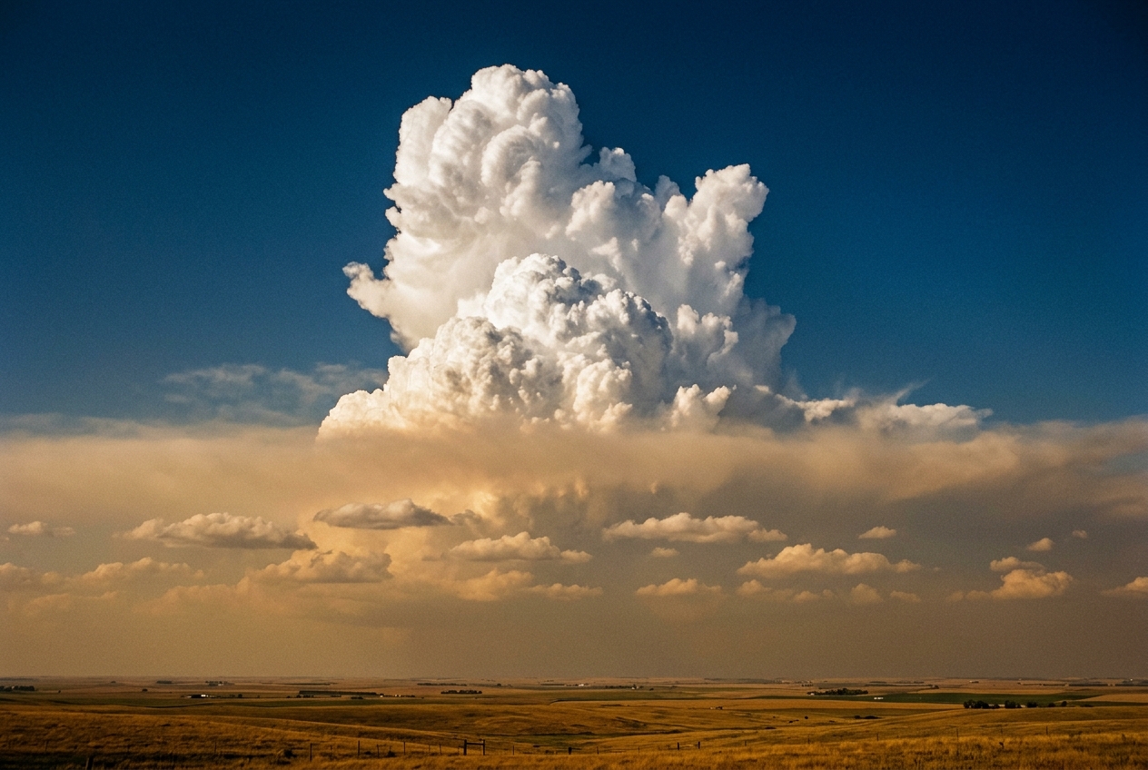
On a breathless midsummer afternoon across the interior plains, the earth radiates an oppressive, suffocating warmth. The grass is dry, rustling underfoot like parchment, yet the air itself feels nearly liquid—laden with water vapour transported from distant maritime basins. Overhead, small, innocuous cotton-puff clouds drift across the azure dome. But if you watch them closely, they do not billow into towering celestial mountains; instead, they flatten at their crowns, shearing out into frayed, horizontal discs before dissolving into dry air. They look trapped, arrested in their upward climb as though colliding with a polished sheet of plate glass.
 Altitude
    ^
    |          UNSTABLE TROPOSPHERE (Buoyant Ascent / Free Convection)
    |          ................................................... <-- LFC
    |          CAPPING INVERSION (Negative Buoyancy / CIN Layer)
    |          ~~~~~~~~~~~~~~~~~~~~~~~~~~~~~~~~~~~~~~~~~~~~~~~~~~~ <-- LCL (Cloud Base)
    |          WELL-MIXED BOUNDARY LAYER (Sensible Heating)
    +-------------------------------------------------------------> Temperature
The air pressure feels heavy and tactile against the skin, an electrostatic tension that precedes a break in the weather. The breeze dies completely. There is no thunder yet, no darkening of the western horizon, only a stillness punctuated by the drone of cicadas. This deceptive quietude is not an absence of atmospheric energy; it is an act of violent containment. Between the sun-baked soil and the deep, cold upper troposphere sits an invisible thermodynamic barricade. Meteorologists know this barrier as convective inhibition, and the threshold beyond which it shatters as the level of free convection. Understanding the physics of this boundary reveals one of nature’s most counterintuitive paradoxes: the fiercest, most destructive storms require a resilient atmospheric lid to prevent them from firing too soon.
What’s Actually Happening: The Thermodynamic Pressure Cooker
To understand why the sky suppresses its own storms, consider the atmosphere not as an empty void, but as a dense, stratified fluid. Much like a vast multi-layered cake, each horizontal tier of air possesses its own distinct temperature, moisture content, and density.
When solar radiation strikes the ground, it heats the immediate surface layer of air through conduction and turbulent mixing. Because warm air expands, it becomes less dense than the cooler air sitting directly above it. Like a submerged cork or a child’s helium balloon, this parcel of warm, moist air begins to ascend. As it rises, it enters regions of progressively lower atmospheric pressure, causing it to expand adiabatically. This expansion forces the parcel to do work on its surroundings, which cools it at the dry adiabatic lapse rate—precisely $9.8^\circ\text{C}$ for every kilometre of elevation.
Eventually, the rising parcel cools to its dew point. At this exact geometric height—known as the Lifting Condensation Level (LCL)—water vapour begins condensing into microscopic liquid droplets. To an observer on the ground, the LCL is unmistakable: it forms the razor-flat, grey-tinted underside of every cumulus cloud across the horizon.
       [ POSITIVE BUOYANCY: Runaway Deep Convection / CAPE ]
                             ^
                             |  <-- Level of Free Convection (LFC)
       =======================================================
       [ NEGATIVE BUOYANCY: Capping Inversion / CIN Barrier ]
       =======================================================
                             ^
                             |  <-- Lifting Condensation Level (LCL: Cloud Base)
       [ SUB-CLOUD LAYER: Dry Adiabatic Ascent (No Condensation) ]
                             ^
                       [ Earth's Surface ]
Condensation liberates latent heat—the hidden energy absorbed when liquid water originally evaporated—which slows the parcel's cooling rate to the moist adiabatic lapse rate (roughly $4^\circ\text{C}$ to $7^\circ\text{C}$ per kilometre). One might assume that this internal heat injection would immediately launch the cloud into the stratosphere.
In a pristine, undisturbed atmosphere, it often does. But on days primed for severe weather, a hostile layer of warm, dry air—often advected from elevated arid plateaus or subsidence zones—frequently overlies the moist boundary layer.
This warm layer is called a capping inversion, or simply "the cap." Because this capping layer is warmer than the rising, expanding cloud parcel, the cloud suddenly finds itself colder and denser than the ambient air surrounding it. Its buoyant ascent abruptly reverses; gravity pulls it downward, arresting its vertical momentum. The cloud spreads out laterally, frustrates itself against the cap, and evaporates.
Only if a parcel is forced upward with sufficient mechanical violence to penetrate this hostile ceiling will it reach the Level of Free Convection (LFC). The LFC is the exact thermodynamic altitude at which the ascending parcel once again becomes warmer and less dense than the ambient environment. Once past the LFC, the parcel no longer needs an external push; it accelerates skyward under its own buoyant power, converting thousands of Joules of stored thermal potential into explosive convective updrafts.
The Science: The Energetics of the Atmospheric Lid
To quantify the strength of this atmospheric barrier, meteorologists analyze the vertical profile of the atmosphere using thermodynamic soundings, typically plotted on a Skew-T Log-P Diagram. Two foundational thermodynamic parameters dictate the initiation and violence of deep moist convection: Convective Inhibition (CIN) and the Level of Free Convection (LFC).
Pressure (hPa)
  200 |                  / (Parcel Path)
      |                 /
  400 |      (CAPE)    /   Environment Temperature
      |               /   /
  600 |              /   /
      |    LFC ---> x   /
  700 |      (CIN) / \ /  <-- Capping Inversion (T_env > T_parcel)
  850 |   LCL ---> x   |
      |           /    /
 1000 |__________/____/____
                 Temperature (°C)
The Mathematical Formulation of Convective Inhibition
The vertical acceleration $a_z$ of an isolated air parcel governed by buoyant forces is derived from the balance of gravity and pressure gradients, expressed via Archimedes' principle:
$$a_z = \frac{d^2z}{dt^2} = g \left( \frac{\rho_{\text{env}} - \rho_{\text{parcel}}}{\rho_{\text{parcel}}} \right) \approx g \left( \frac{T_{v,\text{parcel}} - T_{v,\text{env}}}{T_{v,\text{env}}} \right)$$
where $g$ is the acceleration due to gravity ($9.81\text{ m/s}^2$) and $T_v$ is the virtual temperature in Kelvin. The virtual temperature represents the temperature that dry air must have to share the identical density and pressure of a moist parcel, rigorously adjusting for the lighter molecular weight of water vapour ($M_{H_2O} \approx 18.02\text{ g/mol}$) relative to dry air ($M_{\text{dry}} \approx 28.97\text{ g/mol}$):
$$T_v \approx T (1 + 0.61q)$$
where $q$ is the specific humidity in kilograms of water vapour per kilogram of moist air.
When an air parcel is lifted from the surface ($z_{\text{sfc}}$) through the boundary layer to its Level of Free Convection ($z_{\text{LFC}}$), it traverses a layer where $T_{v,\text{parcel}} < T_{v,\text{env}}$. Within this zone, the buoyancy force acts downward, resisting ascent.
Convective Inhibition (CIN) represents the total negative work per unit mass that must be performed on the parcel by external mechanical or thermodynamic forces to lift it through this negatively buoyant layer to the LFC:
$$\text{CIN} = \int_{z_{\text{sfc}}}^{z_{\text{LFC}}} g \left( \frac{T_{v,\text{parcel}}(z) - T_{v,\text{env}}(z)}{T_{v,\text{env}}(z)} \right) dz$$
In pressure coordinates ($p$), applying the hydrostatic equation ($dp = -\rho g dz = -\frac{p g}{R_d T_v} dz$), CIN is formulated as:
$$\text{CIN} = \int_{p_{\text{sfc}}}^{p_{\text{LFC}}} R_d \left( T_{v,\text{parcel}}(p) - T_{v,\text{env}}(p) \right) d\ln p$$
where $R_d = 287.058\text{ J}/(\text{kg}\cdot\text{K})$ is the specific gas constant for dry air. Because $T_{v,\text{parcel}} < T_{v,\text{env}}$ throughout this integration interval, the resulting integral yields a negative scalar, canonically expressed in Joules per kilogram ($\text{J/kg}$).
Atmospheric Energetics Reference
- Weak Cap ($|\text{CIN}| < 25\text{ J/kg}$): The barrier is fragile. Unfocused, widespread "popcorn" showers develop early, diffusing available boundary-layer energy.
- Moderate Cap ($25\text{ J/kg} \le |\text{CIN}| \le 100\text{ J/kg}$): The optimal capping regime for severe supercells. Prevents premature venting while allowing moisture and heat to accumulate until a mechanical trigger breaches the barrier.
- Strong Cap ($|\text{CIN}| > 200\text{ J/kg}$): Convective initiation is heavily suppressed. The atmospheric lid remains intact unless breached by extreme frontogenesis or mountain lift.
The Mechanical Trigger Requirement
If an air parcel receives no continuous external thermodynamic heating, it must possess sufficient initial vertical kinetic energy at the surface or boundary layer to overcome the negative work of CIN.
By applying the conservation of mechanical energy per unit mass, the kinetic energy expended during vertical deceleration against the negative buoyancy field must equal or exceed the magnitude of Convective Inhibition:
$$\frac{1}{2} w_{\text{min}}^2 \ge |\text{CIN}|$$
Solving directly for the minimum initial vertical velocity $w_{\text{min}}$:
$$w_{\text{min}} = \sqrt{2 \cdot |\text{CIN}|}$$
This simple, elegant equation reveals the exact physical threshold separating an unblemished sky from a violent storm initiation.
A Worked Real-World Calculation
Consider a warm spring day across the southern Great Plains, monitored closely by the NOAA Storm Prediction Center. A morning atmospheric sounding reveals an environment with an elevated mixed layer capping the boundary layer, producing a moderate convective inhibition value:
$$|\text{CIN}| = 50\text{ J/kg}$$
To compute the vertical velocity an air parcel requires to breach this barrier purely through kinetic momentum:
$$w_{\text{min}} = \sqrt{2 \cdot (50\text{ J/kg})} = \sqrt{100\text{ m}^2/\text{s}^2} = 10.0\text{ m/s}$$
A sustained upward velocity of $10\text{ m/s}$ ($36\text{ km/h}$ or $22.4\text{ mph}$) is extraordinarily large for standard boundary-layer thermals, which typically exhibit vertical speeds of merely $1\text{ to }3\text{ m/s}$.
This calculation demonstrates why pure thermal buoyancy from solar heating is often insufficient on capped days. To breach a $50\text{ J/kg}$ cap, the atmosphere requires concentrated mechanical forcing mechanisms: 1. Surface Cold Fronts: Dense, cold air undercutting moist air, forcing it rapidly upward along the frontal slope. 2. Drylines: Sharp density interfaces between dry desert air and moist maritime air, creating intense localized convergence zones. 3. Outflow Boundaries (Gust Fronts): Rain-cooled downdrafts from earlier storms acting as miniature mechanical wedges. 4. Orographic Lift: Mountain slopes physically deflecting horizontal surface winds into forceful vertical currents.
MECHANICAL TRIGGERING SCENARIOS:
-------------------------------------------------------------------------
(A) Cold Front / Dryline Wedge:    (B) Orographic Forcing:
       Moist Inflow --->                  Moist Inflow --->  / Mountain
          \       ^                          \       ^      /   Slope
           \     / Updraft (>10 m/s)          \     /      /
      ======\===/=============            =====\===/======/
       Dense Cold Air Wedge               Ground Level
-------------------------------------------------------------------------
The Capping Paradox in Severe Storm Dynamics
This mathematical relationship exposes the central paradox of severe storm meteorology: convective inhibition is both the enemy and the essential architect of supercell thunderstorms.
If an atmospheric profile contains zero CIN ($0\text{ J/kg}$), every thermal generated by morning sunshine immediately breaches the local LFC. The sky becomes cluttered with dozens of weak, disorganized showers and brief thunderstorms. These early storms cast cloud shadows over the earth, cut off surface insolation, and consume boundary-layer moisture before significant instability can accumulate.
Conversely, when a moderate cap of $25\text{ to }75\text{ J/kg}$ is present, it functions as an impermeable lid over a boiling pot. Beneath this lid, solar radiation continues to pour thermal energy into the planetary boundary layer for six to eight hours. Evapotranspiration pumps moisture into the low-level air, driving dew points into the mid-20s Celsius.
Because the energy cannot escape upward, the boundary layer accumulates enormous quantities of Convective Available Potential Energy (CAPE), frequently exceeding $3,000\text{ to }5,000\text{ J/kg}$.
When a dynamic trigger—such as an approaching shortwave trough documented by the UK Met Office or a sharpening dryline—finally provides the required $w_{\text{min}}$, the cap does not merely open; it ruptures. The trapped enthalpy is discharged not through hundreds of weak showers, but through a few discrete, highly organized supercell towers capable of producing giant hail, destructive straight-line winds, and violent tornadoes.
Field Observer Diagnostics: Reading the Sky and Instruments
For naturalists, mariners, mountaineers, and storm spotters, the unseen war between Convective Inhibition and rising buoyant parcels leaves distinct, readable signatures in both the sky and field instruments.
VISUAL FIELD SPECTRUM:
-------------------------------------------------------------------------
  [ Cumulus Humilis ]    -->    [ Cumulus Congestus ]    -->   [ Cumulonimbus ]
   Flattened tops;               Sharp, boiling towers;        Glaciated anvil;
   Trapped beneath Cap.          Breaching the LFC.            Explosive Release.
-------------------------------------------------------------------------
1. Visual Cloud Morphologies
- The Stifled Pancake (Cumulus humilis): In the presence of a strong cap, fair-weather cumulus clouds will have flat bases (the LCL) and equally flat, sheared-off tops. If you observe cumulus clouds that appear wider than they are tall, their upward momentum is being annihilated by a capping inversion. The lid is firmly in place.
- The "Boiling Cauliflower" (Cumulus congestus): When the surface temperature reaches its convective temperature—or when an approaching boundary provides mechanical lift—the tops of individual cumulus elements will cease flattening. Instead, their towers will exhibit hard, crisp, rapidly boiling edges that look like fresh cauliflower crowns expanding at several meters per second.
- The Rupture and Glaciation: When a congestus tower successfully pierces the LFC, its ascent rate visibly surges. Within minutes, its crisp, hard water-droplet edges soften into fibrous, feathery streaks of ice crystals (glaciation), forming a cirrus anvil. This visual transition confirms that the parcel has escaped the CIN barrier and is accelerating freely through the equilibrium level.
       Visual Signature of LFC Penetration:

                . - ~ ~ ~ - .      <-- Anvil Glaciation (Cirrus / Ice Crystals)
            . '               ' .
           (   CUMULONIMBUS      )
            . _               _ .
                ' - . _ . - '
                     / \
                    /   \          <-- Explosive Vertical Acceleration
                   /     \
             [=== CAPPING LID ===] <-- LFC Pierced Here
                 |       |
                 |  (C)  |         <-- Hard-Edged "Cauliflower" Tower
                 |_______|
                 |       |         <-- Flat Base at LCL
       ~~~~~~~~~~~~~~~~~~~~~~~~~~~
2. Instrumental Indicators
A discerning field observer equipped with standard atmospheric instruments can track the erosion of convective inhibition in real time:
- Barometric Tendency: A steady barometric decline followed by rapid micro-scale fluctuations often indicates the approach of a mesoscale boundary (such as a dryline or cold front) capable of supplying the critical $w_{\text{min}}$ velocity.
- The Dew Point Spike: A sudden increase in surface dew point during the afternoon, accompanied by backing surface winds (turning counter-clockwise, e.g., from southwesterly to southeasterly), indicates the advection of rich moisture beneath the cap. This depresses the LCL height and narrows the distance between the LCL and LFC, systematically reducing the integral magnitude of CIN.
- Sudden Thermal Drop: If the ambient air temperature abruptly drops by several degrees while winds gust and veer, a rain-cooled outflow boundary from distant convection has arrived. This boundary acts as a physical snowplow, lifting ambient warm air parcels through their local LFC.
| Observation Parameter | Capped / Suppressed Condition | Imminent Cap Rupture / Storm Firing |
|---|---|---|
| Cloud Base to Cloud Top Ratio | Width exceeds vertical depth; flat tops | Vertical depth rapidly exceeds width; crisp edges |
| Cloud Edge Definition | Frayed, hazy, dissipating quickly | Tense, boiling, razor-sharp cauliflower contours |
| Surface Dew Point Trend | Static or mixing out (falling) | Steadily rising or pooling along a convergence line |
| Surface Wind Field | Light, unorganized, or veered westerly | Backed southeasterly, breezy, converging locally |
| Barometer | Steady diurnal tidal curve | Rapidly falling pressure or sharp localized pressure jump |
Practical Guidance for the Outdoors
For the hiker in the mountains, the sailor along coastal waters, or the agricultural worker in open country, understanding the mechanics of CIN and the LFC is an indispensable safety skill:
- The Ridge-Line Rule for Hikers: Mountain ranges act as elevated heat sources and mechanical ramps. A capping inversion that suppresses storms over an adjacent valley may be easily breached over the peaks, where thermal elevation and orographic lift combine to eliminate CIN hours ahead of the lowlands. If cumulus crowns over high peaks begin boiling before noon, descend immediately.
- The Blue-Sky Trap for Sailors and Aviators: A clear, sunny sky in an area under a severe weather watch is not a sign that the forecast was incorrect; it is proof that the cap is functioning properly. The longer the sky stays clear beneath a strong capping lid, the more solar enthalpy is trapped in the boundary layer. When the breach occurs, the transition from blue sky to a severe squall line can occur in under thirty minutes.
- The 30-Minute Visual Clock: Once you identify an isolated cumulus tower whose edges remain crisp through the capping zone and transition into fibrous ice crystals aloft, you are witnessing an active LFC breach. Assume deep convective downdrafts, lightning, and severe straight-line winds will reach the surface within twenty to thirty minutes along the storm's track.
Today’s Meteorological Rule of Thumb
A clear, humid sky held down by a capping lid is an uncoiled spring: the longer the cap suppresses the clouds, the more violent the storm when the lid finally breaks.
When you step outside on a sweltering summer afternoon and see small, flattened clouds failing to climb into the blue, take note of that invisible ceiling. You are standing inside a global thermodynamic engine whose safety valve is clamped shut. Watch the horizon for the first tower that refuses to flatten—for in that single boiling plume lies the kinetic proof of an atmosphere that has breached its threshold, converting silent potential into the most awe-inspiring display of power on Earth.
Authoritative References and Further Reading
- Review thermodynamic skew-T analysis and convective metrics via the NOAA National Severe Storms Laboratory (NSSL).
- Study sounding parameters and severe weather forecasting techniques at the UK Met Office Atmospheric Science Section.
- Explore international observing standards and cloud classification systems through the World Meteorological Organization (WMO).
- Deepen your understanding of buoyant energy equations via the Convective Available Potential Energy Guide.
- Examine thermodynamic diagram mechanics through the Skew-T Log-P Atmospheric Analysis Primer.