Heat Dome Dynamics & Subsidence Warming: How Persistent Upper-Level Ridges and Adiabatic Compression Trap Stifling Continental Heat
1. Opening Scene: The Weight of an Unbroken Sky
Step outside at ten in the morning during the apex of a mid-latitude summer heatwave, and the first sensation is not merely the warmth, but an uncanny, paralyzing stillness. The wind has died completely, leaving the leaves of mature deciduous trees hanging limp and motionless like lead foil. The ambient air does not feel like a refreshing fluid through which one moves; rather, it possesses a tactile, suffocating density, pressing against the skin with the dry persistence of an open kiln.
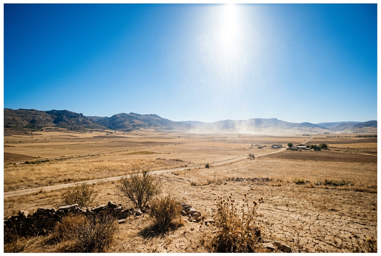
Look toward the horizon. The vibrant cerulean blue of a clear summer morning has been bleached into a milky, brassy haze. Fine particulate matter, photochemical ozone, and dry dust—unable to escape into the upper atmosphere—are trapped in a shallow, stagnant layer near the ground. Most striking of all is the total, eerie absence of clouds. Under normal summer conditions, the intense morning heating of the Earth’s surface triggers buoyant thermal updrafts: invisible bubbles of warm air that punch into the cooler sky above, condensing into cotton-ball fair-weather cumulus clouds by midday. Today, however, no such clouds materialize. Plumes of surface heat rise only to hit an invisible, impenetrable ceiling aloft, flattening out and vanishing into the glaring sky.
By mid-afternoon, the ground radiates heat with ferocious intensity. Pavements bake at temperatures exceeding sixty degrees Celsius; the air hovering an inch above the asphalt shimmers in dizzying optical mirages; birds seek refuge deep within dense, shaded shrubs, panting with open beaks to shed thermal load. Even as the sun dips below the horizon, the anticipated evening relief fails to arrive. The suffocating warmth lingers through midnight and into the pre-dawn hours, radiating back from the parched soil and asphalt. You are standing inside a meteorological pressure cooker—a planetary heat dome.
2. What Is Actually Happening: The Sky’s Giant Plunger
To understand why a heat dome is so intensely hot and persistent, it helps to strip away the complex mathematical machinery of fluid dynamics and look at the atmosphere through everyday mechanical analogies.
Think of the troposphere—the lowest ten to twelve kilometres of our atmosphere where all weather occurs—as a giant, layered fluid. In normal weather patterns, the mid-latitude jet stream acts like a swift atmospheric river flowing from west to east, steering high- and low-pressure weather systems across continents in a steady, rolling procession. Storms arrive, bring rain and wind, vent accumulated surface heat toward the upper atmosphere, and move along, allowing cooler air masses to sweep in behind them.
Occasionally, however, this planetary river slows down and begins to meander violently, forming massive loops that snake north and south across thousands of kilometres. When one of these northern loops grows exceptionally large, it can detach or stall entirely, freezing in place for one to three weeks. Meteorologists call this an atmospheric blocking pattern.
Underneath this stalled atmospheric ridge sits a colossal mountain of high-pressure air. Because air naturally flows outward from regions of high pressure near the surface, the atmosphere must draw air down from the high, cold reaches of the upper troposphere to replace it. This vast, downward-sinking motion of air is known as subsidence.
Now imagine pumping up a bicycle tyre with a manual hand pump. If you pump vigorously for a minute and then touch the base of the metal pump cylinder, it feels burning hot. Why? You did not apply an external flame to the pump; rather, by forcing a volume of air into a smaller space, you compressed its molecules together, converting the mechanical work of compression directly into thermal kinetic energy.
The exact same physics governs a heat dome. As massive volumes of air sink through the atmosphere over several days, they descend from the thin, low-pressure environment of the upper troposphere into the dense, high-pressure environment near the Earth's surface. As ambient atmospheric pressure rises around the descending air, the air is continuously compressed. And as it is compressed, it warms up automatically—at a rate of nearly ten degrees Celsius for every single kilometre it sinks.
This descending, self-heating blanket of air acts like a heavy, transparent lid clamped over a simmering pot. It creates a warm layer aloft—a subsidence inversion—that completely caps the lower atmosphere. Surface heat cannot rise past this lid to form cooling rainstorms, winds are suppressed into stillness, and day after day of uninterrupted, high-angle solar radiation bakes the ground below, driving surface temperatures to historic extremes.
3. The Science: Synoptic Dynamics, Thermodynamics, and Energy Fluxes
For those who wish to examine the precise physics driving these extreme events, the creation of a heat dome is an elegant demonstration of synoptic-scale dynamic meteorology and classical thermodynamics working in concert.
Synoptic Architecture: Rossby Waves and Planetary Blocks
Heat domes are fundamentally anchored by high-amplitude planetary-scale Rossby waves. When the jet stream exhibits strong meridional (north-south) undulations, the flow can organize into persistent configurations such as an Omega Block (named for its resemblance to the Greek letter $\Omega$) or a Rex Block (where a high-pressure anticyclone sits directly poleward of a low-pressure cyclone).
Within the core of a warm-core anticyclone, quasi-geostrophic theory dictates that upper-tropospheric convergence and negative vorticity advection drive large-scale vertical subsidence throughout the depth of the column:
$$w < 0 \quad \left(\text{or in pressure coordinates, } \omega = \frac{dp}{dt} > 0\right)$$
This downward motion typically spans from the upper troposphere (around 300 to 200 hPa) all the way down to the top of the planetary boundary layer (around 850 to 700 hPa).
Thermodynamic Law 1: Dry Adiabatic Compressional Warming
As an unsaturated parcel of mid-tropospheric air descends under the influence of large-scale subsidence, it undergoes an adiabatic process—meaning it exchanges virtually no heat with the surrounding environment via conduction or radiation on dynamic timescales. Its potential temperature ($\theta$) is conserved:
$$\theta = T \left( \frac{p_0}{p} \right)^{R_d / c_p} = \text{constant}$$
where $T$ is absolute temperature in Kelvin, $p$ is ambient pressure, $p_0$ is the standard reference pressure ($1000\text{ hPa}$), $R_d \approx 287.05\text{ J}\cdot\text{kg}^{-1}\cdot\text{K}^{-1}$ is the specific gas constant for dry air, and $c_p \approx 1005\text{ J}\cdot\text{kg}^{-1}\cdot\text{K}^{-1}$ is the specific heat capacity at constant pressure ($R_d / c_p \approx 0.286$).
Differentiating this relationship with respect to geometric height ($z$) under hydrostatic equilibrium ($\partial p / \partial z = -\rho g$) yields the fundamental constant of dry atmospheric thermodynamics—the Dry Adiabatic Lapse Rate ($\Gamma_d$):
$$\Gamma_d = -\frac{dT}{dz} = \frac{g}{c_p} \approx \frac{9.80665\text{ m/s}^2}{1005\text{ J/(kg}\cdot\text{K)}} \approx 9.8\text{ K/km} \quad (\approx 9.8^\circ\text{C per 1,000 metres})$$
What this equation predicts:
For every 1,000 metres that an unsaturated air parcel is forced downward by large-scale anticyclonic subsidence, its temperature increases by approximately $9.8^\circ\text{C}$ solely due to mechanical compression against rising ambient atmospheric pressure.
Worked Thermodynamic Proof:
Consider an air parcel situated in the mid-troposphere at the 500 hPa geopotential height level (roughly $5,500\text{ metres}$ above sea level), where its initial temperature is a freezing $-10.0^\circ\text{C}$ ($263.15\text{ K}$). Over the course of 72 hours, synoptic subsidence forces this parcel downward to the top of the convective boundary layer at 850 hPa (roughly $1,500\text{ metres}$ above sea level).
-
Calculate the vertical displacement ($\Delta z$): $$\Delta z = z_{\text{initial}} - z_{\text{final}} = 5,500\text{ m} - 1,500\text{ m} = 4,000\text{ m} = 4.0\text{ km}$$
-
Calculate the compressional temperature rise ($\Delta T$): $$\Delta T = \Gamma_d \times \Delta z = 9.8\text{ K/km} \times 4.0\text{ km} = +39.2\text{ K} \quad (+39.2^\circ\text{C})$$
-
Calculate the resulting temperature at 850 hPa ($T_{\text{final}}$): $$T_{\text{final}} = T_{\text{initial}} + \Delta T = -10.0^\circ\text{C} + 39.2^\circ\text{C} = +29.2^\circ\text{C} \quad (302.35\text{ K})$$
An air mass that originated well below freezing in the upper atmosphere arrives at the top of the boundary layer as a blistering $29.2^\circ\text{C}$ thermal cap. When this superheated air is subsequently mixed down to the surface by strong diurnal turbulence, it pushes surface ambient temperatures well past $40^\circ\text{C}$ to $45^\circ\text{C}$.
The Subsidence Inversion: Capping the Planetary Boundary Layer
In a standard atmosphere, temperature decreases with height. However, deep subsidence creates an anomalous thermodynamic structure. Sinking air warms at the dry adiabatic rate ($9.8\text{ K/km}$), while the air in the immediate contact layer at the surface is governed by local boundary layer processes.
Where the descending, adiabatically warmed air meets the rising convective boundary layer (typically between 850 hPa and 700 hPa), it forms a sharp subsidence inversion—a vertical zone where temperature actually increases with height ($\partial T / \partial z > 0$).
This inversion acts as a dynamic hydraulic seal with three major consequences: 1. Convective Inhibition (CIN): It imposes a massive energetic barrier that convective thermals cannot breach. Even with surface temperatures exceeding $40^\circ\text{C}$, air parcels cannot reach their Level of Free Convection (LFC). Deep convective venting—the atmosphere's primary method for shedding excess equatorial and summer heat via thunderstorms—is entirely shut down. 2. Moisture and Pollutant Entrainment: Surface emissions (volatile organic compounds, nitrogen oxides, ozone precursors, and particulate matter) are strictly confined within a shallow atmospheric volume, deteriorating air quality. 3. Diurnal Heat Accumulation: Because the thermal reservoir cannot vent upward or advect horizontally (due to near-zero synoptic pressure gradients at the centre of the anticyclone), solar energy accumulates cumulatively day after day.
Thermodynamic Law 2: Land-Atmosphere Feedback and the Bowen Ratio
The final piece of the heat dome puzzle lies at the interface between the atmosphere and the Earth's surface. The surface energy balance equation dictates how net incoming solar radiation is partitioned:
$$R_n - G = Q_H + Q_E$$
where $R_n$ is net all-wave radiation, $G$ is ground soil heat flux, $Q_H$ is sensible heat flux (thermal energy that directly increases air temperature), and $Q_E$ is latent heat flux (energy consumed by evaporating water and plant transpiration).
The partition between sensible and latent heat is quantified by the Bowen Ratio ($B$), formulated by American physicist Ira Sprague Bowen:
$$B = \frac{Q_H}{Q_E}$$
What this equation predicts:
The Bowen ratio measures whether the sun’s energy is primarily spent heating the air ($Q_H$) or evaporating water ($Q_E$). When soil moisture is abundant, $Q_E$ is large, $B$ is low ($0.1$ to $0.4$), and the landscape cools itself through evapotranspiration—much like human skin shedding heat via perspiration. When soils desiccate completely, $Q_E$ collapses to zero, forcing $B$ to skyrocket ($> 3.0$). In this regime, virtually $100\%$ of incoming solar energy is converted directly into sensible heat, causing surface temperatures to explode.
| Environmental Surface Condition | Typical Bowen Ratio ($B$) | Fate of Solar Energy | Surface Air Temperature Impact |
|---|---|---|---|
| Lush Vegetation / Wet Soil | $0.10 - 0.30$ | $>80\%$ Latent Heating ($Q_E$) | Strongly buffered; modest daily peaks |
| Typical Agricultural Land | $0.40 - 0.80$ | Balanced Partitioning | Normal seasonal summer warmth |
| Drought-Stricken Soils | $2.00 - 5.00$ | $>70\%$ Sensible Heating ($Q_H$) | Rapid, intense daily temperature rise |
| Hyper-Arid Desert / Heat Dome Core | $5.00 - 15.00+$ | $>95\%$ Sensible Heating ($Q_H$) | Extreme, record-shattering hyperthermia |
Worked Surface Energy Calculation:
Suppose a mid-latitude region under a clear midsummer sky receives a midday net radiative flux of $R_n - G = 600\text{ W/m}^2$.
Case A: Moist Soil Environment ($B = 0.20$) $$Q_H = (R_n - G) \times \frac{B}{1 + B} = 600 \times \frac{0.20}{1.20} = 100\text{ W/m}^2$$ $$Q_E = (R_n - G) \times \frac{1}{1 + B} = 600 \times \frac{1.00}{1.20} = 500\text{ W/m}^2$$ Here, $500\text{ W/m}^2$ of energy is safely locked away as latent heat without raising the temperature of the air by a single degree.
Case B: Severe Drought Priming under a Heat Dome ($B = 5.0$) $$Q_H = 600 \times \frac{5.0}{1 + 5.0} = 600 \times \frac{5.0}{6.0} = 500\text{ W/m}^2$$ $$Q_E = 600 \times \frac{1.0}{6.0} = 100\text{ W/m}^2$$
In Case B, sensible heat flux increases by $400\%$ ($500\text{ W/m}^2$ versus $100\text{ W/m}^2$). This massive surge in sensible heating rapidly deepens the superheated boundary layer, reinforcing a vicious positive feedback loop: subsidence dries the soil, dry soil superheats the boundary layer, and the superheated boundary layer expands the geopotential height of the ridge aloft, locking the heat dome in place.
4. Case Study: The Historic Pacific Northwest Super-Dome of June 2021
In late June 2021, the Pacific Northwest region of the United States and western Canada experienced what is widely considered one of the most statistically anomalous meteorological events in recorded human history. All-time temperature records across Oregon, Washington, and British Columbia were not merely broken—they were obliterated by margins of $4^\circ\text{C}$ to $6^\circ\text{C}$.
The day after setting the Canadian national record of $49.6^\circ\text{C}$, the village of Lytton was largely destroyed by a catastrophic wildfire ignited in the hyper-desiccated environment.
According to post-event analyses published by the National Oceanic and Atmospheric Administration and research documented in the American Meteorological Society journals, this event was driven by the convergence of three dynamic factors:
- A Historic Omega Block: A profound distortion in the polar jet stream generated a closed anticyclonic vortex over British Columbia and Washington with 500 hPa geopotential heights exceeding $5,980\text{ geopotential metres}$—a magnitude more than five standard deviations ($>5\sigma$) above the climatological mean for June.
- Extreme Adiabatic Subsidence and Föhn Downslope Enhancement: Relentless subsidence through the middle and lower troposphere drove adiabatic compressional heating across the Columbia River Basin. As this already superheated air drifted westward across the Cascade Mountains, it was forced down the western mountain slopes toward Puget Sound and the Willamette Valley, undergoing additional downslope compressional warming (the Föhn effect).
- Severe Antecedent Soil Drought: Spring 2021 had been among the driest on record across the Pacific Northwest. Soil moisture reserves were virtually depleted before the ridge arrived, driving the Bowen ratio to desert-like levels ($B > 4.0$). Evaporative cooling was nonexistent; every watt of solar radiation was translated directly into sensible heat.
Similar thermodynamic dynamics have driven severe European heatwaves analysed by the UK Met Office and highlighted by the World Meteorological Organization, where persistent summer blocking over the Mediterranean basin creates prolonged periods of extreme thermal stress.
5. Practical Outdoor Guidance: How to Diagnose a Heat Dome
While synoptic meteorologists rely on supercomputer simulations from forecasting centres like the European Centre for Medium-Range Weather Forecasts (ECMWF) and the US National Weather Service, an observant outdoor naturalist, hiker, gardener, or sailor can identify the development and intensification of a heat dome using basic instruments and sensory cues.
What to Look for in the Sky
- The "Bleached Horizon" and Inversion Layer: Notice the vertical transition in sky colour. High overhead, the sky may appear a deep, dry blue, but toward the horizon it turns milky white or yellow-grey. This marks the top of the planetary boundary layer, where the subsidence inversion is trapping aerosols and photochemical smog.
- Absence of Convective Cumulus: When surface temperatures reach $35^\circ\text{C}$ or $40^\circ\text{C}$ on a humid day without a cap, towering cumulus and thunderstorms develop rapidly. Under a heat dome, the sky remains utterly cloudless despite the extreme surface heat—a clear visual signature that a strong subsidence inversion is capping vertical motion.
- Aircraft Contrail Evaporation: Watch high-altitude commercial jet contrails. Under a subsiding, high-pressure ridge, the upper troposphere is exceptionally dry. Jet contrails will not linger or expand into cirrus sheets; they will evaporate within seconds of leaving the engine nozzles.
Instrument Readings to Monitor
- The Barometer: A heat dome is accompanied by sustained high surface pressure ($1018\text{ hPa}$ to $1030\text{ hPa}$), showing very little diurnal pressure fluctuation other than the subtle, twice-daily atmospheric thermal tides (peaking around 10:00 AM and 10:00 PM local time). If your barometer remains high while temperatures soar, you are in the core of an anticyclone.
- The Hygrometer (Relative Humidity vs. Dew Point): As afternoon temperatures peak, watch your relative humidity (RH). Under a strong subsidence regime, dry air from aloft is entrained downward into the boundary layer. RH values will plummet to desert levels (often below $15\%$), even in coastal or river-valley climates. However, pay close attention to the dew point temperature ($T_d$): if the dew point remains elevated while ambient temperature ($T$) spikes, human evaporative cooling via perspiration fails, dramatically raising the wet-bulb temperature and human health risk.
- Wind Direction and Speed: Look for prolonged calm periods ($0 - 5\text{ knots}$) during the morning and early afternoon, followed by erratic, localized thermal breezes driven strictly by microscale terrain heating rather than broad synoptic winds.
Practical Rules for Hikers, Gardeners, and Outdoor Workers
- The Nocturnal Recovery Metric: Measure the minimum overnight temperature. If the temperature at dawn remains above $22^\circ\text{C}$ to $25^\circ\text{C}$, the boundary layer has failed to decouple from the warm air aloft. This is a critical indicator of severe cumulative heat stress for plants, animals, and humans.
- Soil Desiccation Velocity: In a high Bowen ratio regime, the top three inches of garden or agricultural soil will lose moisture at triple the normal rate due to high vapor pressure deficits (VPD). Mulching must be applied before the heat dome establishes, as post-arrival watering will rapidly evaporate directly into the dry boundary layer.
- The High-Altitude Trap for Hikers: In standard atmospheric conditions, climbing a mountain provides cool relief (cooling at approximately $6.5^\circ\text{C}$ per kilometre of elevation gain). Under an intense heat dome with a strong subsidence inversion, mountain ridges between 1,000 and 2,500 metres can be significantly warmer than low-lying valleys during the night and early morning, leaving hikers exposed to continuous heat with no thermal refuge.
6. Today’s Meteorological Rule of Thumb
Summary Checklist of Heat Dome Mechanics
- Upper-Air Driver: High-amplitude Rossby wave forming a stalled Omega or Rex block.
- Dynamic Action: Tropospheric subsidence ($w < 0$) compressing and heating air dry-adiabatically ($\Gamma_d \approx 9.8\text{ K/km}$).
- Thermodynamic Seal: Strong subsidence inversion capping the boundary layer, preventing convective venting.
- Surface Amplification: Soil moisture depletion driving the Bowen ratio ($B = Q_H / Q_E$) upwards, converting nearly all solar radiation directly into sensible heat.