Green Sky Optics & Severe Storm Scattering: How Hydrometeor Loading and Red-Shifted Twilight Forge Viridescent Pre-Tornadic Skies
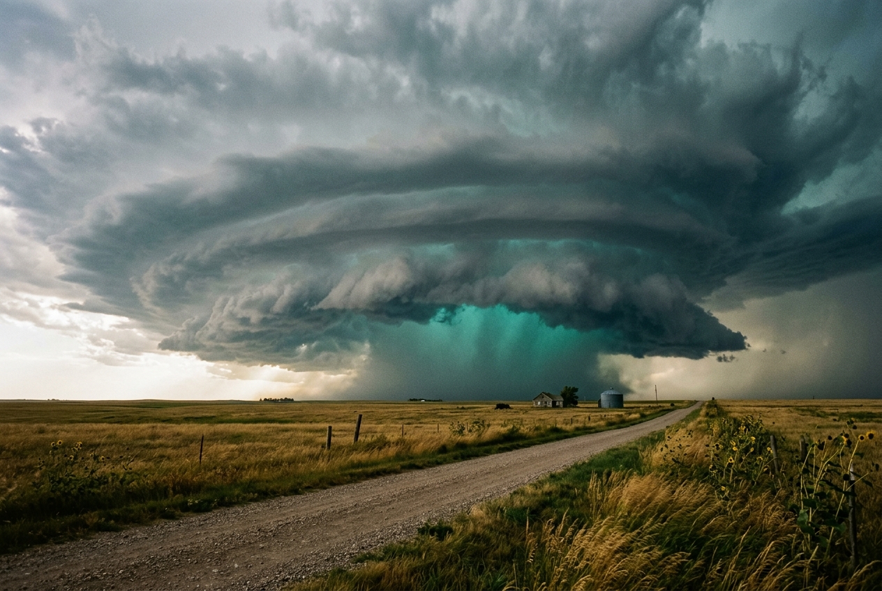
1. Opening Scene: The Atmosphere Turns Vitreous
The air in the midsummer late afternoon ceases to circulate, heavy with a suffocating, gelatinous humidity. On the southern Great Plains, the ambient temperature has hovered near 36°C for hours, baking the topsoil until the earth smells faintly of scorched clay and desiccated grass. Then, imperceptibly at first, the pressure drops. The skin senses it before the ears pop—an unsettling atmospheric decompression as an unseen mesoscale updraft miles away begins evacuating millions of metric tons of tropospheric air every second.
To the west, the horizon has long ceased to be blue. A towering cumulonimbus incus has breached the tropopause, its overshooting top punching violently into the lower stratosphere like a frozen volcanic plume. Beneath the massive, bruised expanse of its forward-flank anvil, the familiar quality of terrestrial daylight begins to distort. The wind dies completely into an eerie, dead calm. A sudden, sharp descent of temperature follows—a drop of ten degrees in under three minutes—carrying the metallic tang of ionized ozone and the intoxicating, earthy petrichor of distant rain striking hot dust.
                                  [ SUNLIGHT: Low Zenith Angle ]
                                                \  (Direct & Rayleigh-Reddened)
                                                 \
      ============================================\================ Tropopause
     /                                             \
    /     CUMULONIMBUS CONVECTIVE CORE              v
   |   (Extreme LWC > 3.0 g/m³ & Hail Cascade)   [ CLOUD TOP ]
   |                                                   |
   |   [ WATER / ICE MULTIPLE SCATTERING ]             |
   |   • Red / Near-IR Wavelengths Absorbed (λ > 600nm)| Photons undergo
   |   • Green Wavelengths Transmitted (λ ~ 520nm)     | tortuous paths
   |                                                   v
   \                                             [ CLOUD BASE ]
    \____ [ SHELF CLOUD / RAIN VAULT ]                 |
         \____________________________________         v
                                              \   [ OBSERVER ]
                                                   (Sees Viridescent /
                                                    Emerald Sky)
Then the light mutates. It does not simply darken into the familiar charcoal or slate grey of a standard summer shower. Instead, a diffuse, alien luminescence settles over the landscape. Fields of amber wheat and asphalt roadways are bathed in a vivid, uncanny jade. Looking upward into the underbelly of the cloud base—near the turbulent shearing edge of the shelf cloud and the rain-free vault—the sky glows with the luminous, spectral hue of sea-green malachite and aged copper. The light is cast evenly across every surface, stripping away terrestrial warmth and replacing it with an icy, undersea radiance. To the human eye, it feels instinctively apocalyptic: nature signaling that the thermodynamic engine overhead has achieved extreme, catastrophic maturity.
2. What is Actually Happening: The Dual-Filter Mechanism
For over a century, folklore and storm chasers alike attributed this viridescent spectacle to mythology: that the green hue was caused by sunlight reflecting off vast carpets of green prairie grass, that it was light scattered through suspended algae lofted into the clouds, or, most notoriously, that it was an optical signature produced exclusively by tornadic vortices. Physical atmospheric optics and field experiments documented by the American Meteorological Society have conclusively dismantled these notions. The green thunderstorm sky is neither a reflection nor a tornado siren; it is the visual result of a natural, giant optical bandpass filter created by deep convective clouds.
To grasp how a cloud turns green, it is helpful to conceptualize the atmosphere as a two-stage optical laboratory operating during the late afternoon.
The First Filter: The Atmospheric Sunset Engine
Sunlight entering Earth’s upper atmosphere is inherently broad-spectrum "white" light, containing an equitable balance of all visible wavelengths from violet (380 nm) through red (750 nm). When the sun sits high overhead at noon, sunlight traverses a relatively thin slice of atmosphere, reaching our eyes essentially unaltered.
However, severe thunderstorms thrive on the intense thermodynamic heating of late afternoon and early evening, precisely when the sun sits at a low solar zenith angle. At this oblique angle, solar photons must travel through an atmospheric path length up to ten times longer than at midday. As light navigates this dense air mass, the tiny nitrogen and oxygen molecules selectively scatter the shorter blue and violet wavelengths out of the direct beam—a mechanism known as Rayleigh scattering. Consequently, the direct sunlight that strikes the upper flanks and western face of an oncoming evening supercell is heavily biased toward the long-wavelength end of the spectrum: deep oranges, ambers, and fiery reds.
The Second Filter: The Colossal Cloud Reservoir
Now, imagine what happens when this reddened evening sunlight penetrates the interior of an enormous cumulonimbus cloud. In everyday life, we think of water as completely transparent and colorless. In small volumes—such as a glass of water—it appears perfectly clear. But liquid water is intrinsically blue-green. Liquid water molecules absorb red and near-infrared light through molecular vibration.
A severe thunderstorm core is not a modest puff of vapor; it is a suspended lake held aloft by violent updrafts exceeding 150 kilometers per hour. Within this storm core, the Liquid Water Content (LWC) frequently surpasses 3 to 5 grams of liquid water per cubic meter of air, suspended across a vertical column extending 12 to 18 kilometers into the sky, accompanied by trillions of densely packed, wet hailstones.
When the orange-red twilight hits this monolithic column of water, the cloud droplets and hailstones act as an aggressive optical sponge. Photons bounce millions of times between droplets (multiple scattering), dramatically lengthening their journey through the water. With every millimeter traveled through this aquatic labyrinth, the water molecules absorb the red light.
The dual-filter mechanism is thus complete: 1. The open atmosphere has already stripped out the blue and violet light via Rayleigh scattering. 2. The dense cloud water strips out the red and orange light via molecular vibrational absorption.
With the blue end and the red end of the visible spectrum systematically removed by these two distinct physical processes, what remains in the middle of the spectrum to emerge from the cloud base? Green.
3. The Science: Radiative Transfer, Molecular Absorption, and Colorimetry
To quantify the emerald sky, we turn to the definitive optical framework established by Craig Bohren and Frank Gallagher. The spectral radiance exiting the base of a severe convective storm is governed by the principles of radiative transfer through an optically thick, multiple-scattering, absorbing medium.
Molecular Vibrational Absorption of Liquid Water
The red-absorption property of liquid water ($H_2O$) does not arise from electronic transitions (which occur predominantly in the ultraviolet), but from the higher harmonic overtones of fundamental molecular vibrational modes. The asymmetric stretch ($\nu_3$), symmetric stretch ($\nu_1$), and bending ($\nu_2$) modes of the bent $H_2O$ molecule combine to create substantial absorption bands in the near-infrared spectrum, with significant overtone "tails" bleeding directly into the visible red spectrum between 600 nm and 750 nm.
The intrinsic absorption coefficient of pure bulk water, $\alpha_{\text{abs}}(\lambda)$, varies dramatically across the visible spectrum: - At $\lambda = 450\text{ nm}$ (Blue): $\alpha_{\text{abs}} \approx 0.00015\text{ cm}^{-1}$ ($0.015\text{ m}^{-1}$) - At $\lambda = 520\text{ nm}$ (Green): $\alpha_{\text{abs}} \approx 0.00040\text{ cm}^{-1}$ ($0.040\text{ m}^{-1}$) - At $\lambda = 650\text{ nm}$ (Red): $\alpha_{\text{abs}} \approx 0.00350\text{ cm}^{-1}$ ($0.350\text{ m}^{-1}$)
Liquid water absorbs red light at 650 nm nearly nine times more strongly than it absorbs green light at 520 nm, and more than twenty times more strongly than blue light.
Equation 1: The Beer-Lambert Law of Spectral Attenuation
The monochromatic transmission $T(\lambda)$ of a direct light beam traversing an effective optical path length $L_{\text{eff}}$ through an absorbing water medium is modeled by the Beer-Lambert law:
$$T(\lambda) = \frac{E(\lambda)}{E_0(\lambda)} = \exp\left( -\alpha_{\text{abs}}(\lambda) \cdot L_{\text{eff}} \right)$$
Where: * $E_0(\lambda)$ is the incident spectral irradiance striking the cloud medium ($\text{W}\cdot\text{m}^{-2}\cdot\text{nm}^{-1}$). * $E(\lambda)$ is the transmitted spectral irradiance exiting the base. * $\alpha_{\text{abs}}(\lambda)$ is the linear absorption coefficient of the water content ($\text{m}^{-1}$). * $L_{\text{eff}}$ is the effective cumulative absorption path length (meters of equivalent bulk liquid water traversed by photons during diffuse multiple scattering).
Because a dense cumulonimbus cloud has an enormous scattering optical depth ($\tau \gg 100$), photons do not travel in straight lines; they diffuse through billions of Mie-scattering events with cloud droplets and hail. This increases the photon’s cumulative dwell time inside the water droplets, producing an effective path length through bulk water ($L_{\text{eff}}$) that is orders of magnitude greater than the physical thickness of the water if it were condensed into a single sheet.
Worked Example: Spectral Transformation in a Severe Core
Consider a severe supercell storm intercepted at 18:30 local time. The setting sun has reached a solar zenith angle $\theta_0 = 82^\circ$. Due to Rayleigh scattering along the prolonged atmospheric slant path, the incident twilight irradiance $E_0(\lambda)$ striking the cloud top and rear flank is heavily reddened, exhibiting a spectral ratio of:
$$\frac{E_0(650\text{ nm})}{E_0(520\text{ nm})} = 4.0$$
(The incident light possesses four times more red intensity than green intensity).
Now, let this twilight beam enter the massive forward-flank downdraft (FFD) core containing extreme liquid water content and wet hail, resulting in an effective bulk water absorption path length of $L_{\text{eff}} = 22.0\text{ meters}$.
Step 1: Calculate transmission for green light ($\lambda = 520\text{ nm}$): $$\alpha_{\text{abs}}(520\text{ nm}) = 0.040\text{ m}^{-1}$$ $$T(520\text{ nm}) = \exp(-0.040\text{ m}^{-1} \times 22.0\text{ m}) = \exp(-0.88) \approx 0.4148$$
Step 2: Calculate transmission for red light ($\lambda = 650\text{ nm}$): $$\alpha_{\text{abs}}(650\text{ nm}) = 0.350\text{ m}^{-1}$$ $$T(650\text{ nm}) = \exp(-0.350\text{ m}^{-1} \times 22.0\text{ m}) = \exp(-7.70) \approx 0.0004528$$
Step 3: Calculate the resulting transmitted spectral irradiance ratio: $$\frac{E(520\text{ nm})}{E(650\text{ nm})} = \left( \frac{E_0(520\text{ nm})}{E_0(650\text{ nm})} \right) \times \left( \frac{T(520\text{ nm})}{T(650\text{ nm})} \right)$$ $$\frac{E(520\text{ nm})}{E(650\text{ nm})} = \left( \frac{1}{4.0} \right) \times \left( \frac{0.4148}{0.0004528} \right) = 0.25 \times 916.08 = 229.02$$
Conclusion from Proof: While the sunlight entered the cloud with red light outnumbering green light 4 to 1, it emerges from the storm base with green light outnumbering red light by more than 229 to 1. The red light has been virtually annihilated by molecular absorption, transforming the transmitted illumination into a pronounced, narrow spectral peak centered between 500 nm and 540 nm.
Chromaticity and the CIE 1931 Color Space
To determine the precise color perceived by an observer on the ground, the exiting spectral irradiance $E(\lambda)$ must be integrated against the human eye's standard trichromatic cone response functions $\bar{x}(\lambda)$, $\bar{y}(\lambda)$, and $\bar{z}(\lambda)$ defined by the International Commission on Illumination (CIE 1931 color space):
$$X = \int_{380}^{780} E(\lambda)\bar{x}(\lambda)\,d\lambda, \quad Y = \int_{380}^{780} E(\lambda)\bar{y}(\lambda)\,d\lambda, \quad Z = \int_{380}^{780} E(\lambda)\bar{z}(\lambda)\,d\lambda$$
The chromaticity coordinates $(x, y)$ are computed via:
$$x = \frac{X}{X + Y + Z}, \quad y = \frac{Y}{X + Y + Z}$$
                CIE 1931 CHROMATICITY DIAGRAM (CONCEPTUAL)
        y ^
          |                 520 nm (Pure Spectral Green)
      0.8 +                   /\
          |                  /  \
      0.6 +                 /    \  <-- Severe Storm Sky Domain
          |                /   *  \     (x ≈ 0.26, y ≈ 0.48)
      0.4 +               /   D65  \
          |              /     o    \
      0.2 +             /            \
          |            /              \
      0.0 +---'-------'-------'-------'------->
          0.0        0.2     0.4     0.6      x
                     (Blue)          (Red)
In ordinary overcast conditions, light scattering is non-selective with respect to wavelength (optical depth is dominated by droplet size parameters where $2\pi r/\lambda \gg 1$), placing the chromaticity coordinates near the neutral daylight illuminant $D_{65}$ at $(x=0.3127, y=0.3290)$—a neutral slate-grey.
Under an extreme convective core, however, the collapse of spectral energy above 600 nm shifts the integrated tristimulus values dramatically toward the upper-left boundary of the chromaticity locus, reaching coordinates around $(x \approx 0.26, y \approx 0.48)$. This shifts the perceived color from neutral grey-blue into an intense, unsaturated turquoise-green.
Debunking the Tornado Myth vs. Severe Hail Realities
A persistent piece of North American folklore claims that a green sky is a direct, infallible precursor to an active tornado. According to extensive storm-intercept research by the NOAA National Severe Storms Laboratory (NSSL), this connection is a correlation rather than a causation.
| Optical / Meteorological Parameter | Tornadic Circulation | Severe Hail / High LWC Core |
|---|---|---|
| Physical Prerequisite | Intense vertical vorticity & low-level convergence | Immense liquid water mass ($>3\text{ g/m}^3$) & suspended hail |
| Optical Role | None (air vortex is optically transparent) | Direct optical bandpass absorption medium |
| Occurrence Without Green Sky | Common (e.g., nocturnal, low-precipitation supercells) | Rare (provided low solar angle aligns) |
| Direct Hazard Indicated | Wind shear, tornadoes | Damaging hail ($\ge 5\text{ cm}$), severe wet microbursts |
Green skies require three precise conditions: 1. An exceptionally deep convective column with massive Liquid Water Content (LWC) and hail volume. 2. A very high optical thickness that forces extensive photon multiple scattering. 3. An illuminating source dominated by low-zenith, Rayleigh-scattered golden/red sunlight (late afternoon/early evening).
Because supercell thunderstorms with violent, moisture-rich updrafts are the primary engines capable of suspending millions of tons of water and hail aloft, they frequently generate green skies and tornadoes simultaneously. However, the green sky is an optical diagnostic of hydrometeor density, updraft strength, and severe hail, not cyclonic rotation.
4. Practical Outdoor Guidance: Reading the Sky and Instruments
When an observer notices the ambient daylight taking on a viridescent cast, the atmosphere is warning of immediate, severe microphysical activity directly overhead or upwind.
1. Visual Sky Analysis
- The Hail Vault Contrast: Look toward the edge of the convective core where the darkest rain curtain meets the rain-free updraft base. If the rain curtain appears milky-white or glowing turquoise rather than uniform black or dark blue, you are looking at large, wet hail illuminated by internal forward-scattering.
- Striated Cloud Bases: Check for rapidly rotating, circular striations (like the grooves of an inverted wedding cake) beneath the emerald illumination, indicating a mature, rotating mesocyclone.
- Whale’s Mouth Formation: The chaotic, turbulent cloud underbelly that follows immediately behind the leading edge of a green shelf cloud signals the leading edge of the forward-flank downdraft.
2. Meteorological Instrument Signatures
- Barometric Pressure: Watch for a "thunderstorm pressure jump." As the dense, precipitation-chilled air core hits the surface, the local barometric pressure will abruptly spike upward by $2.0\text{ to }5.0\text{ hPa}$ (the convective mesohigh) within minutes, breaking a steady afternoon decline.
- Dry-Bulb Temperature: Expect a rapid thermal drop of $8^\circ\text{C to }15^\circ\text{C}$ as the downdraft breaches the boundary layer.
- Surface Wind Shift: The wind will suddenly reverse from warm, southerly/southeasterly inflow to a violent, cold northwesterly or westerly blast (the gust front), often gusting in excess of $80\text{ km/h}$ ($50\text{ mph}$) prior to any precipitation onset.
3. Actionable Rules for Outdoor Decision-Makers
- Hikers and Campers: If the sky turns green, you have fewer than 5 to 10 minutes before the onset of extreme weather. Move immediately away from ridgelines, open meadows, and dry creek beds (which can flash flood instantly). Seek substantial enclosed shelter; fabric tents offer zero protection against severe hail.
- Sailors and Mariners: A green sky to the windward horizon indicates a severe wet microburst. Immediately drop or furl all canvas, secure loose rigging, and run engines to maintain steerage against a high-velocity outflow boundary that can exceed 60 knots.
- Agriculturalists and Drivers: If driving, pull completely off the roadway and park under a reinforced structure if possible. Avoid stopping under highway overpasses (which create deadly wind-tunnel effects). If caught in the open, angle your vehicle so the windshield—which is made of shatter-resistant laminated glass—faces into the wind, protecting side windows made of tempered glass from catastrophic failure under hail impact.
5. Today's Meteorological Rule of Thumb
"When twilight turns the tempest teal, the cloud is choked with ice and steel."
A green sky is the definitive visual signature of immense liquid water and suspended hail held aloft by an extreme updraft; treat it as an immediate warning of damaging hail cores and violent downbursts.
Authoritative References & Further Reading
- World Meteorological Organization (WMO) International Cloud Atlas — Comprehensive international standards for convective cloud classification and hydrometeor characteristics.
- NOAA National Severe Storms Laboratory: Severe Weather 101 — In-depth research on updraft dynamics, supercell morphology, and hail formation.
- American Meteorological Society: Glossary of Meteorology — Technical definitions and physical mechanisms of green thunderstorms.
- Met Office (UK): Cumulonimbus Clouds — Convective cloud development, lifecycle, and severe weather indicators.
- Bohren, C. F., & Gallagher, F. W. (Physical Optics Framework) — Foundational physics on radiative transfer, Rayleigh scattering, and selective water absorption in deep convection.