Persistent Cold Air Pools (PCAP) & Valley Inversion Dynamics: How Topographic Trapping and Radiative Drainage Forge Extreme Frost Hollows
1. Opening Scene: The Sudden Arctic Plunge
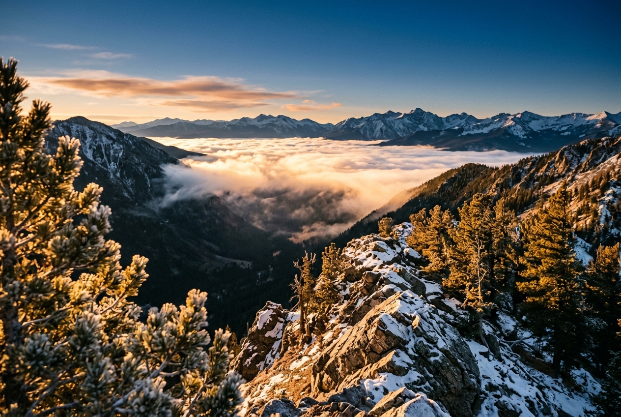
Standing on the crest of an alpine pass in late autumn, the world feels bathed in surprising warmth. At two thousand metres above sea level, the afternoon sun strikes your back with crisp intensity; the air is dry, motionless, and pleasantly mild at 8°C. Below your boots, the mountain flanks fall away into a deep, horseshoe-shaped limestone basin. A serene, milky sea of stratus clouds fills the valley floor three hundred metres down, perfectly flat across its upper boundary, resembling water drawn into an enormous stone basin.
As you lace up your boots and begin the descent into the depression, the change is gradual at first—a gentle freshening of the breeze, a subtle shift in the angle of light. But midway down the valley wall, you step through an invisible, razor-sharp boundary.
Elevation (m)
  2000 |   [ Sunlit Ridge: +8°C, Dry Air, Calm ]
       |            \
  1850 | ~~~~~~~~~~~~ Transition Layer (Sharp Inversion Lid) ~~~~~~~~~~~~
       |            /
  1700 |   [ Valley Basin: -14°C, Stagnant Pool, Suspended Ice Fog ]
       +------------------------------------------------------------------
In the span of a dozen paces, the ambient temperature collapses from mild comfort to bone-chilling cold. The thermometer strapped to your pack plummets by more than fifteen degrees Celsius. Your nostrils sting as the moisture inside them instantly freezes into crystalline shards; your breath no longer dissipates in a lazy cloud but condenses into a thick, persistent fog that hangs motionless in the dead air.
At the bottom of the sinkhole, the world is eerily quiet. There is no whisper of wind through the dwarf pines, no rustle of grass. The air smells sharply of frozen soil, stale pine resin, and the faint, acrid trace of chimney smoke drifting from a distant homestead miles away, flattened into an impossibly thin horizontal sheet that refuse to rise. Looking back up the slope, you can see the sun still illuminating the golden limestone ridges above, yet down here, trapped beneath a ceiling of dense, stagnant air, you are entombed in a natural deep-freeze. You have just walked into a classic Persistent Cold Air Pool.
2. What Is Actually Happening: Unpacking Valley Inversions in Plain English
Under normal atmospheric conditions in the troposphere, air temperature decreases with altitude. As you climb a mountain, the pressure drops, air expands, and it cools at a predictable rate known to meteorologists as the environmental lapse rate. But inside mountain basins, valleys, and enclosed depressions on clear, calm nights, this fundamental rule of thumb is completely inverted: the coldest, densest air settles at the lowest elevations, while warmer air floats above it.
Think of the atmosphere not as an empty void, but as a vast, multi-layered fluid governed by the laws of buoyancy and gravity. When the sun sets behind high mountain ridges, the ground loses heat rapidly by radiating infrared energy directly out to space. If the sky is cloudless and the air is dry, this thermal radiation escapes unchecked into the upper atmosphere. The ground chills quickly, and the thin skin of air in direct contact with the rock and snow cools along with it.
Because cold air is denser and heavier than warm air, it behaves exactly like liquid water poured onto a landscape. It slides off the high peaks and trickles down the slopes in thin, shallow rivulets known as katabatic or drainage winds. These gravity-driven currents flow downhill until they meet an obstacle or pool in the lowest available topographic bowl.
             Radiative Heat Loss to Clear Sky
                    ^   ^   ^   ^   ^
                   [ Cold Mountain Peak ]
                         \
                          \  Katabatic Gravity Flow
                           \   (Dense, Chilled Air)
                            v
   [ Warm Air Cap ]          \
~~~~~~~~~~~~~~~~~~~~~~~~~~~~~~~~~ Inversion Boundary
   [ Cold Air Pool ]          |
   ===========================+==== (Valley Floor / Basin Sink)
In wide, open plains, daytime winds or sweeping synoptic weather systems quickly disperse this chilled layer. But within a sheltered mountain valley or an enclosed limestone sinkhole, the surrounding topography acts as an enormous earthen fortress. The high ridges block ambient regional winds from mixing the atmosphere, creating what fluid dynamicists call topographic sheltering.
Furthermore, inside a deep depression, the ground has a restricted "sky-view factor"—meaning the basin floor receives less direct solar radiation during short winter days due to ridge shading, while the surrounding walls trap and isolate the dense fluid below. The result is a self-reinforcing thermodynamic trap: a Persistent Cold Air Pool (PCAP), where air remains stagnant, subfreezing, and decoupled from the broader atmospheric circulation for days or even weeks at a time.
3. The Science: Thermodynamics, Deficits, and Pool Erosion
To quantify how these cold air pools form, maintain stability, and eventually disintegrate, atmospheric scientists rely on two central physical frameworks: the valley heat deficit and dynamic shear instability.
The Valley Heat Deficit ($Q_d$)
How much energy does it actually take to destroy a valley inversion and restore normal atmospheric mixing? In 1982, the atmospheric scientist C. David Whiteman formulated the concept of the Valley Heat Deficit ($Q_d$).
The heat deficit represents the total quantity of sensible heat energy per unit area that must be injected into a valley atmosphere—either via solar heating of the surface or turbulent downward transfer from above—to warm the air column to an isothermal potential temperature equal to that of the air mass capping the valley crest.
The heat deficit per unit horizontal area of the valley is expressed mathematically as:
$$Q_d = c_p \int_{z_{\text{sfc}}}^{z_{\text{top}}} \rho(z) \left[ \theta(z_{\text{top}}) - \theta(z) \right] \frac{A(z)}{A(z_{\text{top}})} \, dz$$
Where: * $c_p$ is the specific heat capacity of dry air at constant pressure ($1005 \text{ J}\cdot\text{kg}^{-1}\cdot\text{K}^{-1}$). * $z_{\text{sfc}}$ and $z_{\text{top}}$ are the elevations of the valley floor and valley crest (m). * $\rho(z)$ is the atmospheric air density as a function of height ($\text{kg}\cdot\text{m}^{-3}$). * $\theta(z)$ is the potential temperature profile within the valley (K). * $\theta(z_{\text{top}})$ is the potential temperature at the crest height capping the inversion (K). * $A(z)$ is the cross-sectional horizontal area of the valley at height $z$, and $A(z_{\text{top}})$ is the area at the crest.
Worked Example: Calculating a Valley's Thermal Debt
Imagine a symmetrical mountain valley with the following measured characteristics: * Valley depth: $h = z_{\text{top}} - z_{\text{sfc}} = 600 \text{ m}$ (from $z = 0$ to $z = 600 \text{ m}$). * Average atmospheric density: $\rho \approx 1.20 \text{ kg}\cdot\text{m}^{-3}$. * Valley sidewall geometry: V-shaped, such that $A(z) / A(z_{\text{top}}) = z / h$. * The inversion is linear: the potential temperature deficit $[\theta(z_{\text{top}}) - \theta(z)]$ equals $12 \text{ K}$ at the valley floor ($z = 0$) and decreases linearly to $0 \text{ K}$ at the crest ($z = 600 \text{ m}$), expressed as $\Delta \theta(z) = 12 \left(1 - \frac{z}{h}\right)$.
We set up the integral for the total heat deficit $Q_d$:
$$Q_d = c_p \rho \int_{0}^{h} 12 \left(1 - \frac{z}{h}\right) \left(\frac{z}{h}\right) dz$$
Evaluating the polynomial inside the integral:
$$\int_{0}^{h} \left( \frac{z}{h} - \frac{z^2}{h^2} \right) dz = \left[ \frac{z^2}{2h} - \frac{z^3}{3h^2} \right]_{0}^{h} = h \left( \frac{1}{2} - \frac{1}{3} \right) = \frac{h}{6}$$
Substituting our physical parameters into the equation:
$$Q_d = 1005 \text{ J}\cdot\text{kg}^{-1}\cdot\text{K}^{-1} \times 1.20 \text{ kg}\cdot\text{m}^{-3} \times 12 \text{ K} \times \frac{600 \text{ m}}{6}$$
$$Q_d = 1447.2 \times 100 \text{ J}\cdot\text{m}^{-2} = 1.45 \times 10^6 \text{ J}\cdot\text{m}^{-2} = 1.45 \text{ MJ}\cdot\text{m}^{-2}$$
On a clear winter day at mid-latitudes, the net solar sensible heat flux entering the valley floor might only average $35 \text{ W}\cdot\text{m}^{-2}$ over a short 6-hour daylight window ($21,600 \text{ seconds}$), providing a cumulative thermal energy input of:
$$Q_{\text{solar}} = 35 \text{ W}\cdot\text{m}^{-2} \times 21,600 \text{ s} = 0.756 \text{ MJ}\cdot\text{m}^{-2}$$
Because $Q_{\text{solar}} < Q_d$, solar insolation alone cannot supply the energy required to wipe out the heat deficit. The inversion survives the day intact, rolling over into the next night to grow even stronger.
================================================================================
                    VALLEY HEAT DEFICIT ENERGY BALANCE
================================================================================
Required Sensible Heat to Mix Valley ($Q_d$):        1.45 MJ / m²
Available Daily Winter Solar Sensible Flux ($Q_s$):  0.76 MJ / m²
--------------------------------------------------------------------------------
Net Diurnal Energy Balance:                        -0.69 MJ / m² (Deficit Grows)
Status: PERSISTENT COLD AIR POOL REMAINS LOCKED
================================================================================
The Mechanics of Pool Destruction and the Bulk Richardson Number ($Ri_b$)
A cold air pool trapped inside a valley cannot survive indefinitely. Broadly, atmospheric scientists recognize three primary mechanisms that destroy PCAPs:
- Downward Convective Erosion: Solar radiation warms the valley floor, creating an upward-growing convective boundary layer that eats away at the stable layer from below.
- Dynamic Flushing: A powerful, large-scale synoptic cold front or deep pressure gradient drives strong winds directly into the basin, mechanically displacing the pooled cold air like a blast of water scouring out a basin.
- Turbulent Shear Erosion at the Cap: High-velocity winds blow perpendicular to the mountain ridges across the top of the valley. If the wind speed is sufficient, turbulent eddies form along the interface between the fast-moving warm air aloft and the stagnant cold air below, gradually shearing away and entraining the cold air pool from the top down.
Whether top-down shear erosion can successfully mix the air across this interface is dictated by the dimensionless Bulk Richardson Number ($Ri_b$), which balances the stabilizing buoyant forces against the destabilizing forces of wind shear:
$$Ri_b = \frac{g}{\theta_0} \frac{\Delta \theta \cdot h}{(\Delta U)^2}$$
Where: * $g$ is the acceleration due to gravity ($9.81 \text{ m}\cdot\text{s}^{-2}$). * $\theta_0$ is the reference mean potential temperature of the layer (K). * $\Delta \theta$ is the potential temperature jump across the inversion interface (K). * $h$ is the characteristic depth of the shear layer (m). * $\Delta U$ is the velocity difference (wind shear) across the top of the inversion ($\text{m}\cdot\text{s}^{-1}$).
According to classical hydrodynamic stability theory, the critical threshold for shear-driven turbulence is $Ri_c \approx 0.25$.
- If $Ri_b > 0.25$, buoyancy forces suppress turbulence; the stratification is dynamically stable, and the cold air pool remains locked in place while the wind merely skims harmlessly over the ridge crests.
- If $Ri_b < 0.25$, velocity shear overcomes the stabilizing density gradient. Kelvin-Helmholtz instability waves roll up and break along the interface, vigorously mixing warm air downward and eroding the cold pool.
Worked Example: Testing Inversion Stability
Let us calculate whether an incoming windstorm can break a valley inversion under the following conditions: * Mean potential temperature: $\theta_0 = 273.15 \text{ K}$ ($0^\circ\text{C}$). * Inversion temperature jump: $\Delta \theta = 8 \text{ K}$. * Inversion interface boundary thickness: $h = 100 \text{ m}$. * Cross-ridge synoptic wind velocity aloft: $U = 14 \text{ m}\cdot\text{s}^{-1}$ (with stagnant air inside the pool, so $\Delta U = 14 \text{ m}\cdot\text{s}^{-1}$).
We calculate $Ri_b$:
$$Ri_b = \frac{9.81}{273.15} \times \frac{8 \times 100}{(14)^2} = 0.0359 \times \frac{800}{196} = 0.0359 \times 4.082 = 0.147$$
Because $Ri_b = 0.147 < 0.25$, the sheer momentum of the wind aloft overcomes the static stability of the inversion layer. Large turbulent billows will form at the interface, entraining the cold air and steadily venting the valley pool into the broader tropospheric flow.
4. Extreme Microclimatic Phenomena & Real-World Case Studies
Topographic cold pooling reaches its most staggering extremes in enclosed limestone depressions known as sinkholes or dolines. Because these geological formations have no surface drainage outlets, katabatic drainage settles into an absolute dead end.
       Peter Sinks, Utah (Elevation ~2,460 m)
                 [ Surrounding Rim ]
                     \             /
                      \  -20°C    /
                       \         /
                        \ -35°C /
                         \     /
                          \_ _/  <- Floor: -56.3°C (-69.3°F)
                             [ Extreme PCAP Sinkhole ]
The most famous frost hollow in North America is Peter Sinks, an enclosed topographic depression in northern Utah situated at an elevation of roughly 2,460 metres. On 1 February 1985, meteorologists recorded an astonishing minimum temperature of $-56.3^\circ\text{C}$ ($-69.3^\circ\text{F}$) at the basin floor—the second-coldest temperature ever officially recorded in the contiguous United States.
What makes Peter Sinks extraordinary is the sheer vertical compression of its microclimatic gradient. On clear winter nights, field observers have measured temperature jumps exceeding $20^\circ\text{C}$ to $25^\circ\text{C}$ along a vertical climb of just 90 metres up the sinkhole rim. An observer standing at the rim can look down into an active thermal refrigerator where the air cools at rates exceeding $10^\circ\text{C}$ per hour immediately after sunset.
A European counterpart is the famous Gstettneralm Sinkhole near Grünau in the Austrian Alps. Located at an altitude of 1,270 metres, this doline recorded an unofficial temperature of $-52.6^\circ\text{C}$ in 1932. Research conducted by alpine climatologists revealed that the vegetation within the sinkhole is inverted: alpine tundra species normally found at 2,500 metres flourish on the frost-ravaged basin floor, while mature subalpine spruce trees grow exclusively along the upper rim where winter temperatures are routinely twenty degrees warmer.
Data recorded by the NOAA National Centers for Environmental Information and mountain weather research groups consistently demonstrate that these microclimatic pockets decouple almost entirely from the regional synoptic air mass, maintaining sub-zero conditions even during massive mid-winter warm-air advection events.
5. The Observer’s Toolkit: Diagnosing Inversions in the Wild
For hikers, mountaineers, field naturalists, and gardeners, identifying the presence and boundaries of a cold air pool is both an intellectual thrill and an essential safety skill.
        FIELD DIAGNOSTIC MARKERS OF A COLD AIR POOL

 1. Visual Marker:     [ Flat, Planar Smoke Lid / Trapped Aerosols ]
                             |
 2. Boundary Layer:    [ Rime Ice Line on Tree Trunks & Needles ]
                             |
 3. Optical Cue:       [ Mirage Distortions & Superior Mirages ]
                             |
 4. Atmospheric Sound: [ Dead Acoustic Silence / Sound Ducts ]
What to Look For in the Sky and Landscape
- The Planar Smoke Lid: When woodsmoke from a cabin or campfire rises a short distance and then abruptly flattens into a razor-thin, horizontal sheet spreading out laterally across the valley, you are looking directly at the base of the inversion layer. The smoke parcel ascends only until its buoyancy matches that of the surrounding air, marking the equilibrium height.
- The Rime Ice Horizon: In mountain terrain, inspect the trees along the valley slopes. A sharp horizontal line often separates rime-encrusted pines below (where supercooled valley fog has frozen onto cold needles) from completely clear, dry trees just fifty metres higher up the slope.
- Superior Mirages and Atmospheric Shimmer: Extreme vertical temperature gradients alter the refractive index of air, causing distant ridgelines to appear vertically stretched, flattened, or inverted—an optical signature of strong temperature stratification.
What Instrument Readings to Watch
- Digital Fast-Response Thermistors: If you carry a portable digital weather station or a watch with a barometric altimeter and external temperature sensor, log both parameters as you descend into a valley. A normal lapse rate shows temperature increasing by roughly $0.65^\circ\text{C}$ for every 100 metres of descent ($6.5^\circ\text{C}/\text{km}$). If your instrument records dropping temperatures during a descent, you have entered an inversion.
- Barometric Pressure Trends: A sharp increase in station barometric pressure combined with dying ambient winds is the classic synoptic recipe for pool formation. As a high-pressure ridge passes overhead, large-scale subsidence (sinking air) warms the atmosphere aloft, reinforcing the capping lid over the radiative valley pool below.
- Sounding Profiles (Skew-T Log-P): Professional meteorologists track inversions via operational weather balloon soundings. By consulting public meteorological tools provided by services like the Met Office or the World Meteorological Organization, one can observe the classic "dog-leg" rightward spike in temperature immediately above the ground on a Skew-T log-P diagram, indicating extreme thermodynamic stability.
6. Today’s Meteorological Rule of Thumb
When the night sky is clear, the winds are dead calm, and the terrain forms a bowl, never pitch your tent on the valley floor—seek the thermal belt halfway up the slope, where the mountain's warm breath floats above the frost.
Summary Reference Table: Valley Inversion Dynamics
| Dynamic Feature | Physical Driver | Mathematical Governing Metric | Field Indicator |
|---|---|---|---|
| Pool Formation | Longwave Radiative Cooling & Katabatic Drainage | $Q_{\text{rad}} = \epsilon \sigma T^4$ | Sinking dense air, fog pooling in basins |
| Inversion Strength | Topographic Sheltering & Basin Geometry | $Q_d = c_p \int \rho \Delta \theta \frac{A(z)}{A_{\text{top}}} dz$ | Vertical temperature jumps of $10\text{–}25^\circ\text{C}$ on sidewalls |
| Shear Destruction | High-Velocity Synoptic Winds Aloft | $Ri_b = \frac{g}{\theta_0} \frac{\Delta \theta \cdot h}{(\Delta U)^2} < 0.25$ | Breaking Kelvin-Helmholtz billow clouds along ridge tops |
| Convective Erosion | Diurnal Solar Surface Heating | Sensible Heat Flux $H = \rho c_p C_h U (\theta_s - \theta_a)$ | Upward-growing mixed layer burning off morning mist |