Coastal Trapped Disturbances & Marine Layer Surges: How Topographic Trapping and Internal Kelvin Waves Propagate Abrupt Cool Fronts
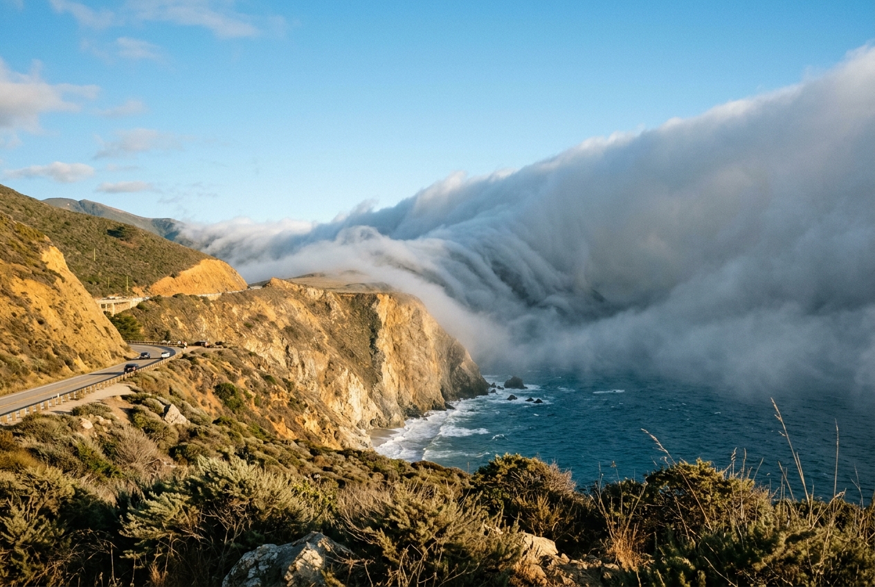
1. Opening Scene: The Sudden Chill on the Bluff
Stand upon a sun-bleached coastal bluff along the California headlands of Point Reyes in mid-July, and the midday atmosphere feels deceptively Mediterranean. The ambient air registers a blistering 33°C (91°F). The chaparral-covered hillsides radiate a dry, herbaceous scent of sage, fennel, and sun-baked earth. A faint, languid breeze drifts out of the northwest, barely rustling the golden grasses, while the cloudless sky arches overhead in an unbroken expanse of cobalt blue.
Then, with an almost supernatural abruptness, the atmosphere stalls. The gentle northwest breeze drops to a dead, suffocating calm. The air feels heavy, pressurized, charged with an unannounced transition.
Looking south past the outer headlands, the horizon vanishes. A colossal, opaque wall of gunmetal-grey stratus cloud, hundreds of metres tall and sheared off flat at its upper boundary, charges relentlessly northward along the coastline. It moves not with the meandering drift of ordinary cloud cover, but with the focused, destructive momentum of a hydraulic bore.
Seconds later, the front hits. The wind does not merely pick up; it violently reverses 180 degrees, snapping into a howling, gale-force southerly. The ambient temperature plummets by 14°C in under eight minutes. Warm, desiccated continental air is violently displaced by a bone-chilling, moisture-saturated marine current smelling intensely of cold upwelled brine, kelp, and pulverised sea salt. Your skin instantly dampens as microscopic water droplets condense across every surface. The sun is snuffed out into a dim, ghostly halo before disappearing entirely behind a churning, low-level fog bank. Inland, only three kilometres to the east beyond the ridge, the valleys remain baked in brilliant, untouched heat.
This dramatic meteorological ambush is neither a conventional cold front nor an ordinary sea breeze. It is a Coastal Trapped Disturbance (CTD)—a hybrid fluid dynamical phenomenon in which the Earth's rotation, steep coastal topography, and sharp atmospheric stratification conspire to forge a one-dimensional highway for trapped atmospheric waves and density currents.
2. What's Actually Happening: The Atmospheric Cake in a Channel
To understand why this marine air behaves like a liquid rushing through a flume rather than spreading out peacefully over the open ocean, it helps to dismantle the atmosphere into a simple mechanical model.
Think of the lower atmosphere along Mediterranean and west-coast climates as a two-layered cake:
- The Dense, Cold Base (The Marine Boundary Layer): Resting directly against the cold, upwelling ocean waters is a thin slice of air—typically 200 to 600 metres deep—that is cold, water-logged, and dense.
- The Warm, Dry Top Layer (The Free Troposphere): Sitting directly above this marine slice is an immense mass of warm, dry, sun-heated air sinking down from the broad subtropical high-pressure systems.
Because warm air is buoyant and cold air is dense, these two layers do not easily mix. The boundary between them acts like a nearly impenetrable ceiling known as a subsidence inversion. In thermal profiles documented by the World Meteorological Organization (WMO), this inversion represents an inverted thermal gradient where temperature abruptly jumps upward with height rather than cooling.
Now, introduce the geography of a mountainous coastline. Along western North America, southern Africa, and western South America, rugged coastal mountain ranges rise steeply to elevations of 800 to 2,000 metres—far higher than the shallow 400-metre marine layer.
The cold marine layer is thus trapped on three sides: * Below, by the sea surface. * Above, by the rigid thermal ceiling of the inversion. * To the east (inland), by the impenetrable vertical wall of the coastal mountains.
When a localized pressure difference develops along the coast—for example, when an inland thermal low shifts position and creates higher pressure to the south—this shallow, trapped slab of cold air wants to rush toward the lower pressure. As it surges forward, it cannot expand inland because the mountains physically block it. Crucially, as described in the AMS Glossary of Meteorology, it cannot simply spill westward into the broad Pacific either. The rotation of the Earth exerts a sideways deflecting push that constantly pins the rushing fluid tight against the mountain flank, forcing the entire marine layer to surge along the coastline as a tightly bound, fast-moving atmospheric wave.
3. The Science: Fluid Mechanics, Wave Speeds, and Topographic Trapping
Coastal Trapped Disturbances represent an exquisite convergence of mesoscale thermodynamics and geophysical fluid dynamics. When atmospheric scientists analyze these events, they evaluate three non-negotiable structural prerequisites:
- A shallow, dense Marine Boundary Layer (MBL) characterized by high relative humidity and low potential temperature.
- A sharp, capping subsidence inversion that limits vertical displacement and creates an effective density interface between two distinct fluid layers.
- A continuous coastal mountain barrier whose physical crest significantly exceeds the height of the inversion layer ($h_{topo} > h_{inv}$), preventing trans-barrier flow and enforcing a rigid kinematic lateral boundary condition.
To formalize the behavior of this trapped fluid layer, we employ shallow-water theory adapted for continuously stratified, density-coupled atmospheric flows.
Phase 1: Reduced Gravity and Internal Wave Phase Speed
Because the marine layer is not moving through a vacuum, but is instead submerged beneath another fluid layer (the warm free troposphere), the effective gravitational restoring force acting upon any vertical disturbance at the inversion interface is dramatically reduced.
We quantify this via the reduced gravity parameter ($g'$), which measures the buoyancy deficit between the two air masses:
$$g' = g \left( \frac{\Delta \theta}{\theta_0} \right) = g \left( \frac{\theta_{upper} - \theta_{marine}}{\theta_0} \right)$$
- Where $g$ is the standard gravitational acceleration ($9.81\text{ m s}^{-2}$).
- $\Delta \theta$ is the potential temperature jump across the capping inversion (in Kelvin).
- $\theta_0$ is the reference potential temperature of the lower layer.
Any localized perturbation in the height of the marine layer generates an internal gravity wave. In a non-rotating or laterally bounded framework, the theoretical linear phase propagation speed ($c$) of this internal shallow-water wave is governed by the reduced gravity and the marine layer depth ($h$):
$$c = \sqrt{g' h}$$
Consider a typical summertime marine surge along the central California coast: * Marine layer potential temperature ($\theta_{marine}$): $288\text{ K}$ ($15^\circ\text{C}$) * Upper troposphere potential temperature ($\theta_{upper}$): $303\text{ K}$ ($30^\circ\text{C}$) * Inversion strength ($\Delta \theta$): $15\text{ K}$ * Reference temperature ($\theta_0$): $288\text{ K}$ * Marine layer base depth ($h$): $400\text{ m}$
First, calculate the reduced gravity: $$g' = 9.81 \times \left( \frac{15}{288} \right) = 9.81 \times 0.05208 \approx 0.511\text{ m s}^{-2}$$
Next, calculate the linear internal wave speed ($c$): $$c = \sqrt{0.511\text{ m s}^{-2} \times 400\text{ m}} = \sqrt{204.4} \approx 14.30\text{ m s}^{-1} \approx 51.5\text{ km h}^{-1} \text{ (27.8 knots)}$$
This demonstrates mathematically why coastal fog surges advance with vehicular speed along coastal headlands, sweeping past coastal outposts in a matter of hours.
Phase 2: The Internal Rossby Radius and Cross-Shore Geostrophy
Why does this surge remain trapped within a narrow ribbon along the shoreline rather than diffusing outward across the open ocean? The answer lies in the Coriolis parameter ($f = 2\Omega \sin\phi$, where $\Omega$ is Earth's angular velocity and $\phi$ is latitude).
When the dense marine fluid accelerates along the coastline, the Coriolis force continuously deflects the flow perpendicular to its direction of motion. In the Northern Hemisphere, this deflection is always to the right. As the northward-surging fluid turns right, it slams into the immovable coastal mountain wall. The fluid banks up against the topography, creating an elevated marine wedge whose height ($h$) slopes downward toward the open sea.
This cross-shore slope establishes an offshore-directed hydrostatic pressure gradient force that precisely balances the onshore Coriolis force, resulting in a cross-shore geostrophic balance:
$$f v = g' \frac{\partial h}{\partial x}$$
- Where $v$ is the alongshore surge velocity.
- $\frac{\partial h}{\partial x}$ is the cross-shore slope of the marine layer interface.
Because the coastal wall prevents lateral dispersion to the right, the disturbance propagates along the boundary as an Internal Kelvin Wave, a special class of boundary-trapped wave detailed extensively in classical geophysical fluid dynamics and the Wikipedia entry on Kelvin waves. The offshore scale over which the marine layer thickness exponentially decays to its unperturbed ambient state is defined by the Internal Rossby Radius of Deformation ($R_D$):
$$R_D = \frac{\sqrt{g' h}}{f} = \frac{c}{f}$$
Using our wave speed from Example 1 ($c = 14.30\text{ m s}^{-1}$) at a mid-latitude coastal location ($\phi = 38^\circ\text{ N}$ near San Francisco):
-
Calculate the Coriolis parameter: $$f = 2 \times (7.2921 \times 10^{-5}\text{ rad s}^{-1}) \times \sin(38^\circ) \approx 8.979 \times 10^{-5}\text{ s}^{-1}$$
-
Calculate the Rossby deformation radius ($R_D$): $$R_D = \frac{14.30\text{ m s}^{-1}}{8.979 \times 10^{-5}\text{ s}^{-1}} \approx 159,260\text{ m} \approx 159.3\text{ km}$$
In reality, surface friction, non-linear advection, and horizontal shear across the coastal boundary layer contract the effective trapping width down to approximately 50 to 100 km. This mathematical constraint proves that the surge is physically incapable of dispersing across the broad ocean basin; it is mathematically imprisoned against the coastal topography.
Phase 3: Nonlinear Steepening—From Wave to Gravity Current and Bore
As a linear Kelvin wave propagates into a shallowing or slowing ambient marine layer, non-linear advective terms ($u \frac{\partial u}{\partial x}$) become dominant. The higher, deeper crest of the trailing wave travels faster than the shallow leading trough ($c \propto \sqrt{h}$). Consequently, the wave face steepens dramatically, transitioning from a smooth, continuous wave into a turbulent, non-linear atmospheric bore or density current head.
This hydraulic transition is classified by the internal Froude number ($Fr$):
$$Fr = \frac{v}{\sqrt{g' h}}$$
- When $Fr < 1$ (Subcritical): The disturbance behaves as an undular internal Kelvin wave packet.
- When $Fr \ge 1$ (Supercritical): The wave breaks non-linearly, forming an elevated, turbulent "head" with intense Kelvin-Helmholtz shear instability billows along the upper inversion interface, driving intense vertical mixing and mechanical turbulence.
Phase 4: Hemispheric Propagation Rules
A fundamental law of coastal trapped disturbances is that the boundary wall must always lie on the side toward which the Coriolis acceleration directs the flow. This creates distinct propagation vectors across the globe:
| Geographic Region | Coastline Alignment | Ocean Position | Deflection Direction | Permitted Propagation | Regional Name |
|---|---|---|---|---|---|
| Western USA (California, Oregon) | North–South | West | Right (Eastward) | Northward | Southerly Surge |
| Southeastern Australia (NSW, Victoria) | North–South | East | Left (Westward) | Northward | Southerly Buster |
| Western South America (Central Chile) | North–South | West | Left (Eastward) | Southward | Chilean Coastal Low / Surge |
| Southern Africa (South Africa, Namibia) | West–East / N–S | South / West | Left (Toward coast) | Eastward / Northward | Coastal Low |
In the Northern Hemisphere, cold air moving northward has the coastal mountains on its right; the Coriolis force continuously deflects the flow eastward into the mountain barrier, preserving the wave. If a surge attempted to move southward, Coriolis deflection would pull the fluid westward away from the coast, immediately destroying the topographic trapping mechanism.
In the Southern Hemisphere, the Coriolis force deflects moving parcels to the left. Along the eastern seaboard of Australia (where the Tasman Sea lies to the east and the Great Dividing Range to the west), cold Antarctic air blasting northward feels a leftward Coriolis push directly into the mountains. This sustains Australia's renowned Southerly Buster, a fierce trapped density current documented by the UK Met Office and the Australian Bureau of Meteorology that can generate coastal wind gusts exceeding 50 knots.
4. Practical Outdoor Guidance: Diagnosing Impending Surges
For mariners, coastal aviators, hikers, and meteorological observers, identifying a Coastal Trapped Disturbance prior to its arrival is critical for safety. The passage of a CTD brings severe low-level wind shear, immediate loss of visual flight conditions, and dangerous sea-state changes.
1. Real-Time Instrument Diagnostics
- Barometric Pressure: Watch for a distinctive, sharp inflection known as a "pressure jump" or "step." Unlike the gradual barometric decline preceding a synoptic low, an approaching CTD manifests as an abrupt pressure rise of $+2.0\text{ to }+5.0\text{ hPa}$ within a 30-minute window, caused by the sudden arrival of the dense marine air column.
- Surface Thermometer: An unseasonably hot afternoon along the immediate coast that abruptly stops rising and collapses by more than $10^\circ\text{C}$ in minutes is the primary thermal signature of the advancing density current.
- Buoy Array Monitoring: Access real-time data from the NOAA National Data Buoy Center (NDBC). Track offshore buoys positioned 50 to 100 nautical miles upstream (south in the Northern Hemisphere). Look for sequential stations recording an instantaneous 180° wind shift from prevailing northwesterlies to gale-force southerlies, accompanied by a spike in wave steepness and water-temperature drops.
2. Sky and Satellite Observations
- Visual Horizon Cues: Look toward the upstream horizon for a crisp, low-altitude grey boundary beneath an otherwise cloudless sky. As the disturbance nears, this boundary reveals an undulating, shelf-like head (the bore wave) rolling along the ridgeline.
- Geostationary Satellite Channels: On GOES shortwave infrared and split-window channels ($10.3 - 3.9\ \mu\text{m}$ "fog product"), CTDs appear as a sharply defined, bright, narrow "stratus finger" advancing rapidly along the coastline like toothpaste squeezed along a wall, hugging within 100 km of the shore.
3. Practical Rules of Thumb for Field Observers
- The Hiker's Gap Rule: If you are hiking along a coastal crest and observe fog pouring through mountain passes and gaps from south to north (rather than the usual west-to-east sea breeze penetration), you are witnessing a trapped surge advancing at speed. Seek immediate shelter and prepare for sub-$10^\circ\text{C}$ exposure conditions.
- The Sailor's Headland Law: When sailing along a mountainous coastline under light trailing winds, if an upstream headland 10 miles away suddenly disappears into fog while your local barometer ticks upward, drop sail area immediately. The wind will not shift gradually; it will impact as an instantaneous headwind shear within 30 minutes.
5. Today's Meteorological Rule of Thumb
When a blazing coastal afternoon abruptly falls dead calm and the barograph spikes, look upstream along the mountain barrier: the Earth's rotation is banking a wall of trapped ocean fog against the cliffs, and a 180-degree gale will arrive before the hour is out.
External References & Further Reading
- National Oceanic and Atmospheric Administration (NOAA) — Marine boundary layer dynamics and mesoscale forecasting.
- NOAA National Data Buoy Center (NDBC) — Real-time coastal oceanographic and meteorological buoy observations.
- World Meteorological Organization (WMO) International Cloud Atlas — Classification of low-level stratus, fog, and roll cloud formations.
- American Meteorological Society (AMS) Glossary — Formal definitions of coastal trapped disturbances and Kelvin waves.
- Met Office (UK) — Synoptic and mesoscale boundary-layer meteorology.
- Wikipedia: Coastal Trapped Disturbance — Overview of global trapped surge phenomena.