Bounded Weak Echo Region (BWER) & Updraft Vault Dynamics: How Extreme Convective Velocities Suspend Hydrometeors and Unmask Severe Storm Cores
1. Opening Scene: The Calm Under the Canopy
On a sweltering midsummer afternoon across the undulating plains, the atmosphere takes on a heavy, almost suffocating stillness. The air is thick with humidity, clinging to the skin like a warm, wet woollen blanket. For hours, the sun has baked the sodden soils, loading the lowest kilometre of the planetary boundary layer with invisible water vapour. To the southwest, the horizon begins to curdle. What started as benign, cauliflower-topped cumulus clouds has rapidly congealed into a towering, solitary monolith that punches through the troposphere, flattening out against the stable stratosphere into a vast, polished anvil of cirrus.
As you stand beneath the eastern flank of this developing giant, the sensory cues shift with dramatic rapidity. The ambient temperature, which had hovered near thirty-two degrees Celsius, dips subtly as a cool, laminar breeze begins to draw inward toward the storm, rustling the dry grasses. The unmistakable, earthy perfume of petrichor—the chemical signature of geosmin and plant oils liberated by distant raindrops hitting hot soil—drifts across the landscape. Yet directly overhead, no rain falls.
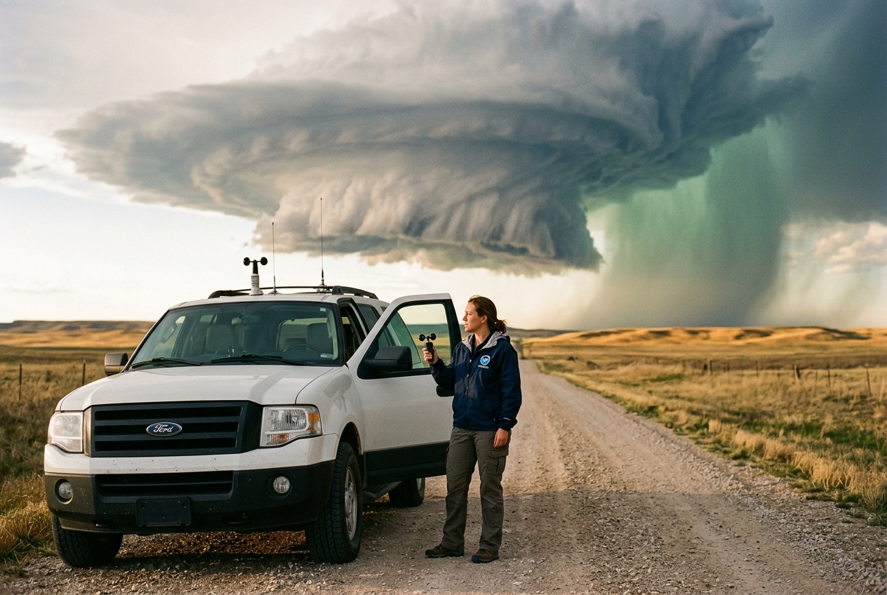
Looking up into the storm’s southern flank, the cloud base is startlingly crisp and flat. This is not the chaotic, ragged underbelly of an ordinary summer squall, but an immaculate, slate-grey, rain-free base that looks almost machined in its smoothness. Above this dark pedestal, the cloud flesh twists in tight, helical striations, resembling the grooves of an enormous barbershop pole or an architectural turbine spinning in slow motion. Higher still, suspended directly above the rain-free base, hangs a monumental, bulbous overhang of condensed vapour. While several kilometres to the north a charcoal-coloured curtain of torrents and hail tears into the tree lines with a deafening roar, the air directly beneath this majestic overhang remains entirely devoid of precipitation. The atmospheric pressure drops precipitously; your ears register the subtle pop of expanding air. You are standing directly beneath the updraft vault—the engine room of a severe supercell thunderstorm—where millions of tonnes of air are being hoisted skyward with the velocity of an express train.
2. What is Actually Happening: The Physics of the Cloud Vault
To understand why the most violent portion of a storm can appear completely hollow to meteorological radar, one must explore the peculiar fluid mechanics of deep, moist convection.
Think of the atmosphere as a vast, layered cake. Each layer possesses a slightly different temperature, moisture content, and density. On a quiet morning, these layers rest comfortably in hydrostatic equilibrium, with cold, dense air sitting beneath warmer, less dense air, or cooling at a gentle, stable rate as one ascends. However, intense solar heating at the Earth's surface can radically disrupt this balance. The ground acts like a stove burner, heating the lowest layer of air until it becomes significantly warmer and less dense than the air resting immediately above it.
When this warm, buoyant pocket of air is nudged upward—perhaps by an advancing cold front, an undulating terrain ridge, or an outflow boundary from a decaying storm—it begins to rise just like a hot-air balloon. As it climbs into regions of lower atmospheric pressure, the parcel expands. This expansion costs thermal energy, causing the parcel to cool adiabatically. If the rising parcel contains abundant moisture, it eventually cools to its dew point: water vapour condenses into microscopic liquid droplets, releasing latent heat of condensation. This liberated heat warms the parcel further, making it even more buoyant than the surrounding ambient environmental air.
       ================ RADAR VAULT CROSS-SECTION ================
       Altitude
        (km)
         12 |                  .................
         10 |             .:::#############:::::::.  <-- Echo Overhang
          8 |          .:::::### [HAIL] ###::::::::.     (Large Hydrometeors)
          6 |        .:::::##               ##:::::::.
          4 |       .::::##   BOUNDED WEAK   ##::::::.
          2 |      .:::##     ECHO REGION     ##:::::: <-- Reflectivity Walls
          0 | ____.:::##____  (w > 40 m/s)   __##::::::________________
                 0         5        10        15        20    Distance (km)
                  [ Inflow / Rain-Free Base ]  [ Downburst / Precip ]
       ===========================================================
In an ordinary garden-variety thunderstorm, this rising column of air—the updraft—is relatively weak, rarely exceeding ten to fifteen metres per second. Precipitation forms quickly, accumulates within the updraft column, and soon becomes too heavy for the rising air to support. The weight of the accumulated rain and hail drags the air back down, generating a downdraft that cuts off the updraft’s supply of warm surface air, causing the storm to choke and dissipate within forty-five minutes.
Supercell thunderstorms, however, avoid this self-destructive fate through the agency of vertical wind shear—a change in wind speed and direction with height. When strong environmental winds turn and accelerate with altitude, the rising updraft is tilted and set into continuous rotation, transforming into a coherent, helical vortex known as a mesocyclone.
In 1962, the British meteorologist Keith Browning, studying detailed radar observations of the infamous Wokingham storm over Berkshire, made a fundamental discovery. Examining vertical radar cross-sections, Browning identified a persistent, cavernous region within the core of the storm that returned virtually no radar signal, despite being situated beneath an immense, highly reflective overhang of hail. Browning initially termed this feature the "echo-free vault"; modern meteorology categorises it as the Bounded Weak Echo Region (BWER).
The existence of the BWER presents a fascinating paradox: why should the most energetic and moisture-dense core of a violent thunderstorm appear empty to radar?
The answer lies in the physics of radar reflectivity and particle growth kinetics. Weather radars operate by transmitting microwave pulses and measuring the electromagnetic energy backscattered by atmospheric targets. Under the laws of Rayleigh scattering, when cloud droplets are much smaller than the radar's wavelength (typically 3 to 10 centimetres), the backscattered radar reflectivity factor, denoted as $Z$, is proportional to the sixth power of the hydrometeor diameter ($D$):
$$Z = \sum D_i^6$$
This sixth-power dependency has profound consequences. If you double the diameter of a water droplet, its radar reflectivity does not double; it increases by a factor of $2^6 = 64$. A single hailstone measuring two centimetres across reflects millions of times more radar energy than thousands of tiny cloud droplets measuring twenty micrometres across.
In the core of a supercell mesocyclone, the updraft is so exceptionally violent—often surging upward at speeds between 30 and 60 metres per second (100 to 200 km/h)—that air parcels are propelled through the lower and middle troposphere in mere tens of seconds. Even though this air parcel cools past the freezing level (the zero-degree isotherm) almost instantly, the microphysical processes of droplet collision, coalescence, and freezing require time.
Cloud condensation nuclei simply do not have sufficient residence time during their rapid vertical journey to accrete into millimetre-sized raindrops or centimetre-sized hailstones. The updraft core remains filled exclusively with billions of newly condensed, sub-millimetre cloud droplets and unactivated vapour. Because their diameters are tiny, their combined reflectivity remains exceptionally low, registering values typically below 20 dBZ on the decibel reflectivity scale used by operational meteorologists at bodies such as the National Oceanic and Atmospheric Administration (NOAA) and the Met Office.
Surrounding this high-speed conduit of fresh air, the physical dynamics change. As the rising air parcel approaches the upper troposphere, near the equilibrium level, its vertical momentum decelerates against the stable stratospheric boundary. The air is deflected horizontally around the rotating mesocyclone. In these flanking regions, where the vertical ascent slows, ice crystals and supercooled water droplets linger long enough to undergo rapid riming and wet growth, accreting into massive hailstones. These heavy hydrometeors fall out of the decelerating updraft along its periphery, forming a cascading curtain of high reflectivity (frequently exceeding 60 to 70 dBZ) that wraps around the echo-free core.
On a horizontal radar scan, this structural geometry reveals the classic "hook echo"; on a vertical cross-section, it presents as an inverted cup or vault of near-zero echo, bounded on all sides and above by towering walls of intense reflectivity. The radar vault is not an empty space, but a physical geyser of pure, uncoagulated kinetic energy.
3. The Science: Energy, Aerodynamics, and the Mechanics of Levitation
To rigorously quantify the dynamics maintaining the BWER, we must examine the thermodynamic potential of the ambient atmosphere and the aerodynamic forces governing particle suspension.
Equation 1: Updraft Velocity from Thermodynamic Potential
The theoretical upper limit of a convective updraft's vertical velocity is determined by the total buoyant energy available to an ascending air parcel. This quantity is known as Convective Available Potential Energy (CAPE), which represents the integrated positive buoyancy of a parcel lifted from its level of free convection ($z_{\text{LFC}}$) to its equilibrium level ($z_{\text{EL}}$).
In plain English, CAPE measures the total accumulated thermal energy that the atmosphere can convert into upward kinetic energy. By applying the work-energy theorem to an undiluted air parcel, the maximum theoretical vertical velocity ($w_{\text{max}}$) achievable at the storm core can be derived from the conservation of energy:
$$\frac{1}{2} m w_{\text{max}}^2 = m \cdot \text{CAPE} \implies w_{\text{max}} = \sqrt{2 \cdot \text{CAPE}}$$
Where: * $w_{\text{max}}$ is the maximum theoretical vertical updraft velocity ($\text{m}\cdot\text{s}^{-1}$), * $\text{CAPE}$ is the Convective Available Potential Energy expressed in Joules per kilogram ($\text{J}\cdot\text{kg}^{-1}$ or $\text{m}^2\cdot\text{s}^{-2}$).
Worked Example:
Consider a severe convective environment surveyed ahead of a supercell outbreak across the central United States or southern Europe. Atmospheric sounding data analysed by the World Meteorological Organization (WMO) reveals extreme thermodynamic instability with a calculated surface-based $\text{CAPE} = 3,200\text{ J}\cdot\text{kg}^{-1}$.
Applying the theoretical velocity relationship:
$$w_{\text{max}} = \sqrt{2 \cdot 3,200\text{ J}\cdot\text{kg}^{-1}} = \sqrt{6,400\text{ m}^2\cdot\text{s}^{-2}} = 80.0\text{ m}\cdot\text{s}^{-1}$$
An undiluted parcel could theoretically attain a vertical speed of $80\text{ m/s}$ (equivalent to $288\text{ km/h}$ or $179\text{ mph}$). In the real atmosphere, environmental entrainment (the mixing of dry, cool ambient air into the updraft flanks), adverse vertical perturbation pressure gradients, and the physical weight of suspended condensed water (water loading) dilute this maximum potential. Observational Doppler radar and aircraft penetrations establish that actual sustained updrafts achieve approximately $50\%$ to $70\%$ of the theoretical maximum:
$$w_{\text{actual}} \approx (0.55 \text{ to } 0.65) \cdot w_{\text{max}} \approx 0.60 \cdot 80.0\text{ m}\cdot\text{s}^{-1} \approx 48.0\text{ m}\cdot\text{s}^{-1}$$
Even at $48\text{ m/s}$, a parcel traverses a 5-kilometre vertical depth (from the freezing level at $3.5\text{ km}$ to the $-40^\circ\text{C}$ homogeneous nucleation level at $8.5\text{ km}$) in just under $104\text{ seconds}$. This duration is far too brief for cloud droplets to develop the multi-millimetre diameters necessary to produce substantial radar backscatter, mathematically ensuring the maintenance of the BWER.
Equation 2: Aerodynamic Suspension and Hailstone Terminal Velocity
For high-reflectivity hydrometeors (such as hailstones) to remain suspended above and around the BWER—forming the structural "overhang" and "vault walls"—the vertical updraft velocity $w(z)$ at a given altitude $z$ must equal or exceed the terminal fall velocity ($v_t$) of the particle.
The terminal velocity of a falling spherical body is reached when the downward gravitational force ($F_g = m g$) is precisely balanced by the upward aerodynamic drag force ($F_d = \frac{1}{2} \rho_a A C_d v_t^2$). Setting $F_g = F_d$:
$$m g = \left( \frac{4}{3} \pi \left(\frac{D}{2}\right)^3 \rho_h \right) g = \frac{1}{2} \rho_a \left( \pi \left(\frac{D}{2}\right)^2 \right) C_d v_t^2$$
Solving for the terminal fall velocity $v_t$:
$$v_t = \sqrt{\frac{4 \rho_h g D}{3 \rho_a C_d}}$$
Where: * $D$ is the hailstone diameter ($\text{m}$), * $\rho_h$ is the density of the hailstone (typically $\sim 900\text{ kg}\cdot\text{m}^{-3}$ for dense ice), * $\rho_a$ is the density of the ambient air at the suspension altitude ($\sim 0.70\text{ kg}\cdot\text{m}^{-3}$ at $5\text{ km}$ above sea level), * $g$ is the acceleration due to gravity ($9.81\text{ m}\cdot\text{s}^{-2}$), * $C_d$ is the dimensionless aerodynamic drag coefficient (empirically determined to be approximately $0.55$ for rough, irregular hailstones).
This confirms the classical scaling law: the terminal fall velocity of a hailstone scales with the square root of its diameter:
$$v_t \propto \sqrt{D}$$
Worked Example:
Calculate the suspension threshold for a severe, golf-ball-sized hailstone with diameter $D = 0.045\text{ m}$ ($4.5\text{ cm}$) suspended in the echo overhang at an altitude of $5\text{ km}$ ($\rho_a = 0.70\text{ kg}\cdot\text{m}^{-3}$):
$$v_t = \sqrt{\frac{4 \cdot (900\text{ kg}\cdot\text{m}^{-3}) \cdot (9.81\text{ m}\cdot\text{s}^{-2}) \cdot (0.045\text{ m})}{3 \cdot (0.70\text{ kg}\cdot\text{m}^{-3}) \cdot 0.55}}$$
$$v_t = \sqrt{\frac{1,589.22}{1.155}} = \sqrt{1,375.95} \approx 37.1\text{ m}\cdot\text{s}^{-1}$$
Updraft Tilt and Environmental Shear Dynamics
The spatial geometry of the BWER is strictly governed by deep-layer vertical wind shear. If a storm updraft rose purely vertically, the enormous reservoir of hail accumulating aloft would eventually load the updraft core with excess mass, causing it to collapse.
To maintain a steady-state BWER, the updraft column must tilt. The angle of tilt ($\theta$) relative to the vertical axis is determined by the balance between vertical convective buoyancy ($w$) and the horizontal momentum transferred by the environmental shear vector across the depth of the troposphere ($\Delta \mathbf{u} = \mathbf{u}{\text{upper}} - \mathbf{u}{\text{surface}}$):
$$\tan \theta \approx \frac{|\Delta \mathbf{u}|}{w_{\text{mean}}}$$
When strong vertical shear ($|\Delta \mathbf{u}| \ge 25\text{ m}\cdot\text{s}^{-1}$ over the lowest $6\text{ km}$) interacts with the rotating mesocyclone, the updraft tilts downstream and cross-stream. This physical separation ensures that the primary precipitation cascade falls safely into the Forward-Flank Downdraft (FFD) and Rear-Flank Downdraft (RFD) zones, leaving the high-speed core of the BWER entirely unencumbered by falling water mass.
4. Practical Outdoor Guidance and Field Diagnostics
Understanding the mechanics of the BWER is not merely an academic exercise; it provides essential diagnostic tools for field observers, pilots, sailors, and severe weather spotters.
       ================ RHI RADAR DIAGNOSTIC SIGNATURE ================
       Altitude
        (km)
         14 |                      OVERSHOOTING TOP
         12 |                          ______
         10 |                       .-'      '-.
          8 |                     .'  65 dBZ    '.  <-- Suspended Core
          6 |                   .'    (HAIL)      '.
          4 |                  /     ________       \
          2 |                 |     /  BWER  \       |  <-- High Shear Tilt
          0 | ____[Radar]____/_____|  <20 dBZ |______|____[Ground Target]
                                   \__________/
       ================================================================
Sky Observations: Identifying the Vault Visually
When observing a supercell from a safe vantage point in the warm inflow sector (typically to the southeast of an eastward-moving storm in the Northern Hemisphere):
- The Rain-Free Base: Look for a dark, persistently flat cloud base devoid of falling rain streaks (virga). If this base is rotating or exhibiting rapid upward scud movement, you are looking directly at the base of the BWER updraft.
- The Striated Vault Overhang: Look upward above the rain-free base. A massive, sculpted shelf of cloud that appears to jut out over clear air marks the visual manifestation of the radar echo overhang.
- The Greenish-Turquoise Tint: As sunlight passes through the high-density suspension of liquid water droplets and large hailstones flanking the BWER, red light is selectively absorbed and scattered, casting a distinctive bruised green or turquoise hue across the sky beneath the overhang. This optical signature strongly correlates with giant hail ($D > 4\text{ cm}$).
Instrument Readings: Barometric and Thermal Signatures
- Barometric Pressure: A rapid, localized plunge in atmospheric pressure (often 2 to 5 hPa within 15 minutes) as the mesocyclone approaches, followed by a violent, spike-like pressure jump (thunderstorm wake depression to mesohigh transition) as the downdraft begins.
- Surface Wind Direction: Watch for backing winds. In the Northern Hemisphere, if surface winds back from westerly to southeasterly while strengthening to $10\text{--}20\text{ m/s}$, they are being accelerated into the low-pressure core of the BWER updraft.
- Thermometer Trends: The air entering the BWER is characteristically warm and moist; a sudden, sharp drop in temperature (frequently 8 to 12 degrees Celsius in under three minutes) indicates that you have exited the inflow sector and entered the dangerous downdraft boundaries flanking the vault.
+-------------------------------------------------------------------------+
|                  SUMMARY OF SEVERE CONVECTIVE METRICS                  |
+--------------------------+---------------------+------------------------+
| Metric                   | Typical Non-Severe  | Supercell BWER Vault   |
+--------------------------+---------------------+------------------------+
| Updraft Velocity ($w$)   | 5 – 15 m/s          | 35 – 60+ m/s           |
| Radar Reflectivity ($Z$) | Homogeneous 40 dBZ  | <20 dBZ core / >65 dBZ |
| CAPE                     | < 1,000 J/kg        | > 2,500 – 4,500 J/kg   |
| Surface Pressure Trend   | Steady / Minor Drop | Sharp drop then jump   |
| Deep Layer Shear (0-6km) | < 10 m/s            | > 20 – 35 m/s          |
+--------------------------+---------------------+------------------------+
Diagnosing BWER Collapse on Range Height Indicator (RHI) Radar
Operational meteorologists relying on radar data from agencies such as the American Meteorological Society (AMS) Glossary and national weather services monitor vertical Range Height Indicator (RHI) scans for one of the most hazardous events in convective meteorology: BWER Collapse.
During the mature phase of a supercell, the BWER appears as a distinct, elevated vault of low reflectivity bounded by intense echo curtains. However, if the updraft begins to decelerate—due to an influx of dry environmental air, loss of surface thermodynamic heating, or excessive hydrometeor mass loading aloft—the condition $w(z) \ge v_t$ can no longer be sustained.
When this threshold fails, the millions of tonnes of hail and water held suspended in the overhang suddenly fall en masse down the central core of the dying updraft. On an RHI scan, the echo-free vault vanishes within one or two volume scans (3 to 6 minutes), replaced by a solid column of $>65\text{ dBZ}$ reflectivity extending directly to the ground.
This structural collapse triggers an immediate, life-threatening hazard: 1. Severe Wet Microbursts: The descending mass drags mid-tropospheric air downward, amplified by intense evaporative cooling, generating a localized downward jet exceeding $40\text{ to }60\text{ m/s}$ ($150\text{ to }220\text{ km/h}$) that spreads out radially upon ground impact. 2. Hail Deluges: Hailstones that were growing in the upper overhang are dropped in an ultra-dense swath, capable of obliterating infrastructure, stripping vegetation, and crushing vehicles within seconds.
If radar shows a BWER filling and collapsing directly upstream of your position, immediate, fortified shelter is required.
5. Today's Meteorological Rule of Thumb
The Rule of the Vault: The clearer and more pristine the sky looks directly beneath a towering, rotating thunderstorm base, the more violent the machinery above it. Never seek shelter under a rain-free cloud base: you are standing directly in the crosshairs of an engine that is levitating a lake, and when that engine falters, the entire reservoir will fall at once.