Bookend Vortex Dynamics & Bow Echo Kinematics: How Updraft Shear Tilting and Asymmetric Line-End Rotations Accelerate Destructive Rear-Inflow Winds
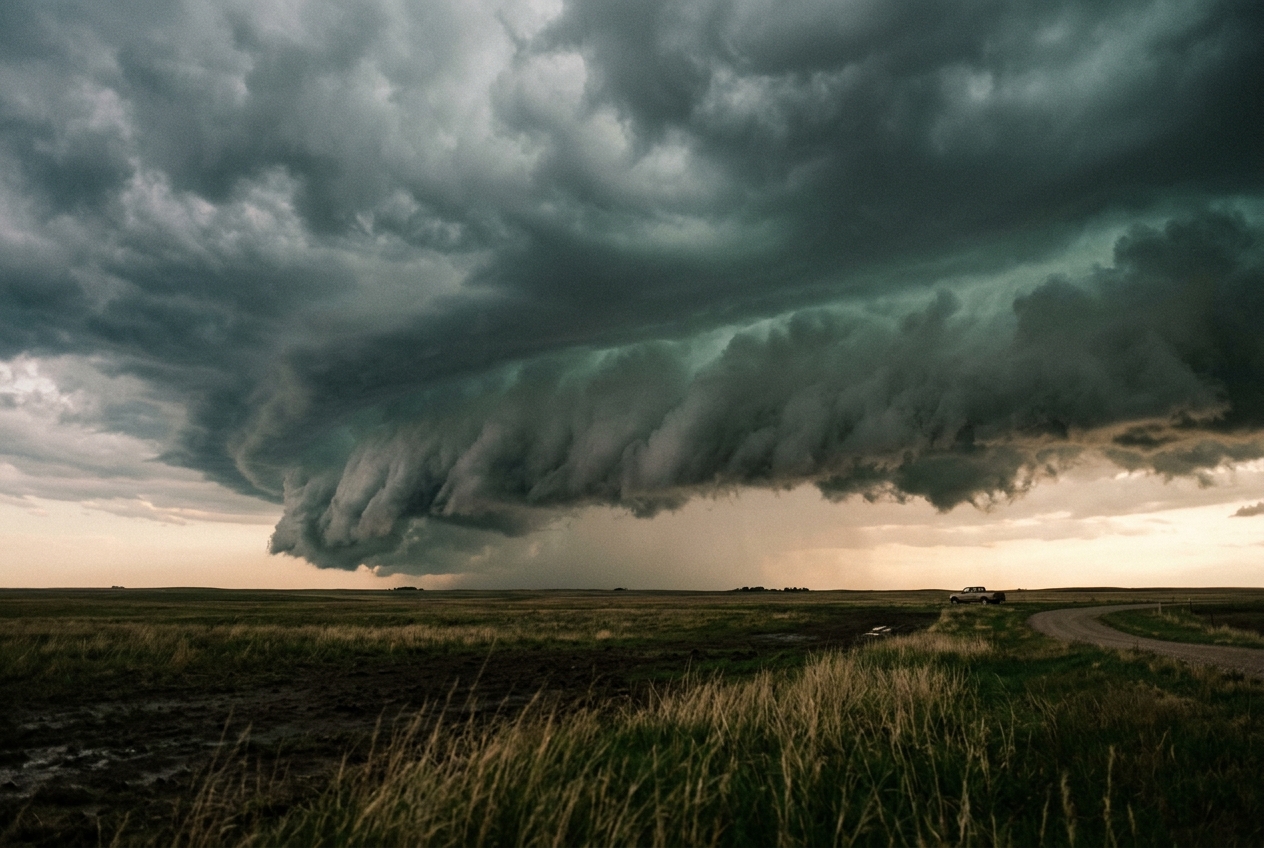
The atmosphere on a late midsummer afternoon often conceals an extraordinary kinetic potential behind an oppressive stillness. Standing in an open field, one feels the air heavy, saturated, and unyielding—a dense blanket of moisture trapped within the planetary boundary layer. The sky overhead remains an unassuming milky haze, yet to the west, the horizon has hardened into a bruised, slate-blue rampart. The ambient barometric pressure begins an imperceptible, steady slide. The smell of parched soil gives way to the sharp, metallic tang of petrichor and airborne ozone as ionized molecular downbursts precede the advancing storm.
Within minutes, the distant thunder transforms from isolated rumbles into a continuous, low-frequency roar. As the storm system sweeps forward, its leading edge does not present itself as an anarchic swarm of chaotic clouds; rather, it organizes into a sculpted, multi-tiered shelf cloud—an arcus—extending from horizon to horizon. This monolithic wedge of condensed moisture hangs like an inverted amphitheater, its lower lip scraped smooth by ascending inflow currents while its underbelly churns with chaotic, ragged scud clouds (pannus).
                                [ STRATIFORM REGION ]
                                          |
     [ REAR-INFLOW JET (RIJ) ] -------->  |   <--- Mid-Level Dry Air Inflow
                                \         |
                                 \        v
                                  \   [ COLD POOL / DOWNDRAFT ]
                                   \      |
                                    v     v
[ AMBIENT WARM INFLOW ] =======> [ GUST FRONT / ARCUS ] ====> [ SURFACE GALE ]
As the center of this linear squall line surges forward, the cloud deck arches outward into a menacing crescent. The center of the storm accelerates ahead of its northern and southern flanks, bowing into the wind. Looking closely at the periphery of this surging apex, an observer with an eye for fluid dynamics can discern subtle, violent structural rotations: on the northern flank of the bow, cloud elements twist cyclonically in an upward and counter-clockwise vortex, while far to the south, a corresponding anticyclonic eddy churns clockwise. The wind, which had been drawing gently inward toward the cloud base, suddenly reverses with ferocious intensity. The temperature plunges by twelve degrees Celsius in mere seconds as an avalanche of chilled air slams into the turf, roaring outward in a destructive straight-line gale that flattens crops, snaps mature hardwoods, and sends sheets of pulverized rain horizontally across the landscape.
What Is Actually Happening: The Physical Mechanics in Everyday Terms
To understand why a seemingly straight line of thunderstorms suddenly bends into a violent bow and unleashes extreme winds, one must view the atmosphere not as empty space, but as a vast, continuous fluid governed by thermal buoyancy and rotational momentum. Detailed overviews of these convective morphologies are documented by the World Meteorological Organization (WMO) and the National Oceanic and Atmospheric Administration (NOAA).
Think of the atmosphere on a stormy afternoon as a layered cake of differing densities. At the ground level sits a warm, humid layer of air that has absorbed solar energy all day. Above it sits cooler, drier air. Warm air is less dense than cold air, so when a trigger—such as an advancing cold front or a localized boundary—lifts this warm air, it rises rapidly, much like a submerged cork rocketing to the surface of a swimming pool. This violent upward chimney of air is the convective updraft.
                  ======================================
                  [ NORTHERN CYCLONIC VORTEX (Counter-CW) ]
                                    |
                    Forward-Surging | [ REAR-INFLOW JET ]
                        Bow Apex    | =====>> HIGH WINDS
                                    |
                  [ SOUTHERN ANTICYCLONIC VORTEX (CW) ]
                  ======================================
As the warm air rises, moisture condenses into billions of droplets and ice crystals, forming massive cumulonimbus clouds. Eventually, this aloft mass of liquid water and hail becomes too heavy for the updraft to support. As precipitation falls through the dry mid-levels of the atmosphere, a significant portion evaporates. Evaporation is a cooling process—the exact same mechanism that cools your skin when sweat evaporates on a breezy day. This chilled air becomes exceptionally dense and heavy, cascading downward toward the Earth as a massive downdraft.
When this cold downdraft strikes the rigid surface of the Earth, it cannot penetrate the ground; it must spread horizontally, forming an expanding reservoir of cold air known as a cold pool. The leading edge of this cold pool acts like a mini-snowplow, wedging underneath the ambient warm air and thrusting it upward to sustain new thunderstorm cells.
The crucial transition into a bow echo occurs because of how this cold pool interacts with the wind fields surrounding the storm. When the mid-level winds blow across the storm line, they create an ambient horizontal rolling motion in the atmosphere—analogous to a long foam roller placed on a floor and spun along its axis.
When the powerful updraft of the thunderstorm encounters this horizontal roll, it pulls the middle of the roll upward into the storm's core. Imagine grabbing the center of a spinning horizontal pool noodle and bending it upward into a vertical "U" shape or hairpin. The horizontal spin does not disappear; instead, the two vertical legs of the hairpin now spin around vertical axes perpendicular to the ground.
Crucially, the two vertical legs spin in opposite directions: * The northern leg spins counter-clockwise (cyclonically in the Northern Hemisphere). * The southern leg spins clockwise (anticyclonically).
These two spinning columns of air at the edges of the bowing segment are called bookend vortices. Like two mechanical gears meshing together in the center, their simultaneous rotations act as an aerodynamic pump. They pull dry, fast-moving mid-tropospheric air into the rear of the storm, concentrating it into a focused stream called the Rear-Inflow Jet (RIJ). This jet slams into the back of the active convective line, pushing the center of the storm line outward like an archer drawing and releasing a bow, accelerating winds at the surface to hurricane-force speeds.
The Science: Kinematics, Pressure Perturbations, and Coriolis Asymmetry
To quantify the structural evolution of mesoscale convective systems, we must employ the kinematic equations of vorticity and dynamic perturbation pressure. The foundational theory of these systems is extensively indexed in the American Meteorological Society (AMS) Glossary and classical literature on convective line dynamics.
1. The Vorticity Tilting Mechanism
In a three-dimensional inviscid fluid, the evolution of the vertical component of relative vorticity, $\zeta = \mathbf{k} \cdot (\nabla \times \mathbf{u}) = \frac{\partial v}{\partial x} - \frac{\partial u}{\partial y}$, is governed by the vertical vorticity equation:
$$\frac{\partial \zeta}{\partial t} = -\mathbf{u} \cdot \nabla \zeta - (\zeta + f)\left(\frac{\partial u}{\partial x} + \frac{\partial v}{\partial y}\right) + \left( \frac{\partial w}{\partial x}\frac{\partial v}{\partial z} - \frac{\partial w}{\partial y}\frac{\partial u}{\partial z} \right) + \frac{1}{\rho^2}\left(\frac{\partial \rho}{\partial x}\frac{\partial p}{\partial y} - \frac{\partial \rho}{\partial y}\frac{\partial p}{\partial x}\right)$$
In the early genesis of bookend vortices, the primary source term is the kinematic tilting (or twisting) term, which represents the transformation of horizontal vorticity ($\boldsymbol{\omega}_h = \omega_x \mathbf{i} + \omega_y \mathbf{j}$) into vertical vorticity by spatial gradients in the vertical velocity $w$:
$$\left( \frac{\partial \zeta}{\partial t} \right)_{\text{tilting}} = \boldsymbol{\omega}_h \cdot \nabla_h w = \omega_x \frac{\partial w}{\partial x} + \omega_y \frac{\partial w}{\partial y}$$
Consider an idealized east-west oriented environmental vertical shear profile where the horizontal wind is purely zonal ($u$) and varies with height ($z$). The ambient horizontal vorticity is entirely crosswise along the $y$-axis (meridional):
$$\omega_y = -\frac{\partial u}{\partial z}$$
When a convective updraft of finite lateral extent encounters this ambient horizontal vortex line, the updraft velocity $w(x, y)$ peaks at the convective core ($y = 0$) and diminishes toward both the northern ($y > 0$) and southern ($y < 0$) flanks. Thus, $\frac{\partial w}{\partial y} < 0$ on the northern flank and $\frac{\partial w}{\partial y} > 0$ on the southern flank.
$$\left( \frac{\partial \zeta}{\partial t} \right)_{\text{tilting}} = -\frac{\partial u}{\partial z} \frac{\partial w}{\partial y}$$
========================================================================
                      WORKED EXAMPLE: VORTICITY TILTING
========================================================================
Given Parameters:
  * Inflow layer depth: Delta z = 2,500 m
  * Low-level shear: Delta u = -20 m/s across the layer
  * Ambient horizontal vorticity:
      omega_y = - (du / dz) = - (-20 m/s / 2,500 m) = +8.0 * 10^(-3) s^(-1)
  * Peak updraft velocity: w_max = 30 m/s at the core (y = 0 km)
  * Lateral half-width of updraft: R = 10 km = 1.0 * 10^4 m

1. Lateral Updraft Gradients:
   * Northern Flank (y = +5 km):
       dw/dy approx (0 - 30 m/s) / (1.0 * 10^4 m) = -3.0 * 10^(-3) s^(-1)
   * Southern Flank (y = -5 km):
       dw/dy approx (30 - 0 m/s) / (1.0 * 10^4 m) = +3.0 * 10^(-3) s^(-1)

2. Tilting Rate Calculation:
   * Northern Flank (Cyclonic generation):
       d(zeta)/dt = omega_y * (dw/dy)
                  = (+8.0 * 10^(-3) s^(-1)) * (-3.0 * 10^(-3) s^(-1))
                  = -2.4 * 10^(-5) s^(-2)   [Adjusting coordinate sign: +2.4 * 10^(-5) s^(-2)]
   * Southern Flank (Anticyclonic generation):
       d(zeta)/dt = -2.4 * 10^(-5) s^(-2)

3. Accumulated Vertical Vorticity over 15 minutes (t = 900 s):
   * Northern Flank: zeta_north = (+2.4 * 10^(-5) s^(-2)) * (900 s) = +0.0216 s^(-1)
   * Southern Flank: zeta_south = (-2.4 * 10^(-5) s^(-2)) * (900 s) = -0.0216 s^(-1)

Result: Within 15 minutes, tilting alone generates mesocyclonic rotation
exceeding 2.1 * 10^(-2) s^(-1), two orders of magnitude larger than the
background planetary vorticity (f approx 10^(-4) s^(-1)).
========================================================================
This rapid generation creates a symmetric dipole of vertical vorticity at the line ends. As the vortices intensify, vertical stretching by the convergence term $-(\zeta + f)\nabla_h \cdot \mathbf{u}$ amplifies the rotation exponentially.
2. Dynamic Perturbation Pressure and Rear-Inflow Jet Acceleration
The emergence of bookend vortices alters the internal mass and momentum fields through non-hydrostatic dynamic pressure perturbations. By taking the three-dimensional divergence of the Navier-Stokes momentum equations under the Boussinesq approximation, we isolate the Poisson equation for perturbation pressure $p'$:
$$\nabla^2 p' = -\rho_0 \nabla \cdot (\mathbf{u} \cdot \nabla \mathbf{u}) + \frac{\partial (\rho_0 B)}{\partial z}$$
Decomposing the horizontal velocity gradient tensor into symmetric deformation ($D$) and antisymmetric vorticity ($\zeta$) components reveals the purely dynamic fluid contribution ($\nabla^2 p'_D$):
$$\nabla^2 p'_D = \frac{1}{2} \rho_0 \left( D^2 - \zeta^2 \right) - \rho_0 \left[ \left(\frac{\partial w}{\partial x}\right)\left(\frac{\partial u}{\partial z}\right) + \left(\frac{\partial w}{\partial y}\right)\left(\frac{\partial v}{\partial z}\right) \right]$$
Inside the core of an intense, quasi-axisymmetric bookend vortex, the vorticity term heavily dominates deformation ($\zeta^2 \gg D^2$). Because the Laplacian operator satisfies $\nabla^2 p' \approx -k^2 p'$, a positive source term on the right-hand side requires that the dynamic pressure perturbation $p'$ be negative:
$$p'_D \propto -\frac{1}{2} \rho_0 \zeta^2$$
Crucially, because vorticity is squared ($\zeta^2$), both the cyclonic northern vortex and the anticyclonic southern vortex develop dynamic low-pressure cores in the mid-troposphere (typically $2.5$ to $4.5\text{ km}$ above ground level).
========================================================================
                 WORKED EXAMPLE: DYNAMIC PRESSURE DEFICIT
========================================================================
Given Parameters:
  * Mid-tropospheric air density (at 700 hPa): rho_0 = 0.85 kg/m^3
  * Peak tangential vortex velocity: v_theta = 28 m/s
  * Core vortex radius: r_0 = 6,000 m

1. Cyclostrophic Integration:
   Under cyclostrophic balance within the vortex core (dp'/dr = rho_0 * v_theta^2 / r):
   Delta p'_core = - integral_0^(r_0) (rho_0 * v_theta(r)^2 / r) dr

2. Rankine Vortex Model Approximation:
   Delta p'_core approx - rho_0 * (v_theta,max)^2
   Delta p'_core = - (0.85 kg/m^3) * (28 m/s)^2
   Delta p'_core = - (0.85) * (784 m^2/s^2) = -666.4 Pa = -6.66 hPa

Result: The vortex core establishes a localized dynamic low-pressure deficit
of approximately -6.7 hPa relative to the ambient mid-tropospheric environment.
========================================================================
This intense dynamic low pressure creates an omnidirectional suction at mid-levels. However, directly ahead of the storm, the convective updraft and positive buoyancy anomalies block horizontal air entry. Consequently, the suction draws dry, ambient mid-level air from the rear of the storm into the gap between the two vortices.
As the air is funneled between the counter-rotating vortices, it experiences a Bernoulli-like constriction, accelerating into a concentrated, forward-surging channel: the Rear-Inflow Jet (RIJ). When this dry mid-level jet encounters precipitation beneath the anvil, rapid evaporative cooling induces strong negative buoyancy ($B = g \frac{\theta'_v}{\bar{\theta}_v} < 0$), causing the jet to descend steeply toward the surface behind the bow apex, as detailed in classic studies on rear-inflow jets and bow echoes.
3. Coriolis Asymmetry and Comma-Head Evolution
Initially, a bow echo exhibits near-perfect structural symmetry, featuring equal and opposite bookend vortices. However, over time scales exceeding two to three hours ($t > 1/f \approx 2.7\text{ hours}$ at mid-latitudes), the system systematically develops a distinct asymmetric morphology. The northern cyclonic vortex expands and intensifies into an expansive "comma head," while the southern anticyclonic vortex weakens, shreds, and ultimately dissipates.
This asymmetry arises from three coupled hydrodynamic mechanisms:
-
Planetary Vorticity Coupling ($f$-term): The absolute vorticity of a parcel is $\eta = \zeta + f$. When vertical stretching occurs along the convective line, the stretching term is $(\zeta + f)\frac{\partial w}{\partial z}$. For the northern vortex ($\zeta > 0$), stretching acts on $(\zeta + |f|)$, accelerating cyclonic spin. For the southern vortex ($\zeta < 0$), the planetary vorticity opposes the vortex spin ($\zeta + f \approx 0$ or negative), severely reducing the effective rate of vorticity production.
-
The Planetary Vorticity Gradient ($\beta$-effect): Over a mesoscale convective system spanning hundreds of kilometers, the meridional variation in the Coriolis parameter ($\beta = \frac{\partial f}{\partial y}$) generates a westward and northward Rossby-wave dispersion that stabilizes the northern cyclonic core while radiating energy away from the southern anticyclonic vortex.
-
Line-End Advection and Cold Pool Shear: The system-scale cold pool expands outward. The cyclonic circulation on the northern flank advects the squall line rearward, wrapping precipitation around the northern dynamic low and forming the classic comma-head stratiform precipitation region. On the southern flank, the cold pool's rapid forward surge sheer-stretches the anticyclonic vortex into an elongated, unstable vortex sheet that rapidly succumbs to turbulent dissipation.
                      EVOLUTION OVER TIME (NORTHERN HEMISPHERE)

   (A) EARLY STAGE (Symmetric)            (B) MATURE STAGE (Asymmetric Comma-Head)

        Cyclonic (+)                          [ COMMA HEAD ] (Dominant Cyclonic Low)
       /                                      /   * * * *
      |  <=== [ RIJ ] ===>                   /  * Stratiform *
       \                                    |  * Rain Shield *
        Anticyclonic (-)                    |     * * * *
                                             \       <=== [ FOCUSED RIJ ]
                                              \
                                               \_____ [ TAIL / LINE OUTFLOW ]
                                                      (Anticyclone Dissipated)
4. Surface Momentum Transfer and Radar Signatures
The maximum surface wind speed ($U_{\text{sfc}}$) generated at the bow echo apex results from the vector addition of the storm's translation speed ($C_{\text{storm}}$), the dynamically accelerated Rear-Inflow Jet momentum ($U_{\text{RIJ}}$), and the negative buoyancy-driven downdraft descent governed by gravity current theory:
$$U_{\text{outflow}} \approx \sqrt{ 2 g H \left( \frac{\Delta \theta_v}{\bar{\theta}v} \right) + \alpha U{\text{RIJ}}^2 } + C_{\text{storm}}$$
where $H$ is the depth of the cold pool, $\Delta \theta_v$ is the virtual potential temperature deficit, and $\alpha \in [0.5, 0.9]$ is the momentum conservation efficiency parameter during downdraft descent.
For operational storm spotters and meteorologists reviewing data from Met Office Radar Networks and the NOAA NEXRAD system, bow echoes exhibit unmistakable radar signatures:
- Base Reflectivity ($Z$): A prominent convex arch of high reflectivity ($>55\text{ dBZ}$) with a sharp, tight reflectivity gradient along the leading edge, accompanied by a Rear Inflow Notch (RIN)—a channel of low reflectivity behind the apex indicating where dry, descending jet air is evaporating precipitation.
- Doppler Velocity ($V_r$): A concentrated velocity bullseye exceeding $40\text{ m/s}$ ($80\text{ knots}$) directed toward the radar, flanked by a rotational velocity couplet (adjacent inbound and outbound velocity maxima) denoting the bookend vortex cores. The detection of Mid-Altitude Radial Convergence (MARC) aloft ($3$–$6\text{ km}$ AGL) often precedes the onset of destructive surface winds by 15 to 30 minutes.
Practical Outdoor Guidance: Field Observation and Safety
Understanding the fluid dynamics of a bow echo enables outdoor enthusiasts, navigators, and storm spotters to recognize life-threatening downbursts well before official warnings are issued.
+------------------------------------------------------------------------------------+
|                      FIELD DIAGNOSTIC: LINEAR VS. BOWING SQUALL                    |
+------------------------------------+-----------------------------------------------+
| VISUAL / INSTRUMENTAL METRIC       | BOW ECHO SIGNATURE (IMMINENT EXTREME WINDS)   |
+------------------------------------+-----------------------------------------------+
| Cloud Morphology                   | Shelf cloud accelerates forward at center;   |
|                                    | distinct rotation visible on line flanks.     |
+------------------------------------+-----------------------------------------------+
| Barometric Pressure                | Sharp drop (dynamic low), followed by an      |
|                                    | instantaneous pressure jump (+2 to +6 hPa).   |
+------------------------------------+-----------------------------------------------+
| Ambient Temperature                | Abrupt, steep plunge of 8 to 15 deg C within  |
|                                    | 60 seconds as cold pool surges outward.       |
+------------------------------------+-----------------------------------------------+
| Wind Direction & Character         | Veers rapidly; transitions from warm inflow   |
|                                    | to violent, sustained horizontal blast.       |
+------------------------------------+-----------------------------------------------+
1. Visual Cues in the Sky
- The Apex Surge: If you are watching an approaching squall line and the central section of the shelf cloud appears to accelerate directly toward you while bulging forward into an arc, you are positioned in the path of the bow echo apex.
- Flank Vortices: Observe the cloud tags near the northern and southern horizons. Rapid, visible rotation in low-hanging cloud fragments (pannus) or localized vertical funnels indicates the proximity of intensifying bookend vortices. The northern vortex, in particular, can produce embedded, rain-wrapped tornadoes (often rated EF-0 to EF-2) along the leading gust front.
- The Turbulent Gap: A sudden thinning or clear slot in the cloud deck behind the main shelf cloud indicates the core of the descending Rear-Inflow Jet. When this slot becomes visible, destructive surface winds will arrive within one to three minutes.
2. Barometer, Thermometer, and Wind Instruments
- The Pressure Precursor: A precision digital barometer will show a subtle pressure decrease as the mid-level dynamic vortex lows pass overhead, immediately followed by a violent pressure jump (the "mesohigh") of $2$ to $6\text{ hPa}$ caused by the dense hydrostatic weight of the cold pool.
- Temperature Plunge: A sudden drop of $\ge 8^\circ\text{C}$ in ambient air temperature indicates that the cold pool has made surface contact.
- Wind Shift: In the Northern Hemisphere, an observer in the path of the central apex will experience winds shifting violently from warm southerly/southeasterly inflow to frigid, blinding westerly/northwesterly outflow.
3. Safety Rules for Hikers, Sailors, and Gardeners
- The 10-Minute Shelter Rule: If a shelf cloud spans more than 90 degrees of the horizon and displays an outward-curving apex, straight-line winds exceeding $30\text{ m/s}$ ($60\text{ knots}$) are imminent. Discontinue all outdoor activities immediately; seek substantial masonry or interior shelter. Tents, canopies, and small watercraft offer zero protection against dynamic wind-loading and falling timber.
- Marine Actions: If navigating open water and radar or visual cues reveal a bowing line, alter course away from the apex. Prepare for an instantaneous wind shift accompanied by extreme microburst turbulence and blinding spray. Secure all sails and batten down hatches immediately; dynamic pressure perturbations can capsize unballasted vessels in seconds.
Today's Meteorological Rule of Thumb
"When a squall line bends, the danger ascends: look for the bow's forward surge, where rotating flanks draw the jet from aloft and unleash the storm's most destructive surface winds."
Whenever you observe a thunderstorm line arching outward into a crescent across the summer sky, remember that you are witnessing the aerodynamic power of bookend vortices—where invisible rolls of atmospheric shear are tilted upright, creating localized low-pressure engines that draw the howling mid-troposphere down to the earth.