Asperitas Cloud Dynamics & Gravity Wave Interference: How Shear-Driven Wave Modulation and Stable Boundary Layers Sculpt Undulating Sky Seas
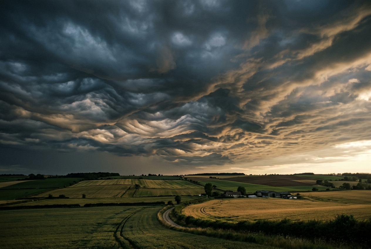
The transition begins not with a sudden crack of thunder, but with an eerie, suffocating stillness. Standing upon an open expanse of prairie in the late afternoon, the heat of the day feels trapped against the earth, thick with humidity and smelling faintly of dried dust, crushed grass, and the sharp, metallic tang of ionized air drifting from an unseen storm dozens of miles to the west. The wind, which had been rustling the treetops in fitful gusts all afternoon, abruptly drops to absolute zero. The hair on your forearms prickles as the ambient barometric pressure begins a rhythmic, subtle shudder—an imperceptible pulsing in the eardrums that seasoned storm chasers recognize as the passing of a deep atmospheric wave.
       WARM, SHEARING AIR MASS (Upper Layer)  ----> U(z)
~~~~~~~~~~~~~~~~~~~~~~~~~~~~~~~~~~~~~~~~~~~~~~~~~~~~~~~~~~~~~~~ Inversion Layer
  _ . - - . _        _ . - - . _        _ . - - . _
 (  Asperitas)      (  Wave Base)      ( Undulations)   <--- Cloud Underside
  ` ' - - ' `        ` ' - - ' `        ` ' - - ' `
~~~~~~~~~~~~~~~~~~~~~~~~~~~~~~~~~~~~~~~~~~~~~~~~~~~~~~~~~~~~~~~
       COLD, DENSE BOUNDARY LAYER (Stable Air) <---- Stable Sub-layer
======================= GROUND LEVEL ===========================
Then you look directly overhead. The familiar flat, gray ceiling of stratiform cloud has vanished, replaced by an unsettling, three-dimensional spectacle that defies terrestrial intuition. The underside of the cloud deck appears as an agitated, rolling sea viewed from the seabed looking upward. Great, sculpted troughs and crests roll across the sky in chaotic patterns, carved with fine, sinuous ribbons of dark slate, bruised ochre, and blinding pearl. It looks violently turbulent, resembling a churning oceanic tempest poised to unleash catastrophic downpours and destructive squalls.
Yet, as you stand transfixed, not a single drop of rain falls. The air at ground level remains dead calm and dry. There is no violent downdraft striking your face, no hail pelting the dirt. The sky is behaving like a turbulent fluid interface suspended two thousand meters above your head, completely decoupled from the quiet world below. This mesmerizing, paradoxical phenomenon is asperitas—one of the newest and dynamically intricate cloud classifications in modern meteorology.
2. What Is Actually Happening: The Fluid Mechanics of an Inverted Sea
To understand why the sky can resemble an agitated ocean while the earth beneath remains untouched, we must discard the notion of air as empty space and view the troposphere for what it truly is: a vast, layered, and restless ocean of fluid gas.
  Wave Ray 1 ----\      /---- Wave Ray 2 (Interfering Wave Fronts)
                  \    /
                   \  /
~~~~~~~~~~~~~~~~~~~~><~~~~~~~~~~~~~~~~~~~~ Density Interface (Inversion)
                   /  \
                  /    \
  Reflected Wave <      > Reflected Wave  ===> Localized Chaotic Pockets
The Atmosphere as a Layered Cake
Think of the lower atmosphere on such an afternoon as a multi-layered cake. Near the ground lies a cold, dense, and moisture-laden layer of air, often left behind by the rainy outflow of a decaying thunderstorm or an approaching shallow cold front. Above this dense layer sits a much warmer, lighter air mass sliding rapidly in a different direction.
In meteorology, when warm air sits atop cold air, the condition is termed a temperature inversion. Under normal conditions, warm air rises because it is buoyant; but when warm air already rests above cold air, the atmosphere is dynamically stable. The heavy air is content to remain below, and the light air remains above.
When an external disturbance—such as the cold density current from a distant squall line—rams into this stable, layered structure, it acts like a massive stone hurled into a placid pond. It forces the boundary between the cold and warm layers to buckle and oscillate.
The Buoyant Restoring Force
When a parcel of air within the cold lower layer is shoved upward into the warmer layer by a passing disturbance, it finds itself surrounded by air that is lighter and warmer than itself. Just like a submerged cork released at the bottom of a bucket of water, the displaced parcel is negatively buoyant: gravity pulls it back down. However, as it sinks under momentum, it overshoots its original equilibrium position and plunges deep into the cold layer. Now, being surrounded by denser air, it is pushed back upward.
This back-and-forth oscillation between gravity pulling the parcel down and positive buoyancy pushing it back up is known as an internal gravity wave (not to be confused with relativistic gravitational waves of astrophysics). When these waves propagate along the sharp boundary between the two air layers, they displace the cloud base upward and downward, creating crests and troughs.
From Undulatus to Asperitas: The Role of Interference
Parallel wave clouds are relatively common in the atmosphere; meteorologists classify them as stratocumulus undulatus. Why, then, does asperitas look so dramatically different—chaotic, lumpy, and crisscrossed rather than orderly and parallel?
The difference lies in wave interference and vertical wind shear. Asperitas forms in environments where multiple wave trains travel in different directions across the same fluid boundary. When two or more gravity wave packets collide at angles, their peaks and troughs superimpose: - Where two crests meet, the cloud base is pushed sharply upward into a dramatic ridge. - Where two troughs meet, the cloud base sinks toward the ground in a smooth, rounded hollow. - Where a crest meets a trough, the motions cancel out.
The result is a complex, three-dimensional interference pattern—an atmospheric standing-wave field that looks identical to the chaotic, crossing wave chop observed when ocean swells bounce off a harbor sea wall.
History and Official Recognition
For centuries, classical meteorologists largely overlooked these chaotic underbellies, treating them as aberrant forms of mammatus or degraded undulatus. However, in the mid-2000s, citizen scientists from the Cloud Appreciation Society began documenting widespread photographic evidence of these ominous, wave-swept cloudscapes.
Recognizing that the dynamics driving these formations were distinct from existing genera, the meteorological community initiated extensive lidar, radar, and satellite investigations. In 2017, the World Meteorological Organization (WMO) International Cloud Atlas officially introduced asperitas (derived from the Latin for "roughness") as a new supplementary cloud feature—the first major cloud addition to the international atlas in over half a century.
+-----------------------------------------------------------------------------------+
|                        ASPERITAS vs. MAMMATUS vs. UNDULATUS                       |
+----------------------+--------------------+--------------------+------------------+
| Feature              | Primary Dynamic    | Morphological Form | Precipitation?   |
+----------------------+--------------------+--------------------+------------------+
| Asperitas            | Trapped gravity    | Chaotic, sculpted  | Rare at surface; |
|                      | wave interference  | undulating troughs | confined aloft   |
+----------------------+--------------------+--------------------+------------------+
| Mammatus             | Evaporative        | Hanging, pendulous | Virga common;    |
|                      | negative buoyancy  | cellular pouches   | downdraft-driven |
+----------------------+--------------------+--------------------+------------------+
| Stratocumulus        | Linear, uni-direc- | Orderly, parallel  | Light drizzle    |
| undulatus            | tional wind shear  | transverse rolls   | possible         |
+----------------------+--------------------+--------------------+------------------+
3. The Science: Fluid Dynamics and Trapped Gravity Waves
For those who wish to understand the quantitative mechanics governing these formations, we must examine the exact mathematical machinery that sustains trapped atmospheric gravity waves and sculpts the visible cloud envelope.
1. The Brunt-Väisälä Frequency ($N$)
The fundamental measure of an atmospheric layer's capacity to sustain gravity waves is the Brunt-Väisälä frequency ($N$), also known as the static stability parameter.
Plain English Prediction
$N$ predicts how rapidly a displaced parcel of air will bob up and down when perturbed inside a stable layer. If $N^2 > 0$, the atmosphere acts like a mechanical spring: the higher the value of $N$, the stiffer the spring, meaning displaced parcels will oscillate rapidly with short wave periods. If $N^2 \le 0$, the atmosphere is statically unstable, and parcels will simply rise or sink continuously without oscillating, destroying any wave structure.
The Governing Equation
In a dry or unsaturated atmosphere, the Brunt-Väisälä frequency is defined as:
$$N = \sqrt{\frac{g}{\theta_0} \frac{\partial \theta}{\partial z}}$$
Where: - $g$ is the acceleration due to gravity ($9.81\text{ m/s}^2$). - $\theta_0$ is the mean background potential temperature of the layer in Kelvin ($\text{K}$). - $\frac{\partial \theta}{\partial z}$ is the vertical gradient of potential temperature (the lapse rate of potential temperature across altitude $z$, in $\text{K/m}$).
Worked Mathematical Example
Consider an atmospheric sounding taken near the formation of an asperitas cloud deck: - Surface to $1{,}000\text{ m}$: Mean potential temperature $\theta_0 = 295\text{ K}$. - An inversion layer extends from $z_1 = 1{,}000\text{ m}$ to $z_2 = 1{,}300\text{ m}$ ($\Delta z = 300\text{ m}$). - Across this inversion layer, potential temperature increases from $\theta(z_1) = 295\text{ K}$ to $\theta(z_2) = 301\text{ K}$ ($\Delta \theta = 6\text{ K}$).
We calculate the potential temperature gradient:
$$\frac{\partial \theta}{\partial z} \approx \frac{\Delta \theta}{\Delta z} = \frac{6\text{ K}}{300\text{ m}} = 0.02\text{ K/m}$$
Substituting these values into the Brunt-Väisälä relation:
$$N = \sqrt{\frac{9.81\text{ m/s}^2}{295\text{ K}} \times 0.02\text{ K/m}} = \sqrt{3.325 \times 10^{-2} \times 0.02} = \sqrt{6.651 \times 10^{-4}}\text{ s}^{-1} \approx 0.0258\text{ s}^{-1}$$
To find the natural period of oscillation ($\tau$) for an air parcel displaced within this layer:
$$\tau = \frac{2\pi}{N} = \frac{2 \times 3.14159}{0.0258\text{ s}^{-1}} \approx 243.5\text{ seconds} \approx 4.06\text{ minutes}$$
An oscillation period of approximately four minutes matches the observed physical displacement timescale of asperitas wave crests viewed from the ground, confirming that the cloud-base geometry is governed directly by buoyant restoring forces.
Non-Hydrostatic Vertical Velocity and Optical Depth Modulation
As these waves ripple across the cloud layer, they introduce localized, non-hydrostatic vertical velocity perturbations ($w'$), typically measured by Doppler lidar in the range of:
$$w' \sim \pm 1.0\text{ to } 2.5\text{ m/s}$$
While a vertical velocity of $2\text{ m/s}$ is insufficient to tear the cloud apart or ignite deep convective updrafts, it has a profound effect on the cloud's microphysics and visual appearance.
As moist air is forced upward in a wave crest ($w' > 0$), adiabatic cooling causes water vapor to condense rapidly, increasing the droplet number concentration and thickening the optical depth ($\tau_{opt}$). Conversely, in the wave trough ($w' < 0$), adiabatic warming evaporates cloud droplets, thinning the cloud base and allowing ambient daylight from the upper troposphere to penetrate the layer.
Sunlight / Ambient Diffuse Light (Above)
       |           |           |           |
       v           v           v           v
  =========== CREST ===========     === TROUGH ===     =========== CREST ===========
   Dense Condensation: High τ        Evaporation: Low τ   Dense Condensation: High τ
   [ Dark / Opaque Underbelly ]      [ Bright Illumination] [ Dark / Opaque Underbelly ]
This stark contrast in optical thickness across adjacent parcels produces the dramatic, high-contrast illumination characteristic of asperitas: shadowed, dark-slate hollows framed by luminous, sunlit wave peaks.
2. Wave Trapping: The Scorer Parameter ($l^2$)
For asperitas to develop its pronounced relief, gravity wave energy must not radiate freely upward into the stratosphere; it must be trapped within a narrow horizontal channel near the cloud base, acting as an atmospheric waveguide. The physics of this trapping is quantified by the Scorer parameter ($l^2$).
Plain English Prediction
The Scorer parameter evaluates whether a given atmospheric layer will allow a gravity wave to pass through it vertically or reflect it back downward. If the lower layer has a high Scorer value and the upper layer has a low Scorer value, gravity waves propagating upward hit the upper layer and bounce back down. Trapped between the rigid earth below and the reflective layer above, the waves interfere with one another and maintain their sharp, sculpted amplitudes over extended distances.
The Governing Equation
Derived from the Taylor-Goldstein equation for stratified, sheared fluid flows (see the American Meteorological Society Glossary and foundational texts via Wikipedia: Gravity Waves), the Scorer parameter $l^2(z)$ is given by:
$$l^2(z) = \frac{N^2(z)}{U^2(z)} - \frac{1}{U(z)}\frac{d^2U}{dz^2}$$
Where: - $N(z)$ is the Brunt-Väisälä frequency at height $z$. - $U(z)$ is the mean horizontal wind velocity profile parallel to the wave vector. - $\frac{d^2U}{dz^2}$ is the vertical curvature of the wind profile (shear curvature).
For a wave with horizontal wavenumber $k_x = \frac{2\pi}{\lambda_x}$ (where $\lambda_x$ is the horizontal wavelength): - If $k_x^2 < l^2(z)$, the wave propagates vertically ($m^2 > 0$). - If $k_x^2 > l^2(z)$, the vertical wavenumber $m$ becomes imaginary ($m^2 < 0$), and the wave energy decays exponentially with height (evanescence/total internal reflection).
Worked Mathematical Example
Let us evaluate whether an asperitas wave of wavelength $\lambda_x = 2{,}000\text{ m}$ ($2\text{ km}$) will be trapped within a boundary layer capped by a strong shear zone.
First, calculate the horizontal wavenumber $k_x$:
$$k_x = \frac{2\pi}{2{,}000\text{ m}} = \frac{6.28318}{2{,}000} \approx 3.14 \times 10^{-3}\text{ m}^{-1} \implies k_x^2 \approx 9.87 \times 10^{-6}\text{ m}^{-2}$$
Layer 1 (The Cloud Base, $z = 1{,}000\text{ m}$): - Strong stability: $N_1 = 0.025\text{ s}^{-1}$. - Light ambient wind: $U_1 = 5\text{ m/s}$. - Neglect wind curvature ($\frac{d^2U}{dz^2} \approx 0$):
$$l_1^2 = \frac{N_1^2}{U_1^2} = \frac{(0.025)^2}{5^2} = \frac{6.25 \times 10^{-4}}{25} = 2.50 \times 10^{-5}\text{ m}^{-2}$$
Layer 2 (The Shearing Cap Aloft, $z = 2{,}500\text{ m}$): - Moderate stability: $N_2 = 0.010\text{ s}^{-1}$. - Strong jet stream wind: $U_2 = 25\text{ m/s}$:
$$l_2^2 = \frac{N_2^2}{U_2^2} = \frac{(0.010)^2}{25^2} = \frac{1.00 \times 10^{-4}}{625} = 1.60 \times 10^{-7}\text{ m}^{-2}$$
Comparison: Comparing the wave's horizontal wavenumber $k_x^2$ to the Scorer values across both layers:
$$l_2^2\ (1.60 \times 10^{-7}) < k_x^2\ (9.87 \times 10^{-6}) < l_1^2\ (2.50 \times 10^{-5})$$
Because $k_x^2 < l_1^2$, the wave propagates freely inside Layer 1. But because $k_x^2 > l_2^2$, the wave cannot propagate into Layer 2; it is totally internally reflected at the interface.
The energy is trapped inside the lower cloud deck, bouncing repeatedly between the surface and the upper shear layer. When multiple reflected waves crossing at oblique angles interfere constructively, they sculpt the distinctive, enduring troughs and peaks of the asperitas underbelly.
4. Practical Outdoor Guidance: The Observer's Field Manual
Asperitas is among the most dramatic visual phenomena in the natural world, but witnessing it requires understanding the environmental conditions under which it thrives.
       TYPICAL ASPERITAS MESOSCALE PROFILE
  Altitude
     ^
  4km|     [ Warm, Dry Downstream Flow / High Shear ]
     |     -------------------------------------------  Upper Inversion Boundary (Wave Reflection)
  2km|     [ Moist, Stratified Asperitas Cloud Deck ]
     |     ~~~~~~~~~~~~~~~~~~~~~~~~~~~~~~~~~~~~~~~~~~~  Cloud Base Wave Interference Zone
  1km|     [ Cold Stable Density Current / Outflow ]
  0km+================================================> Distance
     Ground Station: Microbarograph Ripples (±0.8 hPa), Calm Surface Winds
What to Look for in the Sky
- The Inverted Ocean Underside: Look for an undulating, chaotic cloud base without distinct individual cloud elements. Unlike cumulus clouds, which grow upward from flat bases, asperitas exhibits deep downward and upward folds carved into an otherwise uniform stratocumulus or altocumulus sheet.
- Backlit Optical Contrast: The most stunning displays occur during the early morning or late afternoon when low-angle sunlight enters beneath the cloud deck. The sun illuminates the descending troughs and ascending ridges from below, casting complex shadows and creating dramatic golden, amber, or slate-green hues.
- Absence of Immediate Precipitation: Even though the sky looks menacing and dark, precipitation rarely reaches the ground directly beneath the wave field. Any rain falling from the upper deck typically evaporates as virga within the stable sub-cloud layer.
What Instrument Readings to Watch
For observers equipped with basic home weather stations, barometers, or smartphones with barometric sensors:
- Barometer (Rapid Micro-Oscillations): Watch for high-frequency, low-amplitude pressure ripples. While the passage of a standard cold front causes a single sharp pressure jump, an active gravity wave duct induces rapid pressure fluctuations of $0.3\text{ to } 1.5\text{ hPa}$ over periods of 5 to 15 minutes.
- Thermometer (Boundary Layer Decoupling): Surface temperatures will typically be significantly cooler than the air mass preceding the storm, confirming the presence of a dense, cold surface layer beneath a warm inversion.
- Anemometer & Wind Vane: Look for a marked directional decoupling between surface winds and cloud motion. Surface winds will often be calm or blowing gently from the east/northeast, while the asperitas wave crests race rapidly from the west or southwest, revealing strong directional and speed shear aloft.
Safety Implications for Aviation and Outdoor Activities
While asperitas is entirely benign for observers on the ground, it presents a significant hazard for general aviation and low-altitude flight operations. The boundary layer harboring these trapped gravity waves is characterized by severe low-level wind shear (LLWS) and intense clear-air turbulence. Aircraft descending through the inversion layer will experience rapid fluctuations in airspeed and vertical lift as they traverse the alternating updraft and downdraft cores ($w' \sim \pm 2\text{ m/s}$).
5. Summary and Comparison with Related Cloud Formations
To solidify your field identification skills, keep in mind how asperitas relates dynamically to other classic cloud structures detailed by the Royal Meteorological Society:
Today's Meteorological Rule of Thumb
"A roaring sea aloft with calm below signals waves trapped where the air won't blow: when the sky churns like water but leaves the ground dry, look for the shearing inversion that ripples the sky."
Whenever you observe an agitated, sea-like cloud underbelly that threatens a deluge but yields only silence and calm, remember that you are standing at the bottom of an atmospheric ocean, watching the invisible architecture of gravity waves bouncing along an overhead boundary of temperature and wind.