Von Kármán Vortex Streets & Island Wake Dynamics: How Isolated Topography and Reynolds Number Regimes Carve Mesoscale Atmospheric Eddies
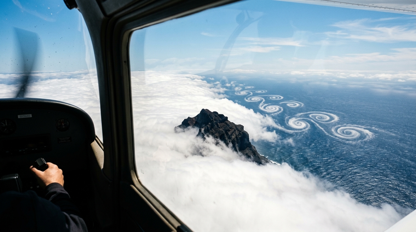
How isolated volcanic peaks carve vast, rotating spiral chains into the subtropical marine cloud deck—and what this reveals about the hidden fluid dynamics of our atmosphere.
1. Opening Scene: The Edge of the Cloud Sea
Stand at dawn on the volcanic spine of Pico do Arieiro on Madeira, nearly two thousand meters above the Atlantic, and the world below ceases to resemble land and water. Instead, a blindingly white, solid-looking plain of marine stratocumulus clouds stretches unbroken toward the northern horizon. The air up here is crisp, desiccated, and biting; it smells faintly of cold basalt and dry lichen. Above your head, the sky is an unblemished, deep sapphire.
Yet, step to the southern lip of the ridge, and the placid white desert suddenly fractures.
Downwind of the island’s central massif, the cloud deck does not simply part like water around a ship's bow. It twists, tears, and reorganizes itself into an immense, interlocking parade of giant celestial whirlpools. To your left, a vast spiral of cloud rotates slowly counterclockwise, carving out a dark, cloud-free eye twenty miles across that exposes the deep indigo of the ocean below. A few miles further downstream and to the right, a second vortex forms, spinning clockwise in perfect opposition.
Wind Direction (North to South: ===>)

[ Isolated Island Peak ]
                         /     \
    ====================        ==================== (Incoming Stratocumulus Deck)
                         \     /
       ( + ) Cyclonic      \ /
          @  Counterclockwise
                               ( - ) Anticyclonic
                                  @  Clockwise
             ( + ) Cyclonic
                @  Counterclockwise
                                     ( - ) Anticyclonic
                                        @  Clockwise
The silence at the summit is total, but the scale of the choreography unfolding beneath you is staggering. Millions of tons of condensed water vapor are being sculpted into an alternating trail of cyclonic and anticyclonic eddies that stretches for hundreds of kilometers southwest toward the open ocean. If you boarded a sailing vessel off the leeward coast of the island, you would feel the physical reality of this dance: the steady, bracing twenty-knot northeasterly trade wind abruptly collapses into an eerie calm, only to be replaced minutes later by an unexpected, gusty southerly blast as an eddy's rotating rim sweeps across your deck, dropping the barometer and whipping the ocean surface into confused, diamond-patterned chop.
This is the atmospheric manifestation of a von Kármán vortex street—one of fluid mechanics’ most celebrated patterns, written in cloud across the canvas of the open sea.
2. What’s Actually Happening — Plain English First
To understand how an island can paint giant spiral chains across the ocean, we must first abandon the intuitive idea that the atmosphere behaves like an open, three-dimensional dome where air is free to travel anywhere it pleases. In the subtropical oceans, the atmosphere behaves far more like a two-dimensional liquid trapped inside a shallow tray.
The Atmospheric Sandwich
Think of the atmosphere over the subtropical ocean as a three-layered cake: 1. The Marine Boundary Layer (The Base): A cool, moist, dense slab of ocean air, typically extending from the surface up to about one kilometer (3,300 feet) high. This layer is capped by the vast, unbroken white sheet of stratocumulus clouds. 2. The Trade Wind Inversion (The Rigid Lid): A warm, extremely dry layer of descending air. In physics, cool air is heavy and warm air is buoyant. When a warm layer sits directly atop a cool layer, it acts like an impenetrable ceiling or a heavy sheet of glass. The clouds below cannot punch through it. 3. The Free Troposphere (The Upper Air): The crisp, pristine air above the inversion, where mountain peaks like Madeira, Tenerife, or Guadalupe Island poke through like stone pillars sticking out of a frozen lake.
Because the moist cloud layer cannot rise over the mountain due to the heavy ceiling above, the oncoming wind has only one choice: it must squeeze around the lateral flanks of the island.
The Bridge Pier in a Swift River
Imagine a fast-flowing river striking a wide, cylindrical concrete bridge pier. As the water rushes past the sides of the pier, friction against the concrete slows down the water clinging closest to the pillar, creating a "shear zone" of spinning fluid.
When the water slips past the widest point of the pier, it cannot immediately round the sharp corner behind it. Instead, it peels away from the surface, rolling up into a tight, swirling eddy. Crucially, the river cannot sustain two symmetrical eddies side-by-side indefinitely; any microscopic wobble causes one side to grow, detach, and drift downstream. As soon as that vortex breaks free, it changes the pressure balance behind the pillar, prompting the opposite side to roll up a counter-rotating vortex and shed it in turn.
The atmosphere behaves in precisely the same way. The isolated volcanic island acts as the bridge pier, the northeasterly trade wind is the river, and the marine stratocumulus clouds are simply the visual dye revealing the invisible vortices spinning off the island's flanks.
3. The Science (For Those Who Want to Go Deeper)
To transition from visual metaphor to rigorous fluid mechanics, we must examine the precise non-dimensional criteria that govern mesoscale atmospheric vortex shedding. What prevents the air from simply cresting over the mountain summit? Why does atmospheric flow, which has an enormous scale, exhibit the laminar-like periodic stability normally observed in small laboratory water channels?
1. The Low Froude Number Condition: The Barrier to Mountain Overtopping
Whether an air parcel climbs over an obstacle or is deflected around its sides is governed by the competition between its kinetic energy (wind speed) and the potential energy required to lift dense, stable air against gravity. This ratio is parameterized by the internal Froude number ($Fr$), or alternatively its inverse, the non-dimensional mountain height ($\hat{h} = 1/Fr$).
The Froude number predicts whether stratified air will flow over a mountain or split horizontally around it: - If $Fr > 1$, the flow possesses sufficient kinetic energy to surmount the topographical barrier, generating mountain waves, rotors, and downstream downslope windstorms. - If $Fr < 1$, the flow is subcritical; buoyancy forces dominate, the low-level flow is blocked, and the air is forced to divide laterally around the mountain flanks.
$$\Large Fr = \frac{U}{N h}$$
Where: - $U$ is the upstream mean horizontal wind velocity ($\text{m}\cdot\text{s}^{-1}$), - $N$ is the Brunt-Väisälä (buoyancy) frequency ($\text{s}^{-1}$), representing the intrinsic oscillation frequency of a vertically displaced air parcel in a stable atmosphere: $$N = \sqrt{\frac{g}{\theta_v} \frac{\partial \theta_v}{\partial z}}$$ (with $g$ being gravitational acceleration, $\theta_v$ virtual potential temperature, and $z$ altitude), - $h$ is the effective topographical height of the obstacle ($\text{m}$).
=== WORKED EXAMPLE 1: THE FROUDE NUMBER OF MADEIRA ===

Consider typical summertime meteorological conditions impinging on Madeira Island:
- Mean Trade Wind Velocity (U): 10 m/s (~19.4 knots)
- Mountain Ridge Height (h): 1,800 m
- Environmental Stability across the Inversion (N): 0.015 s⁻¹

Calculation:
Fr = U / (N * h)
Fr = 10 / (0.015 * 1800)
Fr = 10 / 27.0 ≈ 0.37

Result:
Because Fr = 0.37 << 1.0, the approaching air mass is intensely blocked upstream.
Overtopping is energetically prohibited; the flow separates along the lateral
coasts, creating two distinct boundary shear layers.
When $Fr \ll 1$, the vertical velocity component $w \to 0$, reducing the three-dimensional Navier-Stokes equations to an effective quasi-two-dimensional horizontal flow regime governed by the shallow water equations.
2. The Reynolds Number Paradox and Turbulent Eddy Viscosity
In classical classical hydrodynamics, the transition from a steady wake to periodic vortex shedding, and eventually to fully turbulent chaos, is governed by the dimensionless Reynolds number ($Re$):
$$\Large Re = \frac{U L}{\nu}$$
In a laboratory wind tunnel with air, molecular kinematic viscosity is tiny ($\nu_{\text{molecular}} \approx 1.5 \times 10^{-5}\text{ m}^2\text{s}^{-1}$). If one were to calculate the Reynolds number for an island using its physical width ($L \approx 30\text{ km} = 3 \times 10^4\text{ m}$) and a wind speed of $U = 10\text{ m}\cdot\text{s}^{-1}$:
$$Re_{\text{molecular}} = \frac{10 \times (3 \times 10^4)}{1.5 \times 10^{-5}} = 2 \times 10^{10}$$
At $Re = 2 \times 10^{10}$, classical fluid mechanics dictates that the wake must degenerate into fully developed, three-dimensional turbulent white noise, obliterating any coherent periodic structure. Yet visible satellite imagery from organizations like NOAA and NASA Earth Observatory consistently reveals pristine, laminar-like vortex streets trailing downstream from islands for hundreds of miles.
The resolution to this paradox lies in the concept of turbulent eddy viscosity ($\nu_t$).
+-------------------------------------------------------------------------------+
|                      THE ATMOSPHERIC EDDY VISCOSITY REGIME                   |
|                                                                               |
|  Molecular Viscosity:        ν_mol ~ 1.5 × 10⁻⁵ m² s⁻¹   ==> Re ~ 10¹⁰ (Chaos)|
|  Atmospheric Eddy Viscosity: ν_t   ~ 10² – 10³ m² s⁻¹    ==> Re_eff ~ 100-300 |
+-------------------------------------------------------------------------------+
The background marine boundary layer is not a pure laminar fluid; it is filled with subgrid-scale turbulence, sea spray, and convective thermal plumes. This background turbulence acts as an internal momentum sink, creating an effective bulk eddy viscosity ($\nu_t \approx 10^2 \text{ to } 10^3\text{ m}^2\text{s}^{-1}$) that is seven to eight orders of magnitude larger than molecular viscosity.
When calculating the effective Reynolds number ($Re_{\text{eff}}$):
$$\Large Re_{\text{eff}} = \frac{U L}{\nu_t} \approx \frac{10 \times (3 \times 10^4)}{10^3} \approx 300$$
A Reynolds number between $100$ and $300$ is precisely the theoretical "sweet spot" identified in classical fluid dynamics where boundary layer separation generates stable, laminar-like, alternating von Kármán vortex shedding!
3. Shedding Frequency and the Strouhal Number
As the flow separates at the island's shoulders, two free shear layers develop downwind. Because the velocity inside the wake is close to zero while the external flow travels at speed $U$, a sharp velocity gradient $\partial u / \partial y$ exists. This shear layer is inherently unstable via the Kelvin-Helmholtz instability mechanism. The vorticity within the shear layer rolls up into discrete cores.
The frequency at which these vortices periodically detach from alternate sides of the island is parameterized by the dimensionless Strouhal number ($St$):
$$\Large St = \frac{f \cdot d}{U}$$
Where: - $f$ is the vortex shedding frequency ($\text{s}^{-1}$ or $\text{Hz}$), - $d$ is the cross-stream obstacle diameter/width ($\text{m}$), - $U$ is the upstream ambient wind velocity ($\text{m}\cdot\text{s}^{-1}$).
For bluff bodies operating in the subcritical Reynolds regime ($Re_{\text{eff}} \sim 100\text{--}1000$), experimental and atmospheric observations demonstrate that the Strouhal number remains remarkably constant at approximately $St \approx 0.20$.
=== WORKED EXAMPLE 2: CALCULATING SHEDDING PERIOD AND WAKE WAVELENGTH ===

Let us calculate the observable period between successive vortices and the spatial
distance between consecutive cloud swirls downwind of Guadalupe Island, Mexico:
- Island Cross-Stream Width (d): 12 km (12,000 m)
- Trade Wind Speed (U): 8 m/s (~15.5 knots)
- Dimensionless Strouhal Constant (St): 0.20

Step 1: Solve for Shedding Frequency (f)
f = (St * U) / d
f = (0.20 * 8) / 12,000 = 1.6 / 12,000 ≈ 0.000133 Hz

Step 2: Calculate Shedding Period (T = 1/f)
T = 1 / 0.000133 ≈ 7,500 seconds ≈ 2.08 hours

Step 3: Calculate the Spatial Vortex Wavelength (λ)
Because vortices advect downstream at approximately the ambient wind speed (U_vortex ≈ 0.8 * U):
λ = (U_vortex) / f ≈ (0.8 * 8) / 0.000133 ≈ 6.4 / 0.000133 ≈ 48,000 m = 48 km
Theoretical Insight: The spatial wavelength $\lambda$ between successive vortices of the same rotation sense is approximately $4\text{ to }5$ times the effective obstacle diameter ($\lambda \approx d / St \approx 5d$).
4. Vorticity Dynamics: Cyclonic vs. Anticyclonic Asymmetry
The two rows of vortices in an island wake are not mirror images in their long-term evolution. Because the Earth is rotating, the planetary vorticity ($f_c = 2\Omega \sin \phi$, where $\Omega$ is Earth's angular velocity and $\phi$ is latitude) introduces an asymmetry governed by the Rossby number ($Ro = U / (f_c L)$).
                  CYCLONIC EDDY (+)                    ANTICYCLONIC EDDY (-)
             (Counterclockwise in N. Hem.)            (Clockwise in N. Hem.)
         +------------------------------------+ +------------------------------------+
         | • Core Pressure: Strong Depressed  | | • Core Pressure: Weak Elevated/Flat|
         | • Vertical Motion: Updraft/Mixing  | | • Vertical Motion: Subsidence/Decay|
         | • Coriolis: Reinforces Curvature   | | • Centrifugal Instability: Prone   |
         | • Cloud Pattern: Sharp, Dense Coil | | • Cloud Pattern: Diffuse/Dissipated|
         +------------------------------------+ +------------------------------------+
-
Cyclonic Vortices (Positive Relative Vorticity $\zeta > 0$): In the Northern Hemisphere, cyclonic eddies spin counterclockwise. Their relative vorticity has the same sign as the planetary vorticity $f_c$. The absolute vorticity ($\eta = \zeta + f_c$) is large and positive, making these vortices dynamically resilient against centrifugal instabilities. Strong cyclostrophic suction at their cores creates pronounced local pressure drops, preserving their spiral cloud bands far downstream.
-
Anticyclonic Vortices (Negative Relative Vorticity $\zeta < 0$): Anticyclonic eddies spin clockwise. If the anticyclonic shear is sufficiently intense such that $\zeta < -f_c$, the absolute vorticity becomes negative. Under the criteria established in geophysical fluid dynamics, this triggers inertial (centrifugal) instability, causing anticyclonic vortices to deform, widen, and dissipate much more rapidly than their cyclonic partners.
As both vortex chains travel downwind, planetary boundary layer surface friction gradually extracts kinetic energy from the swirls, decelerating their rotation and allowing turbulent diffusion to blur the cloud spirals back into a featureless marine haze over a distance of $300\text{ to }1,000\text{ kilometers}$.
4. Practical Outdoor Guidance
While von Kármán vortex streets are most famously appreciated from orbit, their signatures can be experienced directly by sailors, mountaineers, coastal residents, and amateur meteorologists with accessible equipment.
                           SATELLITE & SENSOR CHECKLIST
  ================================================================================
  [ ] Satellite Imagery: High-resolution Visible Channels (GOES-East/West Band 2,
      Himawari-9, Meteosat HRV, or NASA Worldview Aqua/Terra MODIS).
  [ ] Barometric Trends: Look for cyclic pressure drops of 1.5–4.0 hPa every 2–4 hours.
  [ ] Anemometer Shifts: Wind direction oscillations swinging through 60°–180° sweeps.
  [ ] Summit Vantage: Inversion height must sit below mountain peak elevation.
  ================================================================================
1. Tracking Island Wakes from Space
To observe active vortex shedding today, consult near-real-time visible satellite feeds: - Visit NASA Worldview or the NOAA Geostationary Satellite Server. - Select high-resolution true-color visible imagery (e.g., $0.5\text{ km}$ resolution Band 2 on GOES or Red/HRV on Meteosat). - Target known global hotspots during their peak stratocumulus seasons: - Madeira & Canary Islands (North Atlantic): Active under strong northeast trades from May through September. - Guadalupe Island (Baja California coast): One of the world's most textbook vortex streets, visible nearly year-round. - Jan Mayen (Arctic Ocean): Formed when polar northerlies strike the 2,277-meter volcanic peak of Beerenberg, creating dramatic vortices in Arctic low-level cloud decks. For European observations, reference the UK Met Office. - Rishiri Island (Sea of Japan): Produces clean vortex chains during the winter monsoon.
For formal classification standards, consult the World Meteorological Organization International Cloud Atlas.
2. The Mountaineer's Vantage Point
If you are hiking in volcanic island archipelagos: - Ascend Above the Inversion: Choose a peak whose summit exceeds the trade wind inversion height (typically above $1,200\text{--}1,500\text{ meters}$). - Scan the Leeward Sector: Look directly downwind into the cloud sea. Do not look for individual cumulus towers; look for sweeping, planetary-scale geometric rifts and concentric eye-like clearings carved into the flat stratus deck. - Time-Lapse Observation: Because shedding periods range from $1.5\text{ to }4\text{ hours}$, set up a stationary time-lapse camera overlooking the leeward horizon. In a compressed 60-second video, the sluggish clouds will reveal a frantic, rhythmic serpentine oscillation.
3. Coastal and Maritime Signs for Sailors
Mariners navigating 10 to 50 nautical miles downstream of mountainous islands will experience distinct meteorological cycles: - Barometer Fluctuations: A marine barometer will register cyclic pressure dips of $1.5\text{ to }4.0\text{ hPa}$ as the low-pressure cores of cyclonic vortices drift overhead, recurring precisely at the interval $T = 1/f$. - Wind Oscillations: Rather than a steady breeze, the wind will undergo dramatic speed collapses (from 25 knots to dead calm) accompanied by radical directional shifts of $90^\circ\text{ to }180^\circ$ over the span of twenty minutes. - Wave Interference: The ocean surface will exhibit crossing wave trains—a combination of the background open-ocean swell and local steep chop generated by the rotating vortex winds blowing against the primary wave direction.
5. Today's Meteorological Rule of Thumb
+-------------------------------------------------------------------------------+
|                       METEOROLOGICAL RULE OF THUMB                           |
|                                                                               |
|  Whenever strong winds strike a mountain peak standing taller than the        |
|  temperature inversion ceiling (Fr < 1), expect the downstream cloud deck to  |
|  shed alternating cyclonic and anticyclonic vortex coils spaced at roughly    |
|  five times the island's width (λ ≈ 5d), with shedding cycles repeating       |
|  every few hours.                                                             |
+-------------------------------------------------------------------------------+
The next time you gaze upon a satellite photograph of an island trailing a delicate, spiraling lace of clouds—or find your boat becalmed in an unexpected leeward vortex—remember that you are witnessing the atmosphere's grandest expression of hydrodynamic order: a giant, rotating fluid street carved out of the sky by a solitary block of stone.