Virga Dynamics & Sub-Cloud Evaporative Cooling: How Suspended Rain Shafts and Inverted-V Profiles Unleash Severe Dry Microbursts
1. Opening Scene: The Spectacle of Vanishing Rain
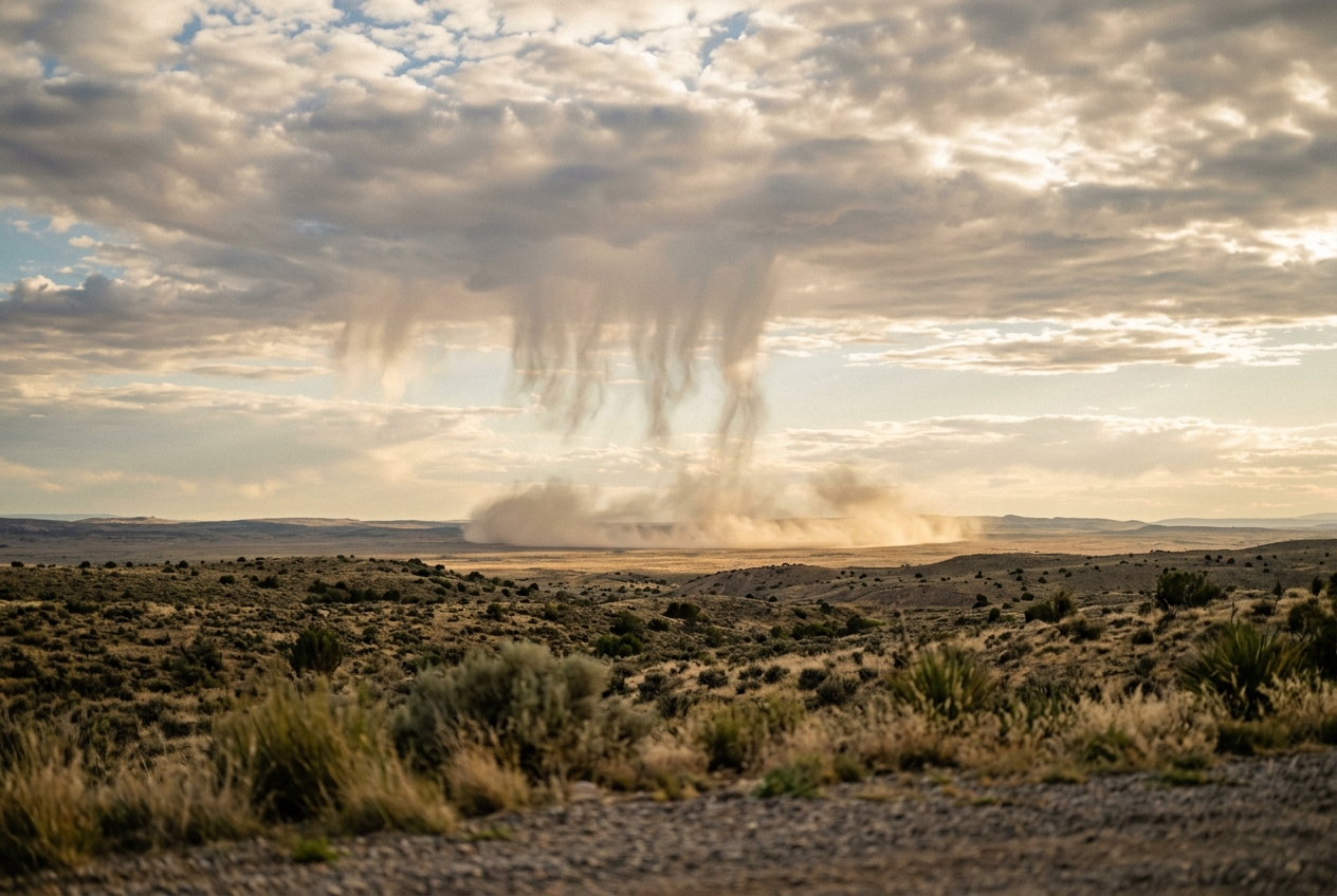
Stand on the high desert plateau of the American Great Basin or the arid expanse of the Australian Outback in late July, and the atmosphere presents a paradox of sublime beauty and unseen peril. The afternoon air is searing and baked to a brittle 38°C. Underfoot, the cracked clay radiates heat in shimmering mirages that distort the distant mountain ranges. Overhead, the sky is not clear; rather, it is punctuated by towering, flat-bottomed altocumulus castellanus and high-based cumulus congestus clouds, their dark bases suspended four thousand metres above the surface.
From the underbellies of these slate-grey cloud decks hang delicate, fibrous curtains. They drift downwards like the translucent tentacles of a giant celestial jellyfish, swaying gently in the mid-tropospheric steering winds. These are shafts of heavy precipitation—torrents of water droplets cascading from the cloud core. Yet, as you watch, something uncanny occurs: the dark shafts fray, taper into feathery brushstrokes, and dissolve into thin air two kilometres above the ground. Not a single drop strikes your skin.
       [ HIGH-BASED CLOUD: 4,000 m AGL ]
         ~~~~~~~~~~~~~~~~~~~~~~~~~~~~~
               \   \   \   \   \   <-- Heavy rain shaft exits cloud base
                \   \   \   \   \
                 \   \   \   \     <-- Intense Evaporative Cooling (dQ/dt < 0)
                  :   :   :   :    <-- Droplets shrink & vanish (Virga)
                   .   .   .   .   <-- Dense, chilled air parcel plunges (w_max)
                       |
                       v
=================== [ GROUND IMPACT ] ===================
 <--- Violent Radial Outflow (u_max) / Haboob Dust Wall --->
For a few moments, the silence of the desert remains unbroken. Then, you catch the sudden, metallic scent of petrichor—the smell of rain-kissed earth—drifting on a faint breeze, despite the bone-dry soil around you. The hairs on your arms stand up as the ambient temperature abruptly plunges by ten degrees Celsius in a matter of seconds. The stillness shatters with explosive violence. A deafening roar accompanies a wall of blinding dust, kicked up from the desert floor as a hurricane-force gust slams into your chest. There is still no rain, only a howling, desiccating wind that tears branches from scrub oaks and sends gravel rattling against rock faces. You have just witnessed the birth and touchdown of a dry microburst: an invisible atmospheric avalanche driven by the physics of virga.
2. What's Actually Happening: The Invisible Refrigeration Cycle
To understand how a phantom rain shower turns into a violent ground-level storm, one must look at the atmosphere not as an empty void, but as a colossal, layered thermodynamic engine.
Think of the lower atmosphere as a giant, thirsty sponge. On hot, arid afternoons, the air near the surface is exceptionally dry, while the air several kilometres aloft is cold and humid enough to condense water vapour into clouds. When these high clouds release their payload of liquid raindrops, those drops do not fall through saturated air; instead, they plummet into a vast desert of parched, unsaturated air beneath the cloud deck.
The moment liquid water enters dry air, nature attempts to restore equilibrium through evaporation. But evaporation is not a passive disappearance—it is an aggressive thermodynamic transaction. In everyday life, when you step out of a swimming pool on a breezy day, you immediately feel chilled. Even if the sun is blazing, your skin cools rapidly because the water evaporating from your body must absorb heat from its surroundings to transform from a liquid into a gas. This absorbed energy is known as latent heat.
The exact same refrigeration mechanism operates beneath a virga cloud, but on a gargantuan scale:
+-------------------------------------------------------------------------+
|                  THE SUB-CLOUD REFRIGERATION CASCADE                    |
+-------------------------------------------------------------------------+
|  1. Raindrops fall into dry, hot sub-cloud air layer.                  |
|  2. Droplets evaporate rapidly, robbing ambient air of thermal energy.  |
|  3. Air parcel chills towards its wet-bulb temperature (Tw << T).       |
|  4. Chilled air becomes drastically denser than surrounding warm air.   |
|  5. Negative buoyancy pulls the dense parcel earthward at high speed.   |
|  6. Downward shaft strikes ground and blasts outwards as a microburst.  |
+-------------------------------------------------------------------------+
As millions of tonnes of raindrops vaporise mid-fall, they rob the surrounding air of enormous quantities of thermal energy. The air within the falling shaft cools drastically relative to the baking environment around it. Because cold air is denser and heavier than warm air, this chilled parcel loses all its buoyancy. It transforms into an airborne lead weight. Pulled down by gravity and accelerated by the continuous cooling of evaporating water, the parcel cascades towards the earth like an invisible waterfall, smashing into the ground and blasting outwards in all directions as a destructive gale.
According to the official World Meteorological Organization (WMO) International Cloud Atlas, virga is defined formally as precipitation trails falling from a cloud that do not reach the Earth's surface. Yet, while the water never reaches the soil, the mechanical energy generated by its evaporation most certainly does.
3. The Science: Microphysics, Thermodynamics, and Momentum
To quantify the destructive power of virga, atmospheric scientists dissect the phenomenon into four interrelated physical regimes: droplet microphysics, thermodynamic soundings, negative buoyancy acceleration, and ground-impact fluid dynamics.
A. Droplet Evaporation Microphysics
The rate at which a falling spherical raindrop loses mass is governed by vapour diffusion away from the droplet surface into the unsaturated ambient air, enhanced by the turbulent airflow around the falling drop (ventilation).
In atmospheric physics, the mass loss rate of a single drop of radius $r$ is predicted by the classical Maxwellian diffusion relation modified by a ventilation coefficient:
$$\frac{dm}{dt} = 4\pi r \left( \frac{D_v M_w}{R^* T} \right) \left[ e - e_s(T_d) \right] f_v$$
-
Plain English Meaning: This equation predicts how quickly a single raindrop shrinks as it falls. It states that the rate of water lost per second ($\frac{dm}{dt}$) is directly proportional to the size of the raindrop ($r$), the dryness of the surrounding air (the vapour pressure deficit $[e - e_s(T_d)]$), and the speed at which the drop is falling through the air (the ventilation factor $f_v$).
-
Variable Breakdown:
- $r$: Droplet radius ($\text{m}$)
- $D_v$: Molecular diffusivity of water vapour in air ($\approx 2.5 \times 10^{-5} \text{ m}^2/\text{s}$)
- $M_w$: Molecular weight of water ($0.018015 \text{ kg/mol}$)
- $R^*$: Universal gas constant ($8.314 \text{ J}/(\text{mol}\cdot\text{K})$)
- $T$: Absolute ambient temperature ($\text{K}$)
- $e$: Ambient water vapour pressure ($\text{Pa}$)
- $e_s(T_d)$: Saturation vapour pressure at the droplet surface temperature $T_d$ ($\text{Pa}$)
- $f_v$: Empirical ventilation coefficient ($f_v \approx 1 + 0.23 \cdot \text{Re}^{1/2}$, where $\text{Re}$ is the Reynolds number of the falling drop)
Worked Example: Consider a raindrop of radius $r = 1.0 \times 10^{-3} \text{ m}$ ($1\text{ mm}$, mass $m \approx 4.19 \times 10^{-6}\text{ kg}$) falling through a dry sub-cloud layer at $T = 305\text{ K}$ ($32^\circ\text{C}$) where ambient vapour pressure is $e = 1,200\text{ Pa}$, while the saturation vapour pressure at the droplet surface is $e_s(T_d) = 3,500\text{ Pa}$. The vapour deficit is therefore $e - e_s(T_d) = -2,300\text{ Pa}$.
Assuming a ventilation factor $f_v \approx 2.2$ for a drop falling near terminal velocity: $$\frac{dm}{dt} = 4\pi (1.0 \times 10^{-3}) \left( \frac{2.5 \times 10^{-5} \times 0.018015}{8.314 \times 305} \right) (-2300) \times 2.2$$ $$\frac{dm}{dt} \approx (1.2566 \times 10^{-2}) \times (1.777 \times 10^{-7}) \times (-5060) \approx -1.13 \times 10^{-8} \text{ kg/s}$$
At this rate of mass loss, a $1\text{ mm}$ raindrop loses roughly $1\%$ of its total mass every three to four seconds. As the radius shrinks, the ratio of surface area to volume increases ($A/V \propto 1/r$), causing the evaporation rate per unit mass to accelerate exponentially until the drop completely vanishes mid-air.
B. The Thermodynamic 'Inverted-V' Sounding
When meteorologists evaluate atmospheric soundings via Skew-T log-P diagrams from weather balloons, environments primed for severe virga downdrafts exhibit an unmistakable signature known as the "Inverted-V" profile.
                   SKEW-T: THE 'INVERTED-V' PROFILE
  Pressure (hPa)
    500 |                  / Cloud Base (LCL) ~ 600 hPa
        |                 /\
    600 |                /  \
        |               /    \  <-- Dewpoint depression widens
    700 |              /      \
        |    Dewpoint /        \ Temperature
    800 |     Trace  /          \  Trace
        |           /            \
    900 |          /              \  <-- Deep, Dry-Adiabatic Boundary Layer
        |         /                \     (Lapse rate ~ 9.8 K/km)
   1000 +--------/------------------\----> Temperature (°C)
               -10°C   10°C   30°C
In this sounding: 1. High Cloud Base: The Lifted Condensation Level (LCL) resides high above the ground, typically between $600\text{ hPa}$ and $500\text{ hPa}$ ($3,500\text{ m}$ to $5,500\text{ m}$ above ground level). 2. Deep, Dry Sub-Cloud Layer: Below the cloud base, the temperature profile traces the dry adiabatic lapse rate ($\Gamma_d \approx 9.8\text{ K/km}$) all the way to the surface. 3. Massive Dewpoint Depression: Near the ground, the environmental temperature $T$ and dewpoint $T_d$ diverge dramatically, creating a dewpoint depression ($T - T_d$) often exceeding $25^\circ\text{C}$ to $35^\circ\text{C}$, yielding relative humidities below $15\%$.
As rain falls into this deep Inverted-V layer, the latent heat absorbed per unit time is dictated by the latent heat of vaporisation ($L_v \approx 2.50 \times 10^6 \text{ J/kg}$):
$$\frac{dQ}{dt} = -L_v \frac{dm}{dt}$$
This immense heat extraction forces the air parcel's temperature down toward its wet-bulb temperature ($T_w$). In a sounding with a $30^\circ\text{C}$ dewpoint depression, the wet-bulb temperature can easily be $10^\circ\text{C}$ to $15^\circ\text{C}$ colder than the ambient environmental temperature ($T_w \ll T$). This creates an extreme negative virtual potential temperature perturbation ($\Delta \theta_v < 0$), rendering the parcel immensely denser than the surrounding ambient air.
C. Vertical Momentum Equation and Downdraft Velocity
The downward acceleration ($a_z = \frac{dw}{dt}$) of the chilled parcel is governed by the vertical momentum equation, incorporating thermal buoyancy deficits and hydrometeor mass loading:
$$a_z = \frac{dw}{dt} = g \left( \frac{\theta_v - \bar{\theta}_v}{\bar{\theta}_v} \right) - g q_l \approx g \left( \frac{\Delta T_v}{\bar{T}_v} \right) - g q_l$$
-
Plain English Meaning: This equation calculates how fast a pocket of air accelerates towards the earth. It proves that the downward acceleration ($a_z$) is driven by two factors: how much colder and denser the parcel is compared to the surrounding air ($\frac{\Delta T_v}{\bar{T}_v}$, which is negative), minus the physical drag weight of the liquid water drops suspended within it ($-g q_l$).
-
Variable Breakdown:
- $g$: Acceleration due to gravity ($9.81 \text{ m/s}^2$)
- $\Delta T_v = T_{v,\text{parcel}} - \bar{T}_{v,\text{env}}$: Virtual temperature perturbation ($\text{K}$)
- $\bar{T}_v$: Mean ambient virtual temperature ($\text{K}$)
- $q_l$: Liquid water mixing ratio ($\text{kg of liquid water / kg of dry air}$)
Integrating this negative buoyancy acceleration over the vertical depth of the sub-cloud evaporative layer ($H = z_{\text{base}} - z_{\text{surface}}$) gives the theoretical maximum downward impact velocity ($w_{\max}$):
$$w_{\max} \approx \sqrt{2 \int_{0}^{H} |B(z)| \, dz}$$
where $B(z) = g \left( \frac{\Delta T_v(z)}{\bar{T}_v(z)} - q_l(z) \right)$ represents the net negative buoyancy.
Worked Example: Suppose a rain shaft evaporates beneath a cloud base located $H = 3,000\text{ m}$ above the surface. Due to evaporative cooling, the descending parcel maintains an average virtual temperature deficit $\Delta T_v = -6.0\text{ K}$ relative to a mean ambient temperature $\bar{T}_v = 300\text{ K}$. For simplicity, assume hydrometeor loading is negligible near the end of evaporation ($q_l \approx 0$).
Calculate the magnitude of the negative buoyancy acceleration $|B|$: $$|B| = g \left| \frac{\Delta T_v}{\bar{T}_v} \right| = 9.81 \times \left( \frac{6.0}{300} \right) = 9.81 \times 0.020 = 0.1962 \text{ m/s}^2$$
Calculate the peak downdraft velocity $w_{\max}$ upon reaching the ground: $$w_{\max} = \sqrt{2 \times |B| \times H} = \sqrt{2 \times 0.1962 \text{ m/s}^2 \times 3,000 \text{ m}}$$ $$w_{\max} = \sqrt{1,177.2} \approx 34.31 \text{ m/s} \quad (\approx 123.5 \text{ km/h} \text{ or } 66.7 \text{ knots})$$
This demonstrates that a mere $6\text{ K}$ temperature deficit maintained over three kilometres produces a catastrophic vertical plunge exceeding hurricane velocity.
D. Ground Impact and Radial Outflow Dynamics
When this high-velocity vertical jet strikes the unyielding boundary of the Earth's surface, fluid mechanics dictates that the vertical momentum must be converted into horizontal momentum.
                    STRUCTURE OF A DRY MICROBURST

                           |  |  |  |  |
                           |  Downdraft|
                           |  (w_max)  |
                           v  v  v  v  v

                          [Stagnation Zone]  --> High Pressure Core (+ΔP)
       Vortex Ring       /                 \       Vortex Ring
         @@@@@          /                   \        @@@@@
       @       @ <=====                       =====> @       @
      @  <---   @     Horizontal Outflow (u_max)    @   --->  @
=================================================================== Ground
As the downburst impinges on the flat terrain, it creates a stagnation point directly under the centre of the column. By Bernoulli's principle for streamline flow, the kinetic energy of the vertical downdraft transforms into a localised dynamic pressure spike known as stagnation pressure ($\Delta P$):
$$\Delta P = \frac{1}{2} \rho w_{\text{impact}}^2$$
where $\rho$ is the density of the chilled air parcel ($\approx 1.15 \text{ to } 1.25 \text{ kg/m}^3$).
This elevated pressure core drives an intense horizontal pressure gradient, forcing the dense air to accelerate radially outward in a burst of destructive surface winds ($u_{\max}$). As the spreading air encounters ambient air, it curls back on itself due to shear vorticity, forming an expanding, turbulent vortex ring (a horizontal rotor).
Over arid soil, this outward density current scours loose silt and sand into an opaque, advancing dust wall known meteorologically as a haboob (from the Arabic habūb, meaning blasting wind), as documented by the NOAA National Severe Storms Laboratory.
+-------------------------------------------------------------------------+
|                  MICROBURST CLASSIFICATION BENCHMARKS                   |
+-------------------------------------------------------------------------+
|  Metric                   | Dry Microburst      | Wet Microburst        |
+---------------------------+---------------------+-----------------------+
|  Surface Precipitation    | None to < 0.25 mm   | Heavy (> 25 mm/hr)    |
|  Horizontal Extent        | < 4 km diameter     | < 4 km diameter       |
|  Outflow Wind Speeds      | 15 to > 45 m/s      | 15 to > 50 m/s        |
|  Primary Forcing          | Evaporative cooling | Precipitation loading |
|  Precipitation Profile    | Virga / Inverted-V  | Deep, moist troposphere|
|  Stagnation Pressure ΔP   | +2.0 to +8.0 hPa    | +3.0 to +12.0 hPa     |
+-------------------------------------------------------------------------+
4. Practical Outdoor Guidance: Identifying High-Risk Virga Columns
For hikers, wilderness explorers, aviators, and mariners, virga must never be dismissed as a benign optical curiosity. It is the visible exhaust of a potentially lethal vertical wind system. To evaluate the threat of an impending dry microburst, observe the following visual, barometric, and thermal indicators.
A. Sky and Cloud Formations to Watch
- The "Curled Foot" or Frayed Base: When looking at virga curtains, look at the bottommost edge of the evaporating streak. If the shaft hangs vertically and fades smoothly, the downdraft velocity is moderate. If the base of the virga shaft curls horizontally, curves into a sickle shape, or exhibits rapid horizontal spreading thousands of feet in the air, the cold air is already descending rapidly and deflecting outward.
- High Cloud Bases with Dark Knots: Watch for high-based clouds (altocumulus castellanus or high-based cumulus congestus) where the cloud base is higher than $3,000\text{ m}$ ($10,000\text{ ft}$) above ground level on a hot afternoon ($> 30^\circ\text{C}$). Dark, dense "knots" or mammatus formations on the underside of these clouds indicate severe turbulent mixing and precipitation cores.
- The Distant "Dust Skirt": In arid regions, scan the horizon beneath virga curtains. If you see a sudden, expanding ring or mushroom-shaped plume of dust billowing outward along the ground with no visible rain reaching the surface, a dry microburst has just struck ground level. The blast wave typically travels outward at $50\text{ to }100\text{ km/h}$, reaching observers several kilometres away within two to five minutes.
       VISUAL CUES: BENIGN VIRGA VS. SEVERE DOWNDRAFT VIRGA

[ BENIGN VIRGA ]                  [ DANGEROUS VIRGA CORE ]
          ~~~~~~~~~~~~~~                        ~~~~~~~~~~~~~~
             |  |  |  |                            |  |||||  |
             |  |  |  |                            |  |||||  |
             :  :  :  :                            \  |||||  /
              .  .  .                               \ ||||| /  <-- Funneling
                                                     \ --- /   <-- Sickle Curl
      (Smooth, slow fade;
       no surface disruption)                         |   |
                                                      v   v
                                                 @@@@@@@@@@@@@ <-- Dust Skirt
B. Instrument Readings to Monitor
- The Barometer: Watch for a sudden, sharp pressure jump of $+1.5\text{ to }+6.0\text{ hPa}$ on your digital altimeter or barometer over a 60-second window. This pressure surge marks the arrival of the stagnation high-pressure bubble beneath the downburst.
- The Thermometer: A sudden, steep temperature drop of $5^\circ\text{C}\text{ to }12^\circ\text{C}$ on an otherwise scorching afternoon indicates that the cold, evaporatively chilled air parcel has arrived at surface level.
- Wind Direction & Velocity: A dead calm that abruptly shifts by $90^\circ\text{ to }180^\circ$ and accelerates into gusting gale-force winds within ten seconds is the classic signature of the outflow boundary.
C. Aviation and Wilderness Protocols
- For Aviators: As pioneered in microburst research by Dr. Ted Fujita and taught across UCAR MetEd Training Modules, flying into a dry microburst presents extreme Low-Level Wind Shear (LLWS). An aircraft on approach first encounters a strong headwind (increasing lift and causing the pilot to reduce throttle), followed immediately by a fierce downdraft, and then an abrupt, catastrophic tailwind (causing instantaneous loss of airspeed, wing stall, and ground impact). Modern airports employ Terminal Doppler Weather Radar (TDWR) and Low-Level Wind Shear Alert Systems (LLWAS) specifically to detect these invisible virga outflows.
- For Hikers and Campers: If you observe virga developing overhead on a hot, dry afternoon, immediately secure loose gear, move away from dead trees or canyon rims susceptible to wind-throw and rockfalls, and prepare for immediate drops in visibility due to blowing sand. If navigating open water, drop sails and head into the wind before the gust front arrives.
5. Today's Meteorological Rule of Thumb
The Virga Vigilance Axiom:
When rain falls from high clouds into hot, bone-dry air, the water you see vanishing above is mechanical energy falling toward your feet. If the sky is raining ghosts on a scorching afternoon, expect the wind of a tempest.
Authoritative Meteorological References
- WMO International Cloud Atlas — Definition and Characteristics of Virga
- Met Office UK — Cloud Features and Precipitation Shafts
- NOAA National Severe Storms Laboratory — Severe Weather: Microbursts and Downbursts
- American Meteorological Society — Glossary of Meteorology: Dry Microburst Dynamics
- Wikipedia — Microburst Mechanics and Atmospheric Hazard Profiles