Trade Wind Inversion & Marine Stratocumulus Dynamics: How Subtropical Subsidence and Cloud-Top Radiative Cooling Sustain Vast Oceanic Cloud Decks
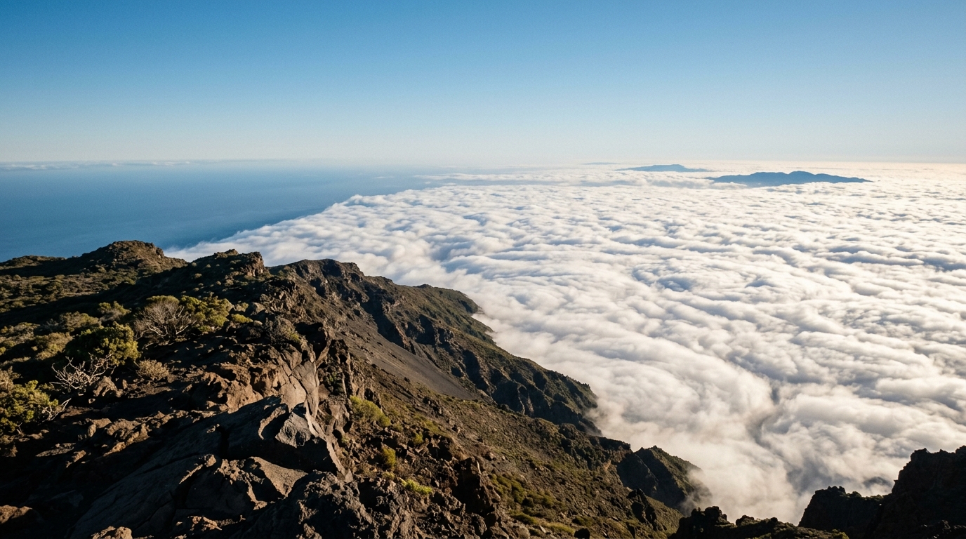
1. Opening Scene: Above the Sun-Bleached Sea of Clouds
If you hike up the coastal spine of Mount Tamalpais north of San Francisco or ascend the volcanic caldera rim of La Palma in the Canary Islands on a midsummer morning, you will experience one of the most abrupt sensory bifurcations found anywhere on Earth.
At the trailhead along the shore, the air is cold, heavy, and saturated. A salt-tinged, 12°C fog clings to your jacket in microscopic beads; your lungs fill with a damp, mineral chill, and the visibility barely extends fifty paces into the grey murk. The ambient light is flat and diffuse, casting neither shadow nor warmth.
Yet, as you climb past 700 metres, the fog thins to a translucent veil. Within twenty vertical strides, you breach the top of the cloud deck and emerge into blinding Mediterranean sunlight. The physical transformation is instantaneous and disorienting. The temperature leaps from a shiver-inducing 12°C to a bone-dry 26°C. The relative humidity plummets from near 100% to less than 15%, crisping the scent of dry coastal sage and pine needles beneath your boots.
Looking back westward, the Pacific Ocean has vanished entirely. In its place lies an immaculate, blindingly white expanse of marine stratocumulus stretching to the curvature of the horizon. It looks solid enough to walk upon—a vast, corrugated pavement of alabaster cloud tops capped by an invisible, mathematically precise glass ceiling. Above you, the sky is a deep, pristine cobalt, stripped of haze and cloud. Below you, half a million square kilometres of ocean breathe silently beneath a thermal trapdoor.
2. What’s Actually Happening — Plain English First
To understand why this cloud deck exists—and why it refuses to rise even ten metres higher into the blue—we must examine how the atmosphere organizes itself across entire ocean basins.
The Atmosphere as a Layered Cake
Under normal atmospheric conditions, the air gets colder the higher you climb. This is why high alpine peaks remain snow-capped in summer: air expands and cools as it rises into regions of lower pressure. However, over the eastern margins of the world’s subtropical oceans (off the coasts of California, Peru, Namibia, the Canary Islands, and Western Australia), the atmosphere flips upside down. A layer of hot, dry air sits directly atop a layer of cold, damp marine air. Meteorologists call this an atmospheric inversion.
Think of this subtropical system as a four-tier cake:
- The Sub-Cloud Mixed Layer (Sea surface to ~500 m): Cold ocean currents—fed by polar melt and coastal upwelling—chill the air directly above the water. Ocean waves generate friction and moisture, evaporating seawater into the chilled air. Convective turbulence constantly stirs this bottom layer like a well-whipped batter, distributing moisture evenly.
- The Marine Stratocumulus Cloud Layer (~500 m to ~900 m): As the moist surface air is stirred upward, it reaches its lifting condensation level. The water vapour condenses into a uniform, low-lying sheet of cloud. This layer acts as a colossal planetary sunshade, bouncing between 40% and 70% of incoming solar radiation back into space.
- The Trade Wind Inversion Capping Lid (~900 m to ~1,100 m): Directly above the cloud lies a razor-thin transition zone, often less than 100 metres thick. Here, the temperature abruptly spikes by 5°C to 15°C while moisture levels plummet. This warm, light air acts as a rigid lid. Because warm air is less dense than cold air, the cold, heavy cloud below cannot push upward through it. Buoyancy firmly denies the cloud entry.
- The Free Troposphere (Above ~1,100 m): Above the inversion sits the vast, unmixed upper atmosphere. This air is pristine, hyper-dry, and descending constantly from the upper reaches of the tropical atmosphere.
The Great Planetary Heat Pump
Why is the upper air so warm and dry? The answer lies in the Hadley Circulation, the giant thermodynamic engine of the tropics documented extensively by the World Meteorological Organization.
Near the equator, intense solar heating drives moist air thousands of metres into the upper troposphere. Having dumped its moisture as torrential equatorial rain, this high-altitude air travels poleward toward 30° North and South latitude. There, it cools radiatively and sinks back toward the sea surface in a process known as large-scale subsidence.
As this bone-dry air descends, it is squashed by the increasing weight of the atmosphere above it. This compression heats the air dry-adiabatically at roughly 9.8°C per kilometre of descent. By the time it arrives over the subtropical oceans, it is exceptionally warm and thirsty. When this descending, compressing air collides with the cold marine layer crawling off the upwelling ocean currents, they do not mix smoothly. Instead, the warm air pancaking downward traps the cold marine layer beneath a permanent lid: the Trade Wind Inversion.
The Upside-Down Thunderstorm
The most counter-intuitive feature of a marine stratocumulus cloud deck is how it sustains its internal turbulence.
Standard overland clouds (like towering cumulus or afternoon thunderstorms) are driven from the bottom up. The sun heats the dark ground, creating warm, buoyant parcels of air that rise like hot-air balloons. But over the subtropical ocean, the sea surface is cold, often colder than the air blowing across it.
Instead, marine stratocumulus is driven from the top down. The top of the cloud deck emits infrared (longwave) radiation directly out to space through the dry, transparent free troposphere above it. This radiative heat loss chills the droplets at the very top skin of the cloud. This newly chilled, ultra-dense water-air mixture sinks rapidly in narrow, turbulent downdrafts, plunging toward the ocean surface and forcing warmer, moist air from below to rise into the gaps. The cloud deck literally powers its own turbulent circulation by refrigerating its roof against the cold void of space.
3. The Science (for those who want to go deeper)
To formalize the physics governing this delicate equilibrium, atmospheric dynamicists model the marine boundary layer as a well-mixed slab governed by thermodynamic budgets and turbulent fluxes.
Equation 1: The Mixed-Layer Height Budget
What determines the exact altitude of that sharp cloud ceiling?
In plain English: The height of the cloud top is a continuous tug-of-war between two competing velocities. On one side, large-scale subsidence ($w_s$) pushes the inversion downward like a heavy hand pressing on a piston. On the other side, turbulent vortices within the cloud churn upward, chewing into the warm air above and entraining it into the marine layer at an entrainment velocity ($w_e$).
When these two rates balance, the inversion height ($z_i$) remains stationary:
$$\frac{d z_i}{dt} = w_e + w_s = w_e - D z_i$$
Where: * $z_i$ is the height of the trade wind inversion base (the cloud top, in metres). * $w_e$ is the turbulent entrainment velocity ($\text{m s}^{-1}$), representing how fast the cloud deck erodes into the free troposphere. * $w_s = -D z_i$ is the large-scale subsidence velocity ($\text{m s}^{-1}$). * $D = -\left(\frac{\partial u}{\partial x} + \frac{\partial v}{\partial y}\right) = \frac{\partial w}{\partial z}$ is the large-scale horizontal wind divergence ($\text{s}^{-1}$).
At steady state ($\frac{d z_i}{dt} = 0$), the equilibrium inversion height simplifies directly to:
$$z_{i,\text{eq}} = \frac{w_e}{D}$$
Worked Numerical Example:
Consider a typical summer regime off the California coast monitored by the National Oceanic and Atmospheric Administration (NOAA): * Measured large-scale divergence: $D = 5.0 \times 10^{-6} \text{ s}^{-1}$ (a gentle horizontal spreading of the subtropical anticyclone). * Cloud-top entrainment velocity driven by radiative cooling: $w_e = 0.45 \text{ cm s}^{-1} = 0.0045 \text{ m s}^{-1}$.
Calculating the equilibrium cloud top height:
$$z_{i,\text{eq}} = \frac{0.0045 \text{ m s}^{-1}}{5.0 \times 10^{-6} \text{ s}^{-1}} = 900 \text{ metres}$$
At this altitude, the downward push of the descending Hadley cell precisely matches the upward turbulent churn of the cloud deck. If divergence weakens to $D = 3.0 \times 10^{-6} \text{ s}^{-1}$, the cloud ceiling lifts to $1,500\text{ m}$. If subsidence intensifies to $D = 8.0 \times 10^{-6} \text{ s}^{-1}$, the deck is crushed downward to a shallow fog layer at $560\text{ m}$.
The Energetics of Top-Down Overturning
The entrainment velocity $w_e$ is not an arbitrary constant; it is fundamentally powered by the net longwave radiative cooling divergence across the cloud top ($\Delta F_{\text{rad}}$).
As research from the European Centre for Medium-Range Weather Forecasts (ECMWF) demonstrates, the cloud top emits approximately $60 \text{ to } 90 \text{ W m}^{-2}$ of net infrared flux into space. This cooling produces a negative buoyancy flux at the cloud top:
$$B_{\text{top}} = -\frac{g}{\theta_{v0}} \frac{\Delta F_{\text{rad}}}{\rho c_p}$$
This negative buoyancy creates sinking convective plumes that stir the entire marine boundary layer from the top down, keeping the sub-cloud and cloud layers coupled as a single well-mixed thermodynamic engine.
Equation 2: Cloud-Top Entrainment Instability (CTEI)
What happens when dry, warm inversion air is pulled downward into the moist cloud deck?
In plain English: When warm, dry air mixes with cloudy air, two opposing forces compete. The warmth of the entrained air tends to make the mixture lighter (positive thermal buoyancy). However, the extreme dryness of the entrained air forces cloud droplets to evaporate instantly. Evaporation absorbs latent heat, chilling the mixture. If the evaporative cooling outweighs the thermal warming, the mixed parcel becomes colder and denser than the surrounding cloud, causing it to sink violently. This runaway feedback is called Cloud-Top Entrainment Instability (CTEI), first formulated by Randall (1980) and Deardorff (1980).
The stability of the cloud deck against catastrophic evaporative breakup is governed by the Randall-Deardorff buoyancy jump parameter $\kappa$:
$$\kappa = 1 + \frac{c_p \Delta \theta_v}{L \Delta q_t} = 1 - \frac{c_p |\Delta \theta_v|}{L |\Delta q_t|}$$
Where the critical threshold for instability is:
$$\kappa > \kappa_{\text{crit}} \approx 0.23 \quad \Longleftrightarrow \quad \Delta \theta_e < 0$$
Where: * $\Delta \theta_v = \theta_{v,\text{free}} - \theta_{v,\text{cloud}}$ is the jump in virtual potential temperature across the inversion ($\text{K}$). * $\Delta q_t = q_{t,\text{free}} - q_{t,\text{cloud}}$ is the jump in total water mixing ratio across the inversion ($\text{kg kg}^{-1}$ or $\text{g kg}^{-1}$, which is negative because the free troposphere is dry). * $c_p = 1005 \text{ J kg}^{-1} \text{K}^{-1}$ is the isobaric specific heat capacity of dry air. * $L = 2.501 \times 10^6 \text{ J kg}^{-1}$ is the latent heat of vaporization of water. * $\theta_e$ is the equivalent potential temperature.
Worked Numerical Example:
Let us evaluate two different maritime sectors using operational sounding profiles from the Met Office:
Case A: A Stable Closed-Cell Stratocumulus Deck (Coastal California) * Virtual potential temperature jump: $\Delta \theta_v = +10.0 \text{ K}$ (strong thermal capping). * Total water jump: $\Delta q_t = -5.0 \text{ g kg}^{-1} = -0.0050 \text{ kg kg}^{-1}$.
We calculate $\kappa$:
$$\kappa = 1 - \frac{(1005 \text{ J kg}^{-1}\text{K}^{-1})(10.0 \text{ K})}{(2.501 \times 10^6 \text{ J kg}^{-1})(0.0050 \text{ kg kg}^{-1})} = 1 - \frac{10050}{12505} = 1 - 0.804 = 0.196$$
Because $\kappa = 0.196 < 0.23$, the thermal buoyancy jump easily resists evaporative cooling. The cloud deck is statically stable and remains a continuous, unbroken, reflective sheet.
Case B: An Unstable, Breaking Cloud Deck (Downstream Transition Zone) * Virtual potential temperature jump: $\Delta \theta_v = +3.0 \text{ K}$ (weakened inversion). * Total water jump: $\Delta q_t = -8.0 \text{ g kg}^{-1} = -0.0080 \text{ kg kg}^{-1}$ (extremely dry air aloft).
We calculate $\kappa$:
$$\kappa = 1 - \frac{(1005 \text{ J kg}^{-1}\text{K}^{-1})(3.0 \text{ K})}{(2.501 \times 10^6 \text{ J kg}^{-1})(0.0080 \text{ kg kg}^{-1})} = 1 - \frac{3015}{20008} = 1 - 0.151 = 0.849$$
Here, $\kappa = 0.849 \gg 0.23$. Any parcel of dry inversion air dragged into the cloud evaporates so much liquid water that it becomes dramatically heavier than the surrounding cloud. It accelerates downward in an evaporatively driven downdraft, ripping holes in the stratocumulus sheet and shattering the continuous overcast into broken cumulus clouds.
The Downstream Lagrangian Odyssey: From Sheet to Shards
As the low-level trade winds blow equatorward and westward away from the cold upwelling coasts, the marine boundary layer undergoes a profound structural metamorphosis.
Over the course of a three-to-five day journey (for example, along the 3,500-kilometre path from San Francisco to Honolulu): 1. Rising Sea Surface Temperatures (SSTs): The ocean beneath the clouds warms from 14°C to 25°C. This injects strong surface sensible and latent heat fluxes into the bottom of the boundary layer. 2. Boundary Layer Deepening and Decoupling: The boundary layer deepens from $800\text{ m}$ to over $2,000\text{ m}$. As it deepens, the top-down radiative cooling can no longer stir the full depth of the column down to the sea surface. The boundary layer decouples into two distinct sub-layers: a surface mixed layer and an elevated cloud layer. 3. Cumulus Under Stratocumulus: Mini-cumulus towers begin to sprout from the surface layer, punching into the base of the thinned stratocumulus deck from below. 4. Drizzle-Driven Depletion: As cloud droplets collide and grow, the deck begins to precipitate. This drizzle evaporates below cloud base, cooling the sub-cloud layer and stabilizing it further, cutting off the moisture supply from the sea. 5. The Trade Wind Cumulus Regime: The solid, planetary mirror of stratocumulus dissolves completely, leaving behind the classic scattered, puffy trade wind cumulus clouds documented in the Glossary of Meteorology.
This transition fundamentally alters the Earth's radiative balance, decreasing the local cloud albedo from 0.60 to less than 0.20 and allowing the tropical ocean to absorb vast amounts of solar energy.
4. Practical Outdoor Guidance
Whether you are navigating a sailboat through coastal waters, hiking mountain headlands, or monitoring microclimates, the trade wind inversion offers distinct, readable signatures in the field.
What to Look for in the Sky
- The Razor-Edge Cloud Horizon: When looking toward the coast from an elevation above 800 metres, observe the cloud top. If it appears dead flat, polished, and free of vertical mounds or towers, the trade wind inversion is exceptionally strong ($\Delta \theta_v > 8\text{ K}$). If ragged plumes or boiling domes punch through the top, the inversion is eroding, signaling an imminent change in coastal weather.
- The "Dirty Inversion" Band: Look just above the white cloud deck into the blue sky. You will frequently see a faint, brownish-grey horizontal band. This is urban smog, dust, and marine aerosols trapped precisely at the inversion base. The air above this line has descended from the upper troposphere and is among the cleanest, lowest-turbidity air on the planet.
Instrument Readings to Watch
- The Barometer: A high and steady barometric reading (typically $1018 \text{ to } 1024\text{ hPa}$) indicates strong subtropical high-pressure subsidence. The stronger the anticyclone, the lower and more intense the inversion ceiling.
- The Altimeter/Thermometer Profile: If you drive or hike up a coastal road with a vehicle thermometer or weather watch, track the lapse rate. Under standard conditions, temperature drops by $\approx 6.5^\circ\text{C}$ per $1,000\text{ m}$ ($0.65^\circ\text{C}$ per $100\text{ m}$). If you observe the temperature steadying and then abruptly climbing by $5^\circ\text{C} \text{ to } 12^\circ\text{C}$ across a vertical climb of just 50 to 100 metres, you have crossed the inversion base.
- Relative Humidity: A digital hygrometer will read $90\%\text{--}100\%$ within the coastal fog, dropping precipitously to $10\%\text{--}20\%$ the moment you crest the inversion height.
Outdoor Rules of Thumb
- For Hikers & Trail Runners: When the marine layer is forecasted below 600 metres, coastal summits are guaranteed to be sunny, hot, and dry. Pack sun protection, extra water, and light clothing even if the trailhead is freezing and fog-bound. Prepare for intense solar radiation above the cloud deck due to the combined direct sunlight and upward reflection from the cloud pavement below.
- For Coastal Mariners & Sailors: The trade wind inversion acts as an atmospheric duct for VHF radio transmissions and marine radar, bending electromagnetic signals along the curvature of the sea surface beneath the inversion lid. Expect radar ranges to extend unusually far within the marine layer, while visual fog remains impenetrable. Furthermore, expect wind speeds to accelerate sharply where coastal headlands squeeze this shallow marine layer through narrow geographic gaps (gap winds and coastal jets).
5. Today's Meteorological Rule of Thumb
The Subtropical Inversion Law: When warm, dry air sinks from the heavens, it builds an unyielding ceiling over the sea—and the clouds beneath survive not by heat from the water, but by refrigerating their own roofs against the cold void of space.
The next time you gaze across a flat, unbroken sea of coastal fog from a sunlit mountain peak, remember that you are not just looking at weather; you are standing on the structural boundary of the planetary heat engine, gazing down upon the cold mirror that keeps our world cool.