Seeder-Feeder Mechanism & Orographic Precipitation Enhancement: How Upper-Level Ice Crystals Scavenge Low-Level Cap Clouds to Multiply Mountain Rainfall
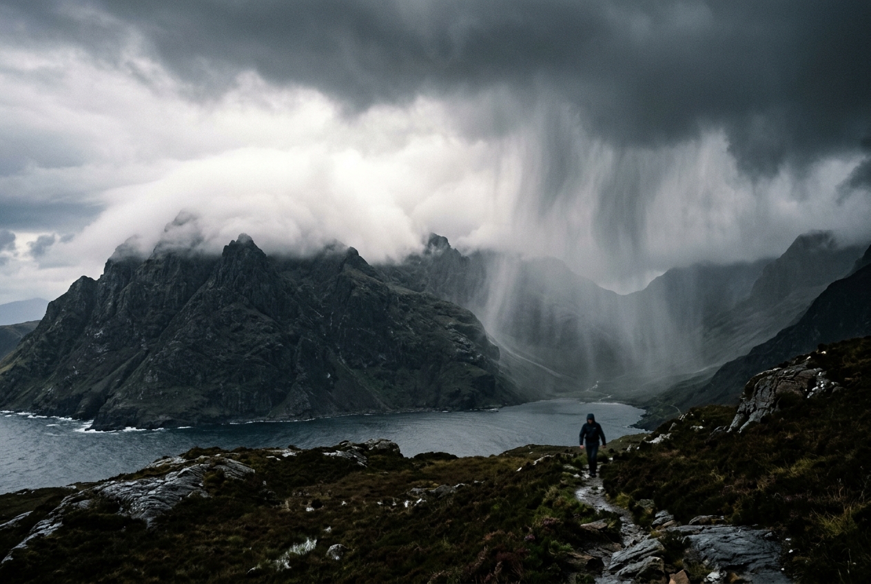
Ascending the windward flank of the Glen Shiel massif in the western Scottish Highlands, the atmosphere begins to telegraph a subtle, ominous shift long before the first heavy drops strike your jacket. At sea level, beside the slate-grey waters of Loch Duich, the morning air was mild, heavy with moisture, and cloaked in a monotonous, high-altitude overcast. The drizzle there was barely enough to warrant pulling a hood tight—a gentle, drifting Atlantic scotch mist that dampened the bracken without soaking the soil.
Yet, as you gain elevation, climbing through five hundred metres of heather and sodden peat, the physical environment transforms. The barometric pressure on your wrist altimeter drops steadily, but more noticeable is the air itself: cool, dense, and smelling sharply of ozone, moss, and wet granite. The wind, funnelled up the glaciated valley, stiffens into a relentless buffet. Looking upward, you notice that the high, pale ceiling of grey cloud has not changed its character, but an entirely separate, ragged cap of low cloud has formed across the jagged mountain crest. It clings to the ridges like wet wool, churning continuously as maritime air is rammed against the stone slopes.
       HIGH SEEDER CLOUD (Altostratus / Nimbostratus: Ice Crystals)
~~~~~~~~~~~~~~~~~~~~~~~~~~~~~~~~~~~~~~~~~~~~~~~~~~~~~~~~~~~~~~~~~~~~~~~~
    *   *   *   *   *   *   *   *   *   *   *   *   *   (Falling Ice/Snow)
      \   \   \   \   \   \   \   \   \   \   \   \
       v   v   v   v   v   v   v   v   v   v   v   v
                             _________________________
                            (  LOW FEEDER CAP CLOUD   )
                            ( Dense liquid droplets   )
   Moist Atlantic Wind      (=========================)
   ======================>  /  /  /  /  /  /  /  /  /   <-- HEAVY WASHOUT
                           /  /  /  /  /  /  /  /  /        TORRENTIAL RAIN
                          /  /  /  /  /  /  /  /  /
                         /_________________________\
                        /                           \
                       /       MOUNTAIN RIDGE        \
                      /                               \
Then, within a span of fifty paces across the exposed saddle, the character of the weather alters completely. The lazy, ambient mist suddenly converts into a blinding, torrential downpour. Heavy, swollen raindrops pelt against your hood with drumfire intensity, instantly overwhelming the water-repellent membrane of your gear. Streams materialize across the track where dry gravel lay ten minutes earlier. Looking up into the grey gloom, you realize you have stepped directly beneath nature’s most efficient atmospheric pump: the seeder-feeder mechanism.
What’s Actually Happening: The Two-Storey Cloud Factory
To understand why a modest ridge can turn a benign drizzle into a deluge, we must abandon the notion that rain clouds are single, uniform masses of vapour. The atmosphere across coastal and mountainous regions is rarely a single monolithic block; rather, think of it as a layered architectural structure—a two-storey house where each floor performs a completely distinct microphysical role in manufacturing precipitation.
The upper floor—the seeder cloud—resides high in the troposphere, typically between three and six kilometres aloft. This layer consists of widespread, synoptically driven cloud decks such as altostratus or nimbostratus, associated with approaching warm fronts or occlusions. Up here, ambient temperatures are well below freezing, often between $-10^\circ\text{C}$ and $-25^\circ\text{C}$. In this sub-zero realm, water vapour does not merely condense into droplets; it deposits onto microscopic freezing nuclei to create billions of pristine, geometric ice crystals.
The ground floor of our atmospheric house—the feeder cloud—is entirely local, pinned directly to the geography below. When a swift, moisture-laden maritime wind strikes a mountain range, the air has nowhere to go but up. As this air is forced to rise, it expands under lower atmospheric pressure and cools. Because maritime air is already near its saturation point, even a modest lift of a few hundred metres forces rapid condensation, spawning a low-altitude cap cloud or stratus layer crammed with millions of microscopic liquid water droplets.
Crucially, on its own, this lower feeder cloud is largely sterile. The droplets inside it are microscopic—typically between 5 and 15 micrometres in diameter—and they are so buoyant that they float effortlessly within the air currents. Furthermore, the time it takes for an air parcel to blow up the windward slope, condense its water, and crest the ridge is extremely short—often just five to fifteen minutes. In the world of cloud microphysics, fifteen minutes is far too brief for tiny water droplets to collide, merge, and grow into raindrops heavy enough to overcome the updraft and fall to earth. Left to itself, the feeder cloud would merely sweep across the ridge and evaporate harmlessly down the leeward slope.
This is where the upper floor intervenes. The high seeder cloud continuously drops a steady curtain of ice crystals and snow aggregates into the feeder cloud below. As these frozen hydrometeors fall through the zero-degree isotherm, they melt into raindrops. As these raindrops plunge through the dense, water-rich feeder cloud, they act like high-speed sweeping brooms. They collide with and absorb the millions of suspended micro-droplets in their path—a process known as accretional washout.
By the time each raindrop emerges from the base of the feeder cloud, its mass has increased three- to tenfold. The mountain does not create the storm; rather, it sets a microphysical trap that washes out the moisture stored in low-level maritime winds with ruthless efficiency.
The Microphysics and Mathematics of Washout Kinetics
The fundamental physics governing this enhancement relies on the coupling of two distinct classical processes: the Bergeron-Findeisen process aloft, and kinematic collision-coalescence kinetics within the lower boundary layer.
In the upper seeder cloud, ice crystals grow rapidly because the saturation vapour pressure over ice ($e_{si}$) is lower than that over supercooled liquid water ($e_{sw}$) at identical sub-freezing temperatures. This vapour pressure deficit creates a steep gradient: water droplets evaporate while ice crystals grow voraciously by vapour deposition. Once these ice particles achieve sufficient terminal velocity ($v_t \approx 1.0\text{ to }2.0\text{ m s}^{-1}$ for snow aggregates, or $4.0\text{ to }9.0\text{ m s}^{-1}$ once melted into raindrops), they exit the seeder base and enter the feeder layer.
                  THE ACCRETIONAL WASHOUT COLUMN

               o  o  o  (Seeder Raindrops / Ice Crystals)
               |  |  |   Entering feeder cloud at rate R_0
               v  v  v
             +---------------------------------------------+
             |  *   .   *   .   *   .   *   .   *   .   *  |
             |    .   FEEDER CLOUD (Liquid Water Content)  |
             |  *   .   *   .   *   .   *   .   *   .   *  |
             |       \     /        Sweep Area: A = π r²   |
             |        \   /         Efficiency: E          |
             |         [O] <======  Raindrop grows rapidly |
             |        /   \         by sweeping up cloud   |
             |       /     \        droplets along path dz |
             |  *   .   *   .   *   .   *   .   *   .   *  |
             +---------------------------------------------+
               |  |  |
               V  V  V   Enhanced Precipitation at Ground:
                         R_sfc = R_0 + ΔR (Up to 400% increase)
The growth of a falling seeder hydrometeor by sweeping up feeder cloud droplets is governed by the continuous collection equation. The rate of mass accumulation ($dm/dt$) of a single spherical raindrop of radius $r$ falling with terminal velocity $v_t$ through a feeder cloud with liquid water content $\text{LWC}$ (expressed in $\text{kg m}^{-3}$) is defined as:
$$\frac{dm}{dt} = \pi r^2 \cdot E(r, r_c) \cdot v_t(r) \cdot \text{LWC}$$
Here, $E(r, r_c)$ represents the dimensionless collection efficiency—the hydrodynamic probability that a cloud droplet of radius $r_c$ in the trajectory of the falling raindrop will actually collide and coalesce with it rather than being deflected around its streamlines. For raindrops with radii $r > 200\,\mu\text{m}$ falling through a feeder cloud dominated by droplets $r_c \ge 10\,\mu\text{m}$, inertial impaction dominates and $E$ approaches values between $0.80$ and $0.95$.
To determine the total enhancement of the precipitation rate at the surface ($\Delta R$, measured in $\text{mm h}^{-1}$ or $\text{kg m}^{-2}\text{ s}^{-1}$), we integrate the liquid water extraction across the entire vertical depth $H$ of the feeder cloud:
$$\Delta R = \int_0^H \frac{E \cdot R_{\text{seeder}} \cdot \text{LWC}(z)}{\rho_w \cdot r_{\text{drop}}} \, dz$$
When generalized across a feeder layer of average thickness $\Delta z$, constant mean liquid water content $\overline{\text{LWC}}$, and mean raindrop radius $\bar{r}$, the enhanced precipitation rate $\Delta R$ added to the baseline seeder rain rate $R_0$ can be approximated via the classical Bader and Roach formulation:
$$\Delta R \approx \frac{E \cdot R_0 \cdot \overline{\text{LWC}} \cdot \Delta z}{\rho_w \cdot \bar{r}}$$
A Worked Physical Example
To observe this microphysical engine in action, consider a typical autumn frontal system striking a coastal ridge:
- Upper Seeder Input ($R_0$): A broad nimbostratus cloud deck produces a light, steady frontal rain rate of $R_0 = 1.5\text{ mm h}^{-1}$ (or $4.17 \times 10^{-4}\text{ kg m}^{-2}\text{ s}^{-1}$).
- Feeder Cloud Depth ($\Delta z$): Forced orographic ascent over a 900-metre mountain creates a saturated cap cloud layer extending from the condensation level ($300\text{ m}$) to the ridge crest ($1{,}100\text{ m}$), yielding a feeder depth $\Delta z = 800\text{ m}$.
- Feeder Liquid Water Content ($\overline{\text{LWC}}$): The maritime air, with a surface dew point of $12^\circ\text{C}$, ascends at $2\text{ m s}^{-1}$, maintaining an average condensed liquid water content of $\overline{\text{LWC}} = 0.8\text{ g m}^{-3} = 0.8 \times 10^{-3}\text{ kg m}^{-3}$.
- Microphysical Parameters: The mean seeder raindrop radius is $\bar{r} = 0.5\text{ mm} = 5.0 \times 10^{-4}\text{ m}$, the water density is $\rho_w = 1{,}000\text{ kg m}^{-3}$, and the collection efficiency is $E = 0.85$.
We calculate the feeder cloud enhancement ($\Delta R$):
$$\Delta R = \frac{0.85 \cdot (1.5\text{ mm h}^{-1}) \cdot (0.8 \times 10^{-3}\text{ kg m}^{-3}) \cdot (800\text{ m})}{(1{,}000\text{ kg m}^{-3}) \cdot (5.0 \times 10^{-4}\text{ m})}$$
$$\Delta R = \frac{0.85 \cdot 1.5 \cdot 0.8 \cdot 800 \times 10^{-3}}{0.5} = \frac{0.816}{0.5} = 1.632 \times 1.999 \approx 3.26\text{ mm h}^{-1}$$
Adding this enhancement to the initial seeder rain rate yields the total precipitation at the mountain crest:
$$R_{\text{surface}} = R_0 + \Delta R = 1.5\text{ mm h}^{-1} + 3.26\text{ mm h}^{-1} = 4.76\text{ mm h}^{-1}$$
In this realistic meteorological scenario, the mountain has amplified the surface precipitation rate by over 317%. Without any change in the overarching synoptic storm system, a modest hill less than one kilometre high has tripled the downpour purely through the mechanical sweeping of low-level water droplets.
                      OROGRAPHIC RAIN PROFILE

  Precipitation
  Rate (mm/h)
      ^
  5.0 |                        [ PEAK CREST: ~4.8 mm/h ]
      |                               / \
  3.0 |                              /   \
      |                             /     \
  1.5 | [ UPWIND: 1.5 mm/h ]       /       \   [ LEE RAIN SHADOW ]
      | --------------------------/         \-----------------------
  0.0 +------------------------------------------------------------->
         Lowland Valley       Windward Slope        Lee Valley
Dynamical Contrasts: Rain Shadows and Convective Cells
To truly appreciate the elegance of the seeder-feeder mechanism, it must be contrasted with two other dominant forms of mountain precipitation: purely convective upslope initiation and classic adiabatic rain shadow dynamics.
In purely convective orographic precipitation, the atmosphere is conditionally unstable. Solar heating of mountain slopes or forceful mechanical wedging pushes warm, moist surface parcels past their Level of Free Convection (LFC). Once triggered, Convective Available Potential Energy (CAPE) drives intense, localized, vertically extensive updrafts ($w > 10\text{ m s}^{-1}$). This produces cumulonimbus towers featuring lightning, hail, and localized torrential downpours. In contrast, the seeder-feeder mechanism operates within dynamically stable or neutral stratified air masses. Vertical velocities are modest ($w \approx 0.5\text{ to }2.0\text{ m s}^{-1}$), lightning is absent, and the precipitation is widespread, continuous, and microphysically scavenged rather than buoyantly driven.
+---------------------------+---------------------------+---------------------------+
| Feature                   | Seeder-Feeder Mechanism   | Convective Orographic     | Rain Shadow (Lee Side)    |
+---------------------------+---------------------------+---------------------------+
| Atmospheric Stability     | Stable to Neutral         | Conditionally Unstable    | Stable / Subsiding        |
| Updraft Velocity (w)      | Modest (0.5 - 2.0 m/s)    | Intense (> 10 m/s)        | Negative (Subsidence)     |
| Cloud Architecture        | 2 Distinct Layers         | Deep Single Tower (Cb)    | Evaporating / Dissolving  |
| Primary Microphysics      | Accretional Washout       | Mixed-Phase Updraft Growth| Evaporative Desiccation   |
| Primary Geographic Zone   | Windward Slopes & Ridges  | Thermal Slopes & Peaks    | Leeward Basins & Valleys  |
+---------------------------+---------------------------+---------------------------+
Conversely, the orographic rain shadow represents the thermodynamic inverse of the feeder cloud. As the stripped air mass spills over the mountain crest and descends the leeward slopes, it undergoes compressional heating at the dry adiabatic lapse rate ($\Gamma_d \approx 9.8^\circ\text{C km}^{-1}$). Because the feeder cloud's liquid water was scavenged and deposited on the windward crest, there is no liquid left to evaporate and cool the descending parcel at the moist adiabatic lapse rate ($\Gamma_m \approx 6.0^\circ\text{C km}^{-1}$).
The relative humidity plummets, cloud boundaries evaporate into wisps of virga, and ground precipitation ceases almost instantaneously. The very efficiency with which the seeder-feeder process cleanses moisture from the maritime windward flow guarantees an equally severe moisture deficit on the leeward plains.
Geographic Case Studies: The World’s Great Moisture Washers
The seeder-feeder effect is not a meteorological curiosity; it is the dominant driver of extreme annual precipitation totals across maritime coastal mountain ranges worldwide.
1. The Scottish Western Highlands and English Lake District
The rugged terrain of western Britain provided the historic proving ground where meteorologists like Tor Bergeron, and later K. A. Browning and T. W. Choularton, formalized seeder-feeder theory during the mid-20th century. Facing the warm, moisture-rich south-westerlies of the North Atlantic conveyor belt, hills of modest stature (such as Scafell Pike or Ben Nevis, both under 1,400 metres) regularly generate annual rainfall totals exceeding 4,000 mm. Lowland stations just 50 kilometres upwind, situated at sea level along the coast, frequently record less than 1,100 mm from the exact same passing depressions. The difference is almost entirely accounted for by low-level feeder cap clouds washing out passing warm-sector fronts.
2. The Norwegian Fjords and Coastal Ranges (Vestlandet)
Along the western coast of Norway, maritime polar and maritime tropical air masses driven by deep Icelandic low-pressure systems slam into near-vertical coastal topography. The World Meteorological Organization frequently highlights western Norway’s extreme localized precipitation events. Here, the feeder clouds form directly over the steep walls of the fjords, turning what the UK Met Office designates as ordinary synoptic rainbands into catastrophic, multi-day deluges that trigger severe debris flows, flash floods, and massive winter snow accumulations.
3. The Pacific Northwest: Cascades and Olympic Mountains
In North America, the interaction between atmospheric rivers ("Pineapple Express" events) and the topography of Washington, Oregon, and British Columbia provides a massive scale demonstration of washout physics. As documented by the NOAA Physical Sciences Laboratory, these narrow ribbons of intense water vapour transport carry moisture fluxes equivalent to the flow of the Amazon River. When an atmospheric river strikes the Olympic Mountains or the Cascade Range, extensive mid-level frontal cloud decks act as deep seeders, while the saturated boundary layer generates massive feeder clouds over the windward river valleys. Annual precipitation on the windward slopes of Mount Olympus exceeds 3,800 mm, sustaining temperate rainforests, while the leeward city of Sequim, sitting in the rain shadow just 65 km away, receives a mere 400 mm annually.
Practical Outdoor Guidance: Reading the Two-Storey Sky
For hikers, mountaineers, field hydrologists, and sailors, identifying an active seeder-feeder setup before stepping onto an exposed ridge can be the difference between a routine trek and a dangerous hypothermia hazard.
+---------------------------------------------------------------------------------------+
|                              FIELD OBSERVATION CHECKLIST                              |
+---------------------------------------------------------------------------------------+
| 1. Sky Configuration  | Look for two independent decks: High, smooth altostratus     |
|                       | moving fast, coupled with a stationary, turbulent cap cloud.  |
| 2. Barometer Trend    | Rapid, steady pressure fall (> 1.5 hPa/3h), indicating an     |
|                       | approaching synoptic warm sector with high column moisture.   |
| 3. Surface Humidity   | Near-saturation (> 90% RH) in the valley with persistent wind |
|                       | blowing directly perpendicular to the mountain barrier.        |
| 4. Rain Rate Disparity| Rainfall intensity doubles or triples within 200 vertical     |
|                       | metres of ascent, despite no visible darkening of the sky.    |
| 5. Radar Blindspots   | National weather radar shows light green (< 2 mm/h) while you |
|                       | are standing in a blinding deluge (> 8 mm/h).                 |
+---------------------------------------------------------------------------------------+
1. Visual Cloud Layering
Pay close attention to multi-layered cloud structures. If you observe high, featureless grey altostratus or nimbostratus drifting overhead, and simultaneously notice that mountain ridges are wreathed in dense, turbulent, stationary cap clouds (stratus orographicus), the two-storey engine is assembled. If the wind at your level is blowing strongly against the slope, the feeder cloud is actively being replenished with water vapour.
2. Barometric and Anemometric Signatures
- Barometer: A falling barometer accompanied by steady, warm-sector temperatures indicates an active synoptic feed of maritime air.
- Wind Direction: Use a compass or landscape features to determine whether the surface wind is striking the mountain ridge perpendicularly. The vertical ascent velocity ($w$) driving feeder cloud condensation is directly proportional to wind speed ($U$) and mountain slope ($\alpha$): $w \approx U \tan\alpha$. A strong wind hitting a steep face maximizes feeder cloud liquid water content.
3. The Radar Beam Overshoot Trap
One of the most dangerous traps for outdoor enthusiasts relies on modern smartphone weather radar applications. Ground-based operational Doppler radar stations—such as those operated by NOAA National Weather Service or the Met Office—emit radar beams that travel outward at small positive elevation angles (typically $0.5^\circ$ to $1.5^\circ$).
Due to the curvature of the Earth and beam propagation geometry, by the time a radar beam reaches a mountain range 50 to 100 kilometres away from the antenna, the centre of the beam may be two to three kilometres above ground level.
                               THE RADAR OVERSHOOT TRAP

  Radar Beam (Elevated) ~~~~~~> [ Sees only light seeder rain: ~1 mm/h ]
                               ===========================================
                                                \   \   \
                                       Feeder   (~~~~~~~)  <-- Low-level cap
                                       Cloud    (~~~~~~~)      cloud MISSED
                                                /   /   /      by radar beam
                                  Mountain     /     \
                                  Crest       / DELUGE\    <-- Actual ground rain:
                                             / ~6 mm/h \       400% higher!
The radar beam passes cleanly above the shallow, low-level feeder cloud, measuring only the light snowfall or drizzle within the upper seeder cloud. The app on your phone may display a reassuring light-green hue (indicating a benign rain rate of $1\text{ mm h}^{-1}$), while on the ground at the mountain pass, accretional washout is delivering a blinding deluge exceeding $8\text{ mm h}^{-1}$. Never rely on distant radar reflectivity when entering maritime alpine terrain.
Today’s Meteorological Rule of Thumb
When a high, grey overcast meets a capped mountain crest in strong maritime winds, expect the rainfall at the pass to be three to five times heavier than the rain in the valley.
If the ridge is wreathed in persistent mist and the wind is blowing against the rocks, the sky has coupled its engines—and the mountain will inevitably claim its water.