Sea Smoke & Evaporation Fog Dynamics: How Arctic Air Advection and Non-Linear Vapor Mixing Forge Ghostly Steam Plumes
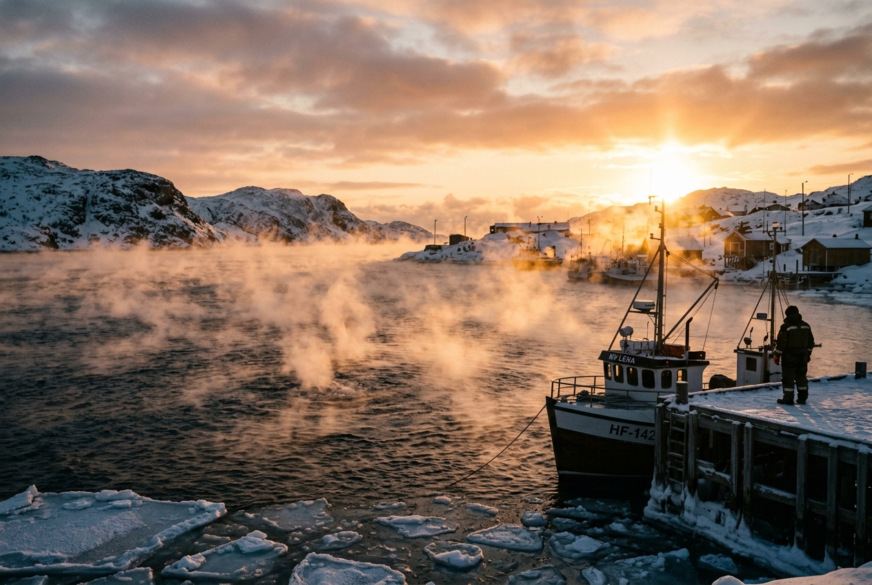
1. Opening Scene: The Boiling Sea
Standing upon the granite bluffs of a northern coastline at dawn, the world is reduced to sensory extremes. The mercury in your thermometer has plummeted to $-22^\circ\text{C}$, driven downward by an unrelenting, baroclinic gale screaming straight out of the polar interior. Every breath pulled into the lungs feels like inhaling pulverized glass; the moisture lining your nostrils crystallizes instantly into delicate lattices of frost. Your eyelashes freeze together at each blink, and the dry, metallic scent of ozone and desiccated arctic air dominates the senses.
Yet, looking out past the jagged rim of shore ice, the open water of the sound presents an astonishing paradox: it appears to be boiling furiously.
       ARCTIC AIR MASS (Bitter cold, dry: -20°C)
  ~~~~~~~~~~~~~~~~~~~~~~~~~~~~~~~~~~~~~~~~~~~~~~~~~~~~~
    \   \   \   \   \   \   \   \   \   \   \   \   \
     v   v   v   v   v   v   v   v   v   v   v   v   v
  -----------------------------------------------------
  ^   ^   ^   ^   ^   ^   ^   ^   ^   ^   ^   ^   ^   ^
  |   |   |   |   |   |   |   |   |   |   |   |   |   |  Rising "Steam" Plumes
  |   |   |   |   |   |   |   |   |   |   |   |   |   |  (Micro-Convection)
  =====================================================
     WARM, UNFROZEN WATER SURFACE (+4°C Liquid Ocean)
Across the dark, iron-grey surface of the sea, dense tendrils of luminous white vapor writhe and twist like the breath of a thousand subterranean furnaces. Unlike the quiet, stagnant blankets of autumn river fogs, this mist is alive with frantic kinetic energy. Wisps of condensation detach from the water, shooting upward in turbulent ribbons several meters high before vanishing into the bone-dry sky. In places where the wind shears across the wave crests, the vapor gathers into spinning, ethereal columns—miniature aquatic tornadoes, known as steam devils, that corkscrew across the water before being torn apart by the gale.
The sea is not boiling at all; the water temperature is barely $+2^\circ\text{C}$ or $+4^\circ\text{C}$. But to the human eye, the illusion is total. You are witnessing sea smoke—variously termed steam fog, frost smoke, or evaporation fog—one of the most visually dramatic manifestations of atmospheric thermodynamics on Earth.
2. What Is Actually Happening: Plain English First
To understand why water that is barely above freezing can look like a simmering kitchen kettle, we must dismantle a common intuition about how clouds and fog form.
Most people understand that fog appears when air cools down to its condensation point—often called the dew point. When warm, humid air glides over a cold meadow on an autumn night, it loses heat, shivers, and drops its moisture as a low-slung cloud. But sea smoke operates through the exact opposite mechanism: it forms when dry, freezing air is heated and humidified simultaneously from below.
Think of the atmosphere as a layered cake, where each layer possesses a distinct temperature and an appetite for water vapor. Air's capacity to hold invisible water vapor is strictly governed by its temperature. Warm air has an enormous appetite; cold air can hold almost none.
Now, imagine holding a freshly poured, steaming cup of black coffee outside on a bitter sub-zero morning. The coffee is liquid, warm, and constantly evaporating moisture into the ultra-thin air right above the mug. As that warm, moisture-saturated air rises just a millimeter into the frigid ambient atmosphere, the two air parcels violently mix.
+-------------------------------------------------------------------------+
|                      THE ISO-BARIC MIXING PARADOX                       |
|                                                                         |
|  Warm, Moist Surface Air        Frigid, Dry Ambient Air                 |
|  (Holds a lot of water vapor)   (Holds almost zero water vapor)         |
|                 \                         /                             |
|                  \                       /                              |
|                   -->   THE MIXTURE   <--                               |
|                                                                         |
|        Temperature = Arithmetic Average (Intermediate Cold)             |
|        Moisture    = Arithmetic Average (Substantial Vapor)             |
|                                                                         |
|  CRITICAL OUTCOME: The intermediate cold temperature CANNOT hold        |
|  that average moisture. The excess MUST condense as visible fog!        |
+-------------------------------------------------------------------------+
When you blend equal parts of hot, humid air and freezing, dry air, the resulting mixture sits at an intermediate temperature. However, because cold air's ability to hold vapor drops off drastically compared to warm air, the combined moisture content of the mixture exceeds the air’s physical holding capacity. The air is suddenly overloaded with more vapor than its new, blended temperature can tolerate.
The atmosphere instantly sheds this excess vapor, condensing it into billions of microscopic liquid droplets suspended in the air. Over the open ocean or a Great Lake, this process occurs across millions of square meters simultaneously, creating an endless, smoking cauldron.
Furthermore, because warm air is lighter and more buoyant than cold air, the thin slice of air resting immediately against the water becomes intensely buoyant. It blasts upward like miniature hot-air balloons, creating the boiling, turbulent plumes that give sea smoke its distinctive, ragged appearance.
3. The Science: Thermodynamics, Non-Linearity, and Micro-Convection
To move from intuition to mathematical rigor, we must examine the thermodynamic state variables governing the air-sea boundary layer.
The Non-Linear Engine: The Clausius-Clapeyron Relation
The physical foundation of sea smoke rests upon the Clausius-Clapeyron equation, which describes the phase equilibrium between liquid water and its vapor. In atmospheric science, this is expressed through the saturation vapor pressure $e_s(T)$—the partial pressure of water vapor when the air is in complete thermodynamic equilibrium with a flat surface of pure liquid water at temperature $T$.
A widely accepted and highly accurate approximation is the Magnus-Tetens formula:
$$e_s(T) = 6.112 \exp\left(\frac{17.67 \, T}{T + 243.5}\right)$$
Where $T$ is the temperature in degrees Celsius ($^\circ\text{C}$), and $e_s(T)$ is the saturation vapor pressure in hectopascals ($\text{hPa}$).
The crucial mathematical property of this function is its strict convexity ($\frac{d^2 e_s}{dT^2} > 0$). The saturation vapor pressure curve bends steeply upward as temperature increases:
 Vapor Pressure (hPa)
   ^                                          e_s(T) Saturation Curve
   |                                               ...--- S (Water Skin)
   |                                         ..---
   |                             M (Mixture)x
   |                          ..---        /
   |                   ..---              /  Straight Mixing Chord
   |            ..---                    /
   |     ..---                          /
   |  .-                               /
   | A (Ambient Arctic Air)           /
   +------------------------------------------------------------->
                                                          Temp (°C)
   NOTE: Point M lies ABOVE the saturation curve, in the supersaturated zone!
When two distinct air parcels mix isobarically (at constant atmospheric pressure) without external heat exchange, the resulting mixture's temperature $T_{\text{mix}}$ and actual vapor pressure $e_{\text{mix}}$ follow simple linear weighted averages:
$$T_{\text{mix}} = f T_{\text{skin}} + (1 - f) T_{\text{air}}$$ $$e_{\text{mix}} = f e_{\text{skin}} + (1 - f) e_{\text{air}}$$
Where $f$ represents the mass mixing fraction ($0 \le f \le 1$).
On a psychrometric chart or $e$-$T$ graph, this linear mixing trajectory forms a straight chord connecting the environmental state of the ambient arctic air $(T_{\text{air}}, e_{\text{air}})$ to the maritime surface skin layer $(T_{\text{skin}}, e_{\text{skin}})$.
Because the saturation vapor pressure curve $e_s(T)$ is concave upward (convex), the straight line connecting these two points must pass above the curve across a wide band of mixing ratios. Consequently:
$$e_{\text{mix}} > e_s(T_{\text{mix}})$$
This condition defines supersaturation ($S = \frac{e_{\text{mix}}}{e_s(T_{\text{mix}})} > 1.0$). The atmosphere cannot sustain this excess vapor without condensation. Droplet nucleation occurs immediately on ambient condensation nuclei, generating the dense mist of steam fog.
Worked Thermodynamic Example
Let us apply real-world meteorological observations recorded during a severe arctic air outbreak over the northern Atlantic:
- Water Surface Skin ($T_{\text{skin}}$): $+4.0^\circ\text{C}$, completely saturated ($RH = 100\%$).
- Arctic Air Mass ($T_{\text{air}}$): $-20.0^\circ\text{C}$, unsaturated with a relative humidity ($RH$) of $70\%$.
Step 1: Calculate the Saturation Vapor Pressure at the Water Surface
$$e_{\text{skin}} = e_s(+4.0) = 6.112 \exp\left(\frac{17.67 \times 4.0}{4.0 + 243.5}\right) = 6.112 \exp(0.28557) \approx 8.132 \, \text{hPa}$$
Step 2: Calculate the Ambient Air's Actual Vapor Pressure
First, compute the saturation vapor pressure at $-20.0^\circ\text{C}$: $$e_s(-20.0) = 6.112 \exp\left(\frac{17.67 \times (-20.0)}{-20.0 + 243.5}\right) = 6.112 \exp(-1.5812) \approx 1.256 \, \text{hPa}$$ With $RH = 70\%$, the actual ambient vapor pressure is: $$e_{\text{air}} = 0.70 \times 1.256 \, \text{hPa} \approx 0.879 \, \text{hPa}$$
Step 3: Mix the Two Parcels (Assume an Equal 50/50 Mass Ratio, $f = 0.5$)
$$T_{\text{mix}} = 0.5(4.0) + 0.5(-20.0) = -8.0^\circ\text{C}$$ $$e_{\text{mix}} = 0.5(8.132) + 0.5(0.879) = 4.506 \, \text{hPa}$$
Step 4: Determine the Saturation Limit at the Mixture Temperature
$$e_s(-8.0) = 6.112 \exp\left(\frac{17.67 \times (-8.0)}{-8.0 + 243.5}\right) = 6.112 \exp(-0.60025) \approx 3.354 \, \text{hPa}$$
Step 5: Evaluate Supersaturation
$$\Delta e = e_{\text{mix}} - e_s(T_{\text{mix}}) = 4.506 - 3.354 = +1.152 \, \text{hPa}$$ $$\text{Relative Humidity of Mixture} = \left(\frac{4.506}{3.354}\right) \times 100\% = 134.3\%$$
The mixture is supersaturated by over $34\%$. This massive excess vapor pressure of $1.152\text{ hPa}$ forces instantaneous condensation into liquid water droplets.
Sensible and Latent Heat Fluxes: The Bulk Aerodynamic Formulation
The second pillar of sea smoke dynamics is the massive transfer of energy across the air-water interface. The extreme temperature gradient creates colossal vertical sensible heat fluxes ($H$) and latent heat fluxes ($LE$).
According to the bulk aerodynamic formulation utilized by the National Oceanic and Atmospheric Administration (NOAA):
$$H = \rho \, c_p \, C_H \, U_{10} \, (T_{\text{skin}} - T_{\text{air}})$$
Where: * $\rho \approx 1.38 \, \text{kg m}^{-3}$ (density of dry arctic air at $-20^\circ\text{C}$) * $c_p = 1005 \, \text{J kg}^{-1} \text{K}^{-1}$ (specific heat capacity of dry air) * $C_H \approx 1.5 \times 10^{-3}$ (dimensionless turbulent bulk transfer coefficient for heat) * $U_{10} = 12.0 \, \text{m s}^{-1}$ (wind speed measured at the standard $10\text{-meter}$ height, roughly $24\text{ knots}$) * $\Delta T = T_{\text{skin}} - T_{\text{air}} = 4.0 - (-20.0) = 24.0 \, \text{K}$
Plugging in these values:
$$H = 1.38 \times 1005 \times (1.5 \times 10^{-3}) \times 12.0 \times 24.0 \approx 599.2 \, \text{W m}^{-2}$$
When combined with the accompanying latent heat flux ($LE \approx 350\text{--}500\text{ W m}^{-2}$), the total upward heat flux routinely exceeds $1,000 \, \text{W m}^{-2}$. To put this in perspective, this energy transfer rivals or exceeds the peak solar irradiance received at the equator at solar noon. The ocean is literally venting its thermal reserves directly into the atmospheric boundary layer.
+-------------------------------------------------------------------------+
|             BULK HEAT FLUX SUMMARY: ARCTIC OUTBREAK OVER WATER          |
|                                                                         |
|   Sensible Heat Flux (H) :  ~600 W/m² (Direct conduction & convection)  |
|   Latent Heat Flux (LE)  :  ~400 W/m² (Phase change via evaporation)    |
|   --------------------------------------------------------------------  |
|   Total Energy Release   : >1,000 W/m² (Surpassing equatorial sunshine) |
+-------------------------------------------------------------------------+
Micro-Convection, Plumes, and Steam Devils
This violent heat flux fundamentally destabilizes the lowest millimeters of the atmosphere.
In a standard atmospheric profile, warm air overlies cold air, creating static stability. In the sea smoke environment, dense, frigid air sits directly atop a warm boundary layer. The local environmental lapse rate ($-\frac{\partial T}{\partial z}$) in the lowest few centimeters becomes wildly superadiabatic, triggering intense Rayleigh-Bénard convection.
    ^  Height (z)
    |
    |      Cold, dense air sinking
    |         |           |
    |         v           v
    |       +---+       +---+
    |       |   |       |   |       Turbulent Plumes & Thermal Chimneys
    |       ^   ^       ^   ^       (Rising buoyant, saturated air)
    |      /     \     /     \
    +=====/=======\===/=======\=======================================>
        WARM OCEAN SURFACE (Skin Layer: High Vapor Pressure & Buoyancy)
The air organizes into ascending thermal plumes—narrow, turbulent chimneys of warm, moisture-laden air. As these plumes rise, they shear against the descending cold air, generating localized vertical vorticity ($\zeta = \frac{\partial v}{\partial x} - \frac{\partial u}{\partial y}$).
When strong horizontal wind shear interacts with these thermal updrafts, the localized vortices are dynamically stretched along the vertical axis via vortex stretching ($\omega_z \frac{\partial w}{\partial z}$). Conservation of angular momentum spins these filaments up into rotating, concentrated vortices: steam devils. These features operate precisely like aquatic dust devils, drawing rotating cylinders of dense white condensation up to heights of 10 to 30 meters.
Fog Taxonomy: Sea Smoke vs. Radiation Fog vs. Advection Fog
To appreciate the thermodynamic singularity of sea smoke, it is useful to contrast it against the other primary fog mechanisms cataloged by the World Meteorological Organization (WMO):
| Fog Classification | Thermodynamic Mechanism | Boundary Layer Stability | Typical Appearance & Behavior |
|---|---|---|---|
| Sea Smoke (Evaporation Fog) | Cold, dry air flows over warm water; heated & humidified from below via non-linear mixing. | Extremely Unstable (Superadiabatic surface layer; convective plumes). | Dynamic, boiling, wispy plumes; steam devils; shallow vertical extent (1–30 m). |
| Radiation Fog | Ground cools radiatively on clear, calm nights; air cools from below to its dew point. | Strongly Stable (Surface-based temperature inversion; stagnant air). | Uniform, smooth, flat blanket; zero vertical convective motion; quiet. |
| Advection Fog | Warm, moist air mass glides horizontally across a cold surface (ocean or snowpack). | Strongly Stable (Cooling from below; capped by inversion). | Dense, deep, persistent layer; sweeping horizontally with wind; non-convective. |
                    COMPARATIVE BOUNDARY LAYER PROFILES

SEA SMOKE (Unstable)         RADIATION FOG (Stable)      ADVECTION FOG (Stable)

        Cold Air                      Warm Air                    Warm Air
           |                             |                           |
           v                             v                           v
     [Superadiabatic]             [Surface Inversion]         [Advection Inversion]
           ^                             ^                           ^
           |                             |                           |
       Warm Water                    Cold Ground                  Cold Water
While advection fog and radiation fog require a tranquil, stable temperature inversion to prevent mixing and allow cooling, sea smoke requires intense turbulent mixing and thermal instability to exist.
Synoptic Prevalence: Polynyas, Shipping Lanes, and the Laurentian Lakes
Sea smoke is not a random curiosity; it is a vital synoptic indicator in polar and sub-polar climatology.
       +-------------------------------------------------------------+
       |           GLOBAL HOTSPOTS FOR EVAPORATION FOG DYNAMICS      |
       +-------------------------------------------------------------+
       | 1. High-Latitude Polynyas (Arctic & Antarctic ice openings) |
       | 2. North Atlantic Shipping Lanes (Labrador Sea, Irminger)   |
       | 3. Laurentian Great Lakes (Superior & Michigan in January)  |
       +-------------------------------------------------------------+
- High-Latitude Polynyas: In the Arctic and Antarctic, persistent offshore winds push pack ice away from coastlines or ice shelves, exposing open water known as polynyas (such as the North Water Polynya in Baffin Bay). When $-40^\circ\text{C}$ katabatic winds tumble off ice sheets across $-1.8^\circ\text{C}$ polar seawater, sea smoke forms on a colossal scale, driving massive atmospheric modification and deep oceanic convective overturning that powers the global thermohaline circulation.
- North Atlantic Shipping Lanes: In the Labrador Sea and Norwegian Sea, winter maritime cyclones pull continental polar air masses off Greenland and North America across the warm North Atlantic Drift. The resulting steam fog creates severe maritime navigational hazards, severely degrading visibility and coating ship superstructures in perilous rime ice.
- The Laurentian Great Lakes: During mid-winter polar vortex intrusions across North America, unfrozen areas of Lake Superior, Lake Michigan, and Lake Huron experience prolonged sea smoke events. The immense upward moisture flux serves as the moisture nursery for downwind lake-effect snow bands that dump meters of snow on coastal communities.
4. Practical Outdoor Guidance: The Observer's Field Guide
For mariners, coastal hikers, photographers, and field scientists, sea smoke offers an accessible laboratory for boundary-layer meteorology.
+-------------------------------------------------------------------------+
|                  OUTDOOR OBSERVER'S SEA SMOKE CHECKLIST                 |
|                                                                         |
|  [ ] Water-Air Temperature Differential: ΔT ≥ 10°C (18°F)               |
|  [ ] Barometer: Rising or steady high post-cold-frontal passage         |
|  [ ] Wind Vector: Sustained offshore or continental arctic trajectory   |
|  [ ] Visual Indicator: Whispering thermal chimneys & steam devils       |
|  [ ] Hazard Awareness: Severe superstructure rime icing risk            |
+-------------------------------------------------------------------------+
1. What to Look for in the Sky and on the Water
- Thermal Plumes vs. Stratified Sheets: Look at the base of the fog layer. If the fog is forming a uniform, flat, motionless ceiling, you are looking at advection or radiation fog. If the fog consists of hundreds of vertical, dancing ribbons, thermal chimneys, and wisps that dissolve within 5 to 15 meters of the surface, you are observing evaporation fog.
- Steam Devil Rotation: Watch the wave troughs. When a strong gust shears past a rising plume, you will observe brief, cyclonically or anticyclonically rotating vortices tracking rapidly downwind.
- Optical Phenomena: Because sea smoke is composed of liquid water droplets at sub-freezing temperatures (supercooled water), direct low-angle morning sunlight can produce faint fog bows (white rainbows) or glory rings when looking down into the plumes from an elevated bluff.
2. Instrument Readings to Monitor
- The Critical $\Delta T$: Measure the temperature of the water surface (using an infrared thermometer or local buoy telemetry from the National Data Buoy Center) and compare it to the ambient air temperature at head height. Sea smoke rarely develops unless the water-to-air temperature differential ($\Delta T = T_{\text{water}} - T_{\text{air}}$) meets or exceeds $9^\circ\text{C}$ to $10^\circ\text{C}$ ($16^\circ\text{F}$ to $18^\circ\text{F}$). For violent, dense displays with steam devils, look for $\Delta T \ge 18^\circ\text{C}$ to $22^\circ\text{C}$.
- Barometric Pressure: Sea smoke almost universally occurs in the wake of a powerful cold front, characterized by rapidly rising barometric pressure followed by a strong, biting polar high-pressure ridge.
- Wind Direction and Speed: A moderate breeze between $4\text{ and }12\text{ m s}^{-1}$ (8 to 24 knots) generates the optimal wind shear required to mix the boundary layer while simultaneously organizing steam devils. If the wind is dead calm, the fog remains a very shallow, stagnant skin; if winds exceed storm force, the plumes are mechanically sheared apart before they can organize.
3. The Sailor’s and Outdoorsperson’s Rule of Thumb
The Arctic Freezing Spray Warning Rule: If sea smoke is actively boiling over open water and the air temperature is below $-10^\circ\text{C}$ ($14^\circ\text{F}$), any wind-driven sea spray colliding with a vessel hull or cold rock will freeze instantly into hard, clear glaze or dense rime.
For coastal navigators, the appearance of sea smoke is the ultimate warning sign that structural icing conditions have reached critical thresholds.
5. Today's Meteorological Rule of Thumb
=============================================================================
                     TODAY'S METEOROLOGICAL RULE OF THUMB
=============================================================================
  When the water is at least 10°C (18°F) warmer than the bitter wind sweeping
  across it, the arithmetic of vapor pressure demands condensation: two dry,
  unsaturated air parcels will always forge a supersaturated, smoking mist.
=============================================================================
The next time you stand before a smoking winter lake or an arctic fjord, remember that you are not looking at heat escaping by boiling. You are looking at the geometry of the Clausius-Clapeyron equation made visible: the physical inevitability of a non-linear atmosphere forced to balance its books in the frozen air.