Rotunno-Klemp-Weisman (RKW) Theory & Cold Pool Dynamics: How Baroclinic Vorticity Balance Sustains Long-Lived Squall Lines
1. Opening Scene: The Anatomy of an Approaching Tempest
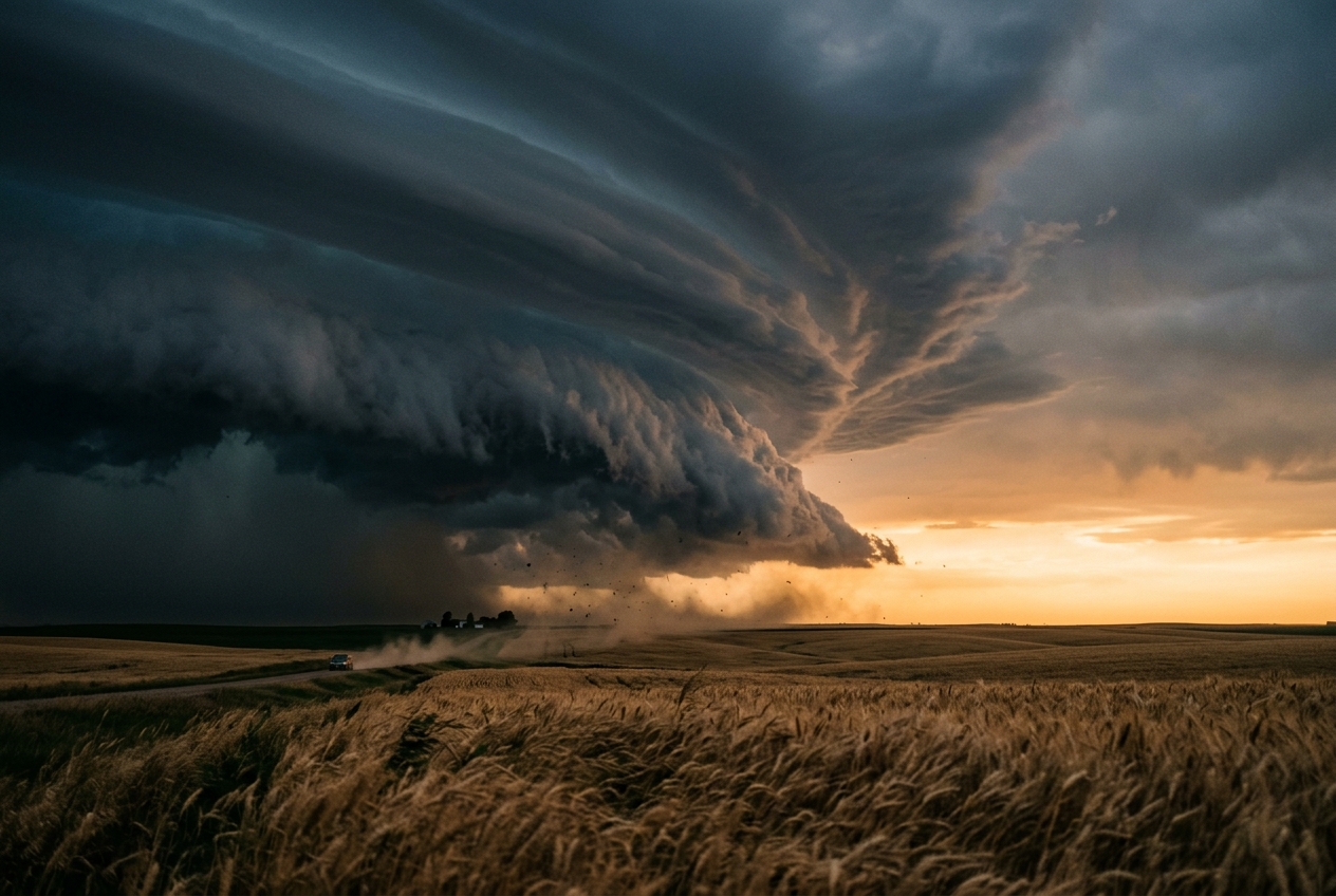
Stand upon an open expanse of prairie or coastal marshland on a sultry midsummer afternoon, and the atmosphere often feels thick enough to drink. The ambient air is suffocatingly warm—perhaps thirty-three degrees Celsius—laden with moisture evaporated from sun-baked soils and distant waterways. For hours, the sky has appeared static, punctuated only by the lazy, cauliflower-like bubbling of cumulus clouds drifting along the horizon. Yet within thirty minutes, the western sky transmutes from benign haze into an impenetrable, bruised rampart of slate and indigo.
As the feature approaches, an imposing horizontal arch forms at the cloud base: a shelf cloud, known technically as an arcus. Its underside is turbulent, sculpted into ragged, laminar tiers and churning folds that appear to scrape the treetops. A peculiar hush settles over the landscape. Birds cease their chorus; the gentle southerly breeze that sustained the afternoon’s swelter dies abruptly to absolute stillness.
Then comes the olfactory harbinger: the sharp, metallic, earthen scent of petrichor, mingled with ozone synthesized by distant intra-cloud lightning discharges.
Within seconds, the tranquil calm is obliterated. A violent, icy deluge of air strikes your face—not descending from directly overhead, but charging horizontally along the turf. The ambient temperature plummets by twelve degrees Celsius in less than ninety seconds. An aneroid barometer strapped to your wrist registers an immediate, anomalous spike of several hectopascals—the classic "pressure nose" or thunderstorm high. Trees violently bend away from the storm as wind gusts double and triple in velocity, carrying stinging dust and scattered, oversized raindrops.
You are standing on the front lines of one of the atmosphere’s most elegant physical confrontations: the leading edge of a convective cold pool, an advancing mesoscale density current locking horns with the ambient tropospheric wind field.
2. What’s Actually Happening: Gravity Currents, Sinking Air, and the Atmospheric Barrel-Roll
To understand why this violent curtain of cold air behaves as it does, we must strip away the storm's chaotic appearance and examine the fundamental thermodynamics of fluids.
Think of the lower atmosphere as an expansive reservoir filled with warm, relatively light water. When a severe thunderstorm matures, its upper reaches suck vast quantities of dry, mid-level environmental air into its precipitation core. As raindrops and hail fall through this dry layer, they partially evaporate and sublimate. Evaporation is an energetically expensive thermodynamic process; it extracts latent heat directly from the surrounding air molecules.
Chilled rapidly by this evaporative cooling, the air parcel becomes significantly denser and heavier than the pristine tropical air surrounding it. Laden with the physical drag of millions of falling hydrometeors, this dense pocket has only one option under the relentless pull of gravity: it accelerates violently downward toward the Earth’s surface as a downdraft.
Upon slamming into the rigid boundary of the ground, the descending air cannot penetrate the soil. Instead, it splashes radially outward, behaving exactly like a bucket of cold whole milk dumped across the surface of a warm swimming pool. Because the cold air is dense and viscous, it hugs the terrain, carving out a distinct, shallow wedge of high-pressure fluid known to meteorologists as a cold pool.
As this dense cold pool bulldozes forward across the countryside, it encounters the prevailing warm, moist air mass feeding the storm. Because the cold air is heavier, it wedges beneath the oncoming warm air, forcibly hoisting it skyward like a kinetic ramp. This forced mechanical lifting cools the warm air to its dew point, creating the dramatic shelf cloud that heralds the storm's arrival.
However, a critical mechanical dilemma arises. When dense air sits adjacent to light air along a horizontal plane, gravity pulls down harder on the dense side than on the light side. This differential pull creates a powerful horizontal rolling motion—a vortex—right at the leading edge of the cold pool.
If this cold-pool-generated barrel-roll goes unchecked, it will continually tumble backward over itself, dragging the newly lifted warm air back into the rain-soaked core of the cold pool. The updraft tilts backward, chokes on its own cold exhaust, and the thunderstorm rapidly dies.
How, then, do organized squall lines and linear storm complexes survive for hundreds of kilometers over six, twelve, or eighteen hours?
The answer lies in the wind structure of the surrounding environment: vertical wind shear. If the background winds change speed or direction with height, the environment possesses its own built-in horizontal roll—spinning in the exact opposite direction to the roll generated by the cold pool. When these two opposing mechanical spins collide, they can lock into a state of magnificent, self-sustaining equilibrium.
3. The Science: The Rotunno-Klemp-Weisman (RKW) Theory
In a landmark 1988 paper published in the Journal of the Atmospheric Sciences, atmospheric physicists Richard Rotunno, Joseph Klemp, and Morris Weisman formulated what is now universally celebrated as RKW Theory. Their mathematical framework quantified precisely how the balance between cold pool strength and low-level environmental shear determines the longevity, structure, and destructive potential of convective systems.
To appreciate the predictive power of RKW theory, we examine the system through two complementary mathematical lenses: fluid density propagation and horizontal vorticity balance.
Part A: Cold Pool Propagation Velocity
A cold pool behaves kinematically as an atmospheric gravity current. The theoretical speed $c$ at which the leading edge (the gust front) surges forward across flat terrain is dictated by the depth of the cold air and its negative buoyancy deficit relative to the undisturbed ambient environment.
Plain English Prediction
The speed of the advancing gust front increases directly with the square root of two factors: how deep the pool of cold air is, and how much colder (and therefore denser) it is compared to the surrounding air.
The Governing Formula
In continuous form, the theoretical propagation velocity $c$ across a cold layer of depth $H$ is expressed through the vertical integral of negative buoyancy:
$$c = \sqrt{2 \int_0^H (-B) \, dz}$$
Where $B$ is the buoyant acceleration defined via virtual potential temperature anomalies:
$$B = g \left( \frac{\theta_v'}{\bar{\theta}v} \right) = g \left( \frac{\theta{v,\text{cold}} - \theta_{v,\text{ambient}}}{\bar{\theta}_{v,\text{ambient}}} \right)$$
Assuming a well-mixed, vertically homogeneous cold pool layer of uniform depth $H$ and uniform temperature deficit $\Delta \theta_v$, the equation simplifies into the standard hydraulic density-current relationship:
$$c = \sqrt{2 \, g \, H \, \left( \frac{\Delta \theta_v}{\bar{\theta}_v} \right)}$$
Where: * $c$ is the theoretical propagation speed of the cold pool gust front ($\text{m s}^{-1}$). * $g$ is the acceleration due to gravity ($9.81 \text{ m s}^{-2}$). * $H$ is the depth of the cold pool outflow layer ($\text{m}$). * $\Delta \theta_v = \bar{\theta}v - \theta{v,\text{cold}}$ is the virtual potential temperature deficit of the cold pool ($\text{K}$). * $\bar{\theta}_v$ is the mean virtual potential temperature of the undisturbed environmental inflow layer ($\text{K}$).
Worked Physical Example
Consider a severe squall line traversing the Great Plains observed by the NOAA Storm Prediction Center. Surface mesonet stations and sounding data reveal: * Ambient low-level virtual potential temperature: $\bar{\theta}v = 305.0 \text{ K}$ ($\approx 32^\circ\text{C}$). * Cold pool core virtual potential temperature: $\theta{v,\text{cold}} = 297.0 \text{ K}$ ($\approx 24^\circ\text{C}$). * Temperature deficit: $\Delta \theta_v = 305.0 - 297.0 = 8.0 \text{ K}$. * Depth of the evaporatively cooled outflow layer: $H = 2,500 \text{ m}$.
We calculate the theoretical propagation speed $c$:
$$\frac{\Delta \theta_v}{\bar{\theta}_v} = \frac{8.0}{305.0} \approx 0.02623$$
$$c = \sqrt{2 \times 9.81 \text{ m s}^{-2} \times 2500 \text{ m} \times 0.02623}$$
$$c = \sqrt{49050 \times 0.02623} = \sqrt{1286.58} \approx 35.87 \text{ m s}^{-1}$$
Converting to operational units:
$$35.87 \text{ m s}^{-1} \times 3.6 = 129.1 \text{ km h}^{-1} \quad (\approx 80.2 \text{ mph} \text{ or } 69.7 \text{ knots})$$
This indicates an exceptionally aggressive, severe-tier density current capable of sustaining severe gale-force outflow winds at the leading edge.
Part B: The Horizontal Vorticity Balance Equation
The fundamental genius of RKW theory is recognizing that fluid speed alone does not govern convective longevity; rather, it is the contest between two competing sources of horizontal vorticity ($\eta$).
In a two-dimensional cross-section perpendicular to an advancing linear convective storm, horizontal vorticity $\eta$ is defined as the vertical shear of horizontal velocity minus the horizontal gradient of vertical velocity:
$$\eta = \frac{\partial u}{\partial z} - \frac{\partial w}{\partial x}$$
The prognostic equation for horizontal vorticity along the gust front is governed by advective and baroclinic source terms:
$$\frac{\partial \eta}{\partial t} = -\mathbf{u} \cdot \nabla \eta - \frac{\partial B}{\partial x}$$
Notice the final term: $-\frac{\partial B}{\partial x}$. Because buoyancy plummets as one crosses the boundary from the warm environment into the cold pool ($x$-direction), $\frac{\partial B}{\partial x}$ is strongly negative. Multiplied by the negative sign, this term acts as an intense positive generator of baroclinic horizontal vorticity.
This baroclinically generated spin acts to rotate parcels backwards over the cold pool.
Conversely, the ambient environment contains low-level vertical wind shear ($\Delta u$), measured over a depth comparable to the cold pool ($0\text{ to }d$, where $d \approx H$). The environmental shear contributes a vorticity of opposite sign:
$$\eta_{\text{shear}} = -\frac{\Delta u}{d} = -\frac{u(H) - u(0)}{H}$$
RKW theory synthesizes this interaction into the non-dimensional RKW Ratio: $\frac{c}{\Delta u}$.
The Three Kinematic Regimes of RKW Theory
| Regime | Mathematical Condition | Kinematic Behavior | System Longevity & Evolution |
|---|---|---|---|
| I. Shear-Dominated | $\frac{c}{\Delta u} < 1.0$ | Ambient shear overwhelms cold pool baroclinicity. Updraft is forced to tilt downshear (forward over the rain-free warm air). | Suboptimal & Ephemeral: Condensation products fall directly downshear into the inflow path, disrupting low-level thermodynamic destabilization. Cells remain disjointed. |
| II. Cold-Pool-Dominated | $\frac{c}{\Delta u} > 1.0$ | Cold pool baroclinic vorticity overwhelms ambient shear vorticity. Updraft tilts upshear (backward over the cold pool). | Decaying / Stratiform Transition: The gust front surges far ahead of the updraft, cutting off surface-based inflow. Updraft weakens, lifting occurs only along a trailing stratiform deck. |
| III. Optimal Balance | $\frac{c}{\Delta u} \approx 1.0$ | Baroclinically generated vorticity at the cold pool nose precisely cancels the environmental shear vorticity. | Maximized Vertical Ascent: Updraft ascends vertically ($90^\circ$ orientation), creating explosive condensation, continuous mid-level mass evacuation, and long-lived quasi-steady squall lines. |
$$c \approx \Delta u \implies \sqrt{2 \int_0^H (-B) \, dz} \approx u(H) - u(0)$$
When this optimal condition ($c / \Delta u \approx 1$) is sustained, the squall line does not require external synoptic forcing to survive. It behaves as a self-propagating dynamic machine, perpetually regenerating new deep convective cells along its forward flank as older cells decay toward the rear.
4. Operational Meteorology and Practical Outdoor Guidance
Operational meteorologists at forecasting agencies such as the Met Office and the World Meteorological Organization monitor the balance between environmental shear and cold pool strength when assessing the threat of severe weather complexes.
The Transition to Bow Echoes and Damaging Winds
When a cold pool becomes slightly dominant ($c/\Delta u > 1$), an important structural evolution frequently occurs: the formation of a bow echo.
As the updraft tilts upshear over the cold pool, a mid-level mesoscale low-pressure perturbation forms beneath the tilted convective plume. This mid-level pressure deficit draws dry environmental air inward from the rear of the storm at altitudes between 3 and 5 kilometers.
As this air encounters precipitation, evaporative cooling accelerates the stream downward toward the leading edge, creating a concentrated channel of high-momentum air known as the Rear Inflow Jet (RIJ).
When the Rear Inflow Jet reaches the surface, it distorts the linear squall line into a prominent bow shape. At the northern and southern flanks of this bow, counter-rotating vortices—known as bookend vortices—develop. The cyclonic vortex on the northern flank compresses the local pressure gradient, funneling the most devastating straight-line winds directly through the apex of the bow. Forecasters inspecting Doppler velocity fields on the National Weather Service radar network treat these bowing segments as indicators of impending wind damage and potential brief mesovortices.
What to Observe in the Field
For mariners, mountaineers, aviators, and keen sky-watchers, understanding cold pool dynamics transforms an intimidating storm into a readable physical system.
                          FIELD OBSERVATION MATRIX

   EYES ON THE SKY             BAROMETER TRACE             ANEMOMETER & THERMOMETER

   Smooth, striated arcus      Sharp pressure jump         Instantaneous wind shift
   moving steadily ahead       (2 to 5 hPa rise)           and steep temperature drop
   of precipitation core       coinciding with the         coincident with shelf-cloud
   indicates balanced,         gust front passage.         passage overhead.
   severe-tier squall line.
1. Sky Visual Signatures
- The Smooth, High-Based Shelf Cloud: Indicates a balanced or slightly shear-dominated system ($c \le \Delta u$). The storm is ingesting warm air efficiently; severe lightning, hail, and strong updrafts are ongoing.
- A Ragged, Low, Rapidly Advancing Shelf Cloud Outrunning Rain: Signifies a cold-pool-dominated outflow ($c > \Delta u$). The gust front has detached from the main rain core. Damaging horizontal winds are imminent, but the convective updrafts behind it may begin choking on their own outflow.
- Roll Clouds (Volutus): A detached horizontal tube cloud rolling forward indicates that the cold pool's leading vortex has fully decoupled from the parent cloud base, signaling an advancing outflow boundary.
2. Surface Instrument Arrays
- Barometric Signature: Watch for the classic thunderstorm pressure jump. A rapid surge of $+2.0\text{ to }+6.0\text{ hPa}$ within five minutes confirms the arrival of the cold pool's high-density mass center.
- Thermometer and Hygrometer: The dew-point depression (temperature minus dew point) reveals evaporative potential. A large surface dew-point depression prior to storm arrival creates conditions for strong negative buoyancy and severe outflow speeds.
- Wind Veering / Backing: An abrupt veer of wind direction (e.g., from south-southwesterly ambient inflow to west-northwesterly outflow) paired with an instant tripling of velocity marks the precise passage of the density current nose.
3. Outdoor Operational Safety Rules
- The Gust Front Distance Rule: The shelf cloud represents the physical boundary of the cold pool, not the onset of rain. Damaging straight-line winds consistently precede the rain core by two to eight kilometers. If the shelf cloud is directly overhead, you are already inside the density current's turbulent mixing zone.
- The Barometric Trend for Mariners: If a falling barometric trend suddenly reverses into an explosive, sharp upward spike while the sky is dark to the windward horizon, drop canvas or seek shelter immediately; the density current boundary is within three to five minutes of impact.
- The American Meteorological Society Safety Paradigm: When convective lines maintain a vertically erect shelf cloud without ragged separation, assume the presence of optimal shear-cold pool balancing ($c/\Delta u \approx 1$) capable of generating continuous severe convective wind gusts exceeding 25 meters per second.
5. Summary of Core Meteorological Dynamics
By viewing linear storm systems not as chaotic outbursts of nature, but as fluid-mechanical engines regulated by the equilibrium between buoyancy-driven cold pools and sheared wind fields, researchers and forecasters can decode the lifecycle of the atmosphere's most magnificent storms.
Today’s Meteorological Rule of Thumb
The RKW Golden Rule of Storm Longevity:
A squall line survives not by the heat of its environment alone, but by the symmetry of its struggle: when the forward push of its rain-cooled cold pool perfectly matches the horizontal roll of the incoming wind shear ($c/\Delta u \approx 1$), the storm stands straight, breathes deep, and marches across continents.