Pyrocumulonimbus Dynamics & Fire-Driven Convection: How Intense Sensible Heat Fluxes and Smoke Aerosols Spawn Stratospheric Chimneys
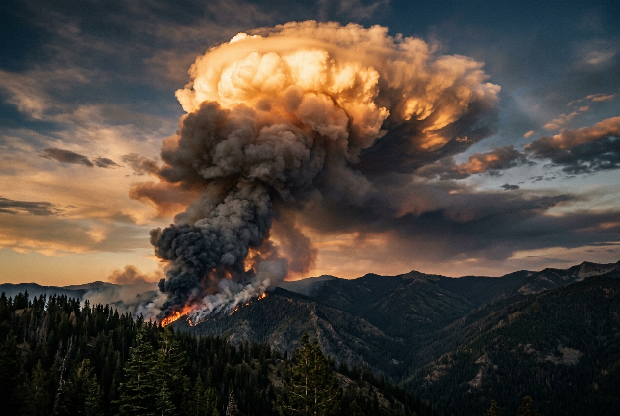
1. Opening Scene: The Horizon That Swallowed the Sun
The midday heat in the high backcountry does not merely warm the skin; it radiates off the baked granite and dry pine needles like the open door of an industrial kiln. The air has the brittle, resinous scent of vaporized terpenes—the volatile organic compounds cooked out of millions of desiccated eucalyptus and conifer needles under a cloudless, bronze-tinted sky. At first, the wind is deceptively light, wandering in fitful puffs across the ridgeline. But as you stand on the exposed crest, the atmosphere undergoes a subtle, unnerving mutation.
                                  [ STRATOSPHERE ]
                     - - - - - - - - - - - - - - - - - - - - - - -  Tropopause (~12-16 km)
                                    /           \
                                  /   OVERSHOOT   \
                                 /     ANVIL       \
                                /  (Glaciated Ice)  \
                               /_____________________\
                                       |  |  ^
                                       |  |  |  Supercooled Updraft
                                       |  |  |  (w_max > 50 m/s)
                       FREEZING LEVEL -|- -|- - - - - - - - - - - - 0°C (~4-5 km)
                                       |  |  |
                                       |  |  |  Suppressed Warm Rain
                                       |  |  |  (Smoke-Choked CCN)
                                      /      \
                                     /  LCL   \
                     - - - - - - - - - - - - - - - - - - - - - - -  Condensation Level (~2-3 km)
                                    /          \
                                   /  PYRO-PLUME \
                                  /   BUOYANCY    \
                                 /      FLUX       \
                     ___________/___________________\___________
                               ( MEGA-WILDFIRE FRONT )
                              Sensible Heat Flux (Q_H)
The ambient pressure drops with an abrupt, physical weight that registers inside your eardrums. The air rushing across the ridge reverses direction, accelerating from a gentle breeze into an aggressive, sucking inflow that pulls dry grit and pine cones directly toward a dark column boiling over the southern horizon. What began as a dull smudge of brownish wildfire smoke has curdled into something monstrous: an enormous, violently churning cauliflower stalk that towers tens of thousands of feet into the upper troposphere.
As the column expands, its summit transforms from dirty soot-grey to an incandescent, blinding white. A smooth, silk-like hood—a pileus cloud—momentarily crowns the rising dome before being obliterated by the sheer kinetic force of the rising column beneath it. The sun is blotted out, replaced by an apocalyptic amber twilight. High above, the cloud flattens and shears outward into a vast, bruised-violet anvil that spans the horizon from edge to edge.
Then comes the chill. The stifling 40°C heat is suddenly displaced by a violent, freezing downdraft slamming into the valley floor. The wind screams with a low acoustic roar, smelling intensely of ozone, charred wood, and wet ash. Dry lightning—forks of cobalt-blue electrical discharge with no accompanying rain—rips through the soot-laden sky, striking dry ridges miles ahead of the fire line. The wildfire is no longer merely burning across the landscape; it has generated its own storm system. You are standing in the shadow of a pyrocumulonimbus: nature’s most extreme thermodynamic collision between terrestrial combustion and atmospheric dynamics.
2. What's Actually Happening — Plain English First
To understand how a forest fire can morph into a continent-spanning thunderstorm, one must first dismantle the traditional view of thunderstorm formation. Under normal meteorological conditions, a thunderstorm is born when the sun bakes the Earth's surface, warming a pocket of moist air near the ground. Because warm air is less dense than the cold air above it, this pocket rises—much like a hot-air balloon. As it climbs, it expands and cools. Eventually, the invisible water vapor inside condenses into liquid droplets, forming a cloud. If the atmosphere is sufficiently unstable, this buoyant rising column accelerates, forming a towering cumulonimbus cloud.
In a mega-wildfire, the basic engine is identical, but the throttle has been smashed through the floorboards.
Think of the atmosphere as a vast, layered cake. Each layer has a specific temperature, pressure, and moisture content. Normally, a layer of warm, dry air sitting a few thousand feet up—known to meteorologists as a "temperature inversion"—acts like a sturdy glass ceiling. It prevents ordinary thermals from rising very high, capping cloud growth and keeping the weather calm.
NORMAL CONVECTION vs. PYROCUMULONIMBUS CONVECTION

NORMAL CUMULUS                      PYROCUMULONIMBUS (PyroCb)
   (Weak, Solar-Driven Thermal)            (Intense, Fire-Driven Engine)

Tropopause (Inversion)                  Tropopause Penetration
   ============================            ============================
                                                      /^^^^^^\
                                                     /  ANVIL \  --> Stratospheric
                                                    /__________\     Injection
                                                        |  ^
              Weak Cloud                                |  | Supercharged
                 (~~)                                   |  | Latent Heat of Fusion
                  ||                                    |  | (Explosive Freezing)
                  ||                                    |  |
   - - - - - - - -|| - - - - -             - - - - - - -| -|- - - - - - - -
           Inversion Cap                                |  | Pierces Inversion
                  ||                                    |  |
            Solar Heating                       Combustion Heat + Moisture
           ~~~~~~~~~~~~~~~                     =============================
           [ Gentle Sun ]                             [ MEGAFIRE FRONT ]
A megafire acts as an atmospheric battering ram. The intense combustion of dense forest fuels releases a gargantuan quantity of energy known as sensible heat flux ($Q_H$)—the direct, raw heat you feel when standing near a bonfire, multiplied across tens of thousands of hectares. This concentrated thermal energy superheats the air immediately above the flames to hundreds of degrees Celsius, creating an extraordinary density deficit relative to the surrounding atmosphere. The resulting buoyant plume accelerates upward with such violent momentum that it punches straight through the temperature inversion cap as if it were tissue paper.
Simultaneously, combustion creates its own water. The fundamental chemistry of burning organic cellulose—whether pine wood, chaparral, or eucalyptus—is a reaction between hydrocarbons and oxygen:
$$\left(\mathrm{C}6\mathrm{H}{10}\mathrm{O}_5\right)_n + 6n\mathrm{O}_2 \longrightarrow 6n\mathrm{CO}_2 + 5n\mathrm{H}_2\mathrm{O} + \text{Thermal Energy}$$
For every ton of dry wood consumed by the fire, approximately half a ton of water vapor is generated and injected directly into the core of the rising thermal plume. This combustion moisture, combined with the ambient water vapor pulled in by the fire’s gale-force surface winds, supercharges the air column with humidity.
Because the air in the plume is saturated with pyrogenic moisture, it does not have to rise as far before its water vapor condenses into cloud droplets. In atmospheric terminology, the Lifting Condensation Level (LCL)—the base of the cloud—is lowered, while the Level of Free Convection (LFC)—the altitude above which the air becomes warmer than its surroundings and accelerates upward on its own—is drastically depressed. Once the plume crosses this threshold, it ceases to be a mere smoke plume; it becomes a self-sustaining convective monster classified by the World Meteorological Organization (WMO) International Cloud Atlas as Cumulonimbus flammagenitus, colloquially known as a pyrocumulonimbus or PyroCb.
The ultimate secret to a PyroCb’s explosive violence, however, lies in its microphysics—the microscopic war between smoke particles and water droplets.
In a pristine thunderstorm, water vapor condenses onto a modest number of dust or salt particles in the air, known as Cloud Condensation Nuclei (CCN). Because there are relatively few CCN, each droplet can gather plenty of water, growing large and heavy. These droplets collide, merge (coalesce), and quickly fall out of the cloud as heavy rain. This falling rain creates a cold downdraft that acts as an internal brake, cooling the updraft and eventually choking off the storm.
In a PyroCb, the air is choking on trillions of microscopic carbon and aerosol particles. The available water vapor is divided among billions of competing nuclei. Instead of forming a moderate number of large, heavy raindrops, the cloud creates an ultra-dense fog of billions of microscopic, hyper-fine droplets.
These tiny droplets are too light to fall against the updraft. The normal rainmaking process—collision and coalescence—is completely suppressed. Because no rain falls to drag down the air or cool the lower plume, the updraft remains unhindered, accelerating skyward at highway speeds.
When this smoke-choked column surges past the freezing point ($0^\circ\text{C}$) and into the high-altitude sub-zero realm (down to $-40^\circ\text{C}$), these tiny water droplets remain liquid in a supercooled state until they suddenly and violently freeze all at once into ice crystals. This catastrophic, synchronized phase change releases an immense surge of latent heat of fusion ($L_f$), supercharging the core updraft like an atmospheric afterburner and rocketing the top of the cloud past the tropopause straight into the stratosphere.
3. The Science (For Those Who Want to Go Deeper)
To characterize the thermodynamic and kinetic behavior of fire-driven convective systems, atmospheric physicists model the plume as a buoyant, turbulent jet modified by pyrogenic enthalpy and moisture fluxes.
+--------------------------------------------------------------------------------+
|               KEY THERMODYNAMIC & KINETIC EQUATIONS OF PYROCBs                 |
|                                                                                |
|  1. Plume Buoyancy Flux:                                                       |
|                        g * Q_H                                                 |
|                   F = ---------   [m^4 / s^3]                                  |
|                       rho*cp*T_0                                               |
|                                                                                |
|  2. Maximum Updraft Velocity:                                                  |
|                   w_max = sqrt( 2 * CAPE_fire )   [m / s]                      |
+--------------------------------------------------------------------------------+
Equation 1: Plume Buoyancy Flux ($F$)
The primary engine of the initial convective column is the buoyancy flux ($F$), which quantifies the rate at which thermal energy from the surface fire front is converted into buoyant acceleration within the fluid atmosphere.
$$F = \frac{g \cdot Q_H}{\rho \cdot c_p \cdot T_0}$$
- What it predicts in plain English: This formula calculates the pure kinetic lifting power injected into the atmosphere per second by the fire’s heat output. It tells us how vigorously the fire can launch air upward before condensation even begins.
- The variables:
- $g = 9.81\,\text{m/s}^2$ is the acceleration due to gravity.
- $Q_H$ is the total convective sensible heat flux integrated across the flaming zone, measured in Watts ($\text{W}$ or $\text{J/s}$).
- $\rho$ is the ambient air density at surface level ($\approx 1.15\,\text{kg/m}^3$ at warm ground temperatures).
- $c_p$ is the specific heat capacity of dry air at constant pressure ($1005\,\text{J/(kg}\cdot\text{K)}$).
- $T_0$ is the ambient reference environmental temperature in Kelvin ($\text{K}$).
Worked Example: A Wildfire Plume Buoyancy Flux
Consider an extreme wildfire front spanning a flaming line with an integrated convective heat output of $Q_H = 5.0 \times 10^7\,\text{kW} = 5.0 \times 10^{10}\,\text{W}$ (a plausible value for an intense crown fire consuming heavy eucalyptus or timber fuels across several thousand meters of active fire front). Let the ambient surface temperature be $37^\circ\text{C}$ ($T_0 = 310.15\,\text{K}$) and air density $\rho = 1.15\,\text{kg/m}^3$.
Plugging these values into the buoyancy flux equation:
$$F = \frac{9.81 \times (5.0 \times 10^{10})}{1.15 \times 1005 \times 310.15}$$
Evaluating the denominator: $$\text{Denominator} = 1.15 \times 1005 \times 310.15 = 358{,}455.86\,\text{J/m}^3$$
Evaluating $F$: $$F = \frac{4.905 \times 10^{11}}{3.58456 \times 10^5} \approx 1.368 \times 10^6\,\text{m}^4\text{/s}^3$$
A buoyancy flux exceeding $10^6\,\text{m}^4/\text{s}^3$ represents an extraordinarily violent convective force. By comparison, typical agricultural burns or moderate prescribed fires exhibit buoyancy fluxes on the order of $10^2$ to $10^4\,\text{m}^4/\text{s}^3$. This enormous rate of buoyant energy injection accelerates the column through the planetary boundary layer within minutes, entraining surrounding air and creating a rigid vertical chimney.
Thermodynamic Modification: Soundings, $\theta_v$, and $\text{CAPE}_{\text{fire}}$
Once the buoyant plume ascends, ambient thermodynamic soundings (plotted on standard Skew-T Log-P diagrams) are modified by two primary fire-induced mechanisms:
-
Virtual Potential Temperature ($\theta_v$) Perturbation: The virtual potential temperature accounts for the density effects of both sensible temperature anomalies ($\Delta T$) and pyrogenic water vapor mixing ratio anomalies ($\Delta r_v$): $$\theta_v = \theta \left(1 + 0.61 r_v - r_L\right)$$ where $\theta$ is potential temperature, $r_v$ is water vapor mixing ratio, and $r_L$ is liquid water condensate loading. The fire concurrently spikes $\theta$ through sensible heat and elevates $r_v$ via cellulose combustion products, creating a buoyant parcel density anomaly that shifts the parcel trajectory far to the right of the ambient environmental temperature profile ($T_{\text{env}}$).
-
Compression of Convective Inhibition (CIN): On dry, hot days, ambient atmosphere profiles frequently feature high Convective Inhibition ($\text{CIN} > 150\,\text{J/kg}$) and high Lifting Condensation Levels ($\text{LCL} > 3{,}500\,\text{m}$). The intense surface heating completely erodes CIN ($\text{CIN} \to 0$), enabling immediate free convection.
       TYPICAL SKEW-T SOUNDING MODIFICATION UNDER PYRO-CONVECTION

   Pressure (hPa)
      200 |                    .  <-- Equilibrium Level (EL) ~ 13 km
          |                   . :
      300 |                  .  :
          |                 .   :
      400 |                .    :   <-- Latent Heat of Fusion (+L_f)
          |               .     :       Supercharges Buoyancy
      500 |              .      :
          |             .       :   <-- Freezing Level (0°C)
      700 |            .        :
          |           /   FIRE  :   <-- Ambient Sounding (T_env)
      850 |          /   PARCEL :   <-- Pyrogenic LFC (Lowered)
          |         /  TRAJECTORY
     1000 |________/____________:___________________________
                 T_env        T_fire (Modified by Q_H + Moisture)
The resulting available convective energy is defined as the fire-augmented Convective Available Potential Energy ($\text{CAPE}_{\text{fire}}$):
$$\text{CAPE}{\text{fire}} = \int{z_{\text{LFC}}}^{z_{\text{EL}}} g \left( \frac{\theta_{v,\text{parcel}}(z) - \theta_{v,\text{env}}(z)}{\theta_{v,\text{env}}(z)} \right) dz + \Delta \text{CAPE}{\text{sensible}} + \Delta \text{CAPE}{\text{latent}}$$
where $z_{\text{LFC}}$ is the Level of Free Convection, $z_{\text{EL}}$ is the Equilibrium Level (the theoretical cloud top where parcel temperature equals environmental temperature), and $\Delta \text{CAPE}$ accounts for the added sensible and latent heat derived from combustion.
Equation 2: Maximum Updraft Velocity Scaling ($w_{\max}$)
The maximum theoretical vertical updraft velocity ($w_{\max}$) achieved within the core of the convective tower is governed by the conservation of energy, converting positive convective buoyant energy directly into vertical kinetic energy:
$$w_{\max} = \sqrt{2 \cdot \text{CAPE}_{\text{fire}}}$$
- What it predicts in plain English: This formula calculates the maximum speed at which air will be blasted straight up through the core of the thunderstorm tower, based on the total thermal and latent buoyancy stored in the system.
- The variables:
- $\text{CAPE}_{\text{fire}}$ is the fire-augmented convective available potential energy in Joules per kilogram ($\text{J/kg}$ or $\text{m}^2/\text{s}^2$).
- $w_{\max}$ is the peak vertical velocity in meters per second ($\text{m/s}$).
Worked Example: Calculating Updraft Velocity in a PyroCb
Suppose meteorological soundings indicate a background ambient atmosphere with a modest $\text{CAPE}{\text{ambient}} = 650\,\text{J/kg}$ (ordinarily insufficient for severe supercell development). However, thermodynamic analysis of the wildfire plume indicates that the surface heat flux ($Q_H$) and pyrogenic moisture inject an additional energy equivalent to $\Delta \text{CAPE}{\text{fire}} = 1{,}800\,\text{J/kg}$, yielding:
$$\text{CAPE}_{\text{fire}} = 650 + 1{,}800 = 2{,}450\,\text{J/kg}$$
We can calculate the maximum potential vertical updraft velocity:
$$w_{\max} = \sqrt{2 \times 2{,}450} = \sqrt{4{,}900} = 70.0\,\text{m/s}$$
Converting meters per second to kilometers per hour:
$$70.0\,\text{m/s} \times 3.6 = 252.0\,\text{km/h}\quad (\approx 156.6\,\text{mph})$$
While real-world updrafts experience parasitic mass entrainment of ambient dry air and water/ice hydrometeor mass loading—which typically reduces actual updraft velocities to approximately $50\%\text{--}70\%$ of theoretical $w_{\max}$—observed Doppler radar and satellite-derived vertical velocities in PyroCb updraft cores frequently exceed $40\text{--}55\,\text{m/s}$ ($144\text{--}198\,\text{km/h}$).
This extreme upward momentum is what allows the central core of a PyroCb to blast past the equilibrium level, punch straight through the tropopause inversion via an overshooting top, and inject massive volumes of carbonaceous smoke and moisture directly into the stratosphere.
Aerosol-Cloud Microphysics: The Cloud Condensation Nuclei (CCN) Paradox
In standard meteorology, high water vapor content leads directly to precipitation through droplet collision and coalescence. In a PyroCb, extreme aerosol concentrations completely invert this relationship.
Wildfire combustion generates aerosol particle concentrations exceeding $10^5\text{--}10^6\,\text{particles/cm}^3$, orders of magnitude higher than clean continental background air ($10^2\text{--}10^3\,\text{particles/cm}^3$). These fine carbonaceous and organic particles act as hyper-abundant Cloud Condensation Nuclei (CCN).
   PRISTINE CLOUD MICROPHYSICS         PYROCB SMOKE-CHOKED MICROPHYSICS

       (Moderate CCN Count)                 (Hyper-Concentrated CCN)

             (   )                                o  o  o  o  o  o
           (       )                             o  o  o  o  o  o  o
          (  LARGE  )                             o  o  o  o  o  o
           ( DROP  )                                (Narrow Spectrum:
             (   )                                   r_eff < 5 µm)
               |                                          |
               v                                          v
       Rapid Coalescence & Rain               Warm Rain Completely Suppressed;
     (Precipitation Loading Cools             Droplets Ascend Intact to Freezing Level
            & Kills Updraft)                  (Explosive Latent Heat of Fusion at -38°C)
- Droplet Size Distribution Narrowing: Condensation of water vapor is partitioned among billions of nuclei. The effective droplet radius ($r_{\text{eff}}$) remains exceptionally small, typically $r_{\text{eff}} < 5\,\mu\text{m}$.
- Warm-Rain Suppression: For collision-coalescence to initiate, droplet radii must exceed a critical threshold of approximately $14\,\mu\text{m}$. Because $r_{\text{eff}}$ remains well below this threshold, coalescence efficiency drops to near zero. No raindrops form in the lower cloud layers ($0^\circ\text{C}$ to $-10^\circ\text{C}$).
- Absence of Water Loading: In typical storms, the physical weight of accumulated rain droplets ("water loading") exerts a significant downward drag force on the updraft ($g \cdot r_L$). In a PyroCb, the suppression of large droplets minimizes water loading drag.
- Homogeneous Glaciation and Latent Heat of Fusion: The tiny liquid droplets are carried into extreme sub-zero altitudes without freezing heterogeneously. When the updraft reaches the homogeneous nucleation threshold (between $-35^\circ\text{C}$ and $-38^\circ\text{C}$), billions of supercooled droplets freeze quasi-instantaneously into ice crystals. This releases the latent heat of fusion ($L_f \approx 3.34 \times 10^5\,\text{J/kg}$):
$$\left(\frac{dT}{dt}\right){\text{glaciation}} = \frac{L_f}{c_p} \cdot \left(\frac{dm{\text{ice}}}{dt}\right)$$
This sudden, massive thermodynamic pulse re-energizes the parcel's buoyancy at precisely the altitude where ordinary thunderstorms begin to decelerate, propelling the plume past the tropopause like an erupting volcanic chimney.
Global Impact: Real-World Case Studies of Stratospheric Injection
Once injected into the dry, stable stratosphere, smoke particles are decoupled from tropospheric precipitation processes (rainout/washout) and can persist for months, acting as solar radiation absorbers and altering hemispheric climate dynamics.
+-----------------------------------------------------------------------------------------------+
|                       LANDMARK PYROCUMULONIMBUS OUTBREAK COMPARISONS                          |
+------------------------------------+-----------------------+----------------------------------+
| Event                              | Peak Altitude (km)    | Stratospheric Aerosol Mass       |
+------------------------------------+-----------------------+----------------------------------+
| 2017 Pacific Northwest / BC Event  | 12 – 14 km (Initial)  | ~0.3 Tg (300,000 metric tons)    |
|                                    | Self-lofted to 23 km  | Rivaled moderate volcanic VEI    |
+------------------------------------+-----------------------+----------------------------------+
| 2019–2020 Australian Black Summer  | 14 – 16 km (Initial)  | ~1.0 – 1.3 Tg (Over 1,000,000 t) |
|                                    | Self-lofted to 35 km  | Circumnavigated Southern Hemis.  |
+------------------------------------+-----------------------+----------------------------------+
1. The 2019–2020 Australian "Black Summer" Outbreak
During December 2019 and January 2020, massive megafires across southeastern Australia triggered an unprecedented super-outbreak of over 30 distinct PyroCb events documented by NASA Earth Observatory. * Stratospheric Mass: Injected an estimated $1.0\text{--}1.3\,\text{Tg}$ ($1.0\text{--}1.3 \times 10^9\,\text{kg}$) of smoke aerosols into the lower stratosphere (14–16 km). * Self-Lofting via Radiative Heating: Black carbon within the smoke plume absorbed solar radiation, heating the interior of the smoke cloud relative to the surrounding pristine stratosphere. This induced an internal buoyancy anomaly that caused the smoke cloud to self-loft an additional 15–20 km, reaching altitudes above 35 km in the mid-stratosphere. * Synoptic Smoke Vortex: The concentrated smoke plume organized into an anticyclonic, self-contained dynamic vortex spanning 1,000 km in diameter that circumnavigated the entire Southern Hemisphere for over three months, causing measurable ozone depletion and solar dimming.
2. The 2017 British Columbia and 2021 Pacific Northwest Outbreaks
In August 2017, five near-simultaneous PyroCbs over British Columbia, Canada, injected approximately $0.3\,\text{Tg}$ of carbonaceous aerosols into the upper atmosphere. In late June 2021, the record-shattering Pacific Northwest Heat Dome produced extreme surface temperatures ($>46^\circ\text{C}$) that triggered explosive PyroCb events over the British Columbia interior, including the firestorm that destroyed the village of Lytton. These plumes generated over 700,000 lightning strikes across western Canada in a single 24-hour period, with the vast majority of discharges occurring as high-altitude, cloud-to-ground strikes beneath dry anvils.
4. Practical Outdoor Guidance & Ground Observations
For wildland firefighters, field scientists, mountaineers, and backcountry travelers, accurately distinguishing between a benign fire cloud and an active, lethal pyrocumulonimbus is a vital survival skill.
       BENIGN PYROCUMULUS vs. EXPLOSIVE PYROCUMULONIMBUS (PyroCb)

   [ Benign: Cumulus Flammagenitus ]      [ Lethal: Cumulonimbus Flammagenitus ]
   - Sharp, crisp cauliflower edges       - Fibrous, fuzzy, glaciated anvil top
   - Bright white/cream crown             - Leaden, dark bruised-purple base
   - Cloud stays tethered to burn scar    - Cloud expands outward against winds
   - No lightning, no severe microbursts  - Dry lightning, violent downbursts, virga
Visual Indicators: What to Look for in the Sky
-
Glaciation of the Cloud Summit: * Benign (Pyrocumulus / Cumulus Flammagenitus): The cloud top exhibits crisp, well-defined, hard cauliflower-like bubbles with sharp edges. The cloud remains composed entirely of liquid water droplets. * Dangerous (Pyrocumulonimbus / PyroCb): The sharp edges of the cloud summit blur, fray, and take on a soft, fibrous, or feathery appearance. This visual transition is the signature of glaciation—the sudden freezing of billions of supercooled droplets into cirriform ice crystals. Once glaciation occurs, the storm has tapped latent heat of fusion and is fully severe.
-
Anvil Expansion and Pileus Hoods: * The emergence of a persistent, expansive, horizontal anvil cap spreading outward from the column indicates the cloud has reached the tropopause. * If you observe multiple, stacked pileus caps (smooth, lenticular, silk-like cloud shields) forming and being violently shredded within seconds, the core updraft speed exceeds $30\,\text{m/s}$.
-
Coloration and Light Filtration: * A benign smoke plume filters sunlight into a warm, bright yellow or orange hue. * An active PyroCb core produces an unnatural, ominous darkness: a deep twilight under midday conditions, accompanied by a muddy bronze, olive-green, or bruised-purple tint at the base of the cloud, indicating massive hydrometeor and soot density.
-
Virga and Mammatus Formations: * Look for rain or ice falling from the anvil that evaporates before reaching the surface (virga). Virga indicates severe evaporative cooling aloft, which precedes sudden downbursts. * The appearance of sagging, pouch-like mammatus clouds beneath the anvil signals intense localized turbulence and downward negative buoyancy.
Instrument Signatures: Barometer, Thermometer, and Anemometer
If you have a digital weather station, outdoor smartwatch, or handheld field barometer, watch for these distinct signatures:
| Instrument | Observed Trend | Physical Cause |
|---|---|---|
| Barometer | Rapid drop ($2\text{--}4\,\text{hPa}$) followed by a sharp, jagged thunderstorm meso-high spike ($+3\text{--}6\,\text{hPa}$). | Inflow pressure deficit followed by the physical weight of cold downdraft air slamming into the surface. |
| Thermometer | Rapid temperature drop of $10^\circ\text{C}\text{ to }18^\circ\text{C}$ in under 15 minutes. | Evaporative cooling and sub-zero air transported to the surface by severe downbursts. |
| Anemometer | Sudden $180^\circ$ reversal of wind direction; calm or inflow wind instantly replaced by gale-force outflow ($>80\,\text{km/h}$). | Collapse of the convective updraft column and propagation of the gust front/microburst. |
| Hygrometer | Ambient relative humidity suddenly spikes from single digits ($<10\%$) to over $50\%\text{--}70\%$ during the outflow passage. | Entrainment of pyrogenic water vapor and downdraft hydrometeor sublimation. |
The Outdoor Observer's Rules of Thumb
+-----------------------------------------------------------------------------------------------+
|                       FIELD RULES OF THUMB FOR PYRO-CONVECTION                                |
+-----------------------------------------------------------------------------------------------+
| 1. THE FIBROUS ANVIL RULE:                                                                   |
|    If the top of a wildfire smoke column transitions from sharp cauliflower bubbles to a     |
|    soft, fibrous, or sheared anvil, assume the system has become a severe thunderstorm.       |
|    Expect dry lightning and extreme outflow winds within a 15-kilometer radius.               |
|                                                                                               |
| 2. THE 180-DEGREE WIND REVERSAL RULE:                                                         |
|    If the hot wind pulling into a fire suddenly goes dead calm or swings 180 degrees into a   |
|    cold blast smelling of ozone, a microburst has hit the ground. You have under three       |
|    minutes before erratic, hurricane-force fire winds arrive.                                 |
+-----------------------------------------------------------------------------------------------+
- For Backcountry Hikers & Campers: If a fire is active within 30 km and you see a glaciated anvil forming above it, immediately retreat from ridgelines and open meadows. PyroCbs generate high-voltage, dry lightning strikes that regularly hit 10 to 20 km away from the main fire perimeter.
- For Wildland Fire Crews: The appearance of an overshooting top or radar-identified glaciation aloft dictates an immediate transition to defensive posture. The collapse of a PyroCb updraft causes multi-directional downbursts that blow the fire perimeter out in all directions simultaneously, rendering standard escape routes and safety zones useless.
5. Today's Meteorological Rule of Thumb
When smoke turns to silk, the storm has claimed the sky.
The instant the bubbling, cauliflower crown of a wildfire plume loses its sharp edges and frays into a soft, fibrous ice anvil, the column has glaciated and tapped the colossal energy of latent heat of fusion. From that moment forward, the fire is no longer steered by the wind—it is generating its own lightning, severe downbursts, and stratospheric weather.
Authoritative Meteorological References & Further Reading
- World Meteorological Organization (WMO) — Cumulonimbus flammagenitus Classification
- UK Met Office — Dynamics and Characteristics of Pyrocumulus and PyroCb
- American Meteorological Society (AMS) Glossary — Definition of Pyrocumulonimbus
- NASA Earth Observatory — PyroCb Smoke Injections and Stratospheric Dynamics
- NOAA Earth System Research Laboratories — Aerosol and Convection Research
- Wikipedia — Pyrocumulonimbus Cloud Dynamics