Noctilucent Cloud Dynamics & Mesospheric Ice Nucleation: How Polar Mesopause Supercooling and Meteoric Smoke Forge Electric-Blue Twilight Filaments
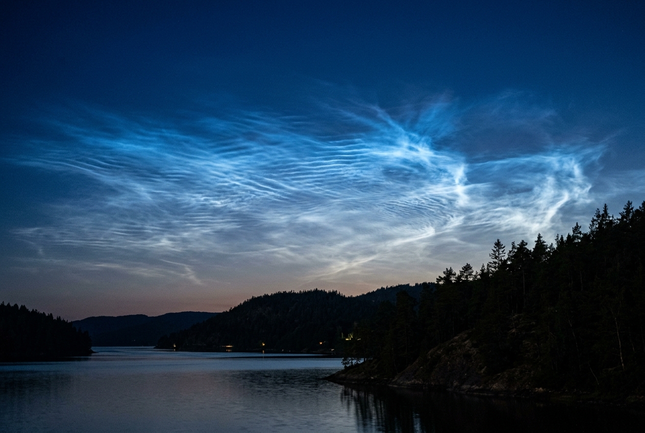
1. Opening Scene
Midnight on the summer solstice along the Moray Firth in northern Scotland is not true night, but a suspended, violet dusk. The air at ground level is heavy and still, fragrant with the brackish damp of sea-kelp, crushed gorse, and the cooling peat of the coastal bluffs. Your jacket is zipped against the steady drop in temperature; the daytime warmth has radiated into an open sky, leaving the maritime grasses wet with heavy dew. A digital pocket thermometer reads a benign 9°C, and the pocket aneroid barometer rests at a stable 1018 hPa.
Looking south, the landscape is extinguished in indigo gloom. But looking north toward the pole, where the sun has dipped just out of sight behind the curvature of the North Sea, the horizon refuses to die.
       Viewer Line-of-Sight Geometry & Earth's Shadow Cone
========================================================================
                                      [ Mesospheric Ice Sheet: 85 km ]
                                                    / \
                                                   /   \ (Electric Blue)
                                                  /     \
                                                 /   .---* <--- Grazing Solar Rays
                                                /   /
              Observer (In Shadow)             /   /
                     \                        /   /
                      o                      /   /
                     /|\                    /   /
                    / | \                  /   /  (Troposphere & Stratosphere
           ~~~~~~~~~~---~~~~~~~~~~~~~~~~~~'   /    in Complete Shadow)
             EARTH CURVATURE                 /
                                            /
                                           /  <--- Umbral Shadow Boundary
========================================================================
High above the marine inversion, above the flight paths of transatlantic airliners, above the weather itself, a spectral web of electric-blue filaments begins to condense against the stellar background. They do not drift like ordinary cirrus; they shine with an unnatural, incandescent pearlescence, like glowing gossamer or fractured porcelain lit from within. Rippling herringbone waves and intricate, razor-sharp billows march across the sky at incredible speed, silently revealing the turbulent respiration of our planet’s frontier with interplanetary space. These are noctilucent—night-shining—clouds, the highest, coldest, and rarest clouds on Earth.
2. What's Actually Happening — Plain English First
To understand why these luminous ribbons appear only during the short nights of high summer, think of the atmosphere as a layered cake where each storey obeys radically different thermodynamic and mechanical rules.
Atmospheric Layering & Noctilucent Cloud Genesis:
------------------------------------------------------------------------
 Altitude
  (km)
  100 +----------------------------------------------------------------+
      | THERMOSPHERE : Solar X-rays & extreme UV heating               |
   85 +================================================================+ <-- MESOPAUSE (130 K / -143°C)
      | MESOSPHERE   : Gravity wave upwelling & adiabatic supercooling |     [ Noctilucent Clouds Form Here ]
   50 +----------------------------------------------------------------+ <-- STRATOPAUSE (Warm: Ozone UV absorption)
      | STRATOSPHERE : Ozone layer absorbs UV; dry, stable air         |
   12 +----------------------------------------------------------------+ <-- TROPOPAUSE
      | TROPOSPHERE  : Weather, moisture, turbulence, convective storms|
    0 +----------------------------------------------------------------+ (Earth's Surface)
------------------------------------------------------------------------
The bottom layer—the troposphere—contains virtually all the water vapour, storms, and air we breathe. Above it lies the stratosphere, where ozone absorbs ultraviolet light and warms the air. Above that, between 50 and 85 kilometres up, sits the enigmatic mesosphere.
Under normal circumstances, clouds cannot exist in the mesosphere. The air is a hundred thousand times drier than the Sahara desert, and the atmospheric pressure is less than one-thousandth of that at sea level—a near-vacuum equivalent to the laboratory vacuum inside a cathode-ray tube.
Yet, during the summer months at latitudes between 50° and 65°, three extreme conditions align to create these glowing veils:
- The Cosmic Spotlight (Twilight Geometry): The clouds sit at an altitude of 80 to 85 kilometres. Long after the sun has set for an observer on the ground, casting the lower 50 kilometres of the atmosphere into deep shadow, solar rays still skim past the curvature of the Earth at high altitudes. The sun illuminates the mesosphere from underneath, while leaving the troposphere below in pitch darkness.
- The Great Thermodynamic Paradox: Intuition suggests that the polar atmosphere should be warmest during summer, when the sun never sets. In the mesosphere, the exact opposite occurs: the summer polar mesopause is the coldest natural environment on Earth, plunging below 130 Kelvin (−143°C). This deep freeze is not caused by a lack of sunlight, but by a global atmospheric air-conditioner: rising columns of air driven by breaking atmospheric waves expand violently and cool as they ascend.
- Meteoric Smoke and Ghostly Water: To make an ice cloud in a near-vacuum, water molecules need a scaffold to cling to. This scaffolding is provided by micrometeoroids—millions of tiny space rocks that vaporise upon hitting the upper atmosphere, condensing into a microscopic "smoke" of iron, magnesium, and silicate nanoparticles. Water vapour rising from tropospheric storms and generated by the photochemical breakdown of methane freezes directly onto this meteoric dust, building nano-crystals of pure ice.
3. The Science (for those who want to go deeper)
To quantify how these noctilucent clouds (NLCs)—known scientifically as Polar Mesospheric Clouds (PMCs) when observed from orbit—generate their distinctive electric-blue luminosity, we must unpack the geometric, thermodynamic, and optical mechanics of the upper atmosphere.
A. Twilight Observation Geometry: The Solar Depression Angle
Noctilucent clouds are visible from the ground only when the contrast ratio between the sunlit mesospheric ice layer and the background sky is maximised. This requires the observer and the lower atmosphere to sit within the Earth’s shadow cone (the umbra), while the cloud deck at altitude $H \approx 85\text{ km}$ remains bathed in unattenuated solar radiation.
The geometric relationship is governed by the Solar Depression Angle ($\alpha$), defined as the angular distance of the Sun’s centre below the ideal astronomical horizon.
       Solar Depression & Tangent Geometry
------------------------------------------------------------------------
                              Ray from Sun (skimming Earth's surface)
                             ----------------------------------------->
                                        |
                                        | Tangent Point
                                        v
                            . - ~ ~ - . + - - - - - - - - - -> [Cloud at H]
                        . '             ' .                   /
                      /                     \                /
                     /           Earth       \              /
                    |           Centre        |            / (R_E + H)
                    |              O----------+-----------+
                     \             |         / R_E
                      \            | \ alpha/
                        . _      R_E   \   /
                            . - _ _ _ _ . '
------------------------------------------------------------------------
Let $R_E \approx 6,371\text{ km}$ be the mean volumetric radius of the Earth, and let $h_{\text{screen}} \approx 10-15\text{ km}$ represent the "screening height"—the altitude of the dense, aerosol-laden tropospheric layer that effectively blocks grazing sunlight.
From the right-angled triangle formed by the Earth's centre, the tangent point of the solar ray at the screening altitude, and the illuminated cloud base:
$$\cos \alpha = \frac{R_E + h_{\text{screen}}}{R_E + H_0}$$
Rearranging this expression allows an observer to calculate the minimum shadow height ($H_0$) cast by the Earth for a given solar depression angle $\alpha$:
$$H_0 = (R_E + h_{\text{screen}})\sec \alpha - R_E$$
When $\alpha$ is small ($\alpha < 6^\circ$, civil twilight), the shadow height $H_0$ is low, leaving the troposphere and stratosphere illuminated; Rayleigh scatter from the dense lower atmosphere washes out the faint mesospheric emissions. When $\alpha > 16^\circ$ (astronomical night), the shadow height exceeds $90\text{ km}$, swallowing the mesopause in darkness.
Worked Example: The 10° Midsummer Optimum
Consider an observer at 56°N on 21 June at local solar midnight, where the solar depression angle reaches $\alpha = 10.0^\circ$. Let the effective tropospheric screening height be $h_{\text{screen}} = 12\text{ km}$.
- Calculate the effective tangent radius:
$R_{\text{eff}} = 6371\text{ km} + 12\text{ km} = 6383\text{ km}$.- Compute the secant of the solar depression angle:
$\sec(10.0^\circ) = \frac{1}{\cos(10.0^\circ)} = \frac{1}{0.984808} \approx 1.015427$.- Calculate the illuminated shadow boundary height:
$H_0 = (6383 \times 1.015427) - 6371 = 6481.47 - 6371 = 110.47\text{ km}$ along the tangent path, with grazing line-of-sight overhead shadow heights settling between: $$H_{\text{overhead}} \approx R_E (\sec \alpha - 1) = 6371 \times (1.015427 - 1) = 98.28\text{ km}$$Because the noctilucent cloud layer sits at $82-85\text{ km}$, an angle of $\alpha = 8^\circ-12^\circ$ creates a grazing projection geometry where the lower $60\text{ km}$ of the column is in midnight blackness, while the ice crystals at $85\text{ km}$ gleam in direct sunlight.
B. The Thermodynamic Paradox: Gravity-Wave Driven Mesospheric Upwelling
Radiative balance calculations indicate that the summer polar mesosphere, subjected to continuous 24-hour solar insolation, should reach equilibrium temperatures around $220\text{ K}$ (−53°C). Instead, measurements by satellite sounders and ground-based lidar routinely record temperatures between $110\text{ K}$ and $130\text{ K}$ (−163°C to −143°C)—the coldest point in the terrestrial planetary system.
This extreme departure from radiative equilibrium is maintained by the mesospheric residual circulation (a high-altitude branch of the Brewer-Dobson circulation), driven by the breaking of atmospheric gravity waves.
       The Mesospheric Residual Engine
========================================================================
 SUMMER POLE (85 km)                             WINTER POLE (85 km)
 [ T < 130 K : DEEP FREEZE ]                     [ T > 220 K : WARM ]
            ^                                             |
            | ADIABATIC                                   | ADIABATIC
            | EXPANSION                                   | COMPRESSION
            | (Upwelling: w ~ 1-3 cm/s)                   v (Downwelling)
            |                                             |
            +========= GLOBAL MERIDIONAL DRIFT ===========+
            |          (Wave-Drag Induced Pole-to-Pole)   |
            |                                             |
    ================= GRAVITY WAVE BREAKING ZONE =================
            ^                                             ^
           / \   Convection, Fronts, Mountain Waves      / \
          /   \  Propagating Upward from Troposphere    /   \
========================================================================
- Wave Propagation: Convective storms, frontal boundaries, and jet-stream shear in the troposphere generate internal gravity waves (buoyancy oscillations). As these waves propagate upward into rarefied air, their amplitude $A(z)$ must grow exponentially to conserve kinetic energy density: $$A(z) = A_0 \exp\left(\frac{z}{2H_s}\right)$$ where $H_s \approx 7\text{ km}$ is the atmospheric scale height.
- Wave Breaking & Momentum Deposition: In the mesosphere ($70-85\text{ km}$), wave amplitudes become unstable and break (analogous to ocean waves crashing on a beach). This deposition of momentum exerts a powerful westward force (wave drag) that breaks the geostrophic balance of the mesospheric polar vortex.
- Induced Upwelling: To balance this momentum deficit, the atmosphere sets up a global pole-to-pole circulation, driving air horizontally from the summer pole to the winter pole. Mass continuity forces intense vertical upwelling over the summer polar cap at velocities of $w \approx 1-3\text{ cm s}^{-1}$.
As air ascends in the mesosphere without external heat addition, it undergoes adiabatic expansion against declining ambient pressure. The resulting dynamical cooling rate is governed by the First Law of Thermodynamics:
$$\left(\frac{\partial T}{\partial t}\right)_{\text{dyn}} = -w \left( \Gamma_d - \Gamma \right) \approx -w \frac{g}{c_p}$$
where $g \approx 9.55\text{ m s}^{-2}$ at $85\text{ km}$, and $c_p \approx 1005\text{ J kg}^{-1}\text{ K}^{-1}$ is the specific heat of dry air at constant pressure.
$$\frac{g}{c_p} \approx 9.5\text{ K km}^{-1} \quad (\text{Dry Adiabatic Lapse Rate})$$
For an upwelling velocity of $w = 2.5\text{ cm s}^{-1}$ ($2.16\text{ km day}^{-1}$):
$$\left(\frac{\partial T}{\partial t}\right)_{\text{dyn}} \approx -2.16\text{ km day}^{-1} \times 9.5\text{ K km}^{-1} \approx -20.5\text{ K day}^{-1}$$
This violent dynamical refrigeration overwhelms solar radiative heating, depressing the local mesopause temperature by over $80\text{ K}$ and driving relative humidity with respect to ice to extreme supersaturation ($S > 100$).
C. Microphysics: Meteoric Smoke & Methane Oxidation
At an altitude of $85\text{ km}$, total atmospheric pressure drops to $P \approx 0.4\text{ Pa}$ ($4\times 10^{-6}\text{ bar}$). Water vapour mixing ratios are meager—typically only $3-5\text{ ppmv}$ (parts per million by volume).
The partial pressure of water vapour ($e_{\text{H}_2\text{O}}$) is:
$$e_{\text{H}2\text{O}} = \chi{\text{H}_2\text{O}} \times P \approx (4 \times 10^{-6}) \times 0.4\text{ Pa} = 1.6 \times 10^{-6}\text{ Pa}$$
According to the Clausius-Clapeyron relation, the saturation vapour pressure over ice ($e_{\text{sat}}$) drops precipitously with temperature:
$$\ln\left(\frac{e_{\text{sat}}}{e_0}\right) = \frac{L_{\text{sub}}}{R_v}\left(\frac{1}{T_0} - \frac{1}{T}\right)$$
Temperature vs Saturation Vapour Pressure at the Mesopause:
========================================================================
 Temperature (K)     e_sat over Ice (Pa)     Supersaturation (S = e/e_sat)
------------------------------------------------------------------------
 150 K (-123°C)      1.2 x 10^-3 Pa          S = 0.0013 (No Ice Formation)
 140 K (-133°C)      3.5 x 10^-5 Pa          S = 0.045  (Dry Sublimation)
 130 K (-143°C)      4.8 x 10^-7 Pa          S = 3.33   (Ice Growth Enabled)
 120 K (-153°C)      1.9 x 10^-9 Pa          S = 842.0  (Explosive Nucleation)
========================================================================
At $125\text{ K}$, the saturation pressure collapses to orders of magnitude below ambient vapour pressure. However, homogeneous nucleation (water molecules spontaneously coalescing into an ice lattice) cannot occur at these low collision frequencies. Nucleation must be heterogeneous.
                   Microphysical Nucleation Sequence
------------------------------------------------------------------------
   Ablating Meteoroids (~100 tonnes/day enter Earth's atmosphere)
                             |
                             v
   Meteoric Smoke Particles (MSPs: Fe-Mg Silicates, r ≈ 0.5 - 1.5 nm)
                             +
   Mesospheric Water Vapour (Tropospheric transport + CH4 Oxidation)
                             |
                             v  (Heterogeneous Nucleation at T < 130 K)
   Ice Embryos (r ≈ 3 nm)
                             |
                             v  (Vapour Deposition & Sedimentation)
   Matured NLC Ice Crystals (r ≈ 20 - 70 nm, Hexagonal / Amorphous Ice)
------------------------------------------------------------------------
The water vapour itself has two primary origins: 1. Direct Upwelling: Slow advection of tropospheric water through the tropical tropopause hygropause. 2. Methane Oxidation: Anthropogenic and natural methane ($\text{CH}_4$) transported into the stratosphere and mesosphere undergoes photolysis and reaction with excited oxygen atoms $\text{O}(^1\text{D})$ and hydroxyl radicals ($\text{OH}$), described globally by:
$$\text{CH}_4 + 2\text{O}_2 \xrightarrow{h\nu, \text{OH}} \text{CO}_2 + 2\text{H}_2\text{O}$$
Each oxidised methane molecule yields two water vapour molecules in the middle atmosphere. Rising global methane emissions over the industrial era have steadily increased mesospheric humidity, making noctilucent cloud displays noticeably more frequent and brighter over the past century.
D. Optical Scattering & The Chappuis Ozone Filter
Why do noctilucent clouds display their signature electric, sapphire-blue colour rather than the neutral silver-white of tropospheric cirrus?
The colour is the combined result of two physical mechanisms: diffraction scattering off nanometre-scale particles and selective absorption along the solar ray's path through the stratospheric ozone layer.
                   The Chappuis Ozone Absorption Filter
========================================================================
 Sun (Grazing Ray)
  =================> [ STRATOSPHERIC OZONE LAYER (20-30 km) ]
                     ----------------------------------------
                     Red/Orange Photons (550-650 nm): ABSORBED
                     Blue Photons (400-480 nm): TRANSMITTED
                     ----------------------------------------
                                         |
                                         v Filtered Blue Light
                                 [ NLC ICE SHEET (85 km) ]
                                 (Ice Crystals: r = 40 nm)
                                         |
                                         v Rayleigh / Anomalous Scatter
                                  (Observer Eyes / Camera)
========================================================================
-
Rayleigh–Mie Scattering Regime: Mesospheric ice crystals reach mean radii of $r \approx 30-50\text{ nm}$. Comparing this radius to visible wavelengths ($\lambda \approx 400-700\text{ nm}$), the dimensionless size parameter $x$ is: $$x = \frac{2\pi r}{\lambda} \approx \frac{2\pi (40\times 10^{-9}\text{ m})}{500 \times 10^{-9}\text{ m}} \approx 0.5$$ Because $x < 1$, scattering falls largely into the Rayleigh regime, where scattered intensity $I(\lambda)$ scales inversely with the fourth power of wavelength: $$I(\lambda) \propto \frac{1}{\lambda^4}$$ Shorter blue wavelengths ($\lambda = 420\text{ nm}$) are scattered roughly five times more efficiently than longer red wavelengths ($\lambda = 650\text{ nm}$).
-
The Chappuis Band Absorption: More critically, the low-elevation solar rays that illuminate the mesosphere must graze the Earth's limb, passing tangentially through the stratospheric ozone maximum ($20-30\text{ km}$). This creates an extreme optical path (air mass factor $m > 30$).
The Chappuis absorption band of ozone absorbs light between $500\text{ nm}$ and $700\text{ nm}$ (yellow, orange, and red wavelengths). As sunlight traverses thousands of kilometres of stratospheric ozone, its yellow-red spectrum is filtered out, leaving a pure, spectral cyan-blue beam to strike the ice crystals at $85\text{ km}$.
4. Practical Outdoor Guidance
Observing noctilucent clouds requires understanding the interaction between local seasonal geometry and atmospheric wave dynamics. Use the following structured protocol from the World Meteorological Organization (WMO) International Cloud Atlas to identify, classify, and photograph these mesospheric structures.
       Morphological Classification of Mesospheric Ice Structures
========================================================================
 TYPE I: VEILS                    TYPE II: BANDS & STRIPES
 Simple, structureless, diffuse   Long, parallel luminous streaks, often
 background sheets of faint blue. occurring in groups (Wave trains).
 -------------------------------- --------------------------------------
 TYPE III: BILLOWS                TYPE IV: WHIRLS & ROTORS
 Tightly spaced, wave-like crests Complex looping curtains, distorted
 (Kelvin-Helmholtz shears).       rings, and violent rotational eddies.
========================================================================
What to Look For in the Sky
- The Observation Window: In the Northern Hemisphere, watch between 20 May and 15 August, with peak activity occurring within two weeks of the summer solstice (21 June). In the Southern Hemisphere, monitor from 20 November to 15 February.
- Geographic Latitudes: Optimal visibility lies between 50° and 65° latitude (e.g., the UK, Scandinavia, Canada, Northern US states, New Zealand, and Patagonia). Above 65°, the midnight sky is too bright; below 50°, the solar depression angle drops too rapidly into deep shadow.
- Clock Timing: Monitor the northern horizon (or southern horizon in the Southern Hemisphere) between 11:00 PM and 2:30 AM local solar time, corresponding to solar depression angles of $6^\circ \le \alpha \le 16^\circ$.
Field Instrumentation & Diagnostics
- Surface Barometer: Monitor for rapid surface barometric fluctuations ($\pm 0.5\text{ hPa}$ within $30\text{ minutes}$); these microbarograph anomalies signal deep convective systems or jet-streak dynamics launching the internal gravity waves required for mesospheric cooling.
- Diagnostic Morphology:
- Type II Bands: Wide, parallel bands indicate large-scale planetary gravity waves ($50-100\text{ km}$ wavelength) propagating through the mesosphere.
- Type III Billows: Closely spaced combs (wavelengths $\sim 5-10\text{ km}$) reveal high-altitude Kelvin-Helmholtz shear instability, where intense wind shears tear the upper boundary of the mesospheric cloud sheet into breaking wave crests.
Camera Settings for Night-Sky Observers
Because mesospheric gravity waves move at phase speeds of $40-100\text{ m s}^{-1}$ ($144-360\text{ km/h}$), long exposures will blur their delicate filamentary structure. - Mount: Solid tripod with manual focus set precisely to infinity (use a bright star like Vega or Capella). - Focal Length: $24\text{ mm}$ to $50\text{ mm}$ for broad structural context; $85\text{ mm}$ to $135\text{ mm}$ for Kelvin-Helmholtz billow close-ups. - Exposure Time: Keep exposures between $1.0$ and $4.0\text{ seconds}$. Never exceed 6 seconds. - Aperture & ISO: Set aperture wide open ($f/1.8-f/2.8$) and ISO between $400$ and $1600$ to minimise thermal noise while retaining edge contrast.
5. Today's Meteorological Rule of Thumb
The Twilight Mesosphere Rule:
If the midnight sky two hours after sunset remains dark enough to see third-magnitude stars, yet your northern horizon reveals delicate, electric-blue ripples that cast fine shadows through a telephoto lens, you are not looking at weather in our atmosphere—you are observing sunlight scattered off meteoric smoke coated in ice, frozen at −140°C in the edge of space by an atmospheric refrigerator powered by gravity waves.
Further Reading & Meteorological Resources
- Track real-time upper-atmosphere satellite tracking and polar mesospheric cloud maps via NASA's AIM (Aeronomy of Ice in the Mesosphere) Mission Archive.
- Learn more about noctilucent cloud classification through the Met Office Cloud Guide.
- Consult the official morphological identification standards in the WMO International Cloud Atlas.
- Explore upper-atmosphere dynamics and planetary wave breaking at the Royal Meteorological Society.
- Study global mesospheric circulation datasets through the National Oceanic and Atmospheric Administration (NOAA).