Mesoscale Convective Vortex (MCV) Dynamics & Inertial Stability: How Latent Heating Cores and Mid-Level Cyclonic Spin Fuel Long-Lived Storm Rebirth
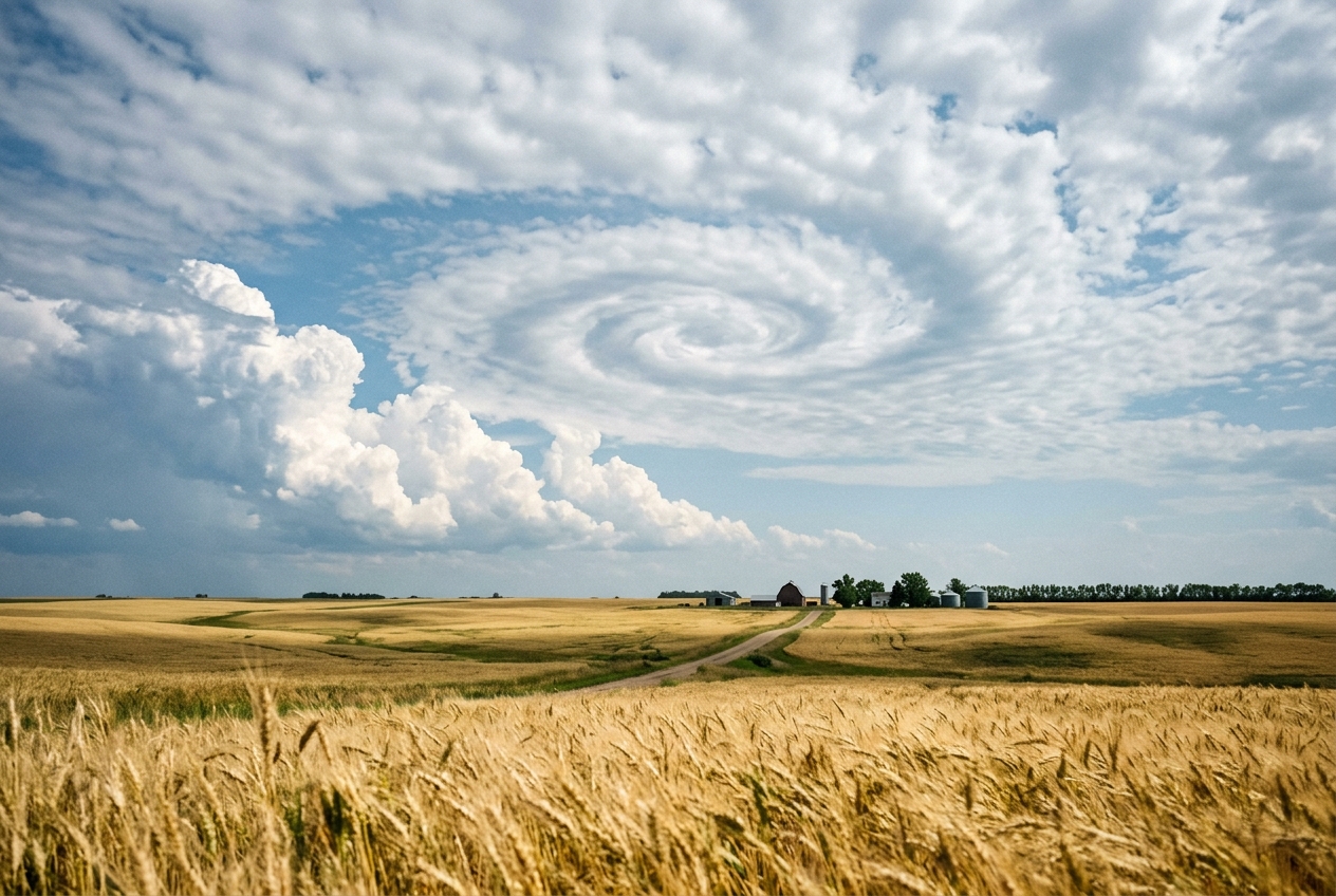
The night’s ferocious tempest has finally surrendered to the morning light, leaving behind a stillness that feels almost conspiratorial. By eight o'clock, the violent squall line that shook windowpanes and battered roofs with gale-force downbursts has rumbled away to the east. At ground level, the frantic turbulence has collapsed into a cool, sodden calm. Steam curls off black asphalt as the rising sun bites into the drenched earth, filling the air with the earthy tang of petrichor and rich, humid ozone. Puddles mirror a sky that appears, at first glance, to be clearing.
Yet if you step outside into an open field, tilt your head back, and fix your gaze on the mid-level cloud canopy between ten and fifteen thousand feet, the atmosphere tells a far more sinister story.
High above the tranquil surface, the ragged remnants of the thunderstorm complex—a bruised deck of altocumulus and shredded altostratus—are not drifting lazily with the prevailing westerly breeze. Instead, they are wheeling. Slowly, silently, and with the deliberate grace of a cosmic carousel, the entire cloud deck is rotating counter-clockwise. There is no thunder, no rain, and barely a whisper of wind against your cheek. The barometric pressure on your home weather station has plateaued, yet the air feels dense, charged, and unsettled. By midday, as the midsummer sun burns through the thinned cloud sheet, intense solar radiation begins to cook the moisture-laden surface air.
Then, around two in the afternoon, the deceptively peaceful carousel detonates. Without any approaching cold front or regional storm system in sight, explosive white towers of cumulonimbus erupt along the southern flank of that spinning cloud deck. Within forty minutes, the tranquil morning yields to a new generation of violent, hail-bearing supercells.
You have just witnessed the lifecycle of one of the atmosphere’s most fascinating and dangerous phenomena: a Mesoscale Convective Vortex (MCV).
                       VERTICAL ANATOMY OF AN MCV

   Upper Troposphere   [ - - - Anticyclonic Outflow Shield - - - ]    (~11 km)
                              \                       /
   ----------------------------\---------------------/----------------
                                \   NEGATIVE PV     /
                                 \  (dθ̇/dz < 0)    /
   Mid-Troposphere                =================                   (~5.5 km)
   (Freezing Level)              [ PEAK LATENT HEAT ]
                                  =================
                                 /  POSITIVE PV    \
                                /   (dθ̇/dz > 0)     \
   Lower Troposphere           /  Cyclonic Spin Core \                (~2.5 km)
   ---------------------------/-----------------------\---------------
   Surface Boundary Layer    [ Warm Moist Air ] ---> [ Inflow Ingestion ] (Surface)
What Is Actually Happening: Plain English First
To understand how a dying storm system gives birth to an invisible atmospheric ghost that can trigger violent storms hours later, think of the atmosphere not as a uniform block of air, but as a vast, multi-layered sponge cake. Each tier of this cake possesses a distinct temperature, density, and moisture profile.
During the night, a sprawling cluster of thunderstorms known as a Mesoscale Convective System (MCS) consumes immense volumes of warm, humid air. As this water vapor rises into the freezing middle and upper levels of the troposphere (roughly three to six miles above our heads), it condenses into water droplets and freezes into ice crystals. This change of state releases colossal quantities of latent heat—the hidden energy stored within water vapor. In a mature storm cluster, the energy released can rival the electrical output of an industrialized nation over several hours.
This localized, massive heating acts like an enormous thermal engine embedded right in the middle layer of the atmospheric cake:
- Mid-Level Heat Concentration: The heaviest condensation and freezing occur roughly midway up the troposphere, around 500 millibars of atmospheric pressure (about 5.5 kilometres altitude). This level becomes an intense island of warmth.
- The Squeeze and the Spin: Air beneath this heating peak is pulled upward toward the thermal maximum. As air columns beneath the heat source are stretched vertically, they must contract horizontally to conserve their mass.
- The Ice Skater Effect: Just as a spinning ice skater rotates faster when pulling their arms inward toward their chest, this horizontal contraction forces the air column to spin more rapidly. Because our planet rotates, the background spin of the Earth (the Coriolis effect) is concentrated into a tight, localized cyclonic whirlpool spanning 50 to 250 kilometres in diameter.
- The Protective Shield: Once this mid-level whirlpool spins up, it develops what meteorologists call inertial stability. Think of a rapidly spinning bicycle wheel: it resists being tilted or knocked off balance. Similarly, the spinning core of the MCV creates a dynamic "force field" that insulates its warm, moist interior from the disruptive crosswinds and dry environmental air that would otherwise shred it.
When the parent thunderstorm system runs out of nocturnal fuel and dies around dawn, the rain stops and the cold surface winds decay. But the spinning mid-level vortex—the MCV—remains perfectly preserved aloft, drifting silently across the continent like a spinning top.
As morning turns to afternoon, solar heating warms the ground below. The spinning vortex aloft tilts the surrounding temperature surfaces, forcing the warm, humid surface air to glide upward like a train ascending a mountain track. The moment this rising air breaches the capping inversion, violent thunderstorms erupt anew.
The Science: Potential Vorticity and Inertial Insulation
To decipher the persistence and reproductive power of an MCV, atmospheric dynamicists rely on two foundational concepts: Ertel’s Potential Vorticity and Inertial Stability.
1. The Genesis Mechanism: Ertel’s Potential Vorticity (PV)
Potential Vorticity (PV) is the ultimate tracer in fluid dynamics. It combines the absolute rotation of an air parcel with its static stability (how resistant it is to vertical displacement). Under adiabatic (no heat exchanged) and frictionless conditions, PV is strictly conserved along fluid trajectories, as catalogued by the World Meteorological Organization.
However, within the stratiform rain region of a dying storm complex, latent heating is decidedly non-adiabatic (diabatic). The generation of potential vorticity by diabatic heating is governed by the Ertel Potential Vorticity tendency equation:
$$\frac{D(PV)}{Dt} \approx \frac{1}{\rho} \left( \boldsymbol{\zeta} + 2\boldsymbol{\Omega} \right) \cdot \nabla \dot{\theta}$$
Where: * $\rho$ is the atmospheric air density ($\text{kg}\cdot\text{m}^{-3}$). * $\boldsymbol{\zeta} = \nabla \times \mathbf{u}$ is the relative vorticity vector of the air parcel ($\text{s}^{-1}$). * $2\boldsymbol{\Omega}$ is the planetary vorticity vector ($f = 2\Omega \sin\phi$ is the vertical Coriolis parameter). * $\dot{\theta} = \frac{d\theta}{dt}$ is the diabatic heating rate, expressed as the material change in potential temperature over time ($\text{K}\cdot\text{s}^{-1}$).
Under typical mid-latitude mesoscale approximations, vertical gradients dominate horizontal gradients, allowing us to simplify the equation for the vertical component of Potential Vorticity ($q$):
$$\frac{D q}{Dt} \approx \frac{1}{\rho} (\zeta_z + f) \frac{\partial \dot{\theta}}{\partial z}$$
What the Equation Predicts in Plain English: Potential vorticity (cyclonic spin and stability) is generated in layers where the heating rate increases with height ($\frac{\partial \dot{\theta}}{\partial z} > 0$). Conversely, potential vorticity is destroyed where the heating rate decreases with height ($\frac{\partial \dot{\theta}}{\partial z} < 0$).
                         THE PV GENERATION DIPOLE

   Altitude (z)                                            dθ̇/dz
        ^
   10 km|           /\  Anticyclonic Anomaly (Negative PV)    < 0
        |          /  \ (Upper Tropospheric Outflow)
    6 km|---------/----\---------------------------------    = 0 [Peak Latent Heat]
        |        /      \ Cyclonic Vortex Core (Positive PV)
    2 km|_______/        \ (Mid-Tropospheric MCV)             > 0
        +--------------------------------------------------> Heating Rate (θ̇)
In the stratiform region of a convective system, the maximum latent heating from condensation and freezing occurs at the mid-tropospheric melting layer (around $z \approx 5.5\text{ km}$, or $500\text{ hPa}$).
- Below the heating peak ($z < 5.5\text{ km}$): The heating rate increases rapidly with height ($\frac{\partial \dot{\theta}}{\partial z} > 0$). This acts as a relentless PV factory, spinning up a potent cyclonic vortex ($+PV$ anomaly) between $700\text{ hPa}$ and $500\text{ hPa}$.
- Above the heating peak ($z > 5.5\text{ km}$): The heating rate tapers off toward the tropopause ($\frac{\partial \dot{\theta}}{\partial z} < 0$). This destroys PV, generating an anticyclonic ($ -PV$) outflow shield at $300\text{ to }200\text{ hPa}$.
A Worked Numerical Example: The Birth of a Vortex
Let us calculate the rate of cyclonic PV generation in the lower-to-mid troposphere ($z = 2.5\text{ km}$ to $5.5\text{ km}$) beneath the stratiform anvil of a nocturnal storm complex over the American Midwest or the European continent (latitude $\phi = 43^\circ\text{N}$).
-
Coriolis Parameter ($f$): $$f = 2 \times (7.292 \times 10^{-5}\text{ s}^{-1}) \times \sin(43^\circ) \approx 0.994 \times 10^{-4}\text{ s}^{-1}$$
-
Ambient Relative Vorticity ($\zeta_z$): Assume pre-existing weak cyclonic shear within the storm environment: $\zeta_z = 0.5 \times 10^{-4}\text{ s}^{-1}$. The absolute vorticity is: $$\eta = \zeta_z + f = (0.5 \times 10^{-4}) + (0.994 \times 10^{-4}) = 1.494 \times 10^{-4}\text{ s}^{-1}$$
-
Diabatic Heating Profile ($\dot{\theta}$): Suppose intense condensation releases heat such that $\dot{\theta}$ reaches a peak of $36\text{ K per day}$ at $z = 5.5\text{ km}$, starting from near zero at cloud base ($z = 2.5\text{ km}$). Converting $36\text{ K/day}$ into SI units: $$\dot{\theta}_{\text{peak}} = \frac{36\text{ K}}{86,400\text{ s}} \approx 4.167 \times 10^{-4}\text{ K}\cdot\text{s}^{-1}$$ The vertical gradient of heating over the $\Delta z = 3,000\text{ m}$ depth is: $$\frac{\partial \dot{\theta}}{\partial z} = \frac{4.167 \times 10^{-4}\text{ K}\cdot\text{s}^{-1}}{3,000\text{ m}} \approx 1.389 \times 10^{-7}\text{ K}\cdot\text{m}^{-1}\cdot\text{s}^{-1}$$
-
Air Density ($\rho$): At $700\text{ hPa}$ (approx. $3\text{ km}$ altitude), standard atmospheric density is $\rho \approx 0.90\text{ kg}\cdot\text{m}^{-3}$.
-
Calculating the PV Generation Rate: $$\frac{D q}{Dt} \approx \frac{1}{0.90} \times (1.494 \times 10^{-4}\text{ s}^{-1}) \times (1.389 \times 10^{-7}\text{ K}\cdot\text{m}^{-1}\cdot\text{s}^{-1})$$ $$\frac{D q}{Dt} \approx 1.11 \times 10^{-1} \times 2.075 \times 10^{-11} \approx 2.30 \times 10^{-11}\text{ m}^2\cdot\text{s}^{-1}\cdot\text{K}\cdot\text{kg}^{-1}\cdot\text{s}^{-1}$$
In meteorology, one Potential Vorticity Unit (PVU) is defined as $1.0 \times 10^{-6}\text{ m}^2\cdot\text{s}^{-1}\cdot\text{K}\cdot\text{kg}^{-1}$. Converting our result: $$\frac{D q}{Dt} = 2.30 \times 10^{-5}\text{ PVU}\cdot\text{s}^{-1} \approx 0.0828\text{ PVU per hour}$$
Over an 8-hour overnight lifespan of a long-lived convective complex, this vertical heating gradient generates: $$\Delta q = 0.0828\text{ PVU/hr} \times 8\text{ hr} \approx 0.66\text{ PVU}$$
When added to the baseline background tropospheric value of $\sim 0.3\text{–}0.5\text{ PVU}$, the local potential vorticity more than doubles, creating an anomalous, self-sustaining vortex core exceeding $1.0\text{ to }1.2\text{ PVU}$. This is a massive dynamic footprint left behind in the mid-troposphere, documented extensively in research published by the American Meteorological Society.
2. The Dynamic Fortress: Inertial Stability ($I^2$)
Why does this spinning anomaly not shear apart under the influence of ambient upper-level winds? The secret lies in Inertial Stability ($I^2$), which represents the resistance of a swirling vortex to radial (inward or outward) displacements.
For an axisymmetric vortex in gradient-wind balance, the inertial stability parameter in cylindrical coordinates ($r, \lambda, z$) is defined as:
$$I^2 = \left( \zeta_{\text{rel}} + f \right) \left( \frac{2v}{r} + f \right) = \left( \frac{\partial v}{\partial r} + \frac{v}{r} + f \right) \left( \frac{2v}{r} + f \right)$$
Where: * $v$ is the tangential wind speed ($\text{m}\cdot\text{s}^{-1}$) at radius $r$ ($\text{m}$). * $\zeta_{\text{rel}} = \frac{\partial v}{\partial r} + \frac{v}{r}$ is the relative vorticity of the vortex. * $\frac{2v}{r}$ represents twice the angular velocity of the flow (the curvature term). * $f$ is the planetary Coriolis parameter.
What the Equation Predicts in Plain English: The stronger the spin ($\zeta_{\text{rel}}$) and the tighter the curvature ($\frac{v}{r}$), the larger the inertial stability $I^2$ becomes. A high $I^2$ acts like a stiff physical barrier, preventing surrounding dry air from penetrating the core and forcing any energy released inside to stay trapped within the vortex.
                         INERTIAL STABILITY SHIELD

          Environmental Shear Winds            Environmental Shear Winds
                 =========>                           =========>
                          \                         /
      .....................\......................./...................
      :                     v                     v                   :
      :               +-------------------------------+               :
      :               |     HIGH INERTIAL STABILITY   |               :
      :  Intrusion    |          (I² >> f²)           |   Intrusion   :
      :  Deflected    |   [ Warm, Saturated Core ]    |   Deflected   :
      :   <========   |                               |   ========>   :
      :               |    Trapped Convective Energy  |               :
      :               +-------------------------------+               :
      :...............................................................:
Crucially, the Rossby radius of deformation ($L_R$), which defines the fundamental horizontal scale over which balanced adjustments occur, shrinks when inertial stability increases:
$$L_R = \frac{N H}{\sqrt{I^2}}$$
Where $N$ is the Brunt–Väisälä buoyancy frequency (a measure of static stability) and $H$ is the vertical scale height. When $I^2 \gg f^2$, $L_R$ collapses from its typical synoptic scale ($\sim 1,000\text{ km}$) down to mesoscale dimensions ($\sim 50\text{–}150\text{ km}$).
Because the deformation radius shrinks, the atmosphere can no longer disperse the latent heat outward as fast-moving gravity waves. Instead, the heating is forced to remain in the vortex core, dynamically equilibrating into rotational kinetic wind energy.
A Worked Numerical Example: The Force Field of the Core
Consider an MCV observed by the NOAA Storm Prediction Center drifting over the central United States: * Core radius: $r = 50\text{ km} = 5.0 \times 10^4\text{ m}$ * Peak tangential mid-level wind speed: $v = 15\text{ m}\cdot\text{s}^{-1}$ * Assuming solid-body rotation near the inner core: $\frac{\partial v}{\partial r} \approx \frac{v}{r} = \frac{15}{50,000} = 3.0 \times 10^{-4}\text{ s}^{-1}$ * Relative vorticity: $\zeta_{\text{rel}} = \frac{\partial v}{\partial r} + \frac{v}{r} = 6.0 \times 10^{-4}\text{ s}^{-1}$ * Coriolis parameter: $f = 1.0 \times 10^{-4}\text{ s}^{-1}$
Let us calculate the ambient background inertial stability ($I_{\text{ambient}}^2$) versus the vortex core inertial stability ($I_{\text{core}}^2$):
-
Ambient Background Stability (where $v = 0$ and $\zeta = 0$): $$I_{\text{ambient}}^2 = f^2 = (1.0 \times 10^{-4}\text{ s}^{-1})^2 = 1.0 \times 10^{-8}\text{ s}^{-2}$$
-
Vortex Core Stability: First term (Absolute Vorticity): $$\zeta_{\text{rel}} + f = (6.0 \times 10^{-4}) + (1.0 \times 10^{-4}) = 7.0 \times 10^{-4}\text{ s}^{-1}$$
Second term (Modified Coriolis/Curvature): $$\frac{2v}{r} + f = 2(3.0 \times 10^{-4}) + (1.0 \times 10^{-4}) = 7.0 \times 10^{-4}\text{ s}^{-1}$$
Multiplying the two terms together: $$I_{\text{core}}^2 = (7.0 \times 10^{-4}\text{ s}^{-1}) \times (7.0 \times 10^{-4}\text{ s}^{-1}) = 49.0 \times 10^{-8}\text{ s}^{-2}$$
- Comparison: $$\frac{I_{\text{core}}^2}{I_{\text{ambient}}^2} = \frac{49.0 \times 10^{-8}}{1.0 \times 10^{-8}} = 49$$
The Physical Consequence: The vortex core exhibits an inertial resistance to lateral displacement 49 times greater than the surrounding environment. It acts as an impenetrable atmospheric fortress, preserving its deep moisture reservoir and warm thermal core as it migrates across hundreds of miles of continental terrain.
                       AFTERNOON REIGNITION GEOMETRY

               South / Equatorward                     North / Poleward

   Mid-Levels         [ MCV CYCLONIC CORE ]
   (500 hPa)               \
                            \   Isentropes (θ) Tilt Downward
                             \  Toward Cold Low-Level Pool
                              \
   Lower Levels        Ascent  \
   (700 hPa)          ======>   \  Isentropic Upglide
                     /           \
   -----------------/-------------\----------------------------------
   Surface        [ Insolation ]   [ Cold Stable Surface Pool ]
                  [ Uncapped ]
                  [ CAPE > 2500]
                        |
                        V
               * EXPLOSIVE NEW *
               *  SUPERCELLS   *
How Balanced Vortices Re-Ignite Violent Convection
The key to an MCV’s destructive afternoon resurgence lies in the contrast between balanced vortex dynamics and unbalanced boundary layer processes, a subject of ongoing study at institutions such as the UK Met Office.
1. Isentropic Tilting and Differential Advection
A mature MCV is in approximate hydrostatic and gradient wind balance. By the thermal wind relation, a warm-core cyclonic vortex in the mid-troposphere mandates that the surfaces of constant potential temperature (isentropes, $\theta$) must bow downward beneath the vortex core and bow upward above it.
As ambient environmental mid-level flow encounters this balanced anomaly, the air is forced to travel along these tilted isentropic surfaces. On the equatorward and downshear flank of the vortex, this produces a persistent, broad zone of isentropic upglide (quasi-geostrophic ascent).
2. The Solar Trigger and Differential Heating
While the morning mid-level cloud deck drifts overhead, the spatial distribution of sunshine creates a hazardous thermodynamic juxtaposition: * The Stratiform Shadow: Directly under the denser cloud debris, solar heating is suppressed, maintaining a relatively cool, stable planetary boundary layer. * The Cleared Flank: Along the southern and western periphery of the vortex, the skies clear rapidly. Intense solar insolation drives boundary-layer temperatures into the upper 30s Celsius ($>90^\circ\text{F}$), while surface evapotranspiration pumps dewpoints past $22^\circ\text{C}$ ($72^\circ\text{F}$).
This creates a sharp differential heating boundary—effectively a localized warm front. When this boundary aligns with the vortex’s mid-level isentropic ascent and the low-level wind shear generated by the MCV's circulation, the convective inhibition (CIN) is completely eroded. Convective Available Potential Energy (CAPE) often exceeds $3,000\text{ J}\cdot\text{kg}^{-1}$. The resulting thunderstorm updrafts ingest the pre-existing vertical vorticity of the MCV, causing them to rapidly rotate and evolve into tornadic supercells.
Radar and Satellite Tracking: Spotting the Ghost
Forecasters tracking these "ghost vortices" rely on distinct observational signatures:
| Instrument / Channel | Key Diagnostic Signature | Physical Mechanism |
|---|---|---|
| Visible Satellite | Distinct comma-shaped "pinwheel" of mid-level altocumulus clouds with a clear eye-like center. | Solid-body rotation advecting cloud elements around the closed circulation center. |
| Water Vapor (6.2–6.9 µm) | Swirling dry slot wrapping tightly into a moist, cyclonic vortex core. | Dynamic tropopause depression and mid-tropospheric dry air entrainment along the vortex periphery. |
| Doppler Radar (Base Velocity) | Symmetric inbound/outbound velocity couplet aloft ($3\text{–}6\text{ km}$) with near-zero wind at the surface. | Mid-level closed circulation decoupled from the surface friction layer. |
| Dual-Polarization Radar | Concentric rings of uniform correlation coefficient ($\rho_{HV}$) and differential reflectivity ($Z_{DR}$). | Light, uniform remnant stratiform drizzle and pristine ice crystals caught in circulation. |
Practical Outdoor Guidance: Reading the Ghost Sky
You do not need access to a supercomputer or a Doppler radar array to anticipate an MCV-induced storm outbreak. A thoughtful observer in the field can detect the subtle precursors of an approaching or overhead vortex.
1. What to Look for in the Sky
- The Morning Pinwheel: After a nocturnal storm complex passes, look up between 08:00 and 11:00 AM. Watch for bands of shredded altocumulus or altostratus that move in directions contradictory to the surface breeze. If you see clouds in the north moving west while clouds in the south move east, you are standing directly beneath an MCV.
- Asymmetric Sunshine: If the sky clears rapidly to your south while remaining locked in a persistent, ragged cloud deck to your north, you are in the prime dynamic ignition zone.
- Agitated Cumulus Congestus: By 12:30–13:30 PM, look toward the sunny edge of the cloud swirl. If puffy cumulus clouds suddenly transition from flat-topped pancakes into explosive, hard-edged towers with boiling vertical velocity, convective initiation has begun.
                           THE OBSERVER'S SKY MAP

                              [ NORTH / WEST ]
                          Dense Mid-Level Shield
                         (Altostratus / Altocumulus)
                                     ^
                                    / \
                                   /   \  Counter-Clockwise
                                  /  ↺  \    Cloud Motion
                                 /       \
         -----------------------/---------\------------------------
                                \         /
                                 \       /
                                  \     /   CLEARING ZONE:
                                   \   v    Intense Sun / Baking Turf
                              [ SOUTH / EAST ]
                                     |
                                     V
                            [ WATCH FOR RAPID ]
                            [ CUMULUS TOWERING]
2. Instrument Readings on a Home Weather Station
- Digital Barometer: Watch for a subtle "meso-low" pressure signature. The pressure will not plunge dramatically as it does during a winter cyclone; instead, it will display a shallow, gentle dip of 1.5 to 3.0 hectopascals (hPa) that persists even as the morning temperature rises.
- Surface Wind Vane: You will often observe decoupled winds. At ground level, the wind may be light and southeasterly (feeding rich moisture into the region), while observing low-to-mid level cloud motion reveals strong southerly or southwesterly shear.
- Hygrometer / Thermometer: Beware of rapid surface recovery. If the thermometer climbs swiftly above $30^\circ\text{C}$ while the dewpoint remains stubbornly above $20^\circ\text{C}$ following morning rain, the thermodynamic charge is primed for explosive release.
3. Rules of Thumb for Outdoor Decision Making
- For Hikers and Campers: If a morning thunderstorm clears out, do not assume the atmosphere has spent its fury for the day. If the residual cloud deck exhibits cyclonic curvature and the sun emerges hot and humid, seek low ground and shelter before 14:00.
- For Sailors and Boaters: An MCV passing over a warm lake or coastal sea can rapidly spin down to the surface, transforming from an elevated circulation into a sudden 40-knot gale or waterspout cluster with less than thirty minutes of visual warning.
- For Gardeners and Farmers: Morning storms that leave a spinning cloud deck are classic producers of large, destructive afternoon hail. The high freezing levels combined with severe rotating updrafts provide ideal conditions for hailstone recirculation and growth.
Today's Meteorological Rule of Thumb
The Rule of the Morning Carousel:
When a nocturnal tempest dies at dawn but leaves the morning clouds spinning like a carousel beneath the rising sun, the storm is not dead—it is merely reloading. Expect violent, rotating afternoon storms along the sunny edge of that mid-level swirl.
Further Reading & Authoritative Meteorological Resources
- American Meteorological Society Glossary: Mesoscale Convective Vortex
- NOAA Storm Prediction Center: Mesoscale Convective Systems & Vortex Dynamics
- Met Office Research: Atmospheric Dynamics & Potential Vorticity
- World Meteorological Organization: Global Weather Research Programme
- Wikipedia: Potential Vorticity Dynamics & Ertel's Theorem