Mammatus Cloud Dynamics & Negative Buoyancy: How Hydrometeor Loading and Sub-Cloud Evaporation Sculpt Pendulous Anvil Pouches
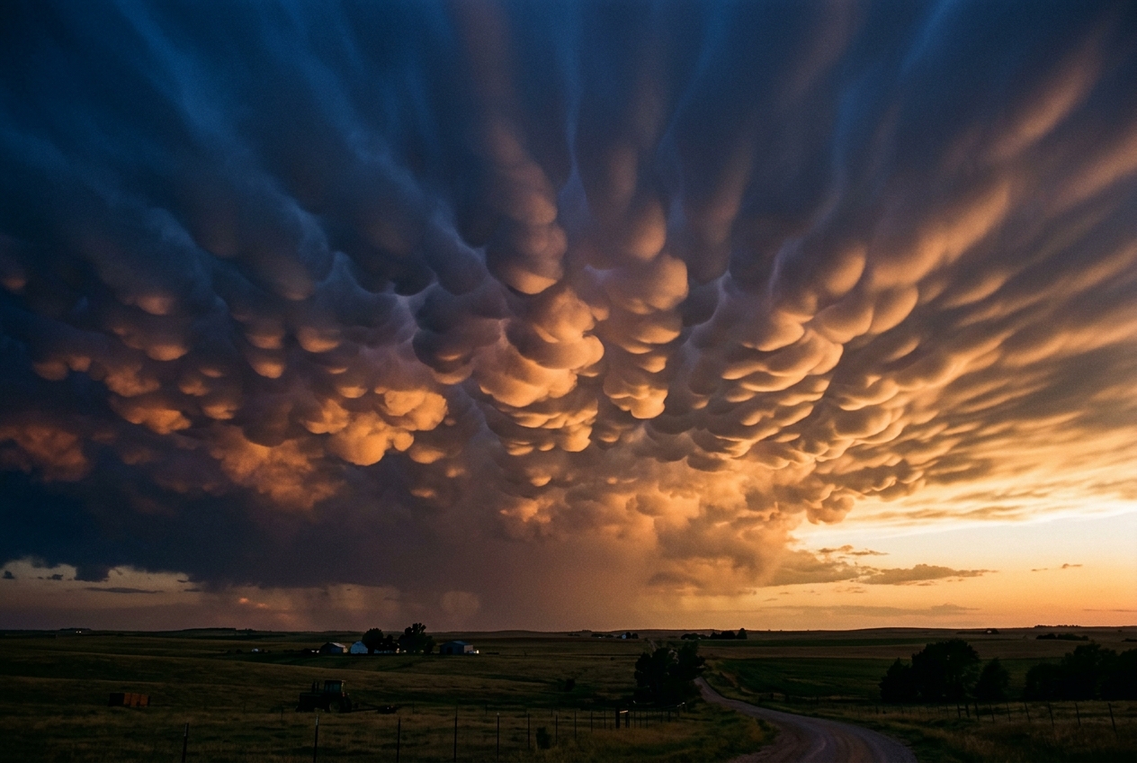
Instead of flat, frayed cloud bases or boiling cauliflower towers ascending into the stratosphere, the underside of the canopy droops toward the earth in hundreds of smooth, bulbous pouches. They hang like heavy udders or overturned domes of polished marble, suspended in the half-light, glowing in shades of ochre, bronze, and charcoal. Beneath them, there is no rain, no sudden tempest, only an eerie, suspended stillness and the rich smell of petrichor carried on cool air from distant downpours. To the human eye, these structures appear unstable—as if the sky were an ocean of suspended lead on the verge of collapsing.
These are mammatus clouds (formally designated as the supplementary cloud feature mamma by the World Meteorological Organization). For centuries, their appearance has triggered awe and unease among sky observers, often provoking folklore that they represent the imminent descent of tornadoes. Yet to the atmospheric dynamicist, mammatus clouds represent one of the most elegant thermodynamic balancing acts in the natural world: a localized inversion of ordinary convection, where the sky does not boil upward, but sinks downward in organized, self-limiting lobes.
What Is Actually Happening: Convection in Reverse
To understand why mammatus clouds are so unusual, one must first recognize the fundamental rule of ordinary clouds: clouds are born in updrafts.
Think of the lower atmosphere as a towering layer cake. Near the ground, the air is baked by solar radiation, becoming lighter and less dense than the layers above it. Like a submerged hot-air balloon or a cork released under water, this buoyant bubble of warm, moist air accelerates upward. As it climbs into zones of lower atmospheric pressure, it expands and cools. When it reaches its dew point, water vapor condenses into liquid droplets and ice crystals, releasing latent heat that acts like an internal furnace, propelling the cloud even higher into towering cumulus turrets.
Mammatus clouds invert this entire thermodynamic script. They do not form in rising plumes of warm air; they are formed by pockets of cold, dense air sinking into dry, unsaturated space beneath a thunderstorm's glaciated anvil.
Imagine taking a dense, waterlogged sponge and placing it over an open heating vent. If the sponge contains a mixture of heavy water droplets, fine ice crystals, and slushy graupel, two distinct phenomena occur simultaneously:
- Hydrometeor Weight: The physical mass of millions of tons of suspended ice crystals exerts a downward gravitational pull on the parcel of air holding them.
- Evaporative and Sublimative Refrigeration: As the base of the cloud begins to sag into the dry, warm air beneath the anvil, the ice crystals immediately begin to sublime directly from solid ice into invisible water vapor, and liquid droplets evaporate.
Phase changes require enormous amounts of thermal energy. When ice sublimes or water evaporates, it extracts heat from the surrounding air parcel, chilling it rapidly. This chilled air becomes significantly denser than the dry ambient air immediately surrounding and underlying it.
Consequently, the cloud parcel begins to plunge toward the earth under the influence of negative buoyancy. It is an upside-down convection cell—a localized downdraft sculpted into smooth, pendulous bulbs rather than jagged, chaotic curtains.
The Science of Negative Buoyancy and Downward Momentum
To transition from conceptual intuition to quantitative atmospheric dynamics, we must inspect the governing force of buoyant acceleration in non-hydrostatic atmospheres. In fluid dynamics, the vertical acceleration of an air parcel is dictated by the balance between the vertical pressure gradient force, turbulent frictional drag, and buoyancy.
1. The Governing Buoyancy Equation with Hydrometeor Loading
In the absence of severe vertical perturbation pressure gradients, the vertical buoyant acceleration $B$ acting on an air parcel within the sub-anvil environment is expressed through the perturbation of virtual potential temperature ($\theta_v$) coupled with the downward mass-loading drag of condensate:
$$B = g \left[ \frac{\theta_v'}{\theta_{v0}} - q_l - q_i \right]$$
Where: * $g$ is the gravitational acceleration ($9.81 \text{ m/s}^2$). * $\theta_v'$ is the perturbation of virtual potential temperature ($\theta_v - \bar{\theta}v$), representing the thermal and vapor density difference between the descending cloud parcel and the ambient sub-cloud environment (measured in Kelvin, $\text{K}$). * $\theta{v0}$ is the base-state virtual potential temperature of the ambient background environment ($\text{K}$). * $q_l$ is the liquid water mixing ratio ($\text{kg of liquid water per kg of dry air}$). * $q_i$ is the ice mixing ratio ($\text{kg of ice crystals/graupel per kg of dry air}$).
This equation, documented widely in research through the American Meteorological Society and the NOAA National Severe Storms Laboratory, exposes the dual engines driving the negative buoyancy ($B < 0$):
- Thermal and Moisture Perturbation ($\theta_v' / \theta_{v0}$): Sublimation of ice and evaporation of water extract latent heat of sublimation ($L_s \approx 2.83 \times 10^6 \text{ J/kg}$), cooling the parcel and driving $\theta_v'$ sharply negative.
- Dead-Weight Condensate Drag ($- q_l - q_i$): The actual physical mass of suspended hydrometeors (ice crystals, snow aggregates, graupel) directly adds weight to the parcel, operating as an effective negative buoyancy term even before sublimation occurs.
Worked Example: Calculating Parcel Negative Buoyancy
Consider an observation beneath a severe storm's anvil at an altitude of $7,500\text{ m}$ (where ambient pressure $p \approx 400\text{ hPa}$):
- Base-state ambient virtual potential temperature: $\theta_{v0} = 310.0\text{ K}$
- Sublimation-induced cooling creates a thermal deficit: $\theta_v' = -1.8\text{ K}$
- Ice hydrometeor mixing ratio within the dense anvil pocket: $q_i = 0.0025\text{ kg/kg}$ ($2.5\text{ g/kg}$)
- Liquid water content is negligible at this altitude: $q_l = 0\text{ kg/kg}$
We substitute these values into the negative buoyancy formulation:
$$B = 9.81 \times \left[ \frac{-1.8}{310.0} - 0 - 0.0025 \right]$$
$$B = 9.81 \times \left[ -0.005806 - 0.0025 \right]$$
$$B = 9.81 \times [ -0.008306 ] = -0.0815\text{ m/s}^2$$
A downward acceleration of $-0.0815\text{ m/s}^2$ may appear modest compared to freefall under gravity, but across an atmospheric parcel measuring hundreds of meters in diameter, it generates powerful localized downdrafts capable of forming distinct morphological lobes in minutes.
2. Sinking Velocity and the Deceleration Mechanism
Unlike convective storm downdrafts that slam into the earth as destructive microbursts, mammatus lobes descent at controlled, steady speeds of approximately $1\text{ to }3\text{ m/s}$, eventually halting smoothly in mid-air. Why don't they continue accelerating to the ground?
The descent rate is bounded by two opposing mechanisms: aerodynamic form drag/turbulent mixing and the loss of hydrometeor mass via complete sublimation. As the downward-plunging lobe descends into warmer, drier sub-cloud air, the descent velocity $w$ reaches a quasi-steady terminal downdraft velocity governed by the kinetic energy integral:
$$w(z) = \sqrt{w_0^2 + 2 \int_{z_0}^{z} \left( B(z') - \frac{C_d}{2 R_{\text{lobe}}} w(z')^2 \right) dz'}$$
Where: * $w_0$ is the initial vertical velocity at the anvil base (typically $\sim 0\text{ m/s}$). * $C_d$ is the aerodynamic drag coefficient of the turbulent hemispherical lobe ($\sim 0.4\text{ to }0.6$). * $R_{\text{lobe}}$ is the characteristic radius of the mammatus pouch (typically $500\text{ to }1,500\text{ m}$). * $z_0 - z$ is the descent depth.
Worked Example: Steady-State Lobe Velocity
Suppose a mammatus lobe with radius $R_{\text{lobe}} = 750\text{ m}$ descends across a vertical distance $\Delta z = 300\text{ m}$ under an average net effective buoyancy $\bar{B} = -0.045\text{ m/s}^2$ (accounting for progressive ice loss), starting from rest ($w_0 = 0$).
Assuming terminal velocity equilibrium where acceleration balances turbulent form drag ($\frac{dw}{dt} \approx 0$):
$$|B| \approx \frac{C_d}{2 R_{\text{lobe}}} w_{\text{term}}^2$$
Solving for $w_{\text{term}}$:
$$w_{\text{term}} = \sqrt{\frac{2 R_{\text{lobe}} |B|}{C_d}}$$
Substituting $R_{\text{lobe}} = 750\text{ m}$, $|B| = 0.045\text{ m/s}^2$, and $C_d = 0.5$:
$$w_{\text{term}} = \sqrt{\frac{2 \times 750 \times 0.045}{0.5}} = \sqrt{\frac{67.5}{0.5}} = \sqrt{135} \approx 2.12\text{ m/s}$$
The lobe sinks at a controlled rate of $2.12\text{ m/s}$.
As it descends, the remaining ice crystals vanish into the dry sub-anvil air through phase change. Once $q_i \to 0$, evaporative cooling ceases entirely. The parcel now encounters the warmer, statically stable ambient air of the sub-cloud inversion layer. The thermal perturbation switches from negative to positive relative to the lower environment, arresting the downward descent and creating the classic rounded, smooth base of the lobe before it can rupture into falling precipitation.
+-------------------------------------------------------------------------+
|                  HYDRODYNAMIC INSTABILITY COMPARISON                    |
+-------------------------------------------------------------------------+
| Feature               | Cumulus Turret         | Mammatus Lobe          |
+-----------------------+------------------------+------------------------+
| Driving Mechanism     | Positive Buoyancy (+B) | Negative Buoyancy (-B) |
| Dominant Phase Change | Condensation (Heating) | Sublimation (Cooling)  |
| Vertical Motion       | Updraft (5–40 m/s)     | Downdraft (1–3 m/s)    |
| Interfacial Dynamics  | Rayleigh-Taylor Plume  | Inverted R-T / Kelvin- |
|                       | with shear mixing      | Helmholtz boundary     |
| Structural Lifetime   | 10–30 minutes          | 15–60 minutes          |
| Final Fate            | Glaciation / Anvil out | Evaporative extinction |
+-------------------------------------------------------------------------+
Rayleigh-Taylor Instability vs. Evaporative Sedimentation
In classical hydrodynamics, when a dense fluid rests directly on top of a less dense fluid in a gravitational field, the interface is inherently unstable—a phenomenon known as the Rayleigh-Taylor (R-T) Instability.
For decades, early cloud physicists hypothesized that mammatus clouds were simply pure atmospheric manifestations of Rayleigh-Taylor instability, analogous to heavy oil placed above water. However, atmospheric numerical models (such as those pioneered by Schultz et al. and validated by Met Office Cloud Studies) demonstrate that Rayleigh-Taylor dynamics alone cannot sustain mammatus lobes.
Pure R-T instability in dry fluids causes rapid turbulent entrainment: the descending fingers quickly shred themselves, mixing with the underlying fluid and diluting their density within seconds. Mammatus lobes, by contrast, maintain distinct, smooth structural integrity for up to an hour.
This coherence is maintained by phase-change memory: as dry air is entrained along the margins of the descending lobe, it triggers fresh sublimation of ice crystals at the boundary. This continuous refrigeration maintains the density contrast along the lobe's perimeter, re-sharpening the boundary even as interfacial turbulent shear (Kelvin-Helmholtz instability) attempts to tear it apart.
Debunking the Tornado Myth
One of the most persistent pieces of weather folklore across North America, Europe, and Australia is the belief that mammatus clouds are a direct harbinger of tornadoes. Observers seeing the bruised, chaotic underbelly of the sky often assume that the pendulous pouches are "tornadoes trying to form upside down."
This folklore is meteorologically incorrect.
Tornadogenesis requires: * Extreme, concentrated upward convective acceleration fueled by intense positive CAPE (Convective Available Potential Energy). * Low-level horizontal vorticity tilted vertically by a powerful rotating updraft (mesocyclone), as detailed by Wikipedia's meteorological analysis. * Strong surface convergence beneath a lowering wall cloud.
Mammatus clouds, conversely, occur in regions of broad, gentle, stable subsidence. They are most commonly found beneath the expansive, high-altitude anvil cloud miles away from the active updraft core—frequently on the trailing or flanking edges of a decaying mesoscale convective system (MCS) or supercell.
While mammatus clouds confirm that the parent thunderstorm was severe enough to pump massive quantities of ice and hydrometeors into the upper troposphere, the lobes themselves indicate that you are standing beneath an area of localized descent and anvil dissipation, not an impending funnel cloud.
Practical Outdoor Guidance: The Observer's Field Protocol
For field meteorologists, storm spotters, hikers, and sky photographers, observing mammatus clouds offers a masterclass in atmospheric thermodynamics. Here is how to diagnose and read the anvil stability regime when mammatus clouds appear overhead.
1. What to Look for in the Sky
- Lobe Morphology: Inspect the sharpness of the lobe margins. Smooth, distinctly rounded pouches indicate high ice concentrations and active sublimative cooling. When the edges become fibrous and ragged (virga-like), the ice supply has exhausted itself, and the lobes will dissipate within 10–15 minutes.
- Sun Angle and Scattering Physics: The most dramatic mammatus displays occur during the "golden hour" right before sunset. Because mammatus lobes are composed predominantly of densely packed ice crystals, low-angle sunlight strikes the curved lower surfaces, causing intense forward Mie scattering. The long optical path through the lower atmosphere filters out blue and green wavelengths, leaving only deep oranges, golds, and crimsons illuminating the pouches from beneath.
- Spatial Relationship to the Storm Core: Look toward the horizon. If the dense rain curtain and lightning-filled core are moving away from you while the anvil spreads overhead, you are in the safe, dissipating wake of the storm.
2. Instrumental Signatures to Watch
- Barometric Pressure: Watch your microbarograph or digital altimeter. During the passage of a mature anvil with mammatus, the pressure will generally level off or rise slightly into a "wake meso-high" or steady state, rather than showing the violent, plunging pressure drops characteristic of approaching mesocyclonic centers.
- Thermometer and Hygrometer (Dew Point Depression): You will observe a moderate, steady temperature drop combined with a widening dew-point depression (the gap between ambient temperature and dew point). The air beneath the anvil is unsaturated (relative humidity often $40\%\text{ to }60\%$), which is the critical prerequisite driving the sublimation of falling anvil ice.
- Anemometer (Wind Speed and Direction): Surface winds beneath mammatus are typically cool, gentle, and divergent—blowing outward from the distant storm core rather than accelerating into a tight convergent vortex.
3. Critical Safety Advisory for Aviators and Hikers
While mammatus clouds pose zero threat of producing tornadoes at the ground, they represent a serious hazard to aviation. The alternating 1–3 m/s downdrafts within the lobes and compensating inter-lobe updrafts create severe clear-air and in-cloud turbulence. General aviation pilots are advised by the Federal Aviation Administration and international flight safety standards to avoid flying through or directly beneath mature mammatus-bearing anvils.
Meteorological Rule of Thumb
"Upward boils build the storm; downward pouches mark its crown."
When the sky bulges downward in smooth, glowing lobes, you are witnessing the gentle, ice-chilled descent of a storm’s anvil—not the birth of a tornado, but the thermodynamic sunset of the convective engine.
Authoritative Meteorological References
- World Meteorological Organization (WMO) International Cloud Atlas: Supplementary Features - Mamma
- American Meteorological Society (AMS) Glossary of Meteorology: Mammatus Dynamics
- Met Office (UK): Cloud Identification and Mammatus Physics
- NOAA National Severe Storms Laboratory (NSSL): Severe Storm Structure and Anvils
- Wikipedia: Mammatus Cloud Thermodynamic Dynamics & History