Collision-Coalescence Process & Warm-Cloud Microphysics: How Droplet Size Spectra and Hydrodynamic Collection Unleash Maritime Downpours
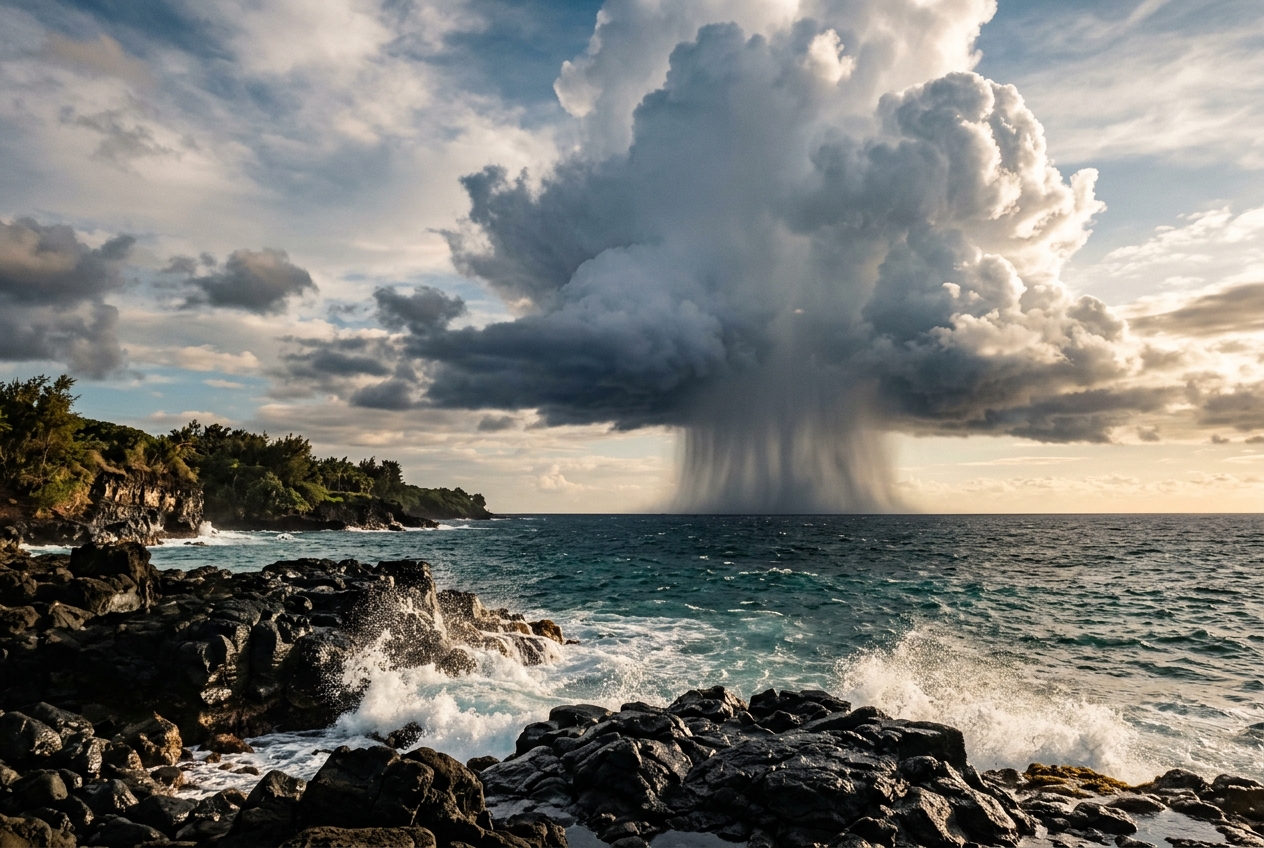
Stand on a sun-drenched headland along the Atlantic seaboard or a tropical coast in midsummer, and the atmosphere can feel heavy with moisture, yet entirely benign. The ocean breathes a steady, warm onshore breeze across the tide pools; the air carries the mineral tang of ozone and drying kelp. Above the coastal bluffs, brilliant white cumulus towers blossom against the blue, their bulbous crowns swelling upward at several metres per second. There is no lightning, no foreboding anvil of fibrous cirrus, and the freezing level sits comfortably thousands of metres above the cloud summits. The ambient temperature hovers at an unyielding 24°C.
Yet within fifteen minutes, the sky beneath one of these low-topped clouds darkens from pearlescent grey to deep slate. The wind drops for a breathless moment, and then the heavens open.
What falls is not the gentle, misting drizzle of a mid-latitude stratus deck, but a sudden, drenching barrage of heavy, warm raindrops—some spanning three or four millimetres in diameter. They strike the dry soil with an audible hiss, releasing the rich, earthy scent of geosmin before turning the coastal tracks into rushing rivulets. To the uninitiated observer, this sudden cloudburst defies classical elementary-school meteorology. There are no ice crystals here, no frozen high-altitude snowflakes melting on their journey downward. Instead, you have just witnessed one of the most elegant and fiercely debated mechanisms in atmospheric physics: the pure warm-rain collision-coalescence process.
1. What’s Actually Happening: The Microscopic Traffic Jam
For decades, mid-century meteorology rested on the foundational work of Tor Bergeron and Walter Findeisen, who proved that ice crystals grow rapidly at the expense of supercooled water droplets—the famous Bergeron-Findeisen process. But when meteorological reconnaissance flights in the 1940s and 1950s encountered torrential precipitation falling from Caribbean clouds whose summits were entirely warmer than 0°C, atmospheric scientists were confronted with the "Warm Rain Paradox." How could microscopic droplets, each smaller than the thickness of a fine silk thread, aggregate into a billion-fold larger raindrop in less than half an hour without the assist of ice?
To understand why this is extraordinary, consider the life of a newborn cloud droplet.
When moist air rises, it expands and cools adiabatically until its relative humidity slightly exceeds 100%. Water vapour must condense onto microscopic airborne particles known as Cloud Condensation Nuclei (CCN)—specks of sea salt, sulfate aerosols, or organic dust.
Initially, this process of direct vapour diffusion is remarkably swift. Millions of droplets form simultaneously, competing for the available excess water vapour. But as these droplets grow from a fraction of a micrometre up to roughly 15 or 20 micrometres ($\mu\text{m}$) in radius, an intrinsic physical roadblock emerges: the condensation bottleneck.
Think of a growing droplet like a team of painters whitewashing a giant sphere. When the sphere is tiny (like a marble), a single brushstroke covers a massive percentage of its surface, and the sphere’s radius visibly balloons almost instantly. But as the sphere grows to the size of a beach ball, its surface area expands with the square of the radius ($4\pi r^2$), while the total volume of paint required expands with the cube ($4/3\pi r^3$). Even if water vapour molecules deposit onto the droplet at a steady rate, the outward advancement of the droplet’s radius slows to an agonizing crawl.
Mathematically, the radial growth rate from diffusion alone is inversely proportional to the radius itself:
$$\frac{dr}{dt} \propto \frac{1}{r}$$
If condensation were the only engine available to a cloud, growing a single typical raindrop with a radius of 1 millimetre ($1,000\,\mu\text{m}$) from vapour would require between 12 and 24 hours of continuous, undisturbed supersaturation. Yet most convective cumulus clouds exist for only 30 to 45 minutes before dissipating.
To bridge this chasm from a $20\,\mu\text{m}$ cloud droplet to a $1,000\,\mu\text{m}$ raindrop, the cloud must abandon chemical diffusion and switch to mechanical combat: hydrodynamic collision and coalescence.
2. The Science: Hydrodynamics, Aerodynamic Sweeping, and the Collection Kernel
The transition from diffusion to collision requires an initial disparity in size. If every droplet inside a cloud were precisely $15\,\mu\text{m}$ in radius, they would all fall at exactly the same terminal velocity through the air. Like cars travelling at the exact same speed down a multi-lane motorway, they would never collide.
Nature breaks this symmetry through the chemistry and geography of aerosols. Over oceanic environments, wave-breaking action injects Giant Cloud Condensation Nuclei (GCCN)—coarse sea-salt particles larger than $1\,\mu\text{m}$—into the boundary layer. When condensation begins, these hyper-hygroscopic salt crystals deliquesce instantly, bypassing the early bottleneck and forming "lucky" collector droplets with radii of $25\text{ to }30\,\mu\text{m}$.
Because an object's gravitational force scales with its mass ($M \propto R^3$) while its aerodynamic drag scales with its cross-sectional area and speed, larger droplets attain significantly higher terminal fall speeds.
In the low-Reynolds-number regime governed by Stokes' Law, terminal velocity $v_t$ scales with the square of the radius:
$$v_t \approx k_s r^2 \quad (\text{for } r < 40\,\mu\text{m})$$
A $10\,\mu\text{m}$ droplet drifts downward relative to still air at barely $1\,\text{cm/s}$, while a $40\,\mu\text{m}$ collector drop plummets at roughly $20\text{ to }30\,\text{cm/s}$. The collector drop now acts as a gravitational vacuum cleaner, descending through a field of smaller, slower-falling droplets.
The Continuous Collection Equation
To calculate how rapidly this collector drop devours its neighbours, atmospheric dynamicists model its descent through a geometric cylinder of air. As the collector drop of radius $R$ and velocity $V(R)$ overtakes a population of smaller droplets of radius $r$ and velocity $v(r)$, the cross-sectional area swept out per unit time is determined by the combined radii $\pi(R + r)^2$ and the differential terminal velocity $[V(R) - v(r)]$.
However, not every droplet directly in the geometric path is captured. As the large drop falls, it pushes a bow wave of air ahead of it, setting up a curved aerodynamic flow field around its flanks. Tiny droplets with negligible mass possess too little inertia; they are swept around the collector drop along the air streamlines, avoiding impact altogether. Conversely, larger droplets possess sufficient momentum to pierce the streamlines and strike the collector.
This hydrodynamic interaction is parameterized by the Collision Efficiency ($E_{\text{coll}}$), defined as the ratio of the actual collision cross-section to the geometric cross-section. Once impact occurs, surface tension forces, air-film drainage, and electrical charges govern whether the two water bodies fuse into one or bounce apart, captured by the Coalescence Efficiency ($E_{\text{coal}}$). The product of these two factors gives the total Collection Efficiency:
$$E(R, r) = E_{\text{coll}}(R, r) \times E_{\text{coal}}(R, r)$$
For collector drops with $R \ge 40\,\mu\text{m}$ capturing droplets with $r \approx 10\text{--}15\,\mu\text{m}$, coalescence is nearly universal ($E_{\text{coal}} \approx 1.0$), making aerodynamic collision efficiency the primary limiting factor.
We can now express the Continuous Accretion Rate governing the mass growth of a single collector drop:
$$\frac{dM}{dt} = \pi (R + r)^2 [V(R) - v(r)] E(R, r) \rho_{\text{LWC}}$$
Where: * $M$ is the mass of the collector drop ($\text{kg}$), * $R$ and $r$ are the radii of the collector drop and cloud droplets ($\text{m}$), * $V(R)$ and $v(r)$ are their respective terminal fall speeds ($\text{m/s}$), * $E(R, r)$ is the collection efficiency (dimensionless, typically $0.6\text{ to }0.9$), * $\rho_{\text{LWC}}$ is the cloud's Liquid Water Content ($\text{kg/m}^3$ or $\text{g/m}^3$), quantified regularly by research instruments managed by organizations such as the UK Met Office and NOAA.
Step-by-Step Calculation: Accretion in Action
Let us put realistic numbers into this equation to see why collection growth is explosive.
Imagine a moderately vigorous maritime cumulus congestus cloud with a liquid water content $\rho_{\text{LWC}} = 1.5\,\text{g/m}^3 = 1.5 \times 10^{-3}\,\text{kg/m}^3$, populated mostly by background droplets of radius $r = 10\,\mu\text{m}$ ($v(r) \approx 0.012\,\text{m/s}$).
A lucky collector drop has just reached a radius of $R = 50\,\mu\text{m}$ ($5.0 \times 10^{-5}\,\text{m}$). At this size, its terminal velocity is $V(R) \approx 0.27\,\text{m/s}$, and its collection efficiency for $10\,\mu\text{m}$ droplets is approximately $E(R, r) \approx 0.70$.
Let us calculate its instantaneous rate of mass increase:
-
Calculate the effective geometric cross-section: $$(R + r) = (50 \times 10^{-6}) + (10 \times 10^{-6}) = 60 \times 10^{-6}\,\text{m}$$ $$\text{Area} = \pi (R + r)^2 = \pi \times (6.0 \times 10^{-5})^2 \approx 1.131 \times 10^{-8}\,\text{m}^2$$
-
Calculate the differential velocity: $$\Delta V = V(R) - v(r) = 0.27 - 0.012 = 0.258\,\text{m/s}$$
-
Compute the swept mass accretion rate ($dM/dt$): $$\frac{dM}{dt} = (1.131 \times 10^{-8}\,\text{m}^2) \times (0.258\,\text{m/s}) \times 0.70 \times (1.5 \times 10^{-3}\,\text{kg/m}^3)$$ $$\frac{dM}{dt} \approx 3.06 \times 10^{-12}\,\text{kg/s} = 3.06 \times 10^{-9}\,\text{g/s}$$
To appreciate what this means, let us compare this rate to the drop's current mass: * Current mass $M = \frac{4}{3} \pi R^3 \rho_w = \frac{4}{3} \pi (5.0 \times 10^{-5})^3 (1000\,\text{kg/m}^3) \approx 5.24 \times 10^{-10}\,\text{kg} = 5.24 \times 10^{-7}\,\text{g}$.
Dividing mass by growth rate: $$\tau_{\text{doubling}} \approx \frac{M}{dM/dt} = \frac{5.24 \times 10^{-7}\,\text{g}}{3.06 \times 10^{-9}\,\text{g/s}} \approx 171\,\text{seconds}$$
In under three minutes, the drop doubles in mass.
Because both terminal velocity $V(R)$ and cross-sectional area $\pi R^2$ scale up dramatically as the drop grows larger, this growth rate accelerates exponentially. By the time the drop reaches $R = 200\,\mu\text{m}$, its terminal velocity has surged to $1.6\,\text{m/s}$ and its collection efficiency approaches unity ($E \approx 1.0$).
The drop enters a runaway accretion cascade, sweeping through thousands of droplets every second, swelling into a full-sized $1.5\,\text{mm}$ raindrop in less than fifteen minutes as it falls through the cloud column.
3. Maritime vs Continental Regimes: Why Pollution Stifles Warm Rain
The efficiency of this warm rain cascade explains one of the most striking contrasts in global climatology: why clean ocean air produces torrential warm downpours with ease, while polluted continental air often produces non-raining haze or delayed, severe thunderstorms.
This divergence is governed by aerosol population dynamics, documented in cloud physics research synthesised by the World Meteorological Organization (WMO) and the American Meteorological Society (AMS).
| Microphysical Metric | Pristine Maritime Regime | Polluted Continental Regime |
|---|---|---|
| CCN Concentration | Low ($\approx 50\text{ to }100\,\text{cm}^{-3}$) | High ($\approx 1,000\text{ to }3,000\,\text{cm}^{-3}$) |
| Droplet Number Density ($N$) | Sparse ($\approx 50\text{ to }100\text{ droplets/cm}^3$) | Hyper-crowded ($\approx 1,000\text{ to }2,500\text{ droplets/cm}^3$) |
| Mean Droplet Radius ($\bar{r}$) | Broad spectrum; $\bar{r} > 15\text{--}20\,\mu\text{m}$ | Narrow spectrum; $\bar{r} < 6\text{--}8\,\mu\text{m}$ |
| Giant CCN Presence | Abundant (coarse sea salt, $\text{NaCl}$) | Deficient or masked by fine sulfates/organics |
| Collision Efficiency ($E$) | High ($E > 0.70$) | Near-zero ($E < 0.05$; aerodynamic deflection) |
| Warm Rain Initiation Time | Extremely rapid ($15\text{ to }30\text{ minutes}$) | Suppressed or impossible (requires glaciation) |
In maritime air, low CCN concentrations mean that the condensed water is shared among relatively few droplets, producing a broad size distribution with a large average radius. A handful of droplets quickly cross the critical $20\,\mu\text{m}$ threshold where collision efficiency leaps from near zero to significant values, setting off precipitation in shallow clouds barely 1,500 metres thick.
In polluted continental air, vast numbers of combustion particles and industrial aerosols divide the identical amount of water vapour among thousands of microscopic droplets. Because none of these droplets can overcome the condensation bottleneck to reach $20\,\mu\text{m}$, the entire population stays locked at $5\text{ to }8\,\mu\text{m}$. Their aerodynamic collision efficiencies remain essentially zero.
The cloud remains sterile of warm rain. It can only produce precipitation if its vigorous thermal updrafts push the cloud top above the freezing level (typically $-10^\circ\text{C}$ to $-20^\circ\text{C}$), where ice nucleation can finally bypass the stalemate—often resulting in late-afternoon hail, severe lightning, and downbursts rather than benign warm rain showers.
4. Practical Outdoor Guidance: Reading the Warm-Cloud Sky
You do not need an airborne cloud-physics laboratory to identify warm-rain mechanics in action. With basic field observations and atmospheric principles, any hiker, sailor, or outdoor enthusiast can spot warm rain clouds and gauge their rain potential.
1. Visual Diagnosis: The "Hard" vs "Soft" Cloud Top
To determine if a rain shower is pure warm-rain or ice-driven, observe the physical structure of the cloud's summit: * The Warm-Rain Cumulus Congestus: The top of the cloud retains crisp, hard, cauliflower-like contours with razor-sharp margins. This sharp edge is proof of liquid water droplets undergoing turbulent mixing with dry environmental air. If heavy precipitation shafts (virga) drop from the base while the cloud summit remains perfectly sharp and unglaciated, you are witnessing pure collision-coalescence. * The Glaciated Cumulonimbus: When cloud tops freeze, the liquid droplets transform into millions of ice crystals. The crisp, billowing cauliflower edges suddenly dissolve into a fuzzy, fibrous, silky veil—the formation of cirrus anvils. Once a cloud glaciates, ice microphysics (the Bergeron process) takes command.
2. The 1.5-Kilometre Depth Rule of Thumb
For warm rain to fall, a cloud must provide a sufficiently deep vertical column for collector drops to fall through and accumulate mass before they are swept out by updrafts or evaporated below cloud base. * Measure the Lifting Condensation Level (LCL)—the cloud base—which can be approximated using the surface temperature ($T$) and dew point ($T_d$) spread: $$\text{Cloud Base Height (m)} \approx 125 \times (T - T_d)$$ * The Field Rule: If the cloud base is at $800\,\text{m}$ and the freezing level (0°C isotherm) sits at $3,500\,\text{m}$, the cloud has up to $2,700\,\text{m}$ of warm liquid depth. If a maritime cumulus grows more than $1,500\,\text{metres}$ thick vertically within this warm zone, collision-coalescence will almost certainly trigger surface rain within 20 to 30 minutes, even if the cloud summit never freezes.
3. Reading Surface Instruments
- Barometer: A gentle, steady barometric plateau or mild falling tendency without the violent, jagged pressure spikes characteristic of thunderstorm cold pools.
- Thermometer: Unlike thunderstorm downdrafts, which plunge air temperatures by 8°C to 12°C via evaporating ice and melting hail, warm-rain showers produce very mild downdrafts. The rain falling on your skin feels neutral or warm, matching the ambient maritime air.
- Wind Direction: Watch for onshore surface flow. If steady ocean winds have spent hundreds of miles blowing across open water, you are immersed in a pristine maritime aerosol regime—primed for giant sea-salt CCN and rapid collision-coalescence showers.
5. Today's Meteorological Rule of Thumb
The next time you find yourself caught in a sudden, drenching shower under a low summer sky, look up at the edges of the cloud overhead. You are not feeling the melted remnants of distant mountain snow or high-altitude ice, but the culmination of a microscopic sweep: billions of water droplets, brought together by aerodynamic drag, surface tension, and gravity, defying the condensation bottleneck to fall as warm rain.