Bowen Ratio & Surface Energy Balance: How Sensible and Latent Heat Fluxes Dictate Boundary Layer Depth and Convective Initiation
1. Opening Scene: The Divided Valley
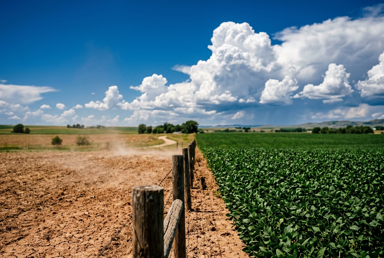
Stand in midsummer at the borderline where an arid, sun-bleached expanse of cracked loam abuts a wide, pivot-irrigated field of emerald alfalfa. Step out of your vehicle at two o’clock in the afternoon. The atmosphere above these two adjacent soils, bathed in the exact same solar irradiance from an unblemished blue sky, belongs to two entirely different physical realms.
Over the fallow, baked earth, the air is an aggressive, tactile presence. Waves of optical turbulence—the classic desert mirage—distort the distant foothills into shimmering liquid ribbons. The wind arrives in dry, stinging gusts, smelling of scorched dust and brittle straw. Look up, and a red-tailed hawk circles tightly without flapping a wing, riding a violent, invisible column of rising heat that climbs thousands of metres into the clear blue vault. The air feels hollow, thin, and desiccating. Your skin dries instantly; sweat evaporates before it can form a bead.
Step thirty paces south across the fence line into the lush canopy of the irrigated crop. Instantly, the environmental sensation shifts with jarring severity. The radiant furnace at your feet shuts off. The air feels dense, velvety, and cool against your face, carrying the sweet, vegetative scent of crushed chlorophyll and damp peat. The thermal updrafts disappear; the breeze settles into a soft, steady rustle.
Yet, looking past the immediate relief of the green canopy, your gaze is drawn to the northern horizon. While the dry terrain generates nothing but shimmering heat waves under an empty sky, a line of crisp, flat-bottomed cumulus clouds is beginning to swell directly over the boundary between the wet and dry lands. Within two hours, those innocuous cotton puffs will organize into a towering, anvil-topped cumulonimbus, darkening the afternoon sun and charging the valley with the ozone-sharp scent of approaching rain.
What invisible partition of energy dictates that one patch of earth boils the lower atmosphere into dry, soaring thermals, while another silently charges the sky with the latent fuel for a violent thunderstorm?
========================= MIDDAY SURFACE ENERGY PARTITIONING =========================

SOLAR DOWNWELLING RADIATION (Shortwave) + SKY EMISSION (Longwave)
                                       ↓
                           NET RADIATION (Rn)
                                       ↓
         +-----------------------------+-----------------------------+
         |                                                           |
  [ ARID TERRAIN: B > 5.0 ]                           [ IRRIGATED VEGETATION: B < 0.2 ]
  Rn - G partitioned mostly into:                     Rn - G partitioned mostly into:

      SENSIBLE HEAT FLUX (H)                               LATENT HEAT FLUX (λE)
      (Direct Air Warming)                                (Water Vapor Evapotranspiration)
         ↓                                                           ↓
  Deep, Turbulent Boundary Layer (zi ~ 3 km)          Shallow, Moisture-Rich Layer (zi ~ 800 m)
  Violent Dry Thermals / High Cloud Base              Low Condensation Level / Storm Fuel
======================================================================================
2. What’s Actually Happening — Plain English First
To understand why adjacent landscapes can craft completely different microclimates, we must examine the planet's surface not as passive dirt, but as an active thermodynamic heat exchanger.
Every square metre of land receives a torrential downpour of electromagnetic energy from the sun. When that solar radiation strikes the surface, the earth cannot hoard it; by the fundamental laws of energy conservation, every single watt must be accounted for. A small portion of this heat conducts downward into the ground, warming the deeper soil. The vast majority of the remaining energy, however, is thrown back upward into the atmosphere through two competing pathways.
Think of the ground as an electric hotplate on which you have placed two different cooking vessels: a dry cast-iron skillet and a deep pot of water.
If you crank the heat beneath a dry cast-iron skillet, all the thermal energy goes directly into raising the temperature of the metal. In turn, the skillet immediately heats the air touching it. The air expands, becomes lighter than its surroundings, and violently bubbles upward. This direct, measurable heating of the air is what meteorologists call Sensible Heat Flux ($H$). It is "sensible" because you can literally sense it with a standard thermometer or on your skin as hot air.
Now, consider the pot filled with water. As the hotplate pours energy into the pot, the water does not simply get hotter and hotter without limit. Instead, a tremendous amount of energy is consumed in breaking the intermolecular hydrogen bonds of liquid water, transforming it into invisible water vapour. The temperature of the boiling water stays fixed, but huge amounts of energy are locked away inside the escaping vapour molecules. This hidden heat is called Latent Heat Flux ($\lambda E$). The word latent comes from the Latin for "hidden": the energy has entered the atmosphere, but not as a rise in air temperature. It is stored as the thermodynamic potential of water vapour.
The atmosphere itself can be visualized as a giant, layered fluid reservoir sitting directly on top of this hotplate. The lowest layer—the Planetary Boundary Layer—is directly stirred and modified by surface heating.
When the ground is dry, the surface acts like the dry skillet. It pumps almost all available energy into Sensible Heat ($H$). This unleashes vigorous, chimney-like thermal plumes that relentlessly push upward, carving out an exceptionally deep, bone-dry boundary layer that can reach 3,000 to 4,000 metres into the sky.
Conversely, when the ground is wet and cloaked in vegetation, the surface acts like the pot of water. The plants open their microscopic stomata and, through the combined engine of evaporation and transpiration (evapotranspiration), divert the sun’s energy into pumping mass quantities of moisture into the air. The air near the ground stays remarkably cool, keeping the boundary layer shallow—often less than 1,000 metres deep. But that shallow layer becomes a compressed, hyper-concentrated reservoir of water vapour, waiting for a trigger to release its hidden power.
3. The Science (For Those Who Want to Go Deeper)
To formalize this physical partition, atmospheric scientists and micrometeorologists utilize the Surface Energy Balance equation. At any idealized, horizontally homogeneous surface, the net all-wave radiation $R_n$ received by the surface must equal the sum of the thermodynamic sinks:
$$R_n - G = H + \lambda E$$
Where: - $R_n$ is the Net All-Wave Radiation ($\text{W m}^{-2}$), representing incoming solar shortwave and atmospheric longwave radiation minus reflected shortwave and emitted terrestrial longwave radiation (a central concept monitored across global networks documented by the World Meteorological Organization). - $G$ is the Ground (or Soil) Heat Flux ($\text{W m}^{-2}$), the rate at which heat conducts downward into the earth's substrate. - $H$ is the Sensible Heat Flux ($\text{W m}^{-2}$), the vertical turbulent transport of heat directly into the air. - $\lambda E$ is the Latent Heat Flux ($\text{W m}^{-2}$), where $\lambda$ is the latent heat of vaporization of water ($\approx 2.45 \times 10^6 \text{ J kg}^{-1}$ at $20^\circ\text{C}$) and $E$ is the evapotranspiration mass flux rate ($\text{kg m}^{-2}\text{ s}^{-1}$).
The available energy remaining at the surface to drive atmospheric processes is defined as the net available energy $A = R_n - G$.
The Bowen Ratio: Mathematical Definition and Partitioning
In 1926, the American physicist Ira Sprague Bowen formulated a non-dimensional ratio that quantifies how this available energy is partitioned. Known universally as the Bowen ratio ($B$), it is defined as the direct ratio of sensible heat to latent heat:
$$B = \frac{H}{\lambda E}$$
By substituting the definition of $B$ into the surface energy balance equation ($R_n - G = H + \frac{H}{B}$ and $R_n - G = B\lambda E + \lambda E$), we can solve explicitly for the individual fluxes as direct functions of available energy and the Bowen ratio:
$$H = (R_n - G) \left( \frac{B}{1 + B} \right)$$
$$\lambda E = (R_n - G) \left( \frac{1}{1 + B} \right)$$
======================================================================================
CALLOUT: THE BOWEN PARTITIONING SPECTRUM
--------------------------------------------------------------------------------------
• Hyper-Arid Deserts / Urban Concrete:   B > 5.0    (Over 83% of energy warms the air)
• Semi-Arid Grasslands / Dry Croplands:  B ≈ 1.5 - 3.0 (Sensible heat dominates)
• Temperate Forests / Moist Meadows:     B ≈ 0.4 - 0.8 (Latent heat dominates)
• Irrigated Agriculture / Wet Rice:      B ≈ 0.1 - 0.3 (Over 77% goes into moisture)
• Tropical Oceans / Open Water:          B < 0.1    (Over 90% goes into latent flux)
======================================================================================
Worked Example 1: Energy Partitioning Across Two Landscapes
Let us assign realistic midday mid-latitude summer values to our two adjacent fields. Suppose solar zenith angles and clear skies yield a net radiation $R_n = 650 \text{ W m}^{-2}$, with conductive ground heat flux measuring $G = 50 \text{ W m}^{-2}$. The net available energy is:
$$A = R_n - G = 650 - 50 = 600 \text{ W m}^{-2}$$
Case A: The Arid, Fallow Field ($B = 5.0$) $$H_{\text{arid}} = 600 \left( \frac{5.0}{1 + 5.0} \right) = 600 \times \frac{5}{6} = 500 \text{ W m}^{-2}$$ $$\lambda E_{\text{arid}} = 600 \left( \frac{1}{1 + 5.0} \right) = 600 \times \frac{1}{6} = 100 \text{ W m}^{-2}$$
Case B: The Pivot-Irrigated Alfalfa ($B = 0.2$) $$H_{\text{irrigated}} = 600 \left( \frac{0.2}{1 + 0.2} \right) = 600 \times \frac{0.2}{1.2} = 100 \text{ W m}^{-2}$$ $$\lambda E_{\text{irrigated}} = 600 \left( \frac{1}{1 + 0.2} \right) = 600 \times \frac{1}{1.2} = 500 \text{ W m}^{-2}$$
Notice the stark divergence: the dry field pours five times more thermal heat into the immediate air column, while the irrigated field pours five times more moisture mass into the lower atmosphere.
Mixed-Layer Growth Dynamics: The Carson-Tennekes Encroachment Model
How does this difference in sensible heat flux $H$ physically govern the growth rate and depth of the atmospheric mixed layer $z_i(t)$?
As sensible heat enters the base of the atmosphere, it generates turbulent buoyant kinetic energy. The rising buoyant plumes continuously impinge upon the stable, capping inversion layer aloft, entraining warm, dry free-tropospheric air downward into the boundary layer.
Under the classic Carson-Tennekes slab mixed-layer model (formally maintained in convective forecasting models by agencies like the National Oceanic and Atmospheric Administration), the rate of mixed-layer deepening over time is governed by the surface kinematic sensible heat flux $\overline{w'\theta'_s} = \frac{H}{\rho c_p}$ and the background potential temperature lapse rate $\gamma = \frac{\partial \theta}{\partial z}$ of the undisturbed free atmosphere:
$$\frac{d z_i}{dt} = \frac{(1 + 2k) H(t)}{\rho c_p \gamma z_i(t)}$$
Where: - $z_i(t)$ is the height of the planetary boundary layer mixed layer ($\text{m}$). - $k \approx 0.2$ is the empirical entrainment coefficient representing buoyancy inversion penetration. - $\rho \approx 1.2 \text{ kg m}^{-3}$ is mean surface air density. - $c_p \approx 1005 \text{ J kg}^{-1}\text{ K}^{-1}$ is the specific heat capacity of dry air at constant pressure. - $\gamma$ is the atmospheric stability lapse rate ($\text{K m}^{-1}$).
Integrating this differential equation from sunrise ($t = 0$, assuming initial residual boundary layer height $z_0$) under a constant daytime sensible heat flux yields the explicit analytical expression for boundary layer growth:
$$z_i(t) = \sqrt{z_0^2 + \frac{2 (1 + 2k)}{\rho c_p \gamma} \int_0^t H(t') \, dt'}$$
====================== MIXED LAYER GROWTH: ARID VS. MOIST ======================
Height (m AGL)
  3000 |                                           / Arid Regime (H = 500 W/m²)
       |                                         /   zi reaches 2,880 m
  2000 |                                       /
       |                                     /
  1000 |           -------------------------+------ Irrigated Regime (H = 100 W/m²)
       |         /                                   zi capped at 1,290 m
     0 +--------+---------------------------+-------------------------> Time (Hours)
     08:00    10:00                       14:00                     18:00
======================================================================================
Worked Example 2: Boundary Layer Height and Convective Initiation
Assume an early morning stable atmosphere with an initial height $z_0 = 100 \text{ m}$ and a typical tropospheric potential temperature inversion profile $\gamma = 0.005 \text{ K m}^{-1}$ ($5 \text{ K per kilometre}$). Let us calculate the boundary layer height $z_i$ after $t = 5 \text{ hours}$ ($18,000 \text{ seconds}$) of steady solar heating using our flux values from Worked Example 1.
First, compute the thermodynamic scaling constant: $$\Gamma = \frac{2 (1 + 2 \times 0.2)}{\rho c_p \gamma} = \frac{2 (1.4)}{(1.2)(1005)(0.005)} = \frac{2.8}{6.03} \approx 0.4643 \text{ m}^2 \text{ J}^{-1}$$
Now, evaluate total integrated thermal energy for both regimes:
1. For the Arid Field ($H = 500 \text{ W m}^{-2}$): $$\int_0^{18000} H \, dt = 500 \times 18000 = 9.0 \times 10^6 \text{ J m}^{-2}$$ $$z_i(5\text{ h}) = \sqrt{100^2 + (0.4643 \times 9.0 \times 10^6)} = \sqrt{10,000 + 4,178,700} = \sqrt{4,188,700} \approx 2,046 \text{ metres}$$
2. For the Irrigated Field ($H = 100 \text{ W m}^{-2}$): $$\int_0^{18000} H \, dt = 100 \times 18000 = 1.8 \times 10^6 \text{ J m}^{-2}$$ $$z_i(5\text{ h}) = \sqrt{100^2 + (0.4643 \times 1.8 \times 10^6)} = \sqrt{10,000 + 835,740} = \sqrt{845,740} \approx 919 \text{ metres}$$
The Convective Conundrum: Cloud Base vs. Updraft Energy
This massive structural divergence exposes a fundamental paradox in meteorology: 1. The Arid Regime ($B = 5$) builds an immense mixed layer ($z_i \approx 2,046 \text{ m}$) powered by violent, highly buoyant updrafts ($w^ \propto (H \cdot z_i)^{1/3}$). However, because so little moisture was added ($\lambda E$ is small), the surface dew point drops due to dry air entrainment from aloft. The Lifting Condensation Level ($z_{\text{LCL}}$)—the altitude at which a rising air parcel becomes saturated—is pushed up to 3,500 metres. Because $z_i < z_{\text{LCL}}$, the thermals dry out and die before ever condensing. The sky remains cloudless, and the heat builds day after day. 2. The Irrigated Regime ($B = 0.2$)* maintains a shallow, placid mixed layer ($z_i \approx 919 \text{ m}$). But its relentless evaporation pumps the lower boundary layer full of moisture, lowering the $z_{\text{LCL}}$ to just 800 metres. Because $z_i > z_{\text{LCL}}$, the buoyant parcels easily pierce their saturation level, immediately condensing into vigorous cumulus clouds.
When a horizontal density gradient forms between the hot, dry air and the cool, moist air—known as a vegetation-induced inland breeze or "crop front"—the hot air from the desert surges over the moist air like a miniature cold front. This dynamic collision triggers the moist air to ascend past its Level of Free Convection (LFC), detonating severe thunderstorms over the moist terrain while the arid scrubland bakes under clear skies.
4. Practical Outdoor Guidance: Reading the Surface Energy Balance
You do not need a research-grade eddy covariance flux tower to diagnose the Bowen ratio of your surroundings. The atmosphere translates these microscopic surface fluxes into plain sky signatures, thermal patterns, and instrument traces.
What to Look for in the Sky
- Cloud Base Altitude (The Dryness Indicator): The height of cumulus cloud bases is a direct visual proxy for surface moisture partitioning. High, flat cloud bases hovering 2,500–4,000 metres above the terrain indicate a high Bowen ratio ($B > 3$). If cloud bases are low, ragged, and sitting 600–1,200 metres overhead, the local surface is dominated by latent heat flux ($B < 0.5$).
- Cloud Base Geometry and Virga: Over high Bowen ratio terrain, look for rain shafts that evaporate into mid-air before hitting the ground (virga). The sub-cloud layer is so thick and dry that raindrops completely evaporate, cooling the air aloft and triggering violent, ground-scouring dry microbursts.
- Thermal Column Indicators: Soaring birds (raptors, storks) and sailplane pilots actively seek high Bowen ratio surfaces. Ploughed brown fields, dark asphalt complexes, and rock outcroppings consistently generate the strongest vertical climb rates (exceeding $5 \text{ m s}^{-1}$), while flying over irrigated orchards or dense marshland causes immediate thermal collapse.
======================================================================================
DIAGNOSTIC INSTRUMENT SIGNATURES FOR SURFACE ENERGY REGIMES
======================================================================================
Parameter            Arid / Urban Regime (B > 3)        Lush / Irrigated Regime (B < 0.5)
--------------------------------------------------------------------------------------
Midday Thermometer   Rapid climb to extreme highs       Suppressed, moderate air temp
Dew Point (Td)       Steep afternoon drop (entrainment) Steady or rising afternoon Td
Barometer            Deep afternoon thermal low         Higher local mesoscale pressure
Gustiness            Sharp, turbulent, gusty thermals   Laminar, gentle, steady breeze
Surface Inversion    Rapid nocturnal radiative plunge   Milder nocturnal drop, heavy dew
======================================================================================
Instrument Readings to Watch
- Dew Point Depression ($T - T_d$): Keep a sling psychrometer or digital thermo-hygrometer in your pocket. The difference between the dry-bulb temperature ($T$) and the dew point ($T_d$) determines your local cloud base height.
- Barometric Pressure Fluctuations: In high Bowen ratio environments, extreme surface heating generates localized "thermal lows"—small drops in barometric pressure (1–3 hPa) caused solely by the intense buoyancy and upward evacuation of hot air columns.
Rules of Thumb for Outdoor Observers
- The Glider and Hiker Rule of Cloud Estimation: You can accurately estimate the height of daytime convective cloud bases in metres above ground level ($z_{\text{LCL}}$) using the Espy-Hennig approximation based on the surface dew point depression:
$$z_{\text{LCL}} \approx 125 \times (T - T_d) \text{ metres}$$
(For Fahrenheit users: $z_{\text{LCL}} \approx 220 \times (T_{^\circ\text{F}} - T_{d,^\circ\text{F}}) \text{ feet}$)
Example: If your thermometer reads $32^\circ\text{C}$ and your dew point hygrometer reads $12^\circ\text{C}$ ($T - T_d = 20^\circ\text{C}$), the cloud bases will form at precisely $125 \times 20 = 2,500 \text{ metres}$ above your head.
- The Farmer’s Moisture Boundary Alert: When a hot, dry synoptic wind blows across an extensive irrigated agricultural plain, watch the downwind edge of the green belt between 1:00 PM and 4:00 PM. The horizontal convergence between the sensible heat-driven thermal bubble and the latent heat-driven moisture pool is the primary nucleation zone for isolated, violent summer convective storms.
5. Today's Meteorological Rule of Thumb
"Dry soil builds the atmospheric chimney; wet soil supplies the explosive fuel."
When the ground is parched, the sun’s energy is channeled into sensible heat, rapidly pumping up a deep, turbulent, but cloudless planetary boundary layer. When the ground is moist, the sun’s energy is locked into latent heat, keeping the boundary layer shallow and cool—yet packing the lower atmosphere with the dense thermodynamic charge needed to trigger explosive afternoon thunderstorms.