Atmospheric Mirages & Terrestrial Refraction: How Refractive Index Gradients and Light Ray Curvature Forge Optical Illusions and the Fata Morgana
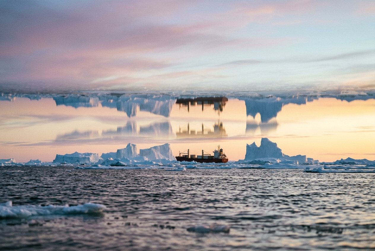
1. Opening Scene
Step out onto an arrow-straight asphalt highway slicing through the salt flats of the Mojave Desert at two o’clock on a windless August afternoon. The ambient air registers a blistering 43°C, but down against the tar, where radiant solar flux has baked the dark binder for six unbroken hours, the ground temperature hovers past 68°C. A physical oppression weighs on the skin; the air smells of volatile hydrocarbons, scorched dust, and dry silica. Half a mile down the road, an astonishing feature materialises: the black road surface appears to have dissolved into a pool of mercury-clear water, rippling with silver brilliance and reflecting the headlights of an approaching freight lorry.
Yet, as the vehicle advances, the water does not splash. It retreats. The vehicle’s front bumper is curiously clipped, mirrored downward as though cruising across a lake suspended three inches above the roadbed.
       [ Observer Eye ]
             \
              \  Direct Sightline (Sky / Object)
               \
  ----------------\-----------------------------  Warm Air (High Speed)
                   \~~~~~.
                          ' - - _  Curved Ray Path
  ================================= ======= ====  Blistering Ground (Lowest Density)
   [ Apparent Water / Reflected Sky Pool ]
Now shift the scene two thousand miles north to the jagged coastal waters of the Gulf of Maine in late November. The ocean water is a frigid 4°C, while an unseasonable, high-pressure tongue of continental air at 16°C glides quietly over the sea surface. The breeze has dropped to a dead calm; the sea is oily glass, smelling of salt spray, kelp, and cold stone.
Looking through binoculars toward an island known to lie sixteen nautical miles distant—normally sunken well below the geometric horizon due to Earth’s curvature—the landscape undergoes an uncanny metamorphosis. The low granite ledge has climbed out of the ocean. It looms upward like a sheer, vertical cliff of basalt. Segments of the island appear stacked atop one another like rectangular masonry blocks, while the distant mast of a fishing trawler stretches into an impossible spire, severed from its hull and floating suspended in the slate-grey sky.
These are not psychological hallucinations or tricks of an exhausted mind. They are pure, deterministic classical physics enacted on an open-air stage: the phenomena of inferior mirages, superior mirages, and the legendary Fata Morgana.
2. What’s Actually Happening — Plain English First
To understand why the horizon warps, we must first abandon the comforting fiction that light always travels in perfectly straight lines. Light only moves in a straight line if the medium through which it passes is completely uniform. The moment light encounters variations in the medium, its path bends.
Think of the atmosphere as a tiered cake. Each horizontal layer of air possesses a distinct temperature and pressure, which together determine its density. Cold air is packed with tightly clustered nitrogen and oxygen molecules; hot air is expanded, its molecules pushed farther apart. When a beam of light travels through dense, cold air, it encounters many molecules, interacting with their electromagnetic fields, which slows the light down ever so slightly. In hot, rarefied air, light encounters fewer molecules and travels noticeably faster.
Cold, Dense Air (Crowded Molecules)   --> Light Travels Slower
--------------------------------------------------------------
Warm, Thin Air (Spaced Molecules)      --> Light Travels Faster
Here enters Fermat’s Principle of Least Time. When light journeys from an object (a patch of blue sky or a distant island) to your eye, nature chooses the trajectory that takes the least time, not the shortest physical distance.
Imagine pushing a mechanical lawnmower across a flat lawn where half the grass is short and dry, but the other half is thick, wet mud. If you push the mower at an angle across the boundary, the right wheel hits the mud first and slows down, while the left wheel is still spinning fast on dry grass. The mower automatically swerves toward the muddy side.
Light behaves identically. When a wavefront encounters a vertical gradient where air is cold on top and hot on the bottom, the lower portion of the wavefront races ahead while the upper portion drags. The ray bends smoothly upward, away from the scorching ground.
                       WAVEFRONT REFRACTION

       Cold Air (Slow)     [ ===\           ]   Upper edge drags
                                 \
       Warm Air (Fast)     [ =====\         ]   Lower edge races ahead
                                   ' ------->   Ray curves upward!
When you stand on a hot highway, your eye receives light rays originating from the blue sky that have dipped down toward the hot road and curved back up into your retinas. Because the human visual cortex instinctively assumes light travels in unbent rays, your brain traces that blue light straight backward onto the asphalt. You perceive a patch of sky sitting on the ground. Because the sky is bright, blue, and shimmered by turbulent convective plumes, your brain categorises it as water. This is an inferior mirage ("inferior" meaning the false image appears below the true object).
Conversely, when warm air sits directly over cold water—a meteorological condition known as a temperature inversion—the reverse occurs. The air closest to the surface is coldest and densest, while the air above is warmer and less dense. Light rays travelling horizontally toward you have their upper portions moving faster than their lower portions. The rays bend downward, curving along the arc of the Earth.
If this downward bending is strong enough, light originating from objects hidden far over the horizon curves around the planet's spherical bulge and drops straight into your eyes. You see landmasses, ships, and lighthouses hoisted high into the sky—an effect meteorologists call looming and towering.
3. The Science (for those who want to go deeper)
To formalise these optical gymnastics, we begin with the fundamental constitutive equation linking optics and fluid thermodynamics: the Gladstone-Dale relation.
Equation 1: The Refractive Index Gradient
In atmospheric physics, the refractive index of dry air, $n$, differs from unity by a tiny fraction called refractivity, which is directly proportional to air density $\rho$:
$$n - 1 = k \cdot \rho$$
where $k \approx 2.26 \times 10^{-4} \text{ m}^3/\text{kg}$ is the Gladstone-Dale constant for visible light (at a reference wavelength of $\lambda \approx 550\text{ nm}$). Invoking the ideal gas equation of state, $\rho = \frac{P}{R_d T}$ (where $P$ is atmospheric pressure in Pascals, $T$ is absolute temperature in Kelvin, and $R_d = 287.05 \text{ J}/(\text{kg}\cdot\text{K})$ is the specific gas constant for dry air), we can express refractivity as:
$$n - 1 = \frac{k P}{R_d T} = c \frac{P}{T}$$
where $c = \frac{k}{R_d} \approx 7.87 \times 10^{-7} \text{ K}/\text{Pa}$ (or $7.87 \times 10^{-5} \text{ K}/\text{hPa}$).
To find how $n$ changes with vertical height $z$, we compute the total derivative with respect to altitude:
$$\frac{dn}{dz} = \frac{\partial n}{\partial P}\frac{dP}{dz} + \frac{\partial n}{\partial T}\frac{dT}{dz} = \frac{c}{T}\frac{dP}{dz} - \frac{c P}{T^2}\frac{dT}{dz}$$
Under hydrostatic equilibrium, the vertical pressure gradient is governed by the hydrostatic equation $\frac{dP}{dz} = -\rho g = -\frac{P g}{R_d T}$, where $g \approx 9.81 \text{ m}/\text{s}^2$. Substituting this relation yields the master equation for the vertical refractive index gradient:
$$\frac{dn}{dz} = -\frac{c P}{T^2} \left[ \frac{g}{R_d} + \frac{dT}{dz} \right]$$
This equation tells us that the vertical variation of optical density is dictated by a tug-of-war between the barometric pressure drop ($\frac{g}{R_d} \approx +0.0342 \text{ K}/\text{m} = +3.42^\circ\text{C}/100\text{ m}$) and the actual environmental temperature lapse rate ($\frac{dT}{dz}$).
+-----------------------------------------------------------------------------------+
| MASTER GRADIENT RELATION                                                          |
|                                                                                   |
|      dn/dz = - (c * P / T^2) * [ (g / R_d) + (dT/dz) ]                            |
|                                                                                   |
| where:                                                                            |
|   c = 7.87 x 10^-7 K/Pa                                                           |
|   g / R_d = 0.0342 K/m (the autobarotropic density gradient threshold)            |
|   dT/dz = Environmental temperature gradient (K/m)                                |
+-----------------------------------------------------------------------------------+
Worked Example: Standard Atmosphere vs. Desert Superadiabatic Layer
Let us evaluate $\frac{dn}{dz}$ under two drastically different field conditions:
- The ICAO Standard Atmosphere: Sea-level pressure $P = 1013.25\text{ hPa} = 101,325\text{ Pa}$, surface temperature $T = 288.15\text{ K}$ (15°C), and a standard tropospheric lapse rate $\frac{dT}{dz} = -0.0065\text{ K}/\text{m}$ ($-0.65^\circ\text{C}/100\text{ m}$).
$$\frac{c P}{T^2} = \frac{(7.87 \times 10^{-7}\text{ K}/\text{Pa})(101,325\text{ Pa})}{(288.15\text{ K})^2} \approx 9.60 \times 10^{-7}\text{ m}^{-1}$$
$$\frac{dn}{dz} = -9.60 \times 10^{-7} \left[ 0.0342 - 0.0065 \right] = -9.60 \times 10^{-7} \times 0.0277 \approx -2.66 \times 10^{-8}\text{ m}^{-1}$$
Because $\frac{dn}{dz}$ is negative, the atmosphere's refractive index decreases with height. Light rays curve gently downward, extending our visual horizon by roughly 8% beyond the geometric line-of-sight.
- The Desert Boundary Layer (Inferior Mirage): Over radiant asphalt, temperature drops violently across the lowest 20 centimetres: $\frac{dT}{dz} = -10.0\text{ K}/\text{m}$.
$$\frac{dn}{dz} = -9.60 \times 10^{-7} \left[ 0.0342 - 10.0 \right] = -9.60 \times 10^{-7} \times (-9.9658) \approx +9.57 \times 10^{-6}\text{ m}^{-1}$$
Here, $\frac{dn}{dz}$ flips sign to a large positive value. The refractive index increases sharply with height. Light rays bend powerfully upward with a radius of curvature of only a few hundred metres, forming the glistening highway mirage.
The Ray Path Curvature and the Earth's Radius
According to the differential equations of atmospheric refraction, the curvature $\kappa$ (the reciprocal of the radius of curvature $R_c$) of a nearly horizontal light ray is given by:
$$\kappa = \frac{1}{R_c} \approx -\frac{dn}{dz}$$
The Earth itself is a sphere with mean radius $R_E \approx 6,371,000\text{ m}$. Its surface curvature is:
$$\kappa_E = \frac{1}{R_E} \approx \frac{1}{6.371 \times 10^6\text{ m}} \approx 1.57 \times 10^{-7}\text{ m}^{-1}$$
If the downward curvature of a light ray ($\kappa$) matches the curvature of the Earth ($\kappa_E$), the light ray will orbit the globe at a constant elevation, turning the planet into a giant optical waveguide.
                   RAY CURVATURE REGIMES

   Ray Curvature (kappa) vs Earth Curvature (kappa_E = 1/R_Earth)

1. kappa < 0 (dn/dz > 0)           : Upward bending (Inferior mirage)
   2. 0 < kappa < kappa_E             : Sub-refraction (Standard horizon extension)
   3. kappa = kappa_E                 : Flat ray relative to Earth (Optical ducting threshold)
   4. kappa > kappa_E                 : Super-refraction / Looming (Superior mirage)
Equation 2: The Critical Inversion Gradient for Optical Ducting
What temperature inversion strength $\frac{dT}{dz}$ is required to bend a horizontal light ray precisely around the curve of the Earth?
We set $\kappa = \kappa_E$, which requires:
$$\frac{dn}{dz} = -\frac{1}{R_E} = -1.57 \times 10^{-7}\text{ m}^{-1}$$
Equating this to our master gradient formula:
$$-\frac{c P}{T^2} \left[ \frac{g}{R_d} + \left(\frac{dT}{dz}\right)_{\text{crit}}\right] = -1.57 \times 10^{-7}\text{ m}^{-1}$$
Solving for $\left(\frac{dT}{dz}\right)_{\text{crit}}$:
$$\left(\frac{dT}{dz}\right)_{\text{crit}} = \frac{1.57 \times 10^{-7}}{\frac{c P}{T^2}} - \frac{g}{R_d}$$
Worked Example: Calculating the Ducting Inversion
Taking surface conditions $P = 1013.25\text{ hPa}$ and $T = 288.15\text{ K}$, where $\frac{c P}{T^2} \approx 9.60 \times 10^{-7}\text{ m}^{-1}$:
$$\left(\frac{dT}{dz}\right)_{\text{crit}} = \frac{1.57 \times 10^{-7}\text{ m}^{-1}}{9.60 \times 10^{-7}\text{ m}^{-1}\text{K}^{-1}} - 0.0342\text{ K}/\text{m}$$
$$\left(\frac{dT}{dz}\right)_{\text{crit}} = 0.1635\text{ K}/\text{m} - 0.0342\text{ K}/\text{m} = +0.1293\text{ K}/\text{m}$$
$$\left(\frac{dT}{dz}\right)_{\text{crit}} \approx +12.9^\circ\text{C} \text{ per } 100\text{ metres} \quad (+0.13^\circ\text{C}/\text{m})$$
Whenever a marine boundary layer or polar ice sheet produces a temperature inversion exceeding $+0.13^\circ\text{C}$ per metre of elevation gain, terrestrial light enters an atmospheric duct. Light cannot escape into space; it is trapped against the surface, bending tighter than the Earth's sphere.
+-----------------------------------------------------------------------------------+
| CRITICAL METEOROLOGICAL THRESHOLDS                                                |
|                                                                                   |
| * dT/dz = -3.42°C / 100m  -> dn/dz = 0 (Light travels in true Euclidean lines)   |
| * dT/dz = -0.65°C / 100m  -> Standard refraction (Earth looks 8% flatter)         |
| * dT/dz = +12.9°C / 100m  -> Optical Ducting (R_ray = R_Earth; horizon vanishes) |
| * dT/dz > +13.0°C / 100m  -> Superior Mirages & Severe Looming                    |
+-----------------------------------------------------------------------------------+
The Architecture of the Fata Morgana
When the vertical profile contains multiple inflection points—meaning $\frac{d^2n}{dz^2} \neq 0$, such as an S-shaped thermal inversion profile where a steep inversion layer is sandwiched between two standard lapse layers—the atmosphere transforms into an imperfect cylindrical lens system.
Light rays emitted from different vertical elevations of a distant ship or coastline cross one another before reaching the observer's eye (a condition known mathematically as an optical caustic).
The observer sees a complex, vertically dynamic composite image: alternating upright and inverted segments. Flat coastlines are magnified vertically (towering), squashed into slivers (stooping), and elevated into the sky (looming). This dramatic, ever-shifting optical tapestry is the classic Fata Morgana, named after the Arthurian enchantress Morgan le Fay.
4. Practical Outdoor Guidance
One does not need an optical laboratory to witness and measure these phenomena. Armed with an understanding of boundary-layer meteorology, any hiker, coastal walker, or amateur astronomer can turn the outdoors into an active experiment.
       SUPERIOR MIRAGE / TOWERING RAY TRACE

  Warm Inversion Air (Low Density)
  ---------------------------------------------------------
                                 . - - - .  Inverted Ray
                             . '           ' .
  Cold Surface Air       . '                   ' .
  ===================[ Ship ]====================[ Observer ]==
  Curved Earth Horizon
What to Look for in the Sky and on the Horizon
- False Shorelines & Hovering Ships (Coastal Waters): When observing a maritime horizon over cold water in spring or early summer, look for ships whose superstructures appear detached from their hulls. If the hull is invisible while the mast appears tripled or stretched like a chimney, you are witnessing towering within an optical duct.
- The "Disappearing Horizon" (The Novaya Zemlya Effect): In high-latitude or desert winter environments, an intense inversion can compress the horizon into an elevated horizontal band, occasionally allowing the Sun to appear several days before its astronomical equinox return—an extreme form of superior refraction documented by polar explorers and catalogued by the World Meteorological Organization.
- Pavement Shimmer vs. Clean Inversion: Inferior mirages require high thermal turbulence. Look for rapid, chaotic scintillation (shimmer) right above dark surfaces. Superior mirages, by contrast, require quiescent, laminar airflow; they appear eerily steady and crisp through telephoto optics.
+----------------------------------------------------------------------------------+
| OBSERVER'S FIELD MATRIX                                                          |
+----------------------+-----------------------------+-----------------------------+
| PARAMETER            | INFERIOR MIRAGE             | SUPERIOR MIRAGE / DUCTING   |
+----------------------+-----------------------------+-----------------------------+
| Surface Condition    | Hotter than air (Asphalt/Sand)| Colder than air (Cold sea)  |
| Lapse Rate (dT/dz)   | Strongly negative (< -3.4°C/100m) | Strongly positive (> +13°C/100m)|
| Ray Curvature        | Concave UPWARD              | Concave DOWNWARD            |
| Image Location       | Inverted image BELOW object | Inverted/upright ABOVE      |
| Typical Stability    | Highly unstable, turbulent  | Exceptionally stable/laminar|
+----------------------+-----------------------------+-----------------------------+
Instrument Readings to Monitor
- The Barometer: High-pressure systems (anticyclones) produce strong regional subsidence (sinking dry air), which suppresses cloud cover and sets up strong radiational cooling at night—prime breeding grounds for surface inversions.
- The Thermometer (Surface vs. Eye-Level): Carry an infrared non-contact thermometer alongside a standard ambient thermometer. If your infrared sensor measures the ground surface at $\ge 15^\circ\text{C}$ hotter than ambient air at eye level, look immediately for inferior mirages along low sightlines. If a cold water surface is $\ge 5^\circ\text{C}$ colder than air at two metres altitude, look for superior refraction.
- The Anemometer: Optical stratification is fragile. Wind speeds exceeding $5\text{ to }7\text{ knots}$ generate mechanical wind shear and turbulent eddies, mixing the boundary layer and destroying the steep $\frac{dn}{dz}$ gradient. Mirages thrive in total calms.
A Simple Rule of Thumb for Hikers and Mariners
Change your eye height. Because atmospheric mirages depend sensitively on the observer's line-of-sight angle through thin boundary layers (often only tens of centimetres thick), changing your elevation dramatically alters the ray geometry.
- If you see an inferior mirage shimmer on a desert track, crouch down: dropping your eye closer to the surface lengthens the optical path through the superadiabatic layer, making the reflected sky patch wider and more distinct.
- If you are scanning a cold coastline for distant floating islands, climb an embankment or ship's mast: ascending moves your line of sight into the capping inversion layer, shifting you from a trapped duct perspective to a towering superior profile.
5. Today's Meteorological Rule of Thumb
+-----------------------------------------------------------------------------------+
| TODAY'S METEOROLOGICAL RULE OF THUMB                                              |
|                                                                                   |
| Cold air below makes the horizon grow; hot air below makes the blue sky show.    |
|                                                                                   |
| When the ground is colder than the air by 13°C per hundred metres, light bends   |
| with the planet, lifting distant lands into view; when the ground is blistering,   |
| light bends upward, splashing the sky across the earth.                           |
+-----------------------------------------------------------------------------------+
Explore further meteorological resources and observational databases via the National Oceanic and Atmospheric Administration (NOAA), the Met Office Educational Optics Portal, and the WMO International Cloud Atlas Guide on Meteors.