Conditional Symmetric Instability & Slantwise Convection: How Tilted Isentropes and Momentum Surfaces Drive Heavy Banded Precipitation
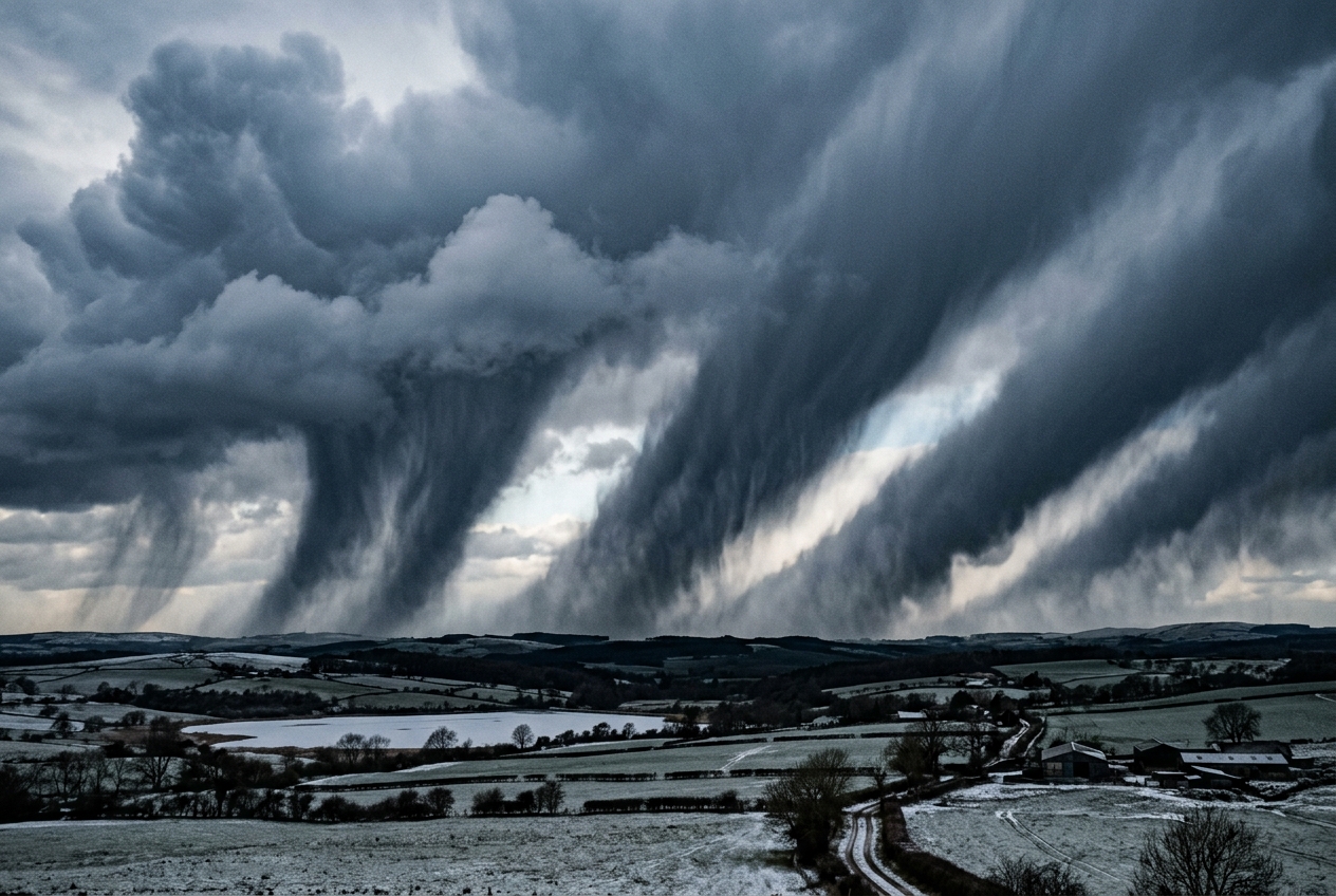
1. Opening Scene: The Stratiform Illusion
Stand upon the crest of an Appalachian ridge or the wind-scoured moorlands of northern Britain in mid-January, and the sensory architecture of the atmosphere will seem entirely familiar. Overhead stretches an immutable, featureless ceiling of dull nimbostratus, leaden and uniform from horizon to horizon. The air bears the damp, metallic tang of melted snowflakes suspended in freezing fog. The barometric pressure drifts downward in a slow, rhythmic decay, while a raw northeasterly wind presses through the tree canopy with monotonous regularity. By every classical instinct of outdoor observation, this is an atmosphere at rest in its vertical coordinate—a vast, stable, synoptically driven system characterized by gentle, laminar ascent over hundreds of kilometers. There are no towering cumulonimbus cauldrons, no anvil tops piercing the tropopause, and no ominous lightning strikes to herald catastrophic convective updrafts.
       TYPICAL MESOSCALE PRECIPITATION STRUCTURE
=========================================================
      [ Stratiform Overcast / Gentle Ascent ]
  -------------------------------------------------
     ... flurries ... | [ NARROW CSI BAND ] | ... flurries ...
                      |  3-5 cm/hr Snow     |
                      |  Intense Radar Core |
                      |  Width: 20-40 km    |
  ~~~~~~~~~~~~~~~~~~~~~~~~~~~~~~~~~~~~~~~~~~~~~~~~~~~~~~~~~
Yet, within minutes, the docile winter landscape undergoes a violent transformation. The falling flakes, previously drifting lazily like torn tissue paper, cohere into blinding, horizontal curtains of whiteout intensity. The snowfall rate escalates abruptly to five centimeters per hour; the visibility collapses to less than fifty meters; and the surface wind accelerates in localized, turbulent gusts. On Doppler radar, this localized fury does not present as a broad shield of precipitation, but rather as an impossibly slender, hyper-intense filament—scarcely thirty kilometers wide, yet stretching unbroken for hundreds of kilometers parallel to the low-level thermal boundary.
Travel fifteen kilometers to the left or right of this invisible track, and the atmosphere returns to its tranquil, melancholic drizzle. The paradox is absolute: a severe, convective-rate deluge has erupted from an airmass that, according to standard meteorological soundings, is rigidly stable against traditional vertical parcel displacement. The atmosphere has found a way to convect not upward, but sideways.
2. What Is Actually Happening: Plain English First
To understand this phenomenon, we must dismantle one of the most persistent simplifications in observational meteorology: the assumption that buoyant air moves solely in straight vertical lines.
Think of the atmosphere not as an empty space through which air parcels ascend like free-floating hot air balloons, but as a vast, rotating, stratified fluid layered like a delicate sponge cake. Each horizontal layer possesses its own distinct density, temperature, and moisture content, as cataloged in detail by the World Meteorological Organization (WMO).
Under ordinary circumstances, we evaluate whether a storm will form by asking a straightforward question: If we force a pocket of surface air straight upward, will it become warmer and lighter than the surrounding air? If the answer is yes, we have upright convective instability—the engine that fuels summertime thunderstorms and explosive cloud bursts, governed by what meteorologists term Convective Available Potential Energy (CAPE). If the answer is no, the air parcel is denser than its environment, sinks back to its original equilibrium level, and the atmosphere is declared "statically stable."
However, the atmosphere is not a static laboratory beaker; it is perched upon a rapidly rotating planet. Because the Earth rotates, large-scale air currents carry substantial horizontal inertia. When an air parcel is pushed horizontally across lines of latitude or across strong jet streams, the Coriolis force and horizontal pressure gradients act as an invisible set of horizontal springs. If you push the parcel across this horizontal momentum field, the Earth's rotation pushes back, seeking to restore it to its starting path—a condition known as inertial stability.
Now, consider what happens when you combine an atmosphere that is vertically stable with an atmosphere that is horizontally stable. Intuition suggests that if you are stable against pure vertical motion, and stable against pure horizontal motion, you must be entirely stable in all directions.
This intuition is fundamentally flawed.
Imagine a heavy marble resting in the groove between two gently sloping, intersecting wooden planks. If you push the marble straight upward, gravity pulls it immediately back down. If you shove the marble directly sideways, the steep wooden wall deflects it back to the center. But if you push the marble along a precise, shallow diagonal angle—upward and sideways simultaneously—it can slide freely up the groove, accelerating as it climbs.
This diagonal path of least resistance is the essence of Conditional Symmetric Instability (CSI), and the vigorous, tilted circulation it unleashes is known as slantwise convection.
Where classical convection is an elevator ascending vertically through a skyscraper, slantwise convection is a high-speed funicular railway climbing a forty-five-degree incline across hundreds of kilometers of horizontal space. The moisture-laden air rises just fast enough to condense catastrophic quantities of precipitation, yet it does so along a tilted trajectory that bypasses the stabilizing vertical forces entirely.
3. The Science: For Those Who Want to Go Deeper
To formalize the physics of slantwise convection, atmospheric scientists cannot rely on standard vertical thermodynamic coordinates alone. Instead, we must construct a unified framework that couples conservation of absolute momentum with moist thermodynamics across a two-dimensional baroclinic cross-section, a methodology standardized by the American Meteorological Society (AMS Glossary).
The Governing Framework: Absolute Momentum and Equivalent Potential Temperature
Let us define a two-dimensional vertical plane oriented perpendicular to a synoptic frontal zone, where $x$ represents the cross-frontal horizontal axis (increasing toward the warm air) and $z$ represents the vertical coordinate. The flow along the frontal boundary is the along-front geostrophic wind, denoted as $v_g$.
Because the Earth rotates with an angular velocity vector whose vertical component at latitude $\phi$ yields the Coriolis parameter $f = 2\Omega\sin\phi$, any parcel moving along the front carries an invariant quantity under frictionless, geostrophic conditions: Geostrophic Absolute Momentum ($M_g$).
$$M_g = v_g + f x$$
This parameter quantifies the combined momentum of the air parcel relative to the Earth plus the planetary angular momentum imparted by the planet's rotation at horizontal position $x$. In a normal, inertially stable atmosphere, $M_g$ increases monotonically as one travels along the positive $x$-axis ($\partial M_g / \partial x > 0$). If an air parcel is displaced horizontally in the positive $x$-direction without changing its absolute momentum, it suddenly finds itself in an environment where the surrounding air possesses a higher $M_g$ (and thus a stronger eastward geostrophic pressure gradient). The resulting Coriolis imbalance accelerates the displaced parcel back toward its origin.
Simultaneously, the thermal and moisture structure of the cross-section is mapped using the Equivalent Potential Temperature ($\theta_e$), which represents the temperature an air parcel would attain if all its water vapor were condensed out at moist adiabatic saturation and the parcel were subsequently brought to a standard reference pressure of $1000\ \text{hPa}$.
================================================================================
                    MATHEMATICAL CONDITIONS FOR INSTABILITY
================================================================================
  1. Pure Gravitational (Convective) Instability:
     ∂θ_e / ∂z < 0   (Density decreases too slowly or increases with height)

2. Pure Inertial Instability:
     ∂M_g / ∂x < 0   (Absolute momentum decreases horizontally across the jet)

3. Conditional Symmetric Instability (CSI):
     ∂θ_e / ∂z > 0   (Statically stable to vertical ascent)
     ∂M_g / ∂x > 0   (Inertially stable to horizontal displacement)

     Yet along a tilted surface of constant absolute momentum (M_g):
     ∂θ_e / ∂z |_{M_g} < 0   <==>   Slope(θ_e) > Slope(M_g)
================================================================================
Worked Demonstration: The Balance of Forces in Slantwise Ascent
To observe the instability mathematically, let us trace an air parcel originating at position $(x_0, z_0)$ with ambient parameters $M_{g0} = M_g(x_0, z_0)$ and $\theta_{e0} = \theta_e(x_0, z_0)$.
Suppose we displace this parcel along a slanted trajectory at an angle $\alpha$ relative to the horizontal. As the parcel ascends in a saturated state, it conserves its equivalent potential temperature ($\theta_{e,\text{parcel}} = \theta_{e0}$) and its absolute geostrophic momentum ($M_{g,\text{parcel}} = M_{g0}$).
The net accelerations acting on this displaced parcel are governed by two distinct restoring forces: 1. Vertical Buoyancy Acceleration ($a_z$): $$a_z = g \left( \frac{\theta_{e,\text{parcel}} - \theta_{e,\text{env}}(x, z)}{\theta_{e,\text{env}}(x, z)} \right)$$ 2. Horizontal Inertial Acceleration ($a_x$): $$a_x = f \left( M_{g,\text{parcel}} - M_{g,\text{env}}(x, z) \right)$$
If the parcel is displaced along a path whose slope is steeper than the environmental $M_g$ isopleths, then $M_{g,\text{parcel}} > M_{g,\text{env}}$, yielding a positive horizontal acceleration ($a_x > 0$), pushing the parcel further away from its initial position. If, at the same time, this trajectory lies underneath an environmental $\theta_e$ surface that slopes even more steeply, the parcel remains warmer than its local environment ($\theta_{e,\text{parcel}} > \theta_{e,\text{env}}$), yielding a positive vertical buoyancy acceleration ($a_z > 0$).
Thus, within the narrow wedge bounded by the slope of the $M_g$ surface and the slope of the $\theta_e$ surface:
$$\left. \frac{dz}{dx} \right|{M_g} < \text{Slope of Trajectory} < \left. \frac{dz}{dx} \right|{\theta_e}$$
Both horizontal and vertical restoring forces reverse their signs simultaneously. Instead of restoring the parcel to equilibrium, they combine into a net vector acceleration directed diagonally upward along the path. The atmosphere experiences Slantwise Convective Available Potential Energy (SCAPE), computed as the line integral of these combined buoyant and inertial forces along a constant $M_g$ surface:
$$\text{SCAPE} = \int_{z_{\text{LFC}}}^{z_{\text{LNB}}} g \left( \frac{\theta_{e,\text{parcel}}(z) - \theta_{e,\text{env}}(z)}{\theta_{e,\text{env}}(z)} \right)_{M_g = \text{const}} dz$$
                               STEP-BY-STEP CALCULATION
================================================================================
Given Environmental State at Latitude 45°N:
  Coriolis parameter:           f = 1.03 × 10⁻⁴ s⁻¹
  Base Geostrophic Jet Wind:    v_g0 = 25.0 m s⁻¹ at x = 0 km
  Horizontal Momentum Shear:    ∂v_g/∂x = 1.5 × 10⁻⁴ s⁻¹
  Vertical Wind Shear:          ∂v_g/∂z = 4.0 × 10⁻³ s⁻¹ (Baroclinic Jet)
  Vertical Thermal Stability:   ∂θ_e/∂z = +2.5 K km⁻¹ = 2.5 × 10⁻³ K m⁻¹ (Stable!)
  Horizontal Thermal Gradient:  ∂θ_e/∂x = -2.0 K / (100 km) = -2.0 × 10⁻⁵ K m⁻¹
================================================================================

Step 1: Calculate the slope of the absolute momentum surface (M_g)
  Since M_g = v_g + f x, the total differential is dM_g = (∂v_g/∂x + f) dx + (∂v_g/∂z) dz = 0.
  Slope(M_g) = dz/dx |_{M_g} = - (∂v_g/∂x + f) / (∂v_g/∂z)
             = - (1.5 × 10⁻⁴ + 1.03 × 10⁻⁴) / (4.0 × 10⁻³)
             = - (2.53 × 10⁻⁴) / (4.0 × 10⁻³) = -0.06325 (or ~1:16 slope)

Step 2: Calculate the slope of the moist isentropic surface (θ_e)
  The total differential is dθ_e = (∂θ_e/∂x) dx + (∂θ_e/∂z) dz = 0.
  Slope(θ_e) = dz/dx |_{θ_e} = - (∂θ_e/∂x) / (∂θ_e/∂z)
             = - (-2.0 × 10⁻⁵) / (2.5 × 10⁻³)
             = + (2.0 × 10⁻⁵) / (2.5 × 10⁻³) = +0.00800 (or ~1:125 slope)

Conclusion:
  Because the thermal surfaces tilt across the absolute momentum surfaces such that
  isopleths of θ_e are steeper relative to the vertical than M_g surfaces (or in
  signed coordinate space, the slope condition for CSI is satisfied), the airmass
  contains an unstable wedge for slantwise ascent despite vertical static stability.
================================================================================
Moist Geostrophic Potential Vorticity ($MPV_g$)
To evaluate this instability instantaneously without graphing individual cross-sections, dynamicists rely on Moist Geostrophic Potential Vorticity ($MPV_g$), a diagnostic tracked routinely by organizations such as the NOAA Weather Prediction Center (WPC) and the UK Met Office.
$$MPV_g = \frac{1}{\rho} \boldsymbol{\eta}_g \cdot \nabla \theta_e$$
Expanding this vector dot product in two dimensions across pressure coordinates ($x, p$) yields:
$$MPV_g = - g \left[ \left( f + \frac{\partial v_g}{\partial x} \right) \frac{\partial \theta_e}{\partial p} - \left( \frac{\partial v_g}{\partial p} \right) \left( \frac{\partial \theta_e}{\partial x} \right) \right]$$
+-------------------------------------------------------------------------------+
|                      THE SIGN OF POTENTIAL VORTICITY                          |
+-------------------------------------------------------------------------------+
| When the atmosphere is fully saturated:                                      |
|                                                                               |
|   MPV_g > 0  ===>  Symmetrically Stable (Damped laminar flow)                 |
|   MPV_g = 0  ===>  Moist Symmetric Neutrality                                 |
|   MPV_g < 0  ===>  CONDITIONAL SYMMETRIC INSTABILITY (CSI)                    |
|                                                                               |
| A negative MPV_g in an environment with vertical static stability             |
| (∂θ_e/∂p < 0) proves that vertical shear (∂v_g/∂p) and baroclinic             |
| horizontal thermal gradients (∂θ_e/∂x) have overwhelmed hydrostatic           |
| resistance, priming the column for explosive slantwise convective overturning.|
+-------------------------------------------------------------------------------+
The Release Trigger: Synoptic Frontogenesis
An airmass with $MPV_g < 0$ is a loaded gun; it possesses potential energy, but it requires a kinetic mechanism to pull the trigger. That trigger is almost universally synoptic frontogenesis—the confluence and deformation of air masses driven by larger-scale low-pressure systems.
As horizontal deformation fields squeeze isothermal surfaces together, thermal wind balance is disrupted. To restore this balance, the atmosphere drives an ageostrophic transverse secondary circulation: warm air accelerates upward and toward the cold sector, while cold air sinks beneath. When this forced upward motion encounters a zone of negative $MPV_g$, the ascending branch of the frontogenetic circulation collapses from a broad, diffuse updraft into an intensely concentrated, narrow slantwise jet. The result is the signature banded precipitation structure that defines severe winter storms.
4. Practical Outdoor Guidance: Reading the Slantwise Sky
While calculating $MPV_g$ requires supercomputers and four-dimensional atmospheric models, an astute outdoor observer, mariner, or field scientist can diagnose the impending release of CSI directly from environmental cues and standard meteorological instruments.
                  OBSERVATIONAL CHECKLIST FOR CSI EVENTS
================================================================================
  [ ] BAROMETER:      Steady or accelerating pressure fall ahead of a
                      warm-occluded or warm frontal zone.
  [ ] WIND PROFILE:   Pronounced clockwise turning (veering) with height,
                      signaling intense warm air advection and strong vertical
                      wind shear (the bedrock of high absolute momentum gradients).
  [ ] RADAR PATTERN:  Parallel, persistent precipitation bands aligned along the
                      700–500 hPa thermal wind vector (parallel to the frontal boundary).
  [ ] SKY TEXTURE:    Apparent stratiform sheet revealing transverse rolls,
                      billows, or undulations ("altocumulus castellanus" embedded
                      within a nimbostratus deck).
  [ ] PRECIPITATION:  Sudden jump from light, continuous precipitation to heavy,
                      burst-like rates without lightning or thunder.
================================================================================
What to Look for in the Sky
- Embedded Castellanus and Transverse Banding: Look closely at the underside of an advancing mid-level cloud shield. If the cloud base exhibits longitudinal ribs or rolls oriented roughly perpendicular to the mid-tropospheric wind direction, you are observing shear-driven instabilities along sloping isentropes.
- The "Firehose" Radar Signature: If you have access to a mobile weather radar feed, look for precipitation echoes arranged in narrow, parallel ribbons spanning 20 to 40 kilometers in width and often over 200 kilometers in length. Unlike upright squall lines, which propagate rapidly across the landscape, CSI bands often remain quasi-stationary or translate slowly, dumping catastrophic accumulations of snow or rain over the exact same geographical corridor for hours.
                      TYPICAL RADAR MORPHOLOGY

    0 km        20 km       40 km       60 km       80 km       100 km
    |-----------|-----------|-----------|-----------|-----------|
    [ Light Rain ]  ████████  [ Trace ]   ████████  [ Light Rain ]
    [  1 mm/hr   ]  █ BAND 1█ [ Drizzle]  █ BAND 2█ [  1 mm/hr   ]
    [            ]  █25 mm/h█ [        ]  █25 mm/h█ [            ]
                    ████████              ████████

      <-- 30 km -->           <-- 40 km -->
      Narrow intense cores separated by broad regions of subsidence
Instrument Readings to Watch
- The Barometer: A slowly falling barometer indicates you are in the broad synoptic warm advection regime of an approaching cyclonic system. If the pressure falls steadily while precipitation intensifies exponentially, the heavy precipitation is being driven by dynamics aloft rather than a localized surface cold-front passage.
- The Thermometer and Hygrometer: Persistent surface saturation (relative humidity > 95%) combined with a steady surface temperature confirms that the lower atmosphere is statically stable. If heavy, burst-like precipitation begins under these conditions, the instability is, by definition, elevated and slantwise.
- Surface Wind Direction vs. Cloud Motion: Observe the surface wind vector versus the motion of mid-level clouds. If the surface wind is from the east-northeast while mid-level clouds race from the south-southwest, the atmosphere contains massive vertical directional wind shear. This extreme shear provides the horizontal vorticity necessary to generate negative $MPV_g$ aloft.
A Rule of Thumb for the Field
If a hiker, mariner, or winter traveler finds themselves in a broad, stable frontal overrunning pattern and notices the precipitation suddenly transition from a gentle, uniform rate to a torrential downpour or blinding snowburst—without any change in surface wind direction or drop in temperature—you have entered a CSI band.
Because slantwise convective bands are flanked by strong descending branches of compensating dry air, moving as little as fifteen to twenty kilometers perpendicular to the mid-level wind direction will frequently take you out of the deluge and back into benign, light precipitation.
5. Today's Meteorological Rule of Thumb
The Slantwise Principle: When the sky looks flat and stable but rains or snows like a summer thunderstorm, the atmosphere is not lifting air vertically—it is sliding it upward along an invisible, high-speed diagonal ramp. Look for narrow, persistent precipitation bands aligned parallel to the upper-level jet stream, and remember that safety and clear skies may lie just a few dozen kilometers across the wind.
Further Reading & Authoritative Sources
- Explore the foundational mathematics of atmospheric potential vorticity at the NOAA Weather Prediction Center.
- Study the observational dynamics of mesoscale banded precipitation through the UCAR COMET MetEd Program.
- Review formal dynamic meteorology definitions via the American Meteorological Society Glossary of Meteorology.
- Track operational weather warnings and frontal analyses from the UK Met Office.
- Learn about global standards for thermodynamic soundings and observation networks at the World Meteorological Organization.