Katabatic Winds & Gravitational Drainage: How Radiative Surface Chilling Unleashes High-Velocity Downslope Gales
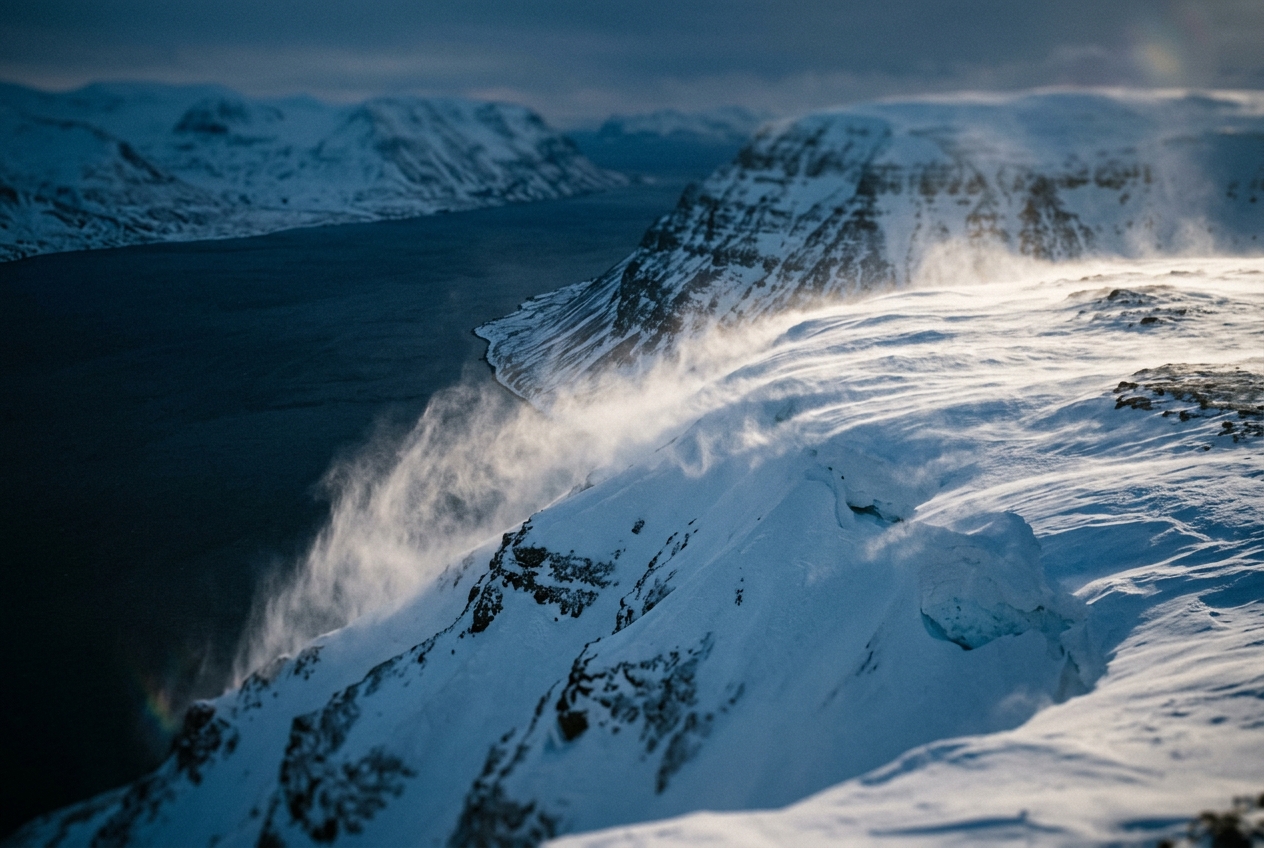
1. The Midnight Avalanche of Air
At 2,800 metres in the Bernese Oberland, midnight arrives with the deceptive tranquility peculiar to high-pressure alpine weather. The sky is an unblemished, indigo vault; the stars are needles of unwavering light, untroubled by the atmospheric scintillation that signals high-altitude turbulence. In the snow-filled col where a mountaineer might pitch a high-altitude bivouac, the air at 22:00 is dead calm. The mercury in the sling psychrometer rests at a manageable $-4^\circ\text{C}$. The silence is absolute, punctuated only by the occasional fracture of settling firn.
Then, without any shift in the barometric synoptic chart, the world transforms.
Around 01:30, the ambient air pressure at the tent door does not plunge as it would before an Atlantic depression, yet the temperature begins a precipitous slide: $-8^\circ\text{C}$, $-14^\circ\text{C}$, $-19^\circ\text{C}$ in a matter of twenty minutes. A faint, hollow sibilance echoes from the upper cirque, like water rushing over a distant weir. Within seconds, a torrent of laminar, bone-chilling air strikes the campsite. It does not gust with the chaotic, buffeting eddies of a cyclonic front; rather, it pours down the inclined glacier like a solid sheet of heavy, freezing brine. Guy-lines hum at a sustained pitch; loose granules of rime are scoured from the crust and driven horizontally down the fall line.
Look upward toward the pass, and the stars remain perfectly crisp. There is no anvil cloud, no advancing warm sector, no squall line on the synoptic horizon. What you are standing in is an invisible river—an atmospheric drainage current known to dynamic meteorology as a katabatic wind (derived from the Greek katabatikos, meaning "descending" or "going down"). You are witnessing gravity acting directly upon thermal disparity: a vast reservoir of air, refrigerated by radiative loss against the snowpack, sliding down the topography of the Earth under its own overwhelming weight.
2. What Is Actually Happening: Gravity as a Fluid Pump
To understand why cold air drains down mountainsides with the velocity of an express train, one must first abandon the intuition that wind is driven solely by horizontal atmospheric pressure systems. While synoptic gales are steered by planetary-scale isobars and modulated by the Met Office surface pressure charts, katabatic flows are local thermodynamic heat engines running in reverse.
Think of the clear night-time atmosphere as a stratified column—a layered sponge holding heat. Under a blanket of overcast skies, the Earth’s surface radiates longwave infrared energy toward the clouds, which absorb and re-emit that heat back downward, creating a radiative equilibrium. But beneath a cloudless sky, especially over high-albedo surfaces such as alpine snowfields or continental ice sheets, the atmospheric greenhouse window stands wide open. The ground radiates thermal infrared photons directly into the $-270^\circ\text{C}$ sink of deep space.
Because dry air is largely transparent to longwave radiation, the atmosphere several hundred metres aloft remains relatively unaffected. The snow or rock surface, however, loses heat rapidly via the Stefan–Boltzmann law. Through molecular conduction and localized sensible heat transfer, a shallow skin of air directly touching the terrain is rapidly chilled.
This creates an intense, surface-based temperature inversion: the air at the surface becomes dramatically colder, and consequently denser, than the ambient free atmosphere situated at the exact same geometric altitude a few hundred metres horizontally away from the slope.
Imagine pouring a carafe of chilled, heavy cream into a tilted glass of warm water. The cream does not diffuse instantly; it forms a distinct, coherent current that hugs the bottom of the glass, accelerating down the incline beneath the lighter fluid. In the atmosphere, the cold boundary layer behaves as that dense cream. The horizontal density differential between the chilled air hugging the slope and the undisturbed ambient air over the valley creates a permanent horizontal pressure gradient force directed inward toward the mountain face. Resolved along a slope inclined at angle $\alpha$, gravity seizes this negative buoyancy deficit, pulling the entire boundary layer downhill in a continuous, self-reinforcing drainage sheet.
3. The Science: Thermodynamics and the Prandtl Slope-Flow Model
To formalize the kinematics of gravitational drainage, we treat the atmosphere using the Boussinesq approximation, wherein density variations are neglected except where they contribute directly to the buoyancy term in the momentum equation.
Governing Equations: Negative Buoyancy on an Incline
Let the terrain be an idealized planar slope inclined at an angle $\alpha$ relative to the horizontal. We establish an orthogonal coordinate system where $s$ is the coordinate directed down the slope, and $n$ is the coordinate normal (perpendicular) to the slope face.
Let $\theta_0(z)$ represent the potential temperature profile of the ambient, undisturbed atmosphere exhibiting a constant stable background stratification:
$$\gamma = \frac{\mathrm{d}\theta_0}{\mathrm{d}z} > 0$$
Let $\theta'(n) = \theta(n) - \theta_0(n)$ represent the potential temperature deficit of the near-surface air layer. Because the surface is chilled by net outgoing longwave radiation, $\theta' < 0$. The resulting negative buoyancy force per unit mass acting along the true vertical is given by Archimedes' principle:
$$b = -g \frac{\rho'}{\rho_0} \approx g \frac{\theta'}{\theta_0}$$
Projecting this vertical buoyancy acceleration along the slope-parallel axis $s$ yields the effective downslope gravitational acceleration $g'$:
The Reduced Gravity Driving Term
$$g' = g \left( \frac{\Delta \theta}{\theta_0} \right) \sin\alpha$$
- $g$: Standard gravitational acceleration ($9.81\text{ m/s}^2$)
- $\Delta \theta = |\theta'|$: Magnitude of the potential temperature deficit ($\text{K}$)
- $\theta_0$: Reference potential temperature of the ambient free atmosphere ($\text{K}$)
- $\alpha$: Angle of topographic inclination relative to the horizontal
This formulation establishes that the driving force of a katabatic wind is directly proportional to both the thermal contrast ($\Delta \theta / \theta_0$) and the sine of the terrain slope ($\sin\alpha$).
Worked Physical Example 1: Pure Gravitational Acceleration
Consider a vast outlet glacier descending from a high-altitude icefield (such as the Jostedalsbreen in Norway or an Antarctic coastal outlet): * Slope angle: $\alpha = 8^\circ$ (hence $\sin 8^\circ \approx 0.1392$) * Reference potential temperature: $\theta_0 = 270.0\text{ K}$ * Radiatively chilled near-surface inversion deficit: $\Delta \theta = 9.0\text{ K}$
Let us calculate the initial downslope acceleration $g'$ experienced by a stagnant air parcel:
$$g' = 9.81 \times \left( \frac{9.0}{270.0} \right) \times 0.1392$$
$$g' = 9.81 \times 0.03333 \times 0.1392 \approx 0.0455\text{ m/s}^2$$
If this parcel accelerated down a 4-kilometre glacial ramp without friction or drag, its theoretical terminal velocity $v = \sqrt{2 g' L}$ would be:
$$v_{\text{theoretical}} = \sqrt{2 \times 0.0455\text{ m/s}^2 \times 4000\text{ m}} = \sqrt{364} \approx 19.08\text{ m/s} \quad (68.7\text{ km/h})$$
In the natural world, however, pure frictionless acceleration never occurs. The accelerating flow immediately generates wall-bounded shear against the rough ice surface beneath it and turbulent entrainment drag against the motionless, warmer air above it.
The Prandtl (1942) Steady-State Slope-Flow Model
To find the actual velocity and temperature profiles within a fully developed katabatic boundary layer, atmospheric physicists rely on the classic analytical model formulated by Ludwig Prandtl. Under steady-state conditions ($\partial / \partial t = 0$), assuming infinite planar symmetry along the slope ($\partial / \partial s = 0$), the coupled momentum and thermodynamic energy equations balance gravitational driving forces, turbulent momentum diffusion, and background thermal advection:
Momentum Balance:       0 =  g (θ' / θ_0) sin α  +  K_m (d²u / dn²)
Thermodynamic Balance:  0 = -u γ sin α           +  K_h (d²θ' / dn²)
Here, $u(n)$ is the velocity profile down the slope, $K_m$ is the eddy viscosity, $K_h$ is the eddy thermal diffusivity (assumed equal under $Pr_t = K_m / K_h = 1$), and $\gamma = \mathrm{d}\theta_0/\mathrm{d}z$ is the ambient potential temperature lapse rate.
Combining these two second-order linear differential equations yields a single fourth-order ordinary differential equation:
$$\frac{\mathrm{d}^4 u}{\mathrm{d}n^4} + \left( \frac{g \gamma \sin^2 \alpha}{K_m K_h \theta_0} \right) u = 0$$
Defining the characteristic Prandtl length scale (the boundary layer depth scale) as:
$$\ell = \left( \frac{4 K_m K_h \theta_0}{g \gamma \sin^2 \alpha} \right)^{1/4} = \left( \frac{4 K^2}{N^2 \sin^2 \alpha} \right)^{1/4}$$
where $N = \sqrt{\frac{g}{\theta_0} \gamma}$ is the ambient Brunt–Väisälä buoyancy frequency.
Applying the physical boundary conditions: 1. No-slip and specified surface temperature deficit at the ground ($n = 0$): $u(0) = 0$, $\theta'(0) = -C$ 2. Vanishing perturbations in the free troposphere ($n \to \infty$): $u(\infty) \to 0$, $\theta'(\infty) \to 0$
The exact analytical solutions for the velocity field $u(n)$ and thermal deficit $\theta'(n)$ emerge as damped sinusoids:
The Prandtl Analytical Solutions
$$u(n) = C \left( \frac{g}{\theta_0 \gamma} \frac{K_h}{K_m} \right)^{1/2} \mathrm{e}^{-n/\ell} \sin\left(\frac{n}{\ell}\right)$$
$$\theta'(n) = -C \mathrm{e}^{-n/\ell} \cos\left(\frac{n}{\ell}\right)$$
  Height Normal to Slope (n)
    ^
    |          PRANDTL JET PROFILE
    |
    |      ..---..
    |    .'       '.
    |   /           \       <-- Maximum Jet Speed: u_max at n = (π/4) ℓ
    |  ;             ;
    |  |             |
    |  :             :
    |   \           /
    |    '.       .'
    |      ''---''
    |     /
    +----+-----------------------------> Downslope Velocity u(n)
    0  (Ground: u = 0)
The mathematical elegance of Prandtl's formulation reveals two fundamental physical properties of katabatic winds: 1. The Low-Level Jet (LLJ): The velocity does not peak at the top of the boundary layer; it peaks exceptionally close to the surface, specifically at $n_{\text{max}} = \frac{\pi}{4} \ell \approx 0.785 \ell$. 2. The Thermal Inversion Layer: The temperature deficit decays rapidly with height and undergoes a weak positive overshoot above the jet core, producing an aloft entrainment zone where turbulent shear mixes ambient heat downward.
Worked Physical Example 2: Jet Height and Peak Velocity
Let us evaluate the Prandtl equations for an overnight drainage wind in an alpine valley: * Background stratification: $\gamma = 0.005\text{ K/m}$ ($5\text{ K}$ per kilometre) * Reference temperature: $\theta_0 = 280\text{ K}$ * Slope: $\alpha = 4^\circ$ ($\sin 4^\circ \approx 0.06976$) * Effective turbulent exchange coefficient: $K_m = K_h = 0.35\text{ m}^2/\text{s}$ * Surface temperature deficit: $C = |\theta'(0)| = 6.0\text{ K}$
Step 1: Compute the Brunt–Väisälä Frequency ($N$)
$$N = \sqrt{\frac{9.81}{280} \times 0.005} = \sqrt{0.03504 \times 0.005} = \sqrt{0.0001752} \approx 0.01324\text{ s}^{-1}$$
Step 2: Calculate the Prandtl Inversion Length Scale ($\ell$)
$$\ell = \left( \frac{4 \times (0.35)^2}{(0.01324)^2 \times (0.06976)^2} \right)^{1/4} = \left( \frac{0.49}{0.0001753 \times 0.004866} \right)^{1/4}$$
$$\ell = \left( \frac{0.49}{8.53 \times 10^{-7}} \right)^{1/4} = (574443)^{1/4} \approx 27.53\text{ metres}$$
Step 3: Determine the Height of Maximum Wind Speed ($n_{\text{max}}$)
$$n_{\text{max}} = \frac{\pi}{4} \ell = 0.7854 \times 27.53\text{ m} \approx 21.6\text{ metres above the snow surface}$$
Step 4: Compute the Maximum Downslope Jet Speed ($u_{\text{max}}$)
At $n = \frac{\pi}{4} \ell$, the factor $\mathrm{e}^{-\pi/4} \sin(\pi/4) = 0.4559 \times 0.7071 \approx 0.3224$.
$$u_{\text{max}} = 6.0 \times \left( \frac{9.81}{280 \times 0.005} \times \frac{0.35}{0.35} \right)^{1/2} \times 0.3224$$
$$u_{\text{max}} = 6.0 \times \sqrt{7.007} \times 0.3224 = 6.0 \times 2.647 \times 0.3224 \approx 5.12\text{ m/s} \quad (18.4\text{ km/h})$$
Thus, under mild thermal deficits and gentle slopes, the Prandtl model predicts a nocturnal jet maximum of $18.4\text{ km/h}$ hovering barely 22 metres above the grass—a height that directly impacts mountaineers, valley microclimates, and agricultural orchards.
Comparative Mechanics: Katabatic Flows vs. Foehn and Hydraulic Jumps
Atmospheric scientists frequently need to distinguish pure katabatic flows from other formidable downslope wind phenomena, such as the Foehn or dynamically forced mountain-wave hydraulic jumps:
| Meteorological Feature | Pure Katabatic Flow | Foehn / Chinook Wind | Hydraulic Jump Downslope Windstorm (e.g., Boulder, Bora) |
|---|---|---|---|
| Primary Driving Mechanism | Negative buoyancy along a cooled topographic incline ($\Delta \theta < 0$). | Cross-barrier synoptic pressure gradient force pushing air over a ridge. | Trapped lee wave amplification; transition from supercritical ($Fr > 1$) to subcritical flow. |
| Thermodynamic Property at Valley Floor | Extremely Cold: Chilled density current displaces warmer valley air. | Warm and Exceptionally Dry: Compressional adiabatic heating ($\Gamma_d = 9.8^\circ\text{C/km}$). | Variable; can be warm (Chinook) or cold (Adriatic Bora), depending on upstream reservoir. |
| Vertical Velocity Profile | Surface-confined Low-Level Jet (peak velocity within $10\text{--}100\text{ m}$ of terrain). | Deep tropospheric flow; maximum winds often extend hundreds of metres aloft. | High-speed shooting flow beneath a severe mid-tropospheric wave-breaking region. |
| Cloud Formations | None (requires clear skies for longwave radiative emission). | Classic Foehn wall over the crest with lenticular clouds downstream. | Upstream cap clouds; severe rotor clouds downstream of the hydraulic jump. |
4. Real-World Case Studies and Practical Outdoor Guidance
When katabatic systems transition from local alpine drainage to continental-scale phenomena, their kinetic energy scales dramatically. The world’s coastlines and mountain systems present extreme manifestations of gravitational air drainage.
1. The Ferocious Piteraqs of Greenland
Along the eastern coast of Greenland, particularly surrounding the fjord settlements of Tasiilaq and Isortoq, local populations contend with the Piteraq—one of the most violent non-tropical winds on Earth.
  GREENLAND ICE SHEET RESERVOIR (Elevation > 2,500m; Temp < -40°C)
  ================================================================
           \
            \ Huge Cold Air Slab Cascades Down Glacial Slopes
             \
              \   NARROW FJORD / CANYON (Choke Point)
               \======================================> [ Tasiilaq / Ocean ]
                      VENTURI ACCELERATION                Gales exceed 70 m/s
A Piteraq occurs when a vast, supercooled air reservoir forms over the high central Greenland Ice Sheet, where temperatures regularly plunge below $-40^\circ\text{C}$. When an offshore low-pressure system in the Irminger Sea sets up a supportive synoptic pressure gradient, this colossal slab of dense air is pulled toward the coastal margin.
As it enters deep, steep-walled glacial fjords, the flow undergoes severe cross-sectional constriction. By the continuity equation ($\nabla \cdot (\rho \mathbf{u}) = 0$), the wind accelerates rapidly through the Venturi effect, bursting out over coastal settlements with sustained velocities exceeding $55\text{ m/s}$ ($200\text{ km/h}$) and gusts breaking $70\text{ m/s}$ ($250\text{ km/h}$), capable of destroying wooden dwellings and flattening arctic infrastructure.
2. Antarctic Coastal Katabatics: The "Home of the Blizzard"
Nowhere on Earth are katabatic winds more relentless than coastal Antarctica. Sir Douglas Mawson’s 1911–1914 Australasian Antarctic Expedition established a base at Commonwealth Bay, Cape Denison, which recorded an average annual wind speed of $19.4\text{ m/s}$ ($70\text{ km/h}$), earning it the historical title of the windiest place on sea level.
Antarctica’s high interior dome acts as a continuous radiational refrigerator. The dense air cascades radially outward toward the Southern Ocean across thousands of kilometres of ice slopes. Near the coast, the Coriolis force ($f = 2\Omega \sin\phi$) deflects these drainage winds to the left in the Southern Hemisphere, transforming pure downslope flows into fierce southeasterly blizzards that scour the coastline bare of loose snow.
3. The Adriatic Bora and Alpine Valley Circulations
In the northern Mediterranean, cold air pooling over the high interior plateau of the Dinaric Alps creates a dense, continental air mass. When this pool spills over the coastal mountain passes and tumbles down the steep cliffs toward the Adriatic Sea, it arrives as the Bora. The Bora represents a hybrid state: it is initiated as a gravity drainage flow, accelerated by a hydraulic jump mechanism across the crest, and strikes sailing vessels in the Gulf of Trieste with frigid, catastrophic gusts known as refoli.
On a smaller scale, every mountainous valley undergoes a diurnal mountain-valley wind cycle documented in classic micrometeorology by the World Meteorological Organization (WMO). During the day, solar insolation heats the valley walls, generating warm, upslope anabatic breezes (Talwind). At sunset, the mechanism flips: surface radiative cooling initiates the downslope katabatic drainage (Bergwind), filling the valley floor with cold air pools and creating nocturnal frost hollows.
Practical Outdoor Guidance for Hikers, Mountaineers, and Sailors
Recognizing and anticipating katabatic drainage is a vital field skill for route planning, camp selection, and marine navigation.
1. Visual Cues in the Sky and Landscape
- Pristine Atmospheric Clarity: If the sky at sunset is cloudless, dry, and unusually transparent, the stage is set for maximal longwave radiational cooling.
- Absence of Cirrus: The lack of high-altitude clouds confirms that no thermal radiation will be reflected back to Earth.
- Low Valley Fog Formations: At dawn, watch for shallow radiation fog sheets forming at the lowest elevations of the valley floor; this marks the depth of the accumulated cold pool.
- The "Sea Smoke" or Fumarea: Sailors in fjords or near coastal cliffs should watch for wisps of steam fog rising over relatively warm sea surface waters; this signals that an ice-cold katabatic air current is making contact with the sea surface.
2. Instrument Signatures to Monitor
- Digital Barometer: The ambient barometric pressure will remain stable or slightly rise as the dense, heavy cold air slab settles over your sensor. If you experience a severe gale while the barometer is rising or flat, you are facing a katabatic flow, not a cyclonic storm.
- Rapid Ambient Thermometer Drop: A steep drop in temperature ($>1^\circ\text{C}$ every 5 to 10 minutes) after nightfall, without an accompanying synoptic cloud deck, is the primary thermodynamic warning of an incoming gravity wave.
- Anemometer and Wind Vane: Watch for an abrupt $180^\circ$ reversal of the daytime breeze. In valleys, the wind will shift from blowing up-valley to blowing strictly down the fall line of the terrain.
3. Field Rules for Camp Placement and Anchorages
- Avoid the Gully Mouth and Debris Fan: Never pitch a four-season mountain tent on the alluvial fan or talus cone at the base of a steep couloir or glacial tongue. These geomorphological features exist precisely because they act as drainage channels for both rockfall and high-speed cold air jets.
- The Thermal Belt Principle: Camp on an elevated shoulder, bench, or terrace 50 to 100 metres above the valley floor. This positions your shelter in the "thermal belt"—a warm zone that sits above the dense, frigid pool gathering at the valley floor, yet outside the concentrated velocity path of the steep upper couloirs.
- Marine Anchoring Caution: When dropping anchor beneath high coastal bluffs, coastal fjords, or the leeward side of mountainous islands, do not mistake a glassy, calm sea at dusk for shelter. As the plateau cools overnight, violent katabatic gusts can blow down the cliffs perpendicular to the shoreline, turning a tranquil anchorage into a lee shore hazard.
5. Today's Meteorological Rule of Thumb
The Golden Rule of Gravitational Drainage
Clear skies above cold slopes make air behave like water.
Whenever the night sky is clear and the terrain slopes upward toward snow, ice, or barren rock, expect the coldest, densest air to drain straight down the fall line. Never camp in the basin where cold air collects, nor in the narrow throats through which it pours.
Authoritative References and Further Reading
- Access global weather observation networks and numerical model output via the National Oceanic and Atmospheric Administration (NOAA).
- Explore atmospheric boundary layer dynamics and wind phenomena through the Met Office Education Portal.
- Review standard thermodynamic nomenclature and equations via the American Meteorological Society (AMS) Glossary.
- Consult cryospheric wind studies and polar climate data at the National Snow and Ice Data Center (NSIDC).
- Examine international guidelines on micrometeorological observing techniques from the World Meteorological Organization (WMO).